Mori Atlas logo
Wildlife reserveMount Skokomish Wilderness

Tracing the ridge-and-basin topography of the eastern Olympic Mountains and the Hamma Hamma River headwaters.

Mount Skokomish Wilderness: A Comprehensive Geographic Atlas of Protected Washington Landscapes

Mount Skokomish Wilderness represents a compact, protected mountain ecosystem on the Olympic Peninsula of Washington. This wilderness area preserves a sharp, dual-ridgeline landscape that transitions from low-elevation old-growth forests to jagged subalpine peaks. The terrain holds the headwaters of the Hamma Hamma River and encompasses iconic formations like Sawtooth Ridge, creating a condensed cross-section of Pacific Northwest mountain geography.

wilderness areaalpine terrainmountain ridgesold-growth forestwestern hemlockDouglas fir

Mount Skokomish Wilderness

Wildlife reserve

Park overview

Structured park overview, official facts, and landscape profile for Mount Skokomish Wilderness

Mount Skokomish Wilderness park facts, protected area profile, and essential visitor context

Review the core facts for Mount Skokomish Wilderness, including designation, size, terrain, visitor scale, habitats, and operating context in one park-focused overview.

About Mount Skokomish Wilderness

Mount Skokomish Wilderness occupies a distinctive niche within the broader Olympic National Forest system. The wilderness sits along the southeast flank of the much larger Olympic Wilderness, acting as a connective corridor of protected high country between the interior Olympics and the forested lowlands near Hood Canal. Its relatively compact size belies the diversity of terrain it contains. Within its borders, visitors can move from temperate rainforest valleys filled with old-growth conifers up through subalpine slopes and into exposed rocky ridgelines that rise above 6,000 feet.

The defining geographic structure of the wilderness is its two long parallel ridges. The northern ridge is anchored by the summits of Mount Skokomish, Mount Lincoln, and Mount Cruiser, and includes the prominent Sawtooth Ridge between Lincoln and Cruiser, a feature that has become a focal point for climbers visiting the wilderness. The southern ridge is similarly rugged and includes Mounts Pershing, Washington, Rose, Ellinor, Jefferson Peak, and Tran Spire. Between these two ridgelines lies a forested basin occupied by the headwaters of the Hamma Hamma River, with the Mildred Lakes serving as one of the scenic high-country anchors of the area.

Ecologically, the wilderness illustrates the strong elevation-driven zonation that characterizes the eastern Olympic Mountains. Lower elevations are dominated by old-growth forests of western hemlock, western red cedar, and Douglas fir, while higher slopes transition into open stands of fir, pine, and dwarf juniper. This combination of mature lowland forest and high alpine terrain within a single, relatively small wilderness gives Mount Skokomish Wilderness an unusually concentrated ecological character for visitors traveling up its steep trails.

Quick facts and research context for Mount Skokomish Wilderness

Mount Skokomish Wilderness lies in the southeast corner of Olympic National Forest, in Mason County, Washington, just north of Lake Cushman and within driving distance of Lilliwaup. The wilderness spans roughly 13,291 acres and is administered by the U.S. Forest Service as an IUCN Category Ib protected area.

The topography consists of two parallel ridges with elevations ranging from about 2,000 feet to 6,434 feet at Mount Skokomish. The northern ridge includes Mounts Skokomish, Lincoln, and Cruiser, while the southern ridge hosts Mounts Pershing, Washington, Rose, Ellinor, and Tran Spire. Between them lies the headwaters basin of the Hamma Hamma River. The wilderness was established by Congress in 1984 as one of five new wildernesses within Olympic National Forest.

Protection and recognition

Examine the terrestrial protection scope and documented conservation status for Mount Skokomish Wilderness.

Mount Skokomish Wilderness Protection Status and Territorial Designation

Mount Skokomish Wilderness maintains a documented terrestrial protection scope within its designated natural boundary. Official records outline the established conservation status and management framework without relying on external international recognitions.

Protection details

Protection scope
Terrestrial
Transboundary protection
No
Park context

Deeper park guide and search-rich context for Mount Skokomish Wilderness

Mount Skokomish Wilderness history, landscape, wildlife, and travel context

Explore Mount Skokomish Wilderness through its history, landscape character, ecosystems, wildlife, conservation priorities, cultural context, and seasonal travel timing in a structured park guide built for atlas discovery and search intent.

Why Mount Skokomish Wilderness stands out

Mount Skokomish Wilderness is especially known for its dramatic twin-ridge topography on the eastern edge of the Olympic Mountains and for serving as a transition between lowland forests and high alpine terrain. The Sawtooth Ridge, a rugged spine connecting Mounts Lincoln and Cruiser, is one of the park's most recognizable features and a notable rock-climbing destination in the region. The wilderness is also recognized for protecting the headwaters of the Hamma Hamma River, whose waters collect from the Mildred Lakes and surrounding tributaries before flowing east out of the range. Combined with the presence of old-growth western hemlock, western red cedar, and Douglas fir forests below and subalpine firs, pines, and dwarf juniper on the higher slopes, the area represents a compressed cross-section of eastern Olympic ecosystems within a relatively small footprint.
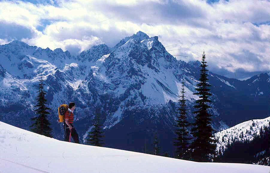
A person in winter gear with a backpack hiking across a snow-covered mountainside; tall, snow-dusted coniferous trees are visible, and jagged, snow-covered mountains rise in the distance under a partly cloudy sky.
A hiker traverses a snow-covered slope with rugged, snow-capped peaks in the background.

Mount Skokomish Wilderness history and protected-area timeline

Mount Skokomish Wilderness was established in 1984 when the U.S. Congress designated five wilderness areas within Olympic National Forest as part of a broader expansion of federally protected lands in the Pacific Northwest. The new designations, signed into law that year, included Buckhorn Wilderness, Colonel Bob Wilderness, Mount Skokomish Wilderness, The Brothers Wilderness, and Wonder Mountain Wilderness.

The 1984 designation placed Mount Skokomish Wilderness under stronger federal protection as part of the National Wilderness Preservation System. At the time of its establishment, the area was already managed as part of Olympic National Forest, but the wilderness designation added higher standards for preservation of natural conditions and limits on development and mechanized use.

In 1988, the much larger Olympic Wilderness, which lies adjacent to and west of Mount Skokomish Wilderness, was itself created. Today, Mount Skokomish Wilderness occupies a strategic position along the southeastern flank of this larger protected complex, functioning as a high-country buffer that extends the contiguous system of preserved Olympic landscapes administered by the U.S. Forest Service.

Mount Skokomish Wilderness landscape and geographic character

Mount Skokomish Wilderness is defined by a compact but dramatic ridgeline landscape typical of the eastern edge of the Olympic Mountains. Two long, rocky ridges run roughly northeast to southwest through the area, framing a central basin and producing a terrain of steep slopes, exposed rock, and narrow alpine benches. Elevations range from roughly 2,000 feet at the lower margins of the wilderness up to 6,434 feet at the summit of Mount Skokomish on the northwest boundary.

The northern ridge is one of the wilderness's most striking features. It rises through the summits of Mounts Skokomish, Lincoln, and Cruiser, with the jagged Sawtooth Ridge strung between Lincoln and Cruiser. Sawtooth Ridge has a particularly sharp, broken profile and is widely recognized as a notable rock-climbing location in the region. The southern ridge mirrors this ruggedness, encompassing Mounts Pershing, Washington, Rose, and Ellinor, as well as the lesser-known peaks of Jefferson Peak and Tran Spire.

Between the two ridges lies the relatively sheltered, forested basin that holds the headwaters of the Hamma Hamma River. Water collects in this basin from the Mildred Lakes and surrounding tributary streams before the river turns east and exits the wilderness. The combination of rocky alpine ridgelines above and forested, lake-dotted valleys below gives the wilderness a layered visual character that changes rapidly as elevation shifts.

Mount Skokomish Wilderness ecosystems, habitats, and plant life

The ecological character of Mount Skokomish Wilderness follows a classic eastern Olympic elevation gradient. At the lower elevations, the slopes are cloaked in old-growth forests of western hemlock, western red cedar, and Douglas fir, species that define the wet, temperate climate of the Olympic foothills. These stands include mature trees and layered understory typical of Pacific Northwest old-growth ecosystems.

As elevation increases, the forest composition shifts. Mid- and higher elevation slopes support various fir and pine species, with open, park-like stands giving way to thinner, more exposed subalpine forest. The highest elevations within the wilderness include patches of dwarf juniper and other hardy, low-growing vegetation adapted to harsh winds and thin soils along the ridgelines.

The basin between the two ridges, anchored by the Mildred Lakes and the headwaters of the Hamma Hamma River, functions as a wetter, more sheltered ecological setting within the wilderness. The combination of dense old-growth forest, snow-fed lakes, and steep alpine headwalls creates a landscape where transitions between ecological zones occur over short horizontal distances, making the wilderness an unusually compressed representation of eastern Olympic ecosystems.

Mount Skokomish Wilderness wildlife and species highlights

Mount Skokomish Wilderness supports a wildlife community typical of the eastern Olympic Mountains. Large mammals are a visible part of the area's fauna, with elk moving through the forested basins and lower slopes, black-tailed deer browsing in transitional habitats between forest and meadow, and black bears present throughout the wilderness. Mountain lions are also part of the local predator community, though they are rarely seen.

Higher elevations and rocky ridgelines provide habitat for species adapted to alpine and subalpine environments. Mountain goats inhabit the rougher terrain along the upper slopes and cliff bands, while marmots occupy talus fields and rocky outcrops near the summits. These alpine species are reliable indicators of the wilderness's higher-elevation character and contribute to its distinctiveness within Olympic National Forest.

Mount Skokomish Wilderness conservation status and protection priorities

Mount Skokomish Wilderness plays an important conservation role as a buffer and adjunct to the larger Olympic Wilderness. Its designated wilderness status, established in 1984, places it within the National Wilderness Preservation System and subjects it to higher standards of protection that emphasize the preservation of natural ecological processes and limits on development and mechanized use.

The wilderness protects a continuous block of habitat, including old-growth forests, subalpine stands, alpine ridges, and the headwaters of the Hamma Hamma River. Because the rivers and streams within the wilderness ultimately flow eastward toward Hood Canal, the area's conservation value extends beyond its boundaries, contributing to downstream water quality and habitat connectivity on the eastern Olympic Peninsula.

By preserving direct continuity with the much larger Olympic Wilderness, Mount Skokomish Wilderness strengthens the ecological integrity of the eastern Olympic Mountains as a whole, ensuring that habitat for species such as elk, black bear, and mountain goat remains connected across a broader landscape of protected terrain.

Top sights and standout views in Mount Skokomish Wilderness

Mount Skokomish Wilderness stands out for its compact, ridge-dominated terrain and the sheer density of named peaks within its borders, including Mount Skokomish, Mount Lincoln, Mount Cruiser, Mount Pershing, Mount Washington, Mount Rose, and Mount Ellinor. Sawtooth Ridge, a jagged spine between Mounts Lincoln and Cruiser, is one of the area's most recognizable landmarks and a notable rock-climbing destination.

Equally distinctive is the wilderness's role in protecting the headwaters of the Hamma Hamma River, which originate in the high basin of the Mildred Lakes before flowing east. This high country, paired with old-growth forests of hemlock, cedar, and Douglas fir in the lower valleys, makes the wilderness a compressed but rich cross-section of eastern Olympic ecosystems and a natural extension of the surrounding Olympic Wilderness.

Best time to visit Mount Skokomish Wilderness

Summer is the most accessible season in Mount Skokomish Wilderness, when snow has largely melted from the lower and middle elevations and the steep trails, including the Mildred Lakes Trail and Putvin Trail, become practical to hike. During this period, the lakes are accessible and the ridgelines offer clearer views, though the terrain remains demanding because of the steep pitches on most routes.

Late spring and early autumn can extend hiking opportunities, but higher elevations may still hold snow well into the season, particularly in the rockier upper basins. Winter transforms the wilderness into a snow-covered landscape suitable for snowshoeing and other snow-based travel, especially in the lower and middle elevations, where the terrain is more forgiving than the exposed alpine ridges.
Monthly climate preview

Long-term temperature and precipitation records measured at a representative coordinate

Mount Skokomish Wilderness Climate Normals and Monthly Weather Data

Representative point records for Mount Skokomish Wilderness outline measured long-term temperature ranges alongside changing monthly precipitation rates. Accessing the complete monthly climate profile allows detailed examination of twelve-month averages and historical normals.
Annual mean8 °C
1 °C16 °C
Jan
Feb
Mar
Apr
May11°
Jun13°
Jul16°
Aug16°
Sep13°
Oct
Nov
Dec
Warmest month
July

16.3 °C

Coolest month
December

1.4 °C

Wettest month
November

10.2 mm/day

Driest month
July

0.9 mm/day

Park location guide

Geography guide, regional context, and park location map for Mount Skokomish Wilderness

Mount Skokomish Wilderness park geography, regions, and map view in United States of America

Understand where Mount Skokomish Wilderness sits in United States of America through a broader geographic reading of the surrounding landscape, nearby location context, and its mapped position within the national park landscape.

How Mount Skokomish Wilderness fits into United States of America

The United States of America is a federal presidential republic and one of the world's largest countries by area and population. It consists of 50 states across a vast territory spanning multiple time zones, with its capital in Washington, D.C. and largest city in New York City. The nation has a diverse economy, influential political system, and significant cultural and military presence globally.

Wider geography shaping Mount Skokomish Wilderness in United States of America

The United States occupies a vast territory in North America, bordered by Canada to the north and Mexico to the south. The 48 contiguous states stretch from the Atlantic to the Pacific Ocean, while Alaska occupies the northwestern region and Hawaii is an archipelago in the Pacific. The country encompasses diverse terrain including the Rocky Mountains, Appalachian Mountains, Great Plains, and extensive river systems.

Map view of Mount Skokomish Wilderness

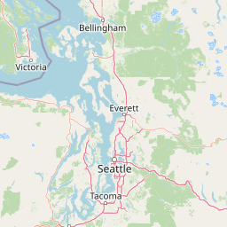
Use this park location map to pinpoint Mount Skokomish Wilderness in United States of America, understand its exact geographic position, and read its mapped placement within the surrounding landscape more clearly.

Pigeon | © OpenStreetMap contributors

Location context for Mount Skokomish Wilderness

Washington
Natural feature types

View the Geographic and Natural Feature Atlas for Mount Skokomish Wilderness

Navigate the complete dataset of named mountains, lakes, and streams within Mount Skokomish Wilderness. Use this collection to understand the spatial distribution of these features as they relate to the broader MoriAtlas mapping of the Pacific Northwest.
Recorded earthquake history

Review the Historical Earthquake Catalogue for Mount Skokomish Wilderness

Explore documented seismic events associated with the surrounding geography of Mount Skokomish Wilderness through a structured historical archive. This collection organized by MoriAtlas provides consistent access to recorded event details including magnitude, depth, and distance for researchers and geography enthusiasts.

Mount Skokomish Wilderness Earthquake History

Catalogued events

110 events

Strongest magnitude

Magnitude 5.8

Most recent event

Mar 6, 2025

This history includes earthquakes recorded inside the park or within 50 km of its borders

Examine protected area views, rugged mountain terrain, and old-growth forest habitats across the eastern Olympic range.

Mount Skokomish Wilderness Photos and Landscapes: Visual Exploration of Alpine Ridges

Visual documentation of Mount Skokomish Wilderness reveals the striking topography of parallel rocky ridges and sheltered river valleys. Protected area photography captures the rapid transition from dense lowland hemlock and cedar forests to high-elevation alpine environments.

A person in winter gear with a backpack hiking across a snow-covered mountainside; tall, snow-dusted coniferous trees are visible, and jagged, snow-covered mountains rise in the distance under a partly cloudy sky.

Park atlas

Compare adjacent mountain terrain and connected wilderness areas across the eastern Olympics.

Parks Near Mount Skokomish Wilderness and Surrounding Protected Landscapes

Browsing other protected areas near Mount Skokomish Wilderness reveals the broader ecological continuity of the Olympic Peninsula. Examining adjacent mountain reserves and forested river basins provides essential regional context for wild terrain comparison.
A watercolor painting showing a panoramic view of rolling mountain ranges and dense evergreen forests with a soft, misty aesthetic.
Protected landscapeWashington
Park boundaries overlap#1 closest

Northeast

Olympic National Forest: Atlas and Geographic Overview of Washington Protected Lands

Temperate rainforests, alpine ridges, and fjord shorelines

Olympic National Forest defines the outer reaches of the Olympic Mountains, featuring a massive expanse of old-growth conifers and high-precipitation temperate rainforests. This protected area connects diverse ecosystems ranging from the brackish waters of Hood Canal to rugged, snow-dusted subalpine ridges. Our detailed geographic mapping highlights the forest's role as a vital buffer and wilderness corridor within the broader Pacific Northwest landscape.

Area
2,541.89 km²
Established
1897
Relief
Mountain
Climate
Temperate
National parkWashington
Park boundaries overlap#2 closest

North

Olympic National Park National Park: Geographic Atlas and Protected Landscape Discovery

Explore its unique Washington landscape and mapped protected areas.

Olympic National Park serves as a key protected area within Washington, offering rich opportunities for geographic exploration. This detail page provides essential context on its designation as a national park, its mapped boundaries, and its contribution to the regional geography. Understand the park's specific landscape character and its role within the atlas of protected lands, facilitating a structured approach to discovering its natural terrain and geographic significance.

Area
3,733.8 km²
Established
1938
IUCN
II
Visitors
3.7M annual
A horizontal watercolor painting showing a panoramic view of a coastal landscape with green, tree-covered headlands, rocky sea stacks, and distant mountains under a pale sky.
Marine protected areaWashington
75 km away#3 closest

Northwest

Olympic Coast National Marine Sanctuary: Mapping the Washington Outer Coast Marine Protected Area

Pacific Ocean canyons, shelf ecosystems, and coastal wilderness

Defined by its proximity to the Olympic Peninsula, this marine protected area spans a rugged stretch of the Pacific Ocean. The sanctuary encompasses significant seafloor features including the Nitinat and Quinault canyons, alongside dynamic upwelling zones that support diverse marine life and complex tidal habitats.

Area
8,260 km²
Established
1994
IUCN
IV
Climate
Temperate
Nature reserveBritish Columbia
About 80 km away#4 closest

North

Race Rocks Ecological Reserve: Protected Marine Landscape and Island Geography

Nature reserve in the Strait of Juan de Fuca, British Columbia

Race Rocks Ecological Reserve is a geographically distinct protected area consisting of low-lying rocky islets and surrounding high-current marine waters. Located in the Strait of Juan de Fuca, the reserve is recognized for its intense tidal mixing, which supports productive food webs and diverse marine mammals. This site provides a vital window into the ecological dynamics of the Pacific coast through its role as a dedicated research and conservation zone.

Area
2.27 km²
Established
1980
IUCN
Ia
Relief
Lowland
A horizontal watercolor illustration featuring a waterfall on the left, a range of rolling mountains in the background, and clusters of trees in the midground, rendered in soft, blended colors.
Protected landscapeWashington
102 km away#5 closest

Southeast

Gifford Pinchot National Forest: Geographic Overview of Washington's Volcanic Cascade Protected Lands

Mapping volcanic peaks, deep river canyons, and old-growth wilderness corridors

Gifford Pinchot National Forest represents a major protected expanse in the Washington Cascades, characterized by a complex volcanic topography that includes active craters, cinder cones, and rugged lava fields. This atlas entry details the forest's primary geographic features, from the high-elevation alpine terrain of the Goat Rocks to the river-carved valleys of the Lewis and Cowlitz systems, providing essential context on this integral Pacific Northwest protected landscape.

Area
5,347.95 km²
Established
1908
Visitors
1.8M annual
Relief
Mountain
National parkBritish Columbia
106 km away#6 closest

North

Gulf Islands National Park Reserve: British Columbia National Park Protected Area

Mapped boundaries and regional geographic context.

Delve into the protected landscape of Gulf Islands National Park Reserve, a significant national park located in British Columbia. This entry provides detailed insights into its mapped boundaries, regional geographic setting, and its identity as a protected area. Understand the park's place within the natural terrain and atlas of Canada, offering a clear geographic overview for focused discovery and landscape context.

Area
36 km²
Established
2003
IUCN
VI
Visitors
28.4K annual
National parkWashington
112 km away#7 closest

Southeast

Mount Rainier National Park: A National Park in Washington with Distinct Mapped Boundaries

Explore its protected landscape and regional geography.

Mount Rainier National Park represents a core protected area within Washington State, offering rich opportunities for geographic discovery through its mapped boundaries and natural terrain. As a designated national park, it contributes significantly to the atlas of United States protected lands. This destination allows for detailed exploration of its landscape context, making it an essential point of reference for understanding regional geography and conservation areas.

Area
956.6 km²
Established
1899
IUCN
II
Visitors
1.6M annual
A watercolor painting showing a panoramic view of mountain peaks in the distance above green foothills and plains.
Protected landscapeWashington
113 km away#8 closest

East

Mount Baker, Snoqualmie National Forest: Mapped Geography and Protected Landscape Analysis

Exploratory atlas of Washington's primary Cascade Range wilderness

Delve into the structural geography of Mount Baker, Snoqualmie National Forest. This protected area corridor serves as a major ecological transition zone between the Puget Sound lowlands and the interior Cascades, characterized by extensive glaciers, wild river systems, and iconic stratovolcanoes that define the regional landscape of Washington state.

Area
6,978 km²
Established
1974
Relief
Mountain
Climate
Alpine

Common questions about visiting, size, designation, and location context for Mount Skokomish Wilderness

Mount Skokomish Wilderness FAQs for park facts, access, geography, and protected area context

Find quick answers about Mount Skokomish Wilderness, including protected-area facts, park geography, trail and visitor context, and how the park fits into its surrounding country and regional landscape.
MoriAtlas Explorer

Continue Your Protected Areas Search Across the Global Atlas

Deepen your exploration by continuing the structured search for national parks and protected areas worldwide. Utilize the comprehensive filtering capabilities to compare different conservation landscapes and refine your understanding of global park geography. Discover more about the distribution and characteristics of protected natural areas.

Global natural geography