
Lakes
Park geography
Structured map data detailing the regional elevation, terrain, and natural features
Geographic Profile and Landscape Mapping for the Mount Thielsen Wilderness in Oregon
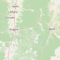
This geographic dataset provides an overview of the Mount Thielsen Wilderness in Oregon, covering a recorded land area of 223 square kilometers. The profile includes elevation measurements spanning from 1500 meters to 2799 meters, alongside a catalog of mapped natural features including glacial landscapes, forested terrain, peaks, lakes, and rivers.
A Cascade Range wilderness centered on Oregon's 'Lightning Rod of the Cascades.'
Mount Thielsen Wilderness
Mount Thielsen Wilderness is a congressionally designated wilderness area in the southern Cascade Range of Oregon, built around the volcanic peak of Mount Thielsen. The wilderness spans across portions of three national forests: Deschutes, Umpqua, and Fremont-Winema, and was established in 1984 as part of the National Wilderness Preservation System. The landscape rises from forested foothills to a sharply pointed mountain summit, with elevations spanning roughly 5,000 feet to over 9,000 feet. Glacial carving has sculpted much of the terrain, producing a mix of rolling ridges, steep dissected mountainsides, alpine lakes, and high-country forests. The wilderness is recognized as one of the more compact and dramatic Cascade Range protected areas in Oregon. To the south, the wilderness borders Crater Lake National Park, linking Mount Thielsen to a broader corridor of protected Cascade landscapes. Within the wilderness, the headwaters of the Wild and Scenic North Umpqua River begin at Maidu Lake, adding significant hydrological value to an already striking mountain environment.
- Location
- United States of America
- Park type
- Wildlife reserve
- Established
- 1984
- Area
- 223 km²
- Highest point
- 2,799 m
Location overview
Recorded country memberships and administrative state context
Mount Thielsen Wilderness Regional Geography and Location Atlas
Mount Thielsen Wilderness is located in the United States of America within the state of Oregon. Recorded administrative memberships establish the primary country and regional relationships for the protected area.
- Countries
- United States of America
- Regions
- Oregon
- Primary location
- Oregon
- Geographic setting
- Inland
Boundary and coordinates
Mount Thielsen Wilderness maps 223 km² of recorded land
Mount Thielsen Wilderness mapped boundary and 223 km² land area
Mount Thielsen Wilderness’s available outline spans 223 km² of protected land. It shows the wilderness footprint at atlas scale for discovery and comparison, not for determining surveyed limits.
- Boundary area
- 223.1 km²
- Boundary perimeter
- 94.5 km
- Northernmost point
- 43.3277° N
- Southernmost point
- 43.0953° N
- Easternmost point
- 121.9054° W
- Westernmost point
- 122.1036° W
- Geographic centre
- 43.2108° N, 122.0177° W
- North–south span
- 25.8 km
- East–west span
- 16.1 km
Elevation and terrain
Mountain relief metrics and recorded natural water and peak features
Mount Thielsen Wilderness Terrain and Elevation Range Geography
Recorded elevation metrics outline a mountain terrain profile spanning from 1500 meters to a highest point of 2799 meters. Associated feature cards document names, types, and spatial relationships for recorded peaks, lakes, and streams.
- Minimum elevation
- 1,500 m
- Maximum elevation
- 2,799 m
- Highest point
- 2,799 m
Selected named natural features
Streams
Camp Creek
Peaks
Red Cone
2,211 m
Volcanoes
Mount Thielsen
2,799.4 m
Streams
Tolo Creek
Peaks
Miller Mountain
2,287 m
Environmental setting
Temperate mountain relief, coniferous forest cover, and glacial terrain features
Mount Thielsen Wilderness Environmental Classifications and Physical Setting Profile
Recorded landscape features, habitat types, and climate classifications provide complementary ways to read the physical setting of Mount Thielsen Wilderness. Stored categories connect directly to relevant atlas destinations for regional environmental comparison.
- Relief
- Mountain
- Climate
- Temperate
- Water
- Minor water
- Forest cover
- Mostly forested
- Seasonality
- Seasonal
Landscape features
Mountains · Hills · Forest · Lakes · Rivers · Cliffs · Glacier · Volcano
Habitat types
Temperate coniferous forest · Montane forest · Glacial habitat
Park atlas
Compare adjacent southern Cascade volcanic peaks and protected mountain terrain.
Parks Near Mount Thielsen Wilderness, Discover Connected Protected Landscapes
Browse protected areas and national parks situated near Mount Thielsen Wilderness in the southern Cascade Range. Comparing adjacent mountain terrain helps reveal broader regional geology, connected forest ecosystems, and surrounding volcanic landscapes.
National parkOregon
0.7 km away#1 closest
South

Crater Lake National Park: Oregon National Park Atlas of Volcanic Landscapes
Explore mapped boundaries and unique caldera geography.
Crater Lake National Park represents a significant protected area within Oregon, defined by the dramatic volcanic caldera it contains. This national park is celebrated for its exceptionally deep, clear blue lake, formed by the collapse of Mount Mazama, offering a unique subject for geographic and landscape study. Users can explore its mapped boundaries and understand its position within the broader atlas of protected lands and mountainous terrain of the Cascade Range.
- Area
- 741.48 km²
- Established
- 1902
- IUCN
- II
- Visitors
- 527K annual

Protected landscapeOregon
6.4 km away#2 closest
Southwest
Rogue River, Siskiyou National Forest: Mapped Geography and Protected Area Overview
Tracing volcanic peaks and river-carved mountain terrain in Oregon
Spanning nearly 7,300 square kilometers, the Rogue River, Siskiyou National Forest acts as a crucial ecological anchor in the Pacific Northwest. This overview details its unique mountain geography, the extensive wilderness tracts within its boundaries, and the river systems that define its mountainous character.
- Area
- 6,973.46 km²
- Established
- 2004
- Visitors
- 915K annual
- Relief
- Mountain
Protected landscapeOregon
7.9 km away#3 closest
North
Willamette National Forest: Geography and Protected Landscapes of the Central Oregon Cascades
Mapped terrain, old-growth forests, and protected wilderness boundaries.
Explore the expansive territory of Willamette National Forest, a primary protected area extending over 100 miles along Oregon's Cascade Range. This region features volcanic peaks exceeding 10,000 feet, extensive old-growth Douglas-fir stands, and a dense network of Wild and Scenic rivers, providing a detailed look at the geographic character and ecological heritage of the Pacific Northwest.
- Area
- 6,790.75 km²
- Established
- 1933
- Visitors
- 1.7M annual
- Relief
- Mountain
Protected landscapeOregon
About 14 km away#4 closest
West
Umpqua National Forest: Mapping the Protected Landscapes and Volcanic Terrain of Southern Oregon
A regional geography of the southern Cascade Range
Umpqua National Forest protects a critical expanse of southern Oregon, rising from river-carved timbered valleys to the high volcanic peaks of the Cascade Range. This atlas record details the forest's significant volcanic geology, sprawling old-growth habitats, and the Wild and Scenic North Umpqua River system. Explore the intricate boundaries of its wilderness areas and its relationship to the surrounding regional terrain through detailed geographic mapping and landscape analysis.
- Area
- 3,978.58 km²
- Established
- 1907
- Visitors
- 799K annual
- Relief
- Mountain
Wildlife reserveOregon
20 km away#5 closest
Southwest
Rogue-Umpqua Divide Wilderness: Protected Ridge Landscape and Watershed Geography
High-country wilderness area in southwestern Oregon
Rogue-Umpqua Divide Wilderness preserves a dense, high-elevation ridge environment that separates the Rogue and Umpqua river drainages. Featuring a complex mix of volcanic and sedimentary rock outcrops within a continuous conifer canopy, the area offers a unique look at forest ecology in the Klamath Mountains. The geography provides extensive views across both watersheds and stands as a primary example of protected montane forest terrain within the Oregon landscape.
- Area
- 134 km²
- Established
- 1984
- IUCN
- Ib
- Water
- Minor water
Wildlife reserveOregon
79 km away#6 closest
South
Mountain Lakes Wilderness: Geographic Atlas of Oregon's Glacial Volcanic Reserve
Mapping the volcanic cirques and square boundaries of the southern Cascades.
Mountain Lakes Wilderness serves as a primary geographic anchor in the southern Cascades, where shield volcanoes meet glacially carved basins. This protected area contains over twenty lakes situated in high-altitude cirques near the summits of volcanic peaks like Aspen Butte. The area is defined by its distinctive square survey-township boundary, providing a clear footprint of wilderness conservation within the larger Fremont-Winema National Forest terrain.
- Area
- 93 km²
- Established
- 1964
- IUCN
- Ib
- Relief
- Mountain
Wildlife reserveOregon
98 km away#7 closest
North
Mount Washington Wilderness: Volcanic Geology and Forested Cascade Terrain
A mapped overview of Oregon protected volcanic landscapes.
Mount Washington Wilderness offers a stark and compelling geological study of Oregon's central Cascades. From the shield volcano's basaltic remnants to the fragmented cinder cones of Belknap Crater, the area provides a window into explosive and effusive volcanic activity. Our geographic data maps the transition of conifer forests and subalpine zones across its rocky, lake-dotted interior, highlighting the unique character of this quiet protected preserve.
- Area
- 219.66 km²
- Established
- 1964
- IUCN
- Ib
- Relief
- Mountain
Wildlife reserveOregon
108 km away#8 closest
Southeast
Gearhart Mountain Wilderness: Protected Mountain Geography and Forest Atlas
High elevation terrain in the Fremont Winema National Forest
Spanning the border between Lake and Klamath counties, Gearhart Mountain Wilderness stands as a testament to the diverse mountain geography of south-central Oregon. The area features a complex mosaic of white fir, ponderosa pine, and pure lodgepole stands, set within a glacially sculpted landscape of cirques and ridges. This protected refuge serves as a key headwater source and mountain sanctuary, offering expansive vistas that span from the southern Cascades to the far horizon of the Oregon desert landscape.
- Area
- 92.36 km²
- Established
- 1943
- IUCN
- Ib
- Relief
- Mountain
MoriAtlas Explorer
Examine the Mapped Geography and Terrain of Mount Thielsen Wilderness
Continue exploring the distinct glacial and volcanic features of Mount Thielsen Wilderness. MoriAtlas provides a structured view of this protected area, allowing you to trace its high-country boundaries, forest transitions, and hydrological connections within the broader Oregon Cascade Range.
Browse next
Global natural geography
Explore related park routes
Explore MoriAtlas Global ParksBrowse All MoriAtlas ParksGlobal Park Map DiscoveryMoriAtlas: Browse All CountriesBrowse All MoriAtlas ContinentsNational Park Environment AtlasGrand Canyon National Park AtlasYellowstone National Park AtlasYosemite National Park Atlas and GeographySerengeti National Park AtlasGalápagos National Park Protected LandscapeBanff National Park Geography and AtlasKruger National Park Atlas EntryUluṟu-Kata Tjuṯa National Park AtlasExplore Uluru-Kata Tjuta National Park GeographyPlitvice Lakes National Park AtlasFiordland National Park Protected LandscapeGreat Smoky Mountains National Park AtlasAfghanistan National Parks and Protected AreasAlbania National Parks and Protected AreasAlgeria National Parks and Protected AreasAmerican Samoa National Parks and Protected AreasAndorra National Parks and Protected AreasAngola National Parks and Protected AreasAntarctica National Parks and Protected AreasAntigua and Barbuda Park List