
Streams
Park geography
Analyzing the regional landscape, terrain features, and administrative boundaries in New South Wales
Comprehensive Geographic Profile and Mapped Boundaries of Murray Valley National Park
This geographic profile details the physical dimensions and environmental characteristics of Murray Valley National Park, spanning 416 square kilometers within New South Wales. It includes an analysis of local river systems, wetland habitats, and lowland terrain features, providing a structured overview of the park regional context.
Related tags
Red river gum forestWetland ecosystemsRiverina regionNew South Wales national parksEndangered species habitat
Vast red river gum forest and wetland ecosystem along the Murray River in southern New South Wales
Murray Valley National Park
Murray Valley National Park is a protected area in the Riverina region of New South Wales, Australia, established in July 2010. The park covers 41,601 hectares along the Murray River floodplain, representing one of the largest remaining stands of red river gum forest in Australia. This ecosystem is of exceptional ecological significance, forming a continuous forest corridor with the adjacent Barmah National Park in Victoria. The park encompasses a complex landscape of river channels, lagoons, wetlands, and forested flats that support remarkable biodiversity. Murray Valley National Park is also recognized as traditional Aboriginal country, holding deep cultural and historical significance for local Indigenous communities.
- Location
- Australia
- Park type
- National park
- Established
- 2010
- Area
- 416 km²
Location overview
Inland national park located within the Riverina region of Australia
Murray Valley National Park Geographic Location and Placement
Murray Valley National Park lies within the Riverina region of New South Wales in Australia. Geographic records confirm its status as a non-coastal, inland terrestrial reserve managed entirely within a single country.
- Countries
- Australia
- Regions
- New South Wales, Riverina
- Primary location
- New South Wales
- Geographic setting
- Inland
Boundary and coordinates
A 416.01 km² outline with extent measurements
Murray Valley National Park mapped boundary and land area
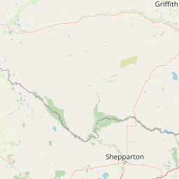
Murray Valley National Park is shown with a mapped 416.01 km² footprint, all recorded as land. The outline supports atlas-scale understanding of its spatial reach without asserting legal precision.
- Boundary area
- 395.8 km²
- Boundary perimeter
- 696 km
- Northernmost point
- 35.1765° S
- Southernmost point
- 36.0495° S
- Easternmost point
- 146.3692° E
- Westernmost point
- 143.8044° E
- Geographic centre
- 35.7918° S, 144.9964° E
- North–south span
- 96.9 km
- East–west span
- 232.4 km
Terrain and natural features
Explore lowland terrain classifications and recorded waterways
Murray Valley National Park Terrain And Named Natural Features Atlas
Murray Valley National Park features classified lowland terrain with recorded creeks, rivers, islands, and wetlands located within the protected boundary. Individual feature cards display specific types, names, and spatial relationships for each mapped natural landmark.
Selected named natural features
Rivers
Cornalla Creek
Streams
Erigin Creek
Rivers
Wakool River
Rivers
Wild Dog Creek
Streams
Stockyard Creek
Environmental setting
Temperate lowland forest, major river systems, and wetland habitats
Murray Valley National Park Environmental Classification and Physical Setting
Recorded classifications group dominant forest cover, lowland relief, and major water systems into complementary physical settings. Connected atlas records link these environmental categories directly to related protected areas.
- Relief
- Lowland
- Climate
- Temperate
- Water
- Major water bodies
- Forest cover
- Dense forest cover
- Seasonality
- Year-round
Landscape features
Forest · Rivers · Wetland · Valleys
Habitat types
Temperate broadleaf forest · Wetland · Riverine habitat · Lacustrine habitat
Park atlas
Compare surrounding national parks and protected landscapes across the Murray River floodplain geography.
Explore More Protected Areas Near Murray Valley National Park and the Riverina Region
Browse other protected areas and national parks adjacent to Murray Valley National Park, exploring the diverse Riverina region and the extensive Murray River floodplain ecosystem. This geographic overview aids in comparing the spread and conservation context of red river gum forests and wetland habitats across Australia's protected landscapes.
National parkAustralia
0 km away#1 closest
South

Barmah National Park National Park: World's Largest River Red Gum Forest Landscape
Explore Mapped Boundaries and Wetland Geography
Barmah National Park in Victoria, Australia, is renowned for protecting the largest river red gum floodplain forest on Earth, a globally significant Ramsar-listed wetland. This protected area's landscape is defined by majestic eucalypts bordering freshwater marshes along the Murray River. Dive into its distinct geography, mapped terrain, and the protected status of this remarkable ecosystem, offering unparalleled opportunities for understanding regional natural landscapes and conservation.
- Area
- 285.21 km²
- Established
- 2010
- IUCN
- II
- Relief
- Lowland
National parkAustralia
4.7 km away#2 closest
South
Lower Goulburn National Park: Australia's River Red Gum Woodland Protected Landscape
Explore mapped boundaries and riparian geography.
Lower Goulburn National Park in Victoria, Australia, safeguards a critical segment of the Goulburn River, celebrated for its magnificent river red gum woodlands. This protected area offers a linear exploration of a rare riparian ecosystem, providing essential habitat and scenic beauty. Understand its geographic layout, mapped extent, and the distinctive landscape formed by these iconic Australian trees, offering a vital natural contrast to the surrounding agricultural areas.
- Area
- 93.1 km²
- Established
- 2010
- IUCN
- II
- Relief
- Lowland
National parkAustralia
13 km away#3 closest
Southeast
Warby-Ovens National Park: Protected Landscape and Geographic Atlas Entry
Discover its Box-Ironbark forests and mapped regional terrain.
Warby-Ovens National Park is a protected national park situated in northeastern Victoria, Australia, covering 14,655 hectares of distinctive landscape. It is internationally recognized as an Important Bird Area, primarily for its significant Box-Ironbark forest ecosystem that supports numerous threatened woodland bird species. The park's geography features low granite hills and rolling terrain, with the Ovens River flowing through its northern section. This detail page provides structured information on its protected boundaries, natural landscape characteristics, and its place within regional geography.
- Area
- 146.55 km²
- Established
- 2010
- IUCN
- II
- Relief
- Upland
National parkAustralia
19 km away#4 closest
East
Chiltern-Mt Pilot National Park: Box-Ironbark Forest & Mapped Landscape
Explore its protected areas and regional geographic context.
Chiltern-Mt Pilot National Park preserves a significant portion of Victoria's box-ironbark forest, an ecosystem vital for threatened species and rich biodiversity. This park showcases varied terrain, from sedimentary hills to granite landscapes, offering a compelling subject for geographic study. Understand its mapped extent and its role within the broader regional geography, providing deep insights for atlas-based exploration.
- Area
- 215.6 km²
- Established
- 2002
- IUCN
- II
- Relief
- Mixed relief
National parkAustralia
24 km away#5 closest
West
Gunbower National Park: A National Park Protecting River Red Gum Forests and Ramsar Wetlands
Explore its mapped riverine landscape and regional protected area context.
Gunbower National Park offers a unique glimpse into Victoria's vital floodplain ecosystems, prominently featuring extensive River Red Gum forests and Ramsar-designated wetlands. This protected national park, situated along the Murray River, serves as a crucial sanctuary for migratory bird species within the Murray-Darling Basin. Its landscape is defined by waterways like Gunbower Creek and a mosaic of aquatic habitats, representing an important conservation area for its ecological communities and geographic significance.
- Area
- 93.3 km²
- Established
- 2010
- IUCN
- II
- Relief
- Lowland
National parkAustralia
34 km away#6 closest
Southwest
Terrick Terrick National Park: National Park Geography and Protected Land Exploration
Semi-arid woodland and grassland ecosystems in northern Victoria.
Terrick Terrick National Park represents a crucial protected area showcasing the characteristic Box-Ironbark forest and native grassland ecosystems of northern Victoria. This park is defined by its gently undulating terrain and semi-arid woodland character, offering a distinct natural landscape for geographic study and atlas exploration. Its mapped extent clearly delineates an environment vital for conservation, providing a valuable point of reference for understanding regional protected land distribution and ecological significance within Australia.
- Area
- 38.8 km²
- Established
- 1988
- IUCN
- II
- Relief
- Lowland
National parkNew South Wales
48 km away#7 closest
Northwest
Yanga National Park National Park: Mapped Boundaries and Regional Geographic Context in New South Wales
Protected landscape atlas entry for New South Wales.
Examine Yanga National Park, a dedicated national park situated in New South Wales, Australia. This entry provides essential details for atlas-based discovery, focusing on its mapped boundaries, protected area status, and integration into the regional geography. Understanding Yanga National Park contributes to a broader comprehension of protected lands and their distribution, offering a clear geographic perspective on conservation efforts within New South Wales for users seeking structured landscape data.
- Area
- 667.34 km²
- Established
- 2007
- IUCN
- II
- Relief
- Lowland
Nature reserveNew South Wales
About 56 km away#8 closest
East
Wiesners Swamp Nature Reserve: Mapping the Floodplain Landscapes of New South Wales
A preserved ephemeral wetland and woodland habitat
Wiesners Swamp Nature Reserve represents a critical protected wetland basin in the South Western Slopes of New South Wales. The reserve provides a mapped view of seasonal floodplain dynamics, including river red gum woodland and woodland patches on higher ground that support local waterbirds and native mammals.
- Area
- 1.03 km²
- Established
- 1996
- IUCN
- Ia
- Relief
- Lowland
MoriAtlas Explorer
Continue Your Atlas Exploration of Murray Valley National Park's Geography
Delve deeper into the structured geographic data for Murray Valley National Park. Understanding its specific mapped boundaries and position within the New South Wales landscape provides critical context for your atlas-based discovery. Expand your knowledge of protected areas and their natural terrain by exploring this key national park entity further.
Browse next
Global natural geography
Explore related park routes
Explore MoriAtlas Global ParksBrowse All MoriAtlas ParksGlobal Park Map DiscoveryMoriAtlas: Browse All CountriesBrowse All MoriAtlas ContinentsNational Park Environment AtlasGrand Canyon National Park AtlasYellowstone National Park AtlasYosemite National Park Atlas and GeographySerengeti National Park AtlasGalápagos National Park Protected LandscapeBanff National Park Geography and AtlasKruger National Park Atlas EntryUluṟu-Kata Tjuṯa National Park AtlasExplore Uluru-Kata Tjuta National Park GeographyPlitvice Lakes National Park AtlasFiordland National Park Protected LandscapeGreat Smoky Mountains National Park AtlasAfghanistan National Parks and Protected AreasAlbania National Parks and Protected AreasAlgeria National Parks and Protected AreasAmerican Samoa National Parks and Protected AreasAndorra National Parks and Protected AreasAngola National Parks and Protected AreasAntarctica National Parks and Protected AreasAntigua and Barbuda Park List