Why Namtok Mae Surin National Park stands out
Namtok Mae Surin National Park is best known for its namesake Mae Surin waterfall, an impressive single-tier cascade dropping 180 meters from the surrounding mountain slopes. This dramatic waterfall is among the taller waterfalls in northern Thailand and serves as the park's defining natural landmark. The park is also notable for its geological diversity, encompassing both the mountainous terrain of the Thanon Thongchai Range and unique cave systems such as Nam Hu Haichai Cave, where a water jet erupts from interior walls at regular intervals. The combination of highland forest ecosystems, significant waterfalls, and cave formations makes this park a distinctive protected area within Thailand's network of national parks.
Namtok Mae Surin National Park history and protected-area timeline
Namtok Mae Surin National Park was established in 1981, becoming Thailand's 37th national park and one of the earliest protected areas designated in the country's northern highland region. The establishment came during a period when Thailand was systematically expanding its national park system to include representative examples of the nation's diverse ecological zones. The park's creation recognized both the outstanding natural beauty of its waterfall and mountain landscapes as well as the ecological importance of the forests and wildlife habitats within the Thanon Thongchai Range. Since designation, the park has been managed by Thailand's Department of National Parks, Wildlife and Plant Conservation, which oversees visitor access, resource protection, and conservation programs within the protected area. The park's establishment also acknowledged the need to regulate land use in a region where deforestation pressures and agricultural expansion threatened remaining forest cover.
Namtok Mae Surin National Park landscape and geographic character
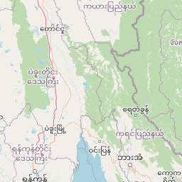
The physical landscape of Namtok Mae Surin National Park is defined by the mountainous terrain of the Thanon Thongchai Range, a north-south trending mountain chain that forms part of the natural boundary between Thailand and Myanmar. The park's topography features steep-sided valleys, rocky ridges, and numerous streams that cascade down the mountain slopes, eventually joining the Pai River system that flows through the region. Elevation ranges dramatically across the park from approximately 300 meters in the lower valleys to 1,685 meters at Doi Pui peak, creating distinct ecological zones that transition from warm broadleaf forests at lower elevations through mixed deciduous and dipterocarp forest to cool pine forests on the highest slopes. The most prominent geological feature is Mae Surin waterfall, where a single stream plunges 180 meters over a vertical cliff face, creating one of the most visually striking waterfalls in northern Thailand. Additional waterfall features include Pa Bong, a two-tier cascade dropping roughly 30 meters, while the park also contains several limestone cave formations including Nam Haichai Cave with its unusual periodic water jet phenomenon.
Namtok Mae Surin National Park ecosystems, habitats, and plant life
The ecological character of Namtok Mae Surin National Park reflects the transitional nature of its location within the Thanon Thongchai Range, where multiple forest types meet across the elevational gradient. At lower elevations, the park supports deciduous and dipterocarp forests characterized by species such as Dipterocarpus alatus and Terminalia bellirica, trees adapted to seasonal monsoon climates with distinct wet and dry periods. As elevation increases, the forest transitions to pine-dominated communities including Pinus latteri and Pinus kesiya, which form extensive stands on the cooler upper slopes and ridgelines. The park also supports a notable population of lady slipper orchids, a rare and indigenous species that represents the botanical diversity found within these protected montane forests. The combination of forest types, elevation range, and proximity to water features creates a complex of habitats that supports varied plant communities throughout the seasons.
Namtok Mae Surin National Park wildlife and species highlights
The fauna of Namtok Mae Surin National Park includes several species of conservation significance within the broader Southeast Asian region. Mammal species recorded within the park include the Malayan sun bear and Asiatic black bear, both species that rely on forest habitats and face pressures from habitat loss across their ranges. The serow, a goat-antelope adapted to steep mountainous terrain, inhabits the rocky sections of the park, while smaller mammals include barking deer and wild boar that occupy various habitat types throughout the protected area. Primates are represented by the lar gibbon, which inhabits the forest canopy in the park's more mature forest sections. Reptile species include python and cobra, representing the diverse snake fauna found in Thailand's forests. Birdlife features drongo and hornbill species, with hornbills particularly notable as indicators of healthy forest ecosystems given their requirements for large trees for nesting. The combination of forest-dwelling mammals, primates, reptiles, and birds reflects the ecological diversity that the protected area helps to sustain.
Namtok Mae Surin National Park conservation status and protection priorities
Namtok Mae Surin National Park serves as an important conservation zone within Thailand's protected area network, preserving representative examples of highland forest ecosystems in the country's far north. The protected status helps maintain watershed functions critical to downstream communities and agricultural areas, while also safeguarding habitat for species that depend on the forest environments found within the Thanon Thongchai Range. The park's designation as IUCN category II reflects its primary purpose of protecting natural ecosystems while allowing for limited visitor access and environmental education. Conservation value is enhanced by the park's location connecting to other protected areas in the broader region, creating potential for wildlife movement and ecological processes across a larger landscape. The presence of species such as sun bear and Asiatic black bear, both listed as vulnerable, underscores the importance of maintaining connected forest habitats in this mountainous region.
Top sights and standout views in Namtok Mae Surin National Park
The defining highlight of Namtok Mae Surin National Park is the Mae Surin waterfall itself, a spectacular 180-meter single-tier cascade that ranks among Thailand's most impressive waterfalls. The waterfall's dramatic drop from the surrounding mountain slopes creates a striking visual feature that draws visitors seeking to experience the natural beauty of northern Thailand's highland landscapes. Beyond the main waterfall, the park offers additional waterfall attractions including Pa Bong with its two-tier structure, while the geological curiosity of Nam Hu Haichai Cave provides an unusual cave experience with its periodic water jet. The mountain trails ascending toward Doi Pui peak offer hikers access to panoramic views across the Thanon Thongchai Range, while the diverse forest environments from dipterocarp to pine provide visual variety as visitors move through different elevational zones. The relatively low visitor numbers compared to more famous Thai national parks contribute to a sense of remoteness and wilderness within this protected mountain landscape.
Best time to visit Namtok Mae Surin National Park
The optimal time to visit Namtok Mae Surin National Park corresponds to Thailand's cool dry season from November through February, when temperatures are moderate and rainfall is minimal, making trail conditions favorable for hiking and waterfall viewing most accessible. The surrounding landscapes remain green from the preceding monsoon season while visibility improves, allowing clearer views from higher elevations within the park. The hot season from March through May brings higher temperatures that can make strenuous activities challenging, particularly on exposed ridgelines and during midday hours. The monsoon season from June through October brings heavy rainfall that can affect trail accessibility and increase stream flows, though the waterfalls themselves may be more impressive during and immediately after periods of heavy rain. Visitors planning trips should consider that trail conditions and facility access may vary seasonally, and the remote nature of the park means that some services and infrastructure are limited compared to more developed destinations.