
Streams
Park geography
Detailed terrain, elevation, and hydrologic context for protected lands in North Carolina
Comprehensive Geographic Profile and Mapped Boundaries of Nantahala National Forest
This geographic profile provides an overview of the landscape characteristics and boundary data for Nantahala National Forest. The dataset includes elevation ranges from 366 to 1768 meters, major riverine systems, and extensive temperate forest habitats across a recorded 2150 square kilometer area within North Carolina.

The largest national forest in North Carolina, set in the misty ridges and deep gorges of the southern Appalachians.
Nantahala National Forest
Nantahala National Forest is the largest of the four national forests in North Carolina, covering a vast tract of mountains, valleys, and river gorges in the western part of the state. It lies within the Appalachian temperate rainforest and ranks as the second wettest region in the continental United States after the Pacific Northwest, giving the landscape its characteristic lush forests, abundant waterfalls, and clear trout streams. The forest takes its name from the Cherokee phrase meaning "Land of the Noonday Sun," a reference to the deep gorges where sunlight only reaches the valley floor near midday. This landscape forms part of the broader southern Appalachian Mountains and has been home to the Cherokee and their indigenous ancestors for thousands of years. Today the forest is a major conservation landmark, a destination for outdoor recreation, and a defining piece of western North Carolina's natural and cultural identity. Beyond its environmental significance, Nantahala is closely tied to American conservation history, with its formal establishment shaped by early twentieth century efforts to protect eastern forests that had been heavily logged. The forest now encompasses old-growth groves, designated wilderness areas, major long-distance hiking trails, and iconic rivers such as the Nantahala and the Hiwassee.
- Location
- United States of America
- Park type
- Protected landscape
- Established
- 1920
- Area
- 2,150 km²
- Highest point
- 1,768 m
Location overview
United States of America and North Carolina administrative memberships
Nantahala National Forest Geography and Regional Location Profile
Nantahala National Forest is situated within the United States of America, specifically anchored in North Carolina. Administrative records confirm single nation jurisdiction without transboundary, coastal, or marine status.
- Countries
- United States of America
- Regions
- North Carolina
- Primary location
- North Carolina
- Geographic setting
- Inland
Boundary and coordinates
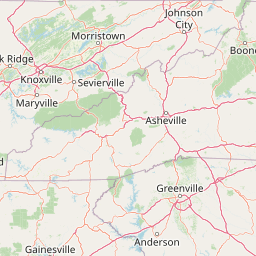
Nantahala National Forest maps 2,150 km² of recorded land
Nantahala National Forest mapped boundary and 2,150 km² land area
Nantahala National Forest’s atlas geometry spans 2,150 km² of recorded land. It gives readers a useful sense of the forest’s extensive footprint, while formal records determine exact boundary lines.
- Boundary area
- 2,151.4 km²
- Boundary perimeter
- 3,819.1 km
- Northernmost point
- 35.4647° N
- Southernmost point
- 34.9867° N
- Easternmost point
- 82.9197° W
- Westernmost point
- 84.2953° W
- Geographic centre
- 35.2086° N, 83.6157° W
- North–south span
- 53 km
- East–west span
- 125.2 km
Elevation and terrain
Vertical range profile and recorded natural features across the protected landscape
Nantahala National Forest Elevation and Mountain Terrain Geography
Recorded elevation metrics span from 366 meters to a high point of 1768 meters within the mountain terrain. Individual feature cards list names, types, and spatial relationships for streams, peaks, and waterfalls.
- Minimum elevation
- 366 m
- Maximum elevation
- 1,768 m
- Highest point
- 1,768 m
Selected named natural features
Waterfalls
Merge Lane Falls
Streams
Cold Creek
Peaks
Shope Knob
1,072 m
Rivers
Cullasaja River
Peaks
Beal Knob
1,368 m
Environmental setting
Temperate climate zones, dominant forest cover, and mountain relief profiles
Nantahala National Forest Environmental Classifications and Physical Setting
Recorded habitat types and landscape features serve as interpretive categories for reading the physical setting of Nantahala National Forest. Individual classification records link directly to relevant protected area categories across the broader geographic atlas.
- Relief
- Mountain
- Climate
- Temperate
- Water
- Major water bodies
- Forest cover
- Dense forest cover
- Seasonality
- Year-round
Landscape features
Mountains · Valleys · Forest · Lakes · Rivers · Waterfalls · Coast
Habitat types
Temperate broadleaf forest · Temperate coniferous forest · Montane forest · Riverine habitat · Lacustrine habitat
Park atlas
Compare adjacent southern Appalachian wilderness areas and regional mountain terrain.
Other Parks Near Nantahala National Forest and Surrounding Protected Areas
Browse nearby national forests and protected landscapes sharing the rugged topography of Nantahala National Forest. This regional comparison connects visitors to surrounding mountain reserves and river gorge ecosystems across the southern Appalachians.

Wildlife reserveUnited States of America
Park boundaries overlap#1 closest
Southeast

Ellicott Rock Wilderness: Geographic and Historic Protected Landscape Overview
A rare tri-state wilderness in the Southern Appalachian Mountains
Discover the mapped terrain of Ellicott Rock Wilderness, a protected area defined by its steep river gorges, dense cove forests, and unique position at the tripoint of three U.S. states. This wilderness area preserves the Chattooga River corridor and historic survey landmarks within the southern Blue Ridge Mountains, offering deep insight into the regional geography of the American southeast.
- Area
- 33.48 km²
- Established
- 1975
- IUCN
- Ib
- Relief
- Mountain
Wildlife reserveNorth Carolina
Park boundaries overlap#2 closest
West
Joyce Kilmer-Slickrock Wilderness: Mapped Topography and Protected Forest Boundaries
Old-growth Appalachian wilderness in North Carolina
Analyze the dramatic valley-and-ridge geography of the Joyce Kilmer-Slickrock Wilderness. This protected area, encompassing the rare Joyce Kilmer Memorial Forest, serves as a vital reference for eastern forest conservation, featuring ancient hardwood groves and sweeping mountain vistas across the Unicoi range.
- Area
- 70 km²
- Established
- 1975
- IUCN
- Ib
- Relief
- Mountain

Protected landscapeNorth Carolina
Park boundaries overlap#3 closest
East
Pisgah National Forest: Protected Appalachian Mountain Geography and Regional Mapping
An extensive mountain forest in western North Carolina
Pisgah National Forest represents a major protected landscape in the southern Appalachian Mountains of North Carolina. Its diverse terrain includes high peaks above 6,000 feet, dense hardwood forests, and deep river gorges. Recognized as a historic center for professional forestry, the area protects extensive watersheds and wilderness zones, offering a detailed case study in Appalachian geography, conservation science, and rugged mountain topography.
- Area
- 2,075.06 km²
- Established
- 1916
- Relief
- Mountain
- Climate
- Temperate

Protected landscapeSouth Carolina
Park boundaries overlap#4 closest
East
Sumter National Forest: Mapping Protected Landscapes and Terrain in South Carolina
Bridging Piedmont forests and Appalachian mountain foothills
Sumter National Forest offers a study in geographic contrast, as its three districts span the transition from South Carolina Piedmont ridges to the rugged spurs of the Blue Ridge Mountains. This protected area features the Chattooga Wild and Scenic River corridor, expansive hardwood-conifer mosaics, and complex mountain watersheds. The forest provides a window into regional land restoration, where reclaimed farmland and mountain ridges now form a continuous network of protected natural terrain.
- Area
- 1,500.98 km²
- Established
- 1936
- Relief
- Mixed relief
- Climate
- Temperate
National parkTennessee
0.1 km away#5 closest
North
Great Smoky Mountains National Park: Exploring Its Protected Landscape and Regional Geography
Tennessee's premier national park, mapped for landscape discovery.
Delve into the protected area identity of Great Smoky Mountains National Park, a significant natural landmark within Tennessee. This page provides detailed context on its mountainous terrain, mapped ecological zones, and its foundational role in the broader geography of eastern North America. Understanding the park's specific protected landscape features and its geographic setting is essential for appreciating its unique conservation value.
- Area
- 2,114.15 km²
- Established
- 1934
- IUCN
- II
- Visitors
- 12.2M annual

Wildlife reserveNorth Carolina
0.2 km away#6 closest
East
Middle Prong Wilderness: High-Elevation Appalachian Forest and Watershed Geography
Rugged ridges and headwaters in the Pisgah National Forest
Middle Prong Wilderness encompasses nearly 7,900 acres of protected southern Appalachian terrain. This rugged landscape, ranging from deep valley floors to wind-swept high-elevation ridges, serves as a vital protected corridor adjacent to Shining Rock Wilderness, showcasing a complex mosaic of hardwood and spruce-fir forest ecosystems within the Blue Ridge Mountains.
- Area
- 32 km²
- Established
- 1984
- IUCN
- Ib
- Relief
- Mountain
Wildlife reserveTennessee
18 km away#7 closest
West
Gee Creek Wilderness: Geographic Atlas of an Appalachian Forested Wildlife Reserve
Protected mountain terrain in the Tennessee foothills
Gee Creek Wilderness is a federally protected area in southeastern Tennessee characterized by its small, roadless footprint and rich Appalachian forest composition. The reserve showcases the dramatic intersection of forested ridgelines and stream-carved valleys, providing a concentrated look at the ecological character of the Cherokee National Forest's lower Appalachian zone.
- Area
- 10.09 km²
- Established
- 1975
- IUCN
- Ib
- Relief
- Upland

Wildlife reserveGeorgia
29 km away#8 closest
Southwest
Raven Cliffs Wilderness: Exploring the Appalachian Ridges and Protected Forest Landscapes
High-elevation wilderness area in northern Georgia.
Spanning steep ridges and narrow valleys, Raven Cliffs Wilderness represents a significant protected area within the Chattahoochee National Forest. The landscape transitions from high, exposed ridgelines to dense hardwood forest, offering a compact yet varied study in Appalachian mountain geography.
- Area
- 36.89 km²
- Established
- 1986
- IUCN
- Ib
- Relief
- Mountain
MoriAtlas Explorer
Continue Exploring the Geographic Boundaries of Nantahala National Forest
Gain a deeper understanding of the Nantahala National Forest through this structured geographic profile. MoriAtlas provides detailed insight into the forest's rugged Appalachian terrain, protected water corridors, and regional landscape context. Use these resources to visualize the mountain ridges and river systems that define this major conservation area in North Carolina.
Browse next
Global natural geography
Explore related park routes
Explore MoriAtlas Global ParksBrowse All MoriAtlas ParksGlobal Park Map DiscoveryMoriAtlas: Browse All CountriesBrowse All MoriAtlas ContinentsNational Park Environment AtlasGrand Canyon National Park AtlasYellowstone National Park AtlasYosemite National Park Atlas and GeographySerengeti National Park AtlasGalápagos National Park Protected LandscapeBanff National Park Geography and AtlasKruger National Park Atlas EntryUluṟu-Kata Tjuṯa National Park AtlasExplore Uluru-Kata Tjuta National Park GeographyPlitvice Lakes National Park AtlasFiordland National Park Protected LandscapeGreat Smoky Mountains National Park AtlasAfghanistan National Parks and Protected AreasAlbania National Parks and Protected AreasAlgeria National Parks and Protected AreasAmerican Samoa National Parks and Protected AreasAndorra National Parks and Protected AreasAngola National Parks and Protected AreasAntarctica National Parks and Protected AreasAntigua and Barbuda Park List