
Mori Atlas logo
National parkNarwiański Park Narodowy

Examining the anastomosing river channels, marshland mosaics, and wetland ecology within the Upper Narew valley.

Narwiański Park Narodowy: A Deep Geographic Analysis of Poland's Remarkable River Floodplain Landscape

Narwiański Park Narodowy protects a distinct lowland wetland environment in northeastern Poland. Spanning the broad floodplain of the Upper Narew River, this landscape is defined by a complex anastomosing network of channels, oxbows, and seasonally flooded meadows. The terrain features scattered mineral mounds known as grądziki, which provide dry ground amidst the expansive marshy plains and reed beds of the Podlaskie Voivodeship.

wetlandsfloodplainanastomosing rivermarshlandbirdwatchingImportant Bird Area
A flat vector-style illustration of a marshy landscape with a wooden boardwalk leading to a two-story observation tower; a metal truss bridge spans the river in the background, with cattails in the foreground.

Narwiański Park Narodowy

National park

Park overview

Structured park overview, official facts, and landscape profile for Narwiański Park Narodowy

Narwiański Park Narodowy park facts, protected area profile, and essential visitor context

Review the core facts for Narwiański Park Narodowy, including designation, size, terrain, visitor scale, habitats, and operating context in one park-focused overview.

About Narwiański Park Narodowy

Narwiański Park Narodowy is a lowland wetland national park in northeastern Poland, dedicated to protecting the unusual braided floodplain of the Upper Narew River. Created in 1996, it represents one of the last relatively intact examples of an anastomosing river system in Central Europe, where the Narew splits into multiple intertwined channels across a broad valley rather than cutting a single deepening course.

The landscape surrounding the river combines active channels with abandoned, gradually silting arms overgrown by reeds, large sedges, willow shrubs, and alder carrs. Mineral mounds, locally called grądziki, rise above the wet terrain as small dry islands, carrying grassland and oak-hornbeam communities that contrast sharply with the surrounding marshes. Together these elements form a finely patterned mosaic that has been maintained for centuries by traditional small-scale mowing and grazing, and that continues to define the visual identity of the park today.

The park's ecological significance lies in this combination of intact hydrology and traditional land use. It supports internationally important breeding populations of marshland and water birds, a rich community of amphibians and fish, and large mammals such as moose and European deer that move through the wet forest corridors. Its recognition by BirdLife International as an Important Bird Area underlines its role as a refuge for species that have declined across much of their wider European range.

In addition to its natural values, Narwiański Park Narodowy carries notable cultural and historical interest. The historic manor house at Kurowo, which once served as the park administration, now houses an exhibition on the natural and cultural heritage of the Narew valley. Nearby, remnants of an embankment and bridge abutments recall the pre-war road between Białystok and Warsaw, lending an additional layer of human history to the landscape. A long wooden footbridge connecting the villages of Waniewo and Śliwno crosses part of the floodplain and is one of the park's signature visitor landmarks, while traditional flat-bottomed boats called pychówki offer a quiet way to experience the slow-moving waters.

Quick facts and research context for Narwiański Park Narodowy

Narwiański Park Narodowy covers approximately 6,810 hectares in the Upper Narew valley, within the Podlaskie Voivodeship of northeastern Poland. It was established by law on 1 July 1996 and is one of the country's younger national parks. The protected section of the Narew River runs roughly 50 km between Suraż and Rzędziany, with a valley width of 2 to 4 km.

The area sits in the Dolina Górnej Narwi mesoregion of the Nizina Północnopodlaska and is built on an anastomosing river system rather than a single main channel. About 58 plant communities are recognized, dominated by large sedge, reed, and willow vegetation, and around 500 vascular plant species have been recorded. The park is also recognized as an Important Bird Area, with more than 200 bird species documented and over 150 breeding species.

Protection and recognition

Examine the official terrestrial protection scope and documented designation framework.

Narwiański Park Narodowy Protection Status and Conservation Recognition

Terrestrial protection status and documented designation records outline the conservation framework established for Narwiański Park Narodowy. Structured recognition facts detail the administrative scope associated with this protected natural area.

Protection details

Protection scope
Terrestrial
Transboundary protection
No
Buffer area
154.08 km²
Park context

Deeper park guide and search-rich context for Narwiański Park Narodowy

Narwiański Park Narodowy history, landscape, wildlife, and travel context

Explore Narwiański Park Narodowy through its history, landscape character, ecosystems, wildlife, conservation priorities, cultural context, and seasonal travel timing in a structured park guide built for atlas discovery and search intent.

Why Narwiański Park Narodowy stands out

Narwiański Park Narodowy is best known for protecting one of the most exceptional anastomosing river systems in Poland. The Narew here spreads into a dense, shifting lattice of channels, oxbows, and backwaters, creating a wetland mosaic that is almost without parallel in the country. This unusual hydrology supports an exceptionally rich bird community and is the reason the valley was designated an Important Bird Area. The park is also recognized as one of Europe's key strongholds for the aquatic warbler, a globally threatened marshland songbird that depends on sedge-dominated floodplain meadows. Traditional hay-making has long shaped the habitat mosaic that these birds and many other wetland species depend on, blending ecological value with cultural landscape heritage.
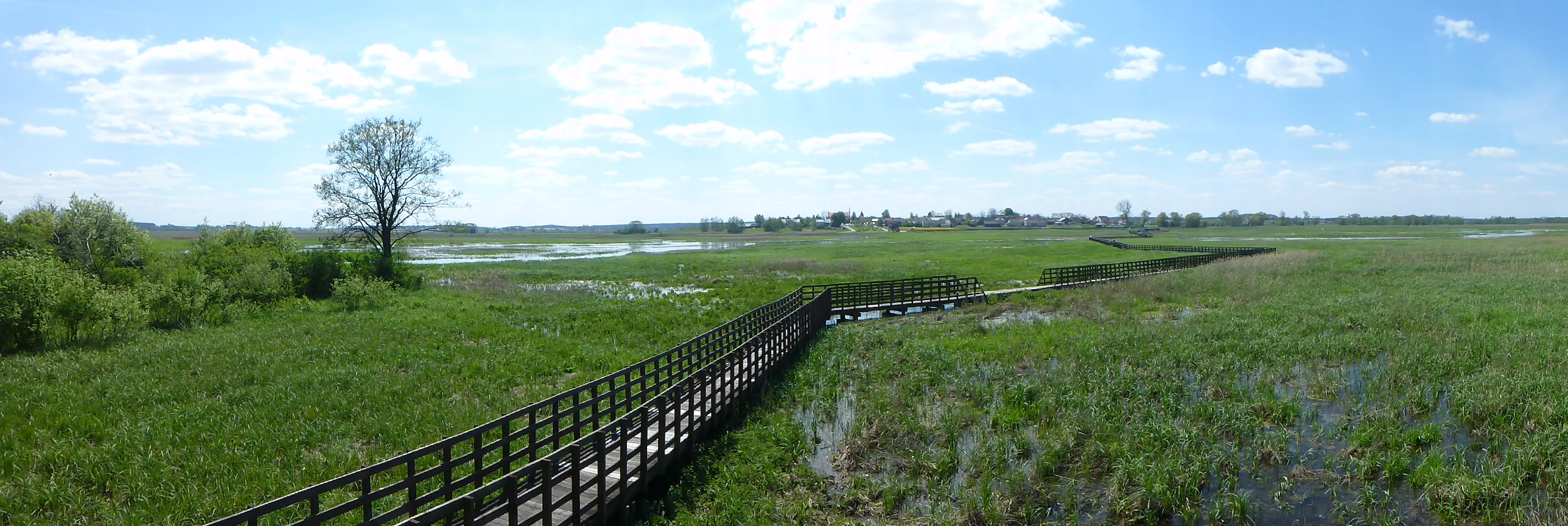
A wide panoramic view of a long wooden boardwalk crossing a vast green wetland area under a bright sky with scattered clouds in Narew National Park.
The Sliwno-Waniewo wooden footbridge stretches across the lush wetlands of Narew National Park.

Narwiański Park Narodowy history and protected-area timeline

Narwiański Park Narodowy was officially established on 1 July 1996 by an act of Polish law published in the Dziennik Ustaw, becoming one of the country's newer national parks. Its creation responded to growing recognition of the ecological value of the Upper Narew floodplain, an increasingly rare example of an anastomosing river system in Central Europe.

The original legal area was stated as 7,350 hectares, reflecting imprecise early measurements that have since been revised to approximately 6,810 hectares. Surrounding the park, a buffer zone of about 15,408 hectares was declared to protect the broader landscape and to manage the edge between the protected core and neighboring farmland and settlements.

For its first two decades, the park's administration was based in the nineteenth-century manor at Kurowo, a building of cultural significance in its own right. The administration later moved to Młynarzówka. Today the Kurowo manor is used as an exhibition space interpreting the natural and cultural heritage of the Narew valley, linking the park's conservation mission with the region's local history.

Narwiański Park Narodowy landscape and geographic character

The landscape of Narwiański Park Narodowy is fundamentally shaped by water. The Narew River flows here through a flat, broad valley between Suraż and Rzędziany, but instead of a single channel, the water spreads into a branching, reconnecting web of streams, oxbows, and temporary flood channels. This anastomosing pattern produces a constantly shifting mosaic of flowing water, still backwaters, wet meadows, and reedy marshes.

The valley is roughly 2 to 4 km wide, and the protected river section is about 50 km long. Along its edges, mineral mounds locally called grądziki rise modestly above the wet plain, providing dry ground for oak-hornbeam woodland remnants, small meadows, and tall herb communities. These drier spots stand out sharply against the surrounding marsh vegetation and give the landscape its characteristic patchiness.

The terrain itself is low-lying, part of the Nizina Północnopodlaska plain in the Dolina Górnej Narwi mesoregion. Rather than dramatic elevation, the scenery is defined by openness, gentle gradients, expansive skies, and the constant visual interplay between water, green marsh, and yellow sedge. The result is a quiet, contemplative wetland landscape very different from the mountains, dunes, or primeval forests associated with many of Poland's other national parks.
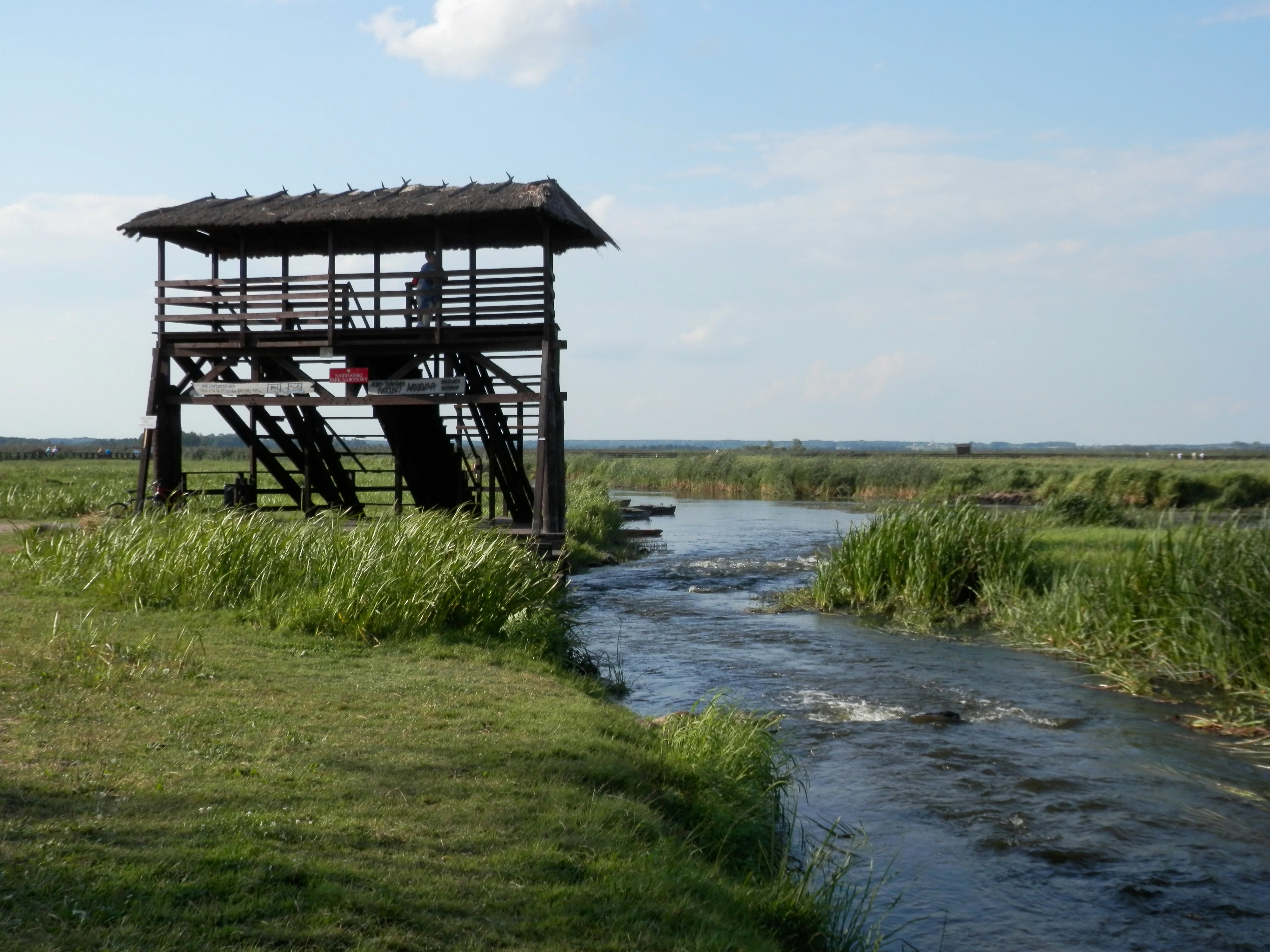
A wooden bird watching tower with a thatched roof stands beside a flowing river in a marshy landscape.
A wooden observation tower overlooking the Narew River in Waniewo.

Narwiański Park Narodowy ecosystems, habitats, and plant life

The protected area hosts a remarkably complex mosaic of wetland habitats that has developed through the interaction of natural river dynamics and centuries of human land management. The vegetation is dominated by large sedge communities, reed beds, willow scrub, and alder carrs along wetter ground, while mineral mounds carry oak-hornbeam woodland patches, dry meadows, and tall herb fringe communities. Approximately 58 distinct plant communities have been identified within the park's boundaries.

This habitat patchwork is largely the product of traditional hay-making on water meadows, a practice that has prevented scrub encroachment and maintained the open character that many wetland species depend on. Changes in land use, drainage, or abandonment of mowing therefore have a direct impact on the park's ecological balance, underscoring how closely the landscape's natural values are tied to its continuing cultural management.

Flora recorded in the park includes around 500 vascular plant species. Among these are several protected and noteworthy species, including white water lily, Siberian iris, tiled gladiolus, narrow-leaved gentian, large pink, round-leaved sundew, pole cat's-tail, common columbine, several orchid species, and juniper and fir clubmosses. The presence of these species reflects the diversity of microsites, from open water and floating vegetation to mineral mounds and wet forest.
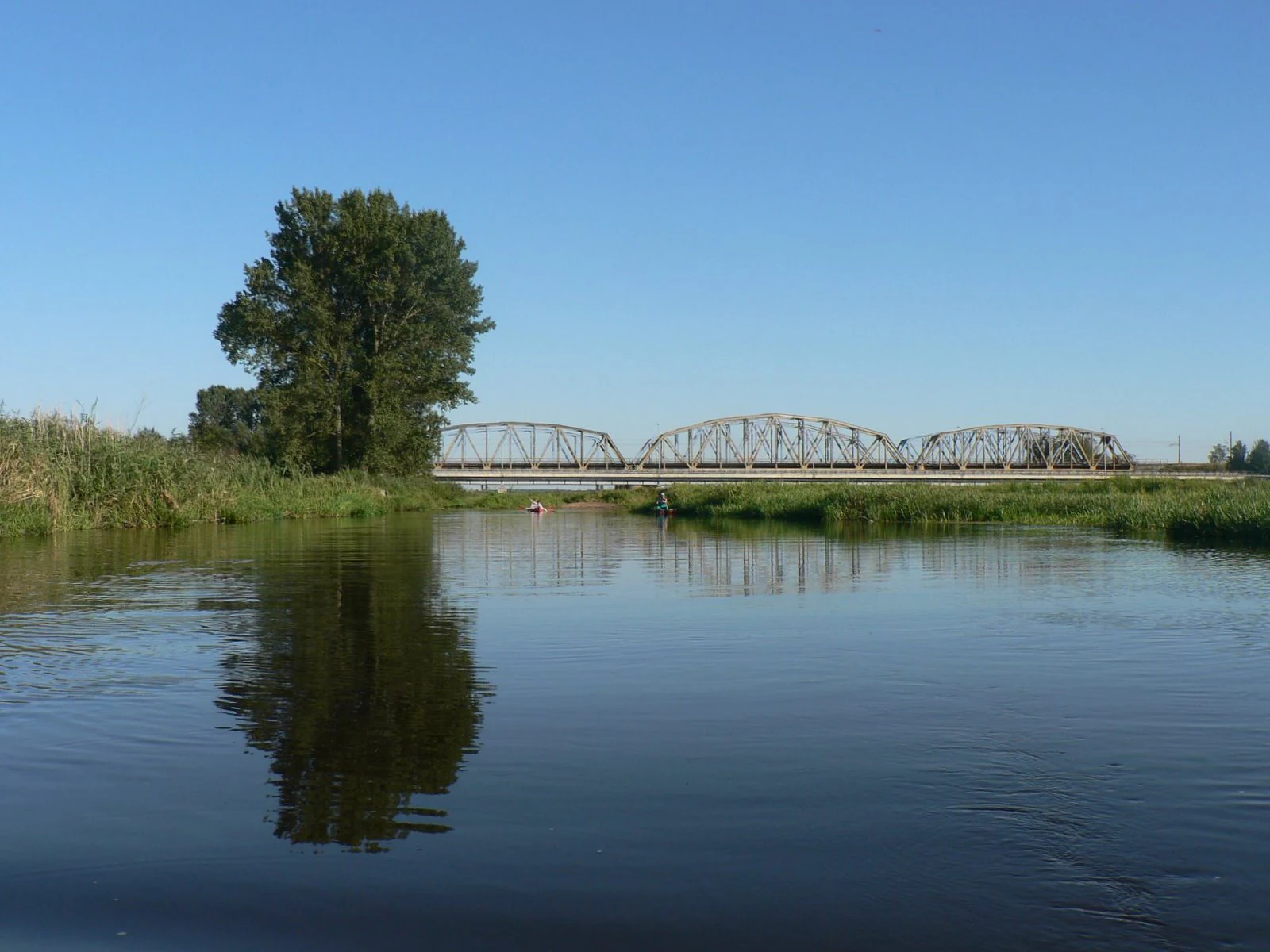
A wide view of the Narew River with a metal truss bridge crossing it in the distance; a large tree stands on the grassy bank in the foreground.
The Narew River flowing under a truss bridge in Uhowo.

Narwiański Park Narodowy wildlife and species highlights

Narwiański Park Narodowy is one of Poland's most important strongholds for wetland wildlife. The floodplain supports a very rich bird community, and the entire Narew valley has been recognized as an Important Bird Area by BirdLife International. Between 1979 and 2000, observers documented more than 200 bird species in the park, of which over 150 are breeding species. Globally and regionally threatened species recorded here include bittern, ruff, corncrake, great snipe, spotted crake, little crake, short-eared owl, and the aquatic warbler, which is identified as a key species for the area.

The park's mammal fauna includes around 34 species. Among the larger and most charismatic animals are European bison in the broader region, red deer, moose, roe deer, and wild boar, together with smaller species such as beaver, muskrat, stoat, polecat, hedgehog, and several shrew species. The wetlands are also important habitat for European otter and for water shrew in the riparian zone.

Fish diversity includes 21 recorded species, three of which are protected: bitterling, loach, and common gudgeon, alongside the protected Ukrainian lamprey, which inhabits the river system. Amphibians are especially well represented, with 13 recorded species across the park's various aquatic habitats, including two newts and a suite of frogs and toads adapted to the seasonal flooding cycle.

Narwiański Park Narodowy conservation status and protection priorities

The conservation significance of Narwiański Park Narodowy lies in the preservation of a rare and highly threatened type of floodplain ecosystem. Anastomosing rivers, where water flows through multiple braided channels rather than a single incised bed, have become uncommon across Europe because of river regulation, drainage, and land-use change. The park protects one of the last extensive examples in the region.

Unusually, the park does not have a designated strict protection zone; instead, the entire area is managed under active and landscape protection regimes, reflecting the long history of human shaping of its meadows and riverbanks. This model blurs the classic strict-versus-active boundary, instead recognizing the landscape as a cultural-ecological continuum where traditional mowing remains essential to sustaining biodiversity.

Internationally, the park is recognized as an Important Bird Area, with the aquatic warbler highlighted as a key conservation priority species. The combination of protected core land, a substantial buffer zone, and traditional land management practices gives the park an outsized conservation role in maintaining wetland-dependent biodiversity across northeastern Poland and the wider Baltic region.

Narwiański Park Narodowy cultural meaning and human context

Narwiański Park Narodowy lies in a region with a long tradition of coexisting with water and wet meadows. The floodplain landscape has been shaped by generations of small-scale agricultural use, particularly seasonal hay-making on sedge-dominated meadows, a practice that not only produced winter fodder but also helped maintain the open mosaic that supports the park's biodiversity.

The area carries tangible reminders of this deeper history. The nineteenth-century manor at Kurowo, which once served as the park's administrative headquarters, now functions as an interpretation center for the natural and cultural heritage of the Narew valley. Nearby, the surviving embankment and bridge abutments of the old pre-war Białystok-Warsaw road are a reminder of how dramatically transport routes and settlement patterns have shifted across this once strategic lowland corridor.

Traditional boats known as pychówki, used historically to navigate the broad, shallow, and channel-rich Narew, today connect cultural heritage with visitor experience. Many of the same routes used by earlier generations of local fishermen and hay-cutters are now traveled by visitors seeking a quiet, contemplative encounter with the wetland landscape, sustaining the connection between people, craft, and place.

Top sights and standout views in Narwiański Park Narodowy

Among the strongest points of distinction for Narwiański Park Narodowy are its status as the only Polish national park without a strict-protection zone, its protection of an internationally significant anastomosing river system, and its recognition as an Important Bird Area with a globally important aquatic warbler population.

The park also stands out for its long wooden footbridge connecting Waniewo and Śliwno, its traditional pychówka boat routes that loop around the protected river, and the layered cultural landscape where meadows, marshes, mineral mounds, and historic manor houses are woven together.

Best time to visit Narwiański Park Narodowy

Given that the park is defined by water, plants, and birds rather than snow sports or dramatic seasonal color shifts, late spring and early summer are generally the most rewarding seasons for visitors. This is when water levels are still significant but vegetation is vibrant, reed beds and sedges are in full growth, and breeding birds are most active and vocal. Summer continues to offer rich wildlife observation, though mosquitoes and other wetland insects can be abundant near the channels and meadows.

Autumn brings quieter conditions, lower water levels in places, and migration movements of waterfowl, while winter offers a starkly different atmosphere, with frost, quieter birdlife, and frozen or partially frozen channels reshaping the visual character of the floodplain. Kayaking and pychówka routes are typically most enjoyable from late spring through early autumn, when water and weather conditions are most favorable.
Monthly climate preview

Long-term representative temperature and precipitation averages recorded at benchmark coordinates

Narwiański Park Narodowy Climate Normals and Annual Weather Patterns

Historical data records monthly temperature and precipitation rhythms across the representative coordinate for Narwiański Park Narodowy from 1991 to 2020. Reviewing the complete twelve-month climatology profile provides deeper insight into measured baseline environmental averages.
Annual mean7 °C
-5 °C19 °C
Jan-5°
Feb-4°
Mar
Apr
May13°
Jun17°
Jul19°
Aug19°
Sep13°
Oct
Nov
Dec-3°
Warmest month
July

19.4 °C

Coolest month
January

-5 °C

Wettest month
July

2.6 mm/day

Driest month
March

1.3 mm/day

Park location guide

Geography guide, regional context, and park location map for Narwiański Park Narodowy

Narwiański Park Narodowy park geography, regions, and map view in Poland

Understand where Narwiański Park Narodowy sits in Poland through a broader geographic reading of the surrounding landscape, nearby location context, and its mapped position within the national park landscape.

How Narwiański Park Narodowy fits into Poland

Poland, officially the Republic of Poland, is a Central European country spanning from the Baltic Sea in the north to the Carpathian Mountains in the south. It borders Germany, Czech Republic, Slovakia, Ukraine, Belarus, Lithuania, and Kaliningrad Oblast. The country has a temperate climate, diverse landscapes, and is known for its rich history, cultural heritage, and strong economic position within the EU.

Wider geography shaping Narwiański Park Narodowy in Poland

Poland occupies 312,696 km2 in Central Europe, extending from the Baltic Sea coast in the north to the Sudetes and Carpathian Mountains in the south. It borders Germany to the west, Czech Republic and Slovakia to the south, Ukraine and Belarus to the east, and Lithuania and Kaliningrad Oblast to the northeast. The landscape includes lowland plains, uplands, and mountain ranges.

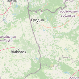
Map view of Narwiański Park Narodowy

Use this park location map to pinpoint Narwiański Park Narodowy in Poland, understand its exact geographic position, and read its mapped placement within the surrounding landscape more clearly.

Pigeon | © OpenStreetMap contributors

Location context for Narwiański Park Narodowy

Podlaskie Voivodeship
Natural feature types

Explore the Natural Landscapes and Geographic Features of Narwiański Park Narodowy

Continue your geographic research by accessing the full MoriAtlas index of named features for Narwiański Park Narodowy. Understand the spatial relationships between the river network, floodplain meadows, and mineral mounds that characterize this unique wetland environment through our structured data records.

Visual reference guide to wetland habitats, braided river channels, and protected floodplain terrain

Narwiański Park Narodowy Photos and Landscape Scenery

Visual documentation captures the unique anastomosing river network, broad reed beds, and shifting water channels defining Narwiański Park Narodowy. Photographic coverage illustrates the open lowland scenery, seasonally flooded meadows, and protected wetland habitats spanning the Narew valley.

A wide panoramic view of a long wooden boardwalk crossing a vast green wetland area under a bright sky with scattered clouds in Narew National Park.

An aerial shot of a winding river flowing through a vast, marshy wetland landscape in Poland.

A wooden bird watching tower with a thatched roof stands beside a flowing river in a marshy landscape.

A wide view of the Narew River with a metal truss bridge crossing it in the distance; a large tree stands on the grassy bank in the foreground.

Park atlas

Compare nearby national parks and wetland reserves across the surrounding region

Exploring Other Parks Near Narwiański Park Narodowy and Regional Protected Landscapes

Visitors exploring Narwiański Park Narodowy can continue discovering other national parks and protected areas within the surrounding region. Comparing adjacent lowland habitats and wetland reserves provides broader geographic context for regional conservation landscapes.
Watercolor painting showing a winding river through marshy fields with distant hills
National parkPodlaskie Voivodeship
Park boundaries overlap#1 closest

West

Narew National Park: Discover Poland's Premier Wetland National Park with Unique River Geography

Explore its mapped boundaries and rich protected landscape.

Narew National Park represents a significant protected area within the Podlaskie Voivodeship, distinguished by its one-of-a-kind anastomosing river system where the Narew River splits into numerous interconnected channels. This dynamic wetland environment provides critical habitat and showcases a complex interplay of water, land, and diverse ecosystems. Users can explore the park's geographic features, understand its protected landscape status, and appreciate its vital role within the regional atlas through detailed mapping and factual context.

Area
73.5 km²
Established
1996
IUCN
II
Relief
Lowland
Watercolor painting showing a wetland scene with reeds, patches of water, and trees under a light sky
National parkPodlaskie Voivodeship
17 km away#2 closest

North

Biebrza National Park: Protected Fenlands and River Basin Geography in Northeastern Poland

Tracing the largest lowland peat bog complex in the European landscape

Biebrza National Park serves as the premier protected wetland area in Poland, characterized by its vast, intact marshlands and the meandering Biebrza River valley. This geographic profile details the park's critical fen ecosystems, floodplain dynamics, and distinctive habitats that support diverse avian and mammalian populations within the Podlaskie region.

Area
592.23 km²
Established
1993
IUCN
II
Relief
Lowland
A watercolor painting of a flat wetland landscape with a winding river in the foreground, small clusters of trees, and rolling hills in the soft, distant background.
National parkPodlaskie Voivodeship
17 km away#3 closest

North

Biebrzański Park Narodowy: A Protected Wetland Landscape in Podlaskie Voivodeship, Poland

Mapped river valley and peatland geography.

Located in the northeast of Poland, Biebrzański Park Narodowy protects a sprawling, flat basin defined by the slow-meandering Biebrza River. This critical protected area encompasses rare peat bogs, floodplain meadows, and alder carrs, functioning as a vital refuge for wetland species within the broader Podlaskie Voivodeship landscape.

Area
592.23 km²
Established
1993
Visitors
23.2K annual
Relief
Lowland
Nature reservePodlaskie Voivodeship
About 24 km away#4 closest

West

Rezerwat przyrody Bagno Wizna II: Protected Peatland and Bog Terrain in Podlaskie Voivodeship

Mapped nature reserve and raised bog geography in northeastern Poland.

Rezerwat przyrody Bagno Wizna II functions as a specialized nature reserve in the Kotlina Biebrzańska, protecting rare raised bog vegetation. The site illustrates the intersection of active conservation efforts and regional drainage history, serving as a distinct geographic landmark within the wider protected land network of Podlaskie Voivodeship.

Area
0.796 km²
Established
1967
Relief
Lowland
Climate
Temperate
Nature reservePodlaskie Voivodeship
About 38 km away#5 closest

East

Bahno w Borkach Nature Reserve: Mapping the Boreal Peatland Landscapes of Podlaskie

A study of protected mire habitats and forest mosaics

Bahno w Borkach Nature Reserve protects a vital boreal-influenced peatland habitat within the larger Knyszyn Forest complex. The mapped landscape includes a complex mosaic of low-mire communities and forest patches that serve as an important reference site for ecological studies of the eastern Polish lowlands.

Area
2.899 km²
Established
1990
Relief
Lowland
Climate
Boreal
A soft watercolor painting showing a panoramic view of a lush, green landscape with a winding stream, distant hills, and trees against a pale, warm sky.
Nature reservePodlaskie Voivodeship
About 40 km away#6 closest

Northeast

Rezerwat przyrody Międzyrzecze: Exploring Protected Woodland Geography in Poland

A detailed geographic look at forest protection in the Knyszyn Forest landscape.

Deepen your understanding of Rezerwat przyrody Międzyrzecze through a focused study of its protected terrain. This site covers the essential geography of the nature reserve, detailing how glacial landforms and internal springs create unique woodland conditions within the Podlaskie Voivodeship. Access mapped data to see how this protected fragment integrates into the broader Knyszyn Forest ecological network.

Area
2.508 km²
Established
1990
Relief
Upland
Scope
Terrestrial
A soft, light-toned watercolor painting of a lowland forest landscape with trees, meadows, and distant hills.
Protected areaPoland
41 km away#7 closest

Southeast

Puszcza Białowieska Protected Area: Primeval Forest Geography and Mapped Boundaries

Ancient lowland forest landscapes of the Polish-Belarusian border

Examine the geographic composition of Puszcza Białowieska, an extensive primeval lowland forest characterized by multi-aged tree stands and abundant deadwood ecosystems. The area serves as a primary site for ecological research into natural forest regeneration and megafauna protection, specifically for the European bison and diverse predator populations living within its protected landscape boundaries.

Area
1,500 km²
Established
1932
Relief
Lowland
Climate
Temperate
Nature reservePodlaskie Voivodeship
About 46 km away#8 closest

West

Rezerwat przyrody Dębowe Góry: Protected Sessile Oak Forest in Podlaskie Voivodeship

Ecologically intact lowland forest and rare plant habitat

Rezerwat przyrody Dębowe Góry stands as a protected sanctuary for light-loving sessile oak communities in Podlaskie Voivodeship. Its rolling lowland terrain and rich understory flora represent an essential fragment of Poland's natural woodland heritage, functioning as a key study area within the broader Czerwony Bór forest landscape context.

Area
0.993 km²
Established
2001
Relief
Lowland
Scope
Terrestrial

Common questions about visiting, size, designation, and location context for Narwiański Park Narodowy

Narwiański Park Narodowy FAQs for park facts, access, geography, and protected area context

Find quick answers about Narwiański Park Narodowy, including protected-area facts, park geography, trail and visitor context, and how the park fits into its surrounding country and regional landscape.
MoriAtlas Explorer

Continue Your Protected Areas Search Across the Global Atlas

Deepen your exploration by continuing the structured search for national parks and protected areas worldwide. Utilize the comprehensive filtering capabilities to compare different conservation landscapes and refine your understanding of global park geography. Discover more about the distribution and characteristics of protected natural areas.

Global natural geography