
Mori Atlas logo
Protected landscapeNaturpark Habichtswald

Mapping the wooded Mittelgebirge and cultural heritage sites of the central German highlands.

Naturpark Habichtswald: An Atlas of Protected Landscapes and Basalt Ridges in Northern Hesse

Naturpark Habichtswald serves as a key protected landscape in northern Hesse, defined by the extensive beech and spruce forests of the Habichtswälder Bergland. This atlas entry details the geography of the park, covering its dramatic basalt summits, isolated Inselberge, and the dense cluster of medieval castle ruins and prehistoric ringwalls that shape the terrain. Spanning the ridges west of Kassel, the park provides a complex mosaic of volcanic rock outcrops and incised river valleys that characterize this significant central German highland region.

low mountain rangebeech forestMittelgebirgebasalt landscapeInselbergemedieval castle ruins
A flat-style digital illustration of a valley with tall mountains, a central waterfall flowing into a river, evergreen forests, and fields under a soft pink sunset sky.

Naturpark Habichtswald

Protected landscape

Park overview

Structured park overview, official facts, and landscape profile for Naturpark Habichtswald

Naturpark Habichtswald park facts, protected area profile, and essential visitor context

Review the core facts for Naturpark Habichtswald, including designation, size, terrain, visitor scale, habitats, and operating context in one park-focused overview.

About Naturpark Habichtswald

Naturpark Habichtswald is a designated protected recreation and landscape area in the German state of Hesse. Covering roughly 474 square kilometers, it lies mainly west and southwest of Kassel, following the contours of the Habichtswälder Bergland, the northeastern spur of the broader Westhessisches Bergland. The protected area extends into northern parts of the Schwalm-Eder-Kreis and is bordered to the east and southeast by the Kassel Basin, the Fulda valley, and the wooded ridges of Kaufunger Wald and Söhre, while to the south and west it drops toward the Eder and Diemel valleys.

The landscape is dominated by ridges and summits of the so-called Mittleres and Hohes Habichtswald, the Langenberge, the Dörnberg and Schreckenberge group, and the Hinterhabichtswälder Kuppen, with isolated Inselberge such as the Isthaberg and the Weidelsberg rising conspicuously above the surrounding terrain. The highest peak within the park is Hohes Gras at about 615 meters above sea level, followed by the heavily forested Großer Bärenberg. Many of the ridges carry expansive beech and mixed forests; basaltic summits such as the Hohe Dörnberg stand out as open plateaus with prehistoric ringwalls and long-distance views.

Culturally, the park is anchored by Bergpark Wilhelmshöhe, the UNESCO-listed baroque park of Landgrave Carl and later Electors of Hesse, in which the monumental Hercules statue, the Wilhelmshöhe Palace, the Löwenburg, and a network of cascades and water features climb the western slope of the Hohen Habichtswald. Surrounding the park, an unusually dense trail of medieval fortifications survives: rock-cut and hilltop castles, often reduced to romantic ruins, including Weidelsburg, Schauenburg, Altenburg, Helfenberg, Falkenstein, Falkenberg, Malsburg, Gudenberg, and Igelsburg. Prehistoric sites such as the Neolithic Steinkammergrab von Züschen, megalithic burials, and Bronze Age ringworks add an older archaeological layer.

The park is well known for outdoor recreation. Long-distance trails such as the Habichtswaldsteig, Herkulesweg, Löwenweg, and Fulda-Diemel-Weg cross its ridges, while the Kassel-Naumburg heritage railway, the Hessencourrier, threads its way through the southern park. Together, these features make Naturpark Habichtswald a signature example of a German Naturpark, integrating forest conservation, cultural heritage, and accessible outdoor recreation in the heart of Hesse.

Quick facts and research context for Naturpark Habichtswald

Naturpark Habichtswald is one of the designated nature parks (Naturparks) of the German state of Hesse. It was founded in 1962 and spans approximately 474 square kilometers across northern Hesse, primarily west of the city of Kassel. The park overlaps the Kassel district, portions of the city itself, and the Schwalm-Eder-Kreis, and includes the Habichtswälder Bergland, the locally known core hill range of the Westhessisches Bergland. Its highest point is Hohes Gras at about 615 meters above sea level. The park contains the UNESCO World Heritage Site Bergpark Wilhelmshöhe and an unusually dense cluster of ruined medieval castles, monasteries, and prehistoric monuments.

Protection and recognition

Terrestrial conservation framework and documented recognition details

Naturpark Habichtswald Protection Status and Official Designation Data

Naturpark Habichtswald maintains a defined terrestrial protection scope within the regional conservation network. Documented status data outlines the formal administrative framework and international recognition parameters associated with this landscape.

Protection details

Protection scope
Terrestrial
Transboundary protection
No
Park context

Deeper park guide and search-rich context for Naturpark Habichtswald

Naturpark Habichtswald history, landscape, wildlife, and travel context

Explore Naturpark Habichtswald through its history, landscape character, ecosystems, wildlife, conservation priorities, cultural context, and seasonal travel timing in a structured park guide built for atlas discovery and search intent.

Why Naturpark Habichtswald stands out

Naturpark Habichtswald is best known as the setting for the Bergpark Wilhelmshöhe, the dramatic baroque landscape park crowned by the Hercules monument and incorporating Schloss Wilhelmshöhe and the famous Kassel water cascades (Wasserspiele). The park is equally renowned among hikers and cultural historians for its exceptionally dense collection of medieval castle ruins, including the Weidelsburg, Schauenburg, Altenburg, and the Gudenberg, Malsburg, and Helfenberg ruins, set across heavily forested basalt and sandstone ridges. It is also recognized as a textbook example of a Hesse-style Naturpark, where recreational landscapes, prehistoric sites such as the Steinkammergrab von Züschen, and ongoing rural land use blend with protected woodland above the Fulda, Eder, and Diemel river valleys.
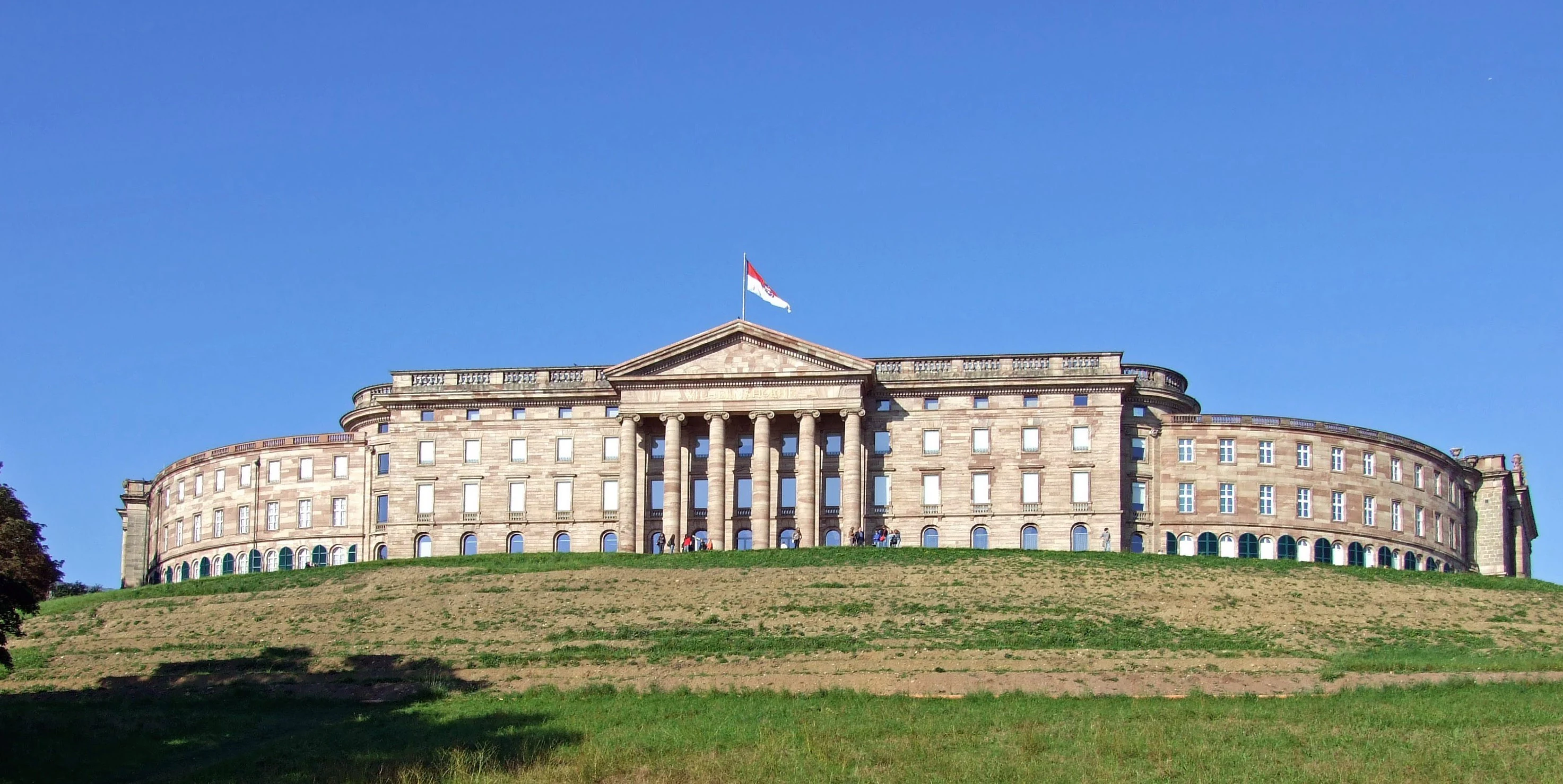
A wide, eye-level shot of the large, neoclassical Schloss Wilhelmshöhe palace, showing its curved wings and central pedimented portico atop a grassy hill under a clear blue sky.
Schloss Wilhelmshöhe, a neoclassical palace located within the Bergpark Wilhelmshöhe area of Naturpark Habichtswald.

Naturpark Habichtswald history and protected-area timeline

The hills and ridges of the Habichtswald have been inhabited and transformed by people for thousands of years. Archaeological finds, including ringwalls and megalithic tombs, document human activity from the Neolithic period onward, with evidence from sites such as the Steinkammergrab von Züschen dating settlement to roughly 5000 BC. Bronze Age and Iron Age hilltop enclosures, including the ringwalls on the Hohen Dörnberg and on the Bilstein and Burgberg in the Langenberge, show that the landscape was used as a place of refuge, ritual, and control long before any written records.

During the Middle Ages, the region's mix of commanding basalt and sandstone summits and narrow river valleys favored the construction of castles and small towns. Numerous hilltop castles, including Schauenburg, Weidelsburg, Altenburg, Helfenberg, Gudenberg, Falkenberg, Falkenstein, Malsburg, and Igelsburg, were erected on the most defensible positions, several of them founded by the Landgraves of Hesse and the Archbishops of Mainz. Today most survive only as ruins, but they remain conspicuous features of the landscape and give the park its distinctive silhouette of medieval fortifications above wooded valleys.

In the eighteenth century, Landgrave Carl of Hesse-Kassel began transforming the western slope above Kassel into the Bergpark Wilhelmshöhe, a baroque and later English-style landscape park framed by the Hercules monument and Schloss Wilhelmshöhe. The park was further embellished by successive rulers and eventually recognized as a UNESCO World Heritage Site in 2013.

Modern conservation and recreational planning began with the establishment of Naturpark Habichtswald in 1962, an early example of the German Naturpark movement designed to combine landscape protection, environmental education, and rural development. A dedicated Naturparkzentrum was opened near the Hohen Dörnberg in 2009, providing visitor information on geology, natural history, and cultural heritage for several decades until it closed permanently at the end of 2023.

Naturpark Habichtswald landscape and geographic character

The landscape of Naturpark Habichtswald is fundamentally shaped by the Habichtswälder Bergland, a forested Mittelgebirge that sits at the northeastern edge of the Westhessisches Bergland. Its surface is dominated by broad, often heavily wooded ridges and summits separated by deeply incised valleys. Most of the highest ground, including the Hohen Habichtswald, the Langenberge, the Großer Bärenberg, and the Isthaberg, is capped by basalt or similar volcanic rocks, producing blocky hilltops, rocky outliers, and Inselberge that rise abruptly from gentler slopes. The Hohe Dörnberg, a partially unforested basalt plateau crowned by an extensive prehistoric ringwall, opens up particularly wide views over the surrounding lowlands.

The park's terrain steps down to the north toward the Diemel valley, to the east toward the Kassel Basin and the Fulda river, and to the south toward the Eder valley. In the west, the relief flattens into the so-called Stadtwälder between Naumburg and Wolfhagen, while singular spurs such as the Weidelsberg, Burghasunger Berg, and the Isthaberg rise as isolated Inselberge above the surrounding wooded lowlands. This transition between high forest ridges and open river valleys creates a varied mosaic of closed canopy forest, open basalt hilltops, gentle agricultural valleys, and deeply cut stream corridors.

Several notable geomorphological features stand out within the park: the Hohle Stein on the Hohe Dörnberg, a prehistoric cult site surrounded by a ringwall; the Hoofer Pforte, a narrow landscape gateway between the Hohen Habichtswald and the Langenberge; and summit viewpoints such as Hohes Gras, the Großer Bärenberg with the Bärenbergturm, the Elfbuchen tower, and the Brasselsberg with its Bismarck monument. Together these landforms give the Habichtswald its recognized scenic character of wooded ridges punctuated by lookout-bearing summits and isolated castle-bearing Inselberge.
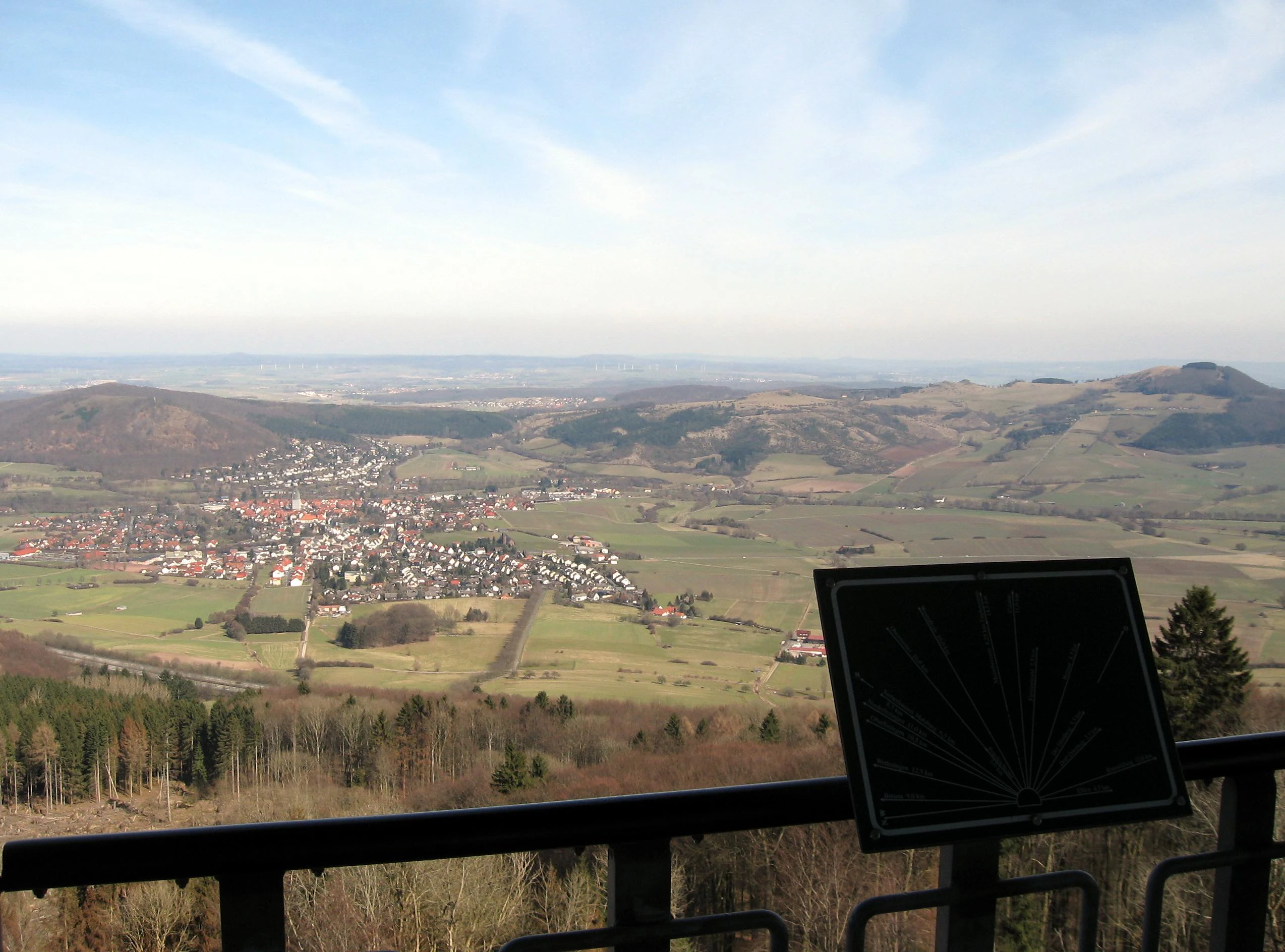
High angle view from an observation deck looking out over a small town nestled in a valley, with rolling forested hills in the background and a black metal orientation map on a railing in the foreground.
Panoramic view over the town of Zierenberg from the observation tower on Großer Bärenberg.

Naturpark Habichtswald ecosystems, habitats, and plant life

Ecologically, Naturpark Habichtswald sits in the transition zone between the Westhessisches Bergland and the northern Hessian lowlands, with forests as the dominant habitat. Extensive beech woods of the Hohen Habichtswald, mixed deciduous stands on the slopes of the Langenberge, and conifer plantations in the western Stadtwälder between Naumburg and Wolfhagen form the principal vegetation cover. Where basalt caps the summits, soil conditions often produce lighter, more open woodlands, sometimes grading into bush-rich plateaus and natural open space, as on parts of the Hohen Dörnberg, the Brasselsberg, and the Burghasunger Berg.

The park lies above the upper reaches and tributaries of several important central German rivers. Streams such as the Bauna, Drusel, Ahne, and Dusebach feed the Fulda system; the Ems, Elbe, and Warme drain into the Eder and Diemel, while the Erpe and Mühlenwasser flow toward the Twiste. These small to medium-sized valleys shelter narrow gallery forests, springs, and small stillwaters including the Hangarsteinsee, the Silbersee near the Dörnberg, and the Sichelbachbecken high in the Hohen Habichtswald. The Bergpark Wilhelmshöhe includes constructed waters such as the Lac, the Fontaineteich, and the Asch, which are heavily modified but visually and ecologically significant.

Beyond forest habitats, the park contains smaller protected features and habitats by virtue of its varied geology and land use history. Nature reserve (NSG) areas include the Festberg bei Philippinenthal near Wolfhagen, and steep valley slopes, boulder fields, and prehistoric earthworks such as those on the Hohen Dörnberg and the Bilstein support mosaic habitats of dry grassland, scrub, and rock communities alongside closed forest.
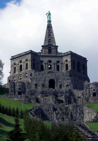
A low-angle, full view of the stone Hercules Monument, featuring an octagonal structure topped by a spire and a statue, built upon a rugged grotto-like foundation surrounded by green parkland.
The Hercules Monument at Bergpark Wilhelmshöhe, a iconic landmark within Naturpark Habichtswald.

Naturpark Habichtswald wildlife and species highlights

Because the source material focuses on landscape, heritage, and recreation rather than on fauna, specific wildlife species listings are limited. The park nevertheless supports typical central German low-mountain wildlife, with the extensive beech and mixed forests of the Habichtswald providing habitat for deer and wild boar, and the mosaic of forest edge and open basalt plateaus such as the Hohen Dörnberg offering conditions for smaller game, woodland birds, and typical species of Hessen woodland and edge habitats.

Water-related habitats, including the upper Fulda, Eder, and Diemel tributaries, the small constructed lakes of Bergpark Wilhelmshöhe, and ponds such as the Silbersee and Bendersee, contribute freshwater habitats for fish, amphibians, and water birds. The park's dense forest cover, combined with traditional cultural landscape elements such as hedgerows, valley meadows, and castle-ruin rock outcrops, supports a varied bird community of woodland, edge, and open-ground species typical of the northern Hessian Mittelgebirge.
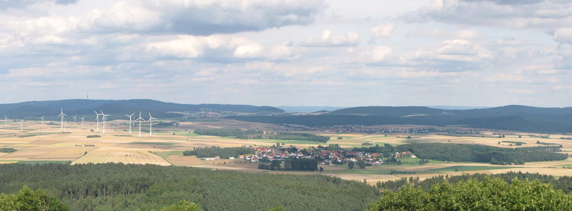
A wide, elevated landscape view featuring rolling hills covered in dense forest, interspersed with agricultural fields and a small village, with wind turbines visible in the middle distance under a cloudy sky.
Panoramic view over the Hoofer Pforte valley and the forested hills of the Habichtswald region as seen from Weidelsburg.

Naturpark Habichtswald conservation status and protection priorities

Naturpark Habichtswald is one of the official Naturparks of Hesse and part of Germany's broader network of nature parks designed to balance landscape protection, ecological management, biodiversity conservation, and sustainable outdoor recreation. Established in 1962, it is among the older generation of German Naturparks and serves as a regional model for combining the protection of large forested landscapes with the preservation of cultural heritage and the support of regional tourism.

Conservation values include the protection of extensive beech-dominated woodland in the Habichtswälder Bergland and Langenberge, the preservation of distinct basalt-block habitats on summits such as the Hohen Dörnberg, Hohes Gras, Großer Bärenberg, and the isolated Inselberge, and the safeguarding of small protected nature reserves, for example the Festberg bei Philippinenthal. The park also plays a role in protecting and interpreting notable geological and geomorphological features, including basalt caprock landscapes, narrow valley systems, and culturally protected prehistoric sites such as the Steinkammergrab von Züschen and the ringwalls of the Hohen Dörnberg and Bilstein.

The presence of the UNESCO World Heritage Site Bergpark Wilhelmshöhe inside the protected area gives the park an additional dimension of conservation stewardship, requiring sensitive management of the surrounding forests, water systems, and viewpoints that frame the baroque landscape park. The park's visitor center near the Hohen Dörnberg, which operated from 2009 until late 2023, supported environmental education and visitor information as part of the broader conservation strategy.

Naturpark Habichtswald cultural meaning and human context

The Habichtswald is a long-inhabited cultural landscape. From the Neolithic period onward, its ridges and summits have hosted settlements, burials, cult sites, and defensive works; visible traces include the Steinkammergrab von Züschen megalithic tomb, multiple ringwalls on the Hohen Dörnberg, Bilstein, Burgberg, and Hunrodsberg, and a network of medieval hilltop castles.

The era of the Hessian Landgraves left the park its most iconic cultural feature, the baroque Bergpark Wilhelmshöhe with its Hercules monument, water cascades, Wilhelmshöhe Palace, and Löwenburg stronghold, now a UNESCO World Heritage Site. Romantic-era interest in ruined castles reinforced the park's identity as a landscape of picturesque medieval ruins, while local communities such as Bad Emstal, Wolfhagen, Zierenberg, Naumburg, and Volkmarsen maintain traditional timber-framed heritage villages connected to the region's identity as part of the Deutsche Fachwerkstraße and Deutsche Märchenstraße tourist routes.

Top sights and standout views in Naturpark Habichtswald

Naturpark Habichtswald's most distinctive highlights include the UNESCO-listed Bergpark Wilhelmshöhe with its Hercules monument, Wilhelmshöhe Palace, Löwenburg, and baroque water cascades set high above Kassel; the broad forested ridges of the Hohen Habichtswald and Langenberge; the basalt plateau of the Hohen Dörnberg with its prehistoric ringwall; the Inselberge of Isthaberg and Weidelsburg; and an exceptional cluster of medieval hilltop castle ruins such as Schauenburg, Weidelsburg, Altenburg, Gudenberg, Helfenberg, and Falkenstein. Long-distance trails like the Habichtswaldsteig and Herkulesweg, together with the museum railway Hessencourrier, link these highlights across the Hessencourrier-Radweg cycling route.

Best time to visit Naturpark Habichtswald

The park's strong forest and ridge character makes summer and early autumn particularly attractive for walking, with the deciduous canopy shaping shaded valleys and the open basalt summits such as Hohes Gras, the Hohen Dörnberg, and the Großer Bärenberg offering panoramic views. Late spring brings fresh beech foliage across the ridges, while autumn highlights the beech and mixed forests in warm seasonal color. Winter can also be rewarding, with the park's lower terrain occasionally dusted with snow and outlook towers such as the Bärenbergturm and Elfbuchen offering crisp views, though conditions at higher elevations can be harsh, and the heritage railway Hessencourrier operates only seasonally. As with any northern German Mittelgebirge, weather on the summits can change quickly, so visitors should plan for cooler and wetter conditions even in summer.

Monthly climate preview

Long-term temperature and precipitation records measured at representative coordinate points

Naturpark Habichtswald Climate Normals and Annual Weather Patterns

Naturpark Habichtswald displays a measured annual temperature rhythm ranging from sub-zero winter minimums to warm summer maximums alongside consistent monthly precipitation. Detailed monthly climate normals provide a complete analytical breakdown of long-term meteorological trends across the protected area.
Annual mean9 °C
-1 °C19 °C
Jan-1°
Feb
Mar
Apr
May12°
Jun16°
Jul19°
Aug18°
Sep14°
Oct
Nov
Dec
Warmest month
July

18.6 °C

Coolest month
January

-0.8 °C

Wettest month
July

2.5 mm/day

Driest month
April

1.4 mm/day

Park location guide

Geography guide, regional context, and park location map for Naturpark Habichtswald

Naturpark Habichtswald park geography, regions, and map view in Germany

Understand where Naturpark Habichtswald sits in Germany through a broader geographic reading of the surrounding landscape, nearby location context, and its mapped position within the national park landscape.

How Naturpark Habichtswald fits into Germany

Germany is a federal republic in Western and Central Europe with a population of over 83 million across sixteen constituent states. It is Europe's largest economy by nominal GDP and a major global exporter and importer. The capital is Berlin, and the country borders Denmark, Poland, Czech Republic, Austria, Switzerland, France, Luxembourg, Belgium, and the Netherlands.

Wider geography shaping Naturpark Habichtswald in Germany

Germany is located in Western and Central Europe, spanning 357,022 km². It borders Denmark to the north, Poland and the Czech Republic to the east, Austria and Switzerland to the south, and France, Luxembourg, Belgium, and the Netherlands to the west. The country has coastlines on the Baltic Sea and North Sea to the north, with the Alps located in the southern region.

Map view of Naturpark Habichtswald

Use this park location map to pinpoint Naturpark Habichtswald in Germany, understand its exact geographic position, and read its mapped placement within the surrounding landscape more clearly.

Pigeon | © OpenStreetMap contributors

Location context for Naturpark Habichtswald

Hesse

Visual exploration of forested Mittelgebirge ridges, basalt outcrops, and historic monuments

Naturpark Habichtswald Photos, Scenery, and Protected Landscape Views

Visual records reveal the diverse terrain and wooded habitats defining Naturpark Habichtswald across northern Hesse. Detailed photography illustrates the region's volcanic crests, rolling valleys, and prominent cultural landmarks.

A wide, eye-level shot of the large, neoclassical Schloss Wilhelmshöhe palace, showing its curved wings and central pedimented portico atop a grassy hill under a clear blue sky.

A low angle shot of the weathered stone ruins of a castle tower, specifically the East Palas of Weidelsburg, with a small flag flying at the top against a blue sky.

High angle view from an observation deck looking out over a small town nestled in a valley, with rolling forested hills in the background and a black metal orientation map on a railing in the foreground.

A low-angle, full view of the stone Hercules Monument, featuring an octagonal structure topped by a spire and a statue, built upon a rugged grotto-like foundation surrounded by green parkland.

A wide, elevated landscape view featuring rolling hills covered in dense forest, interspersed with agricultural fields and a small village, with wind turbines visible in the middle distance under a cloudy sky.

A rural landscape showing a field with yellow flowers in the foreground, transitioning to green pastures, dense deciduous and coniferous forests in the midground, and layered rolling hills in the background under a pale sky.

Park atlas

Compare regional Mittelgebirge geography and adjacent conservation zones

Explore Parks Near Naturpark Habichtswald and Surrounding Protected Landscapes

Browsing other protected areas near Naturpark Habichtswald reveals similar forested ridges, basalt landforms, and river valley corridors across northern Hesse. Comparing these adjacent regional landscapes expands geographic context and connects wooded hill country across the broader territory.
A pale watercolor painting showing a rolling landscape with soft green hills, scattered trees, and a hazy mountain silhouette against a white background.
Nature reserveHesse
About 5.7 km away#1 closest

Northwest

Auf den Hesseln bei Naumburg Nature Reserve: Protected Landscape and Geography Atlas

A calcareous grassland mosaic within the Kassel district of Hesse

This protected area in northern Hesse encompasses a complex relief of Triassic mussel limestone slopes and alluvial woodland. The site highlights the importance of managed limestone dry grasslands and former quarry habitats in supporting specialized flora, serving as a concentrated example of habitat diversity within the surrounding agricultural landscape.

Area
0.196 km²
Established
1996
Relief
Upland
Climate
Temperate
Watercolor painting of a soft, rolling landscape with green fields, distant hills, and low foreground vegetation.
Protected areaGermany
About 8.7 km away#2 closest

Northeast

Langenberger Huete bei Breitenbach: Mapped Geography and Protected Area Landscape Context

Nature reserve terrain and grassland boundaries in northern Hesse

Examine the geographic layout of Langenberger Huete bei Breitenbach, a protected dry grassland area near Schauenburg, Germany. This site preserves open meadow habitats along the forested Langenberg ridge, offering insight into traditional land use and small-scale conservation within the Habichtswald region. Access detailed boundary data and terrain information to understand its position within the surrounding agricultural and woodland zones.

Area
0.14 km²
Established
1992
Relief
Upland
Climate
Temperate
Watercolor painting showing a landscape with hills, forest, and a body of water
National parkHesse
About 12 km away#3 closest

West

Kellerwald-Edersee National Park: Hesse's Protected Landscape Exploration

Mapped boundaries and geographic context for this German national park.

Navigate the protected landscape of Kellerwald-Edersee National Park, a key national park situated in the German state of Hesse. This atlas entry focuses on its precise geographic definition, mapped terrain features, and the broader regional context it occupies within central Germany. Gain structured insights into the park's conservation significance and its place in the mapped landscape.

Area
76.88 km²
Established
2004
IUCN
II
Relief
Highland
A horizontal watercolor painting depicting a calm wetland landscape with soft green trees, grassy banks, and rolling hills in the background.
Nature reserveHesse
About 13 km away#4 closest

North

Glockenborn bei Bründersen Nature Reserve: Regional Geography and Wetland Protected Areas

A mapped overview of wetland terrain in northern Hesse

Glockenborn bei Bründersen offers a focused look at how managed wetlands integrate into the agricultural landscape of northern Hesse. Known for its distinct shallow lakes and bird-rich environments, this nature reserve serves as an essential case study in ecological restoration and the maintenance of open grazing lands within a protected boundary.

Area
0.07 km²
Established
2004
Watercolor painting of a rolling forested landscape with distant hills under a soft light.
Nature reserveHesse
About 15 km away#5 closest

North

Erlebach bei Ehlen Nature Reserve: Protected Terrain and Brook Valley Geography in Hesse

Mapped beech forest mosaic and riparian habitat corridors

Located in the Hoher Habichtswald, Erlebach bei Ehlen preserves a distinctive transition between mature beech forest and open grassland valley. This nature reserve serves as an essential case study for understanding riparian ecology, stream-side woodland distribution, and habitat connectivity within the regional topography of Hesse, Germany.

Area
0.342 km²
Established
1996
A soft watercolor painting depicting rolling green hills against a faint, light-colored background.
Nature reserveHessen
About 15 km away#6 closest

North

Festberg bei Philippinenthal Nature Reserve: Geography and Protected Landscape Context

A rare calcareous grassland ecosystem in northern Hessen.

Festberg bei Philippinenthal encompasses a ridge of tilted Muschelkalk limestone rising above the Lohbach stream in Hessen. This nature reserve protects a vital combination of juniper heath, dry calcareous grassland, and small-scale forest habitats maintained by historic and modern conservation grazing, offering a clear example of local geology shaping biodiversity.

Area
0.143 km²
Established
1992
IUCN
IV
A watercolor painting in soft pastel tones showing a winding river or path flanked by small clusters of green trees, with gently rolling hills in the background against a white backdrop.
Nature reserveKassel
About 15 km away#7 closest

Northeast

Dönche Nature Reserve: Investigating the Protected Landscapes and Urban Geography of Kassel

Exploring the historic grassland and wetland mosaic in northern Hesse

Dönche serves as a primary example of an inner-city nature reserve in Germany, preserving 170 hectares of open countryside within the Kassel urban fabric. Its landscape is shaped by the Dönchebach and Krebsbach streams, forming a rhythmic structure of ponds, beech wood pastures, and tall herb communities that offer a deep look into regional ecology and historical land use.

Area
1.709 km²
Established
1983
Water
Minor water
A watercolor painting showing a tranquil lake shore with soft green vegetation and distant muted hills.
Nature reserveSchwalm-Eder-Kreis
About 17 km away#8 closest

South

Borkener See Nature Reserve: Geographic Overview of a Reclaimed Wetland and Bird Sanctuary

A protected landscape featuring oligotrophic lake waters in Schwalm-Eder-Kreis.

Borkener See serves as a focal point for understanding the reclamation of mining landscapes in northern Germany. As an officially protected nature reserve, it provides a stable habitat for migratory bird species, with deep water basins and carefully managed wetland buffers defining its physical and ecological presence in the Westhessische Senke.

Area
3.5 km²
Established
1990
Relief
Lowland
Climate
Temperate

Common questions about visiting, size, designation, and location context for Naturpark Habichtswald

Naturpark Habichtswald FAQs for park facts, access, geography, and protected area context

Find quick answers about Naturpark Habichtswald, including protected-area facts, park geography, trail and visitor context, and how the park fits into its surrounding country and regional landscape.
MoriAtlas Explorer

Continue Your Protected Areas Search Across the Global Atlas

Deepen your exploration by continuing the structured search for national parks and protected areas worldwide. Utilize the comprehensive filtering capabilities to compare different conservation landscapes and refine your understanding of global park geography. Discover more about the distribution and characteristics of protected natural areas.

Global natural geography