Mori Atlas logo
Nature reserveNaturschutzgebiet Ostenberg

Geographic analysis of the multi-level Ostenberg cave system and hillside forest terrain

Naturschutzgebiet Ostenberg: Mapped Boundaries, Limestone Caves, and Upland Forest Landscapes

Located on the southern slopes of the 566-meter Ostenberg hill in Hochsauerlandkreis, this nature reserve protects a vital intersection of beech and spruce woodland with a 622-meter karst cave network. The reserve provides a distinct geographic window into the Sauerland landscape, where a disused quarry reveals limestone structures that house important bat habitats. This protected area stands as a unique site within the Natura 2000 network for its preserved underground voids and steep upland slopes.

beech forestspruce forestlimestone cavekarst landscapequarrybat habitat

Naturschutzgebiet Ostenberg

Nature reserve

Park overview

Structured park overview, official facts, and landscape profile for Naturschutzgebiet Ostenberg

Naturschutzgebiet Ostenberg park facts, protected area profile, and essential visitor context

Review the core facts for Naturschutzgebiet Ostenberg, including designation, size, terrain, visitor scale, habitats, and operating context in one park-focused overview.

About Naturschutzgebiet Ostenberg

Naturschutzgebiet Ostenberg is a compact protected landscape in the northern Sauerland, a region of upland forests and small river valleys in the German state of North Rhine-Westphalia. The reserve covers the southern slopes of the Ostenberg hill near Bestwig and represents one of the many nature reserves established by the Hochsauerland district to conserve ecologically valuable forest stands and isolated geological features.

At the heart of the reserve lies the Ostenberg cave, a multi-level cavity with a total passage length of roughly 622 meters. The cave occupies a remarkably high position above the surrounding valley, making it an interesting example of high-elevation cave formation. It was discovered only in 1991, when quarrying work on the western flank of the hill cut into the upper level of the cavity. That former quarry is now part of the protected area, with the cave entrance integrated into the nature reserve's eastern boundary.

The forest that surrounds and extends beyond the cave entrance is dominated by European beech and Norway spruce, a common but ecologically valuable canopy combination on the acidic soils of the Sauerland ridges. These shaded, humid slopes support rich communities of mosses, ferns, lichens, and woodland wildflowers, including species such as wood spurge, foxglove, and various delicate thallose and leafy liverworts documented for the site. The reserve's small size belies the diversity of microhabitats created by the interplay of slope, rock, and deeply shaded woodland.

The reserve carries both national and European designations. It has been formally protected as a Naturschutzgebiet since 2008, when it was written into the Bestwig landscape plan by the Hochsauerland district administration. Since 2004 it has also formed part of the European Habitats Directive site that consolidates several caves, mines, and tunnels around Bestwig and Olsberg into a single Natura 2000 area. This dual protection underscores both the local and international conservation significance of the Ostenberg cave and its surrounding forest.

Quick facts and research context for Naturschutzgebiet Ostenberg

Naturschutzgebiet Ostenberg lies south of Bestwig in the Hochsauerlandkreis district of North Rhine-Westphalia, covering approximately 21 hectares on the southern slopes of the Ostenberg hill, which rises to 566 meters. The site was designated as a nature reserve in 2008 through the Bestwig landscape plan and has been part of the Natura 2000 Habitats Directive site "Höhlen und Stollen bei Bestwig und Olsberg" since 2004.

The reserve centers on the Ostenberg cave system, a 622-meter multi-level limestone cavity discovered in 1991 during quarry operations and accessed from the western part of an abandoned quarry. Protection here combines beech and spruce forest preservation with safeguarding the cave environment as winter habitat for bats and as a rich habitat for mosses, ferns, and lichens typical of shaded, humid woodland.

Protection and recognition

Documented terrestrial conservation scope and recognition history

Naturschutzgebiet Ostenberg Protection Status and Designation Records

Terrestrial protection status records detail the conservation scope established for Naturschutzgebiet Ostenberg across available administrative sources. Official designation facts outline the documented management framework governing this protected natural landscape.

Protection details

Protection scope
Terrestrial
Transboundary protection
No
Park context

Deeper park guide and search-rich context for Naturschutzgebiet Ostenberg

Naturschutzgebiet Ostenberg history, landscape, wildlife, and travel context

Explore Naturschutzgebiet Ostenberg through its history, landscape character, ecosystems, wildlife, conservation priorities, cultural context, and seasonal travel timing in a structured park guide built for atlas discovery and search intent.

Why Naturschutzgebiet Ostenberg stands out

Naturschutzgebiet Ostenberg is best known for the Ostenberg cave, a multi-level cavity of 622 meters total passage length whose elevated position above the valley floor is geologically unusual. The cave was accidentally intersected during quarrying in 1991, and its preservation as part of a dedicated nature reserve reflects both its speleological and ecological importance. The reserve is also recognized for its steep hillside forests of European beech and Norway spruce, which together with the cave system created the basis for its inclusion in the European Natura 2000 network. The combination of a relatively undisturbed woodland on south-facing slopes and a hibernation cave for bat species gives the site a distinctive character among the many small nature reserves of the Sauerland region.
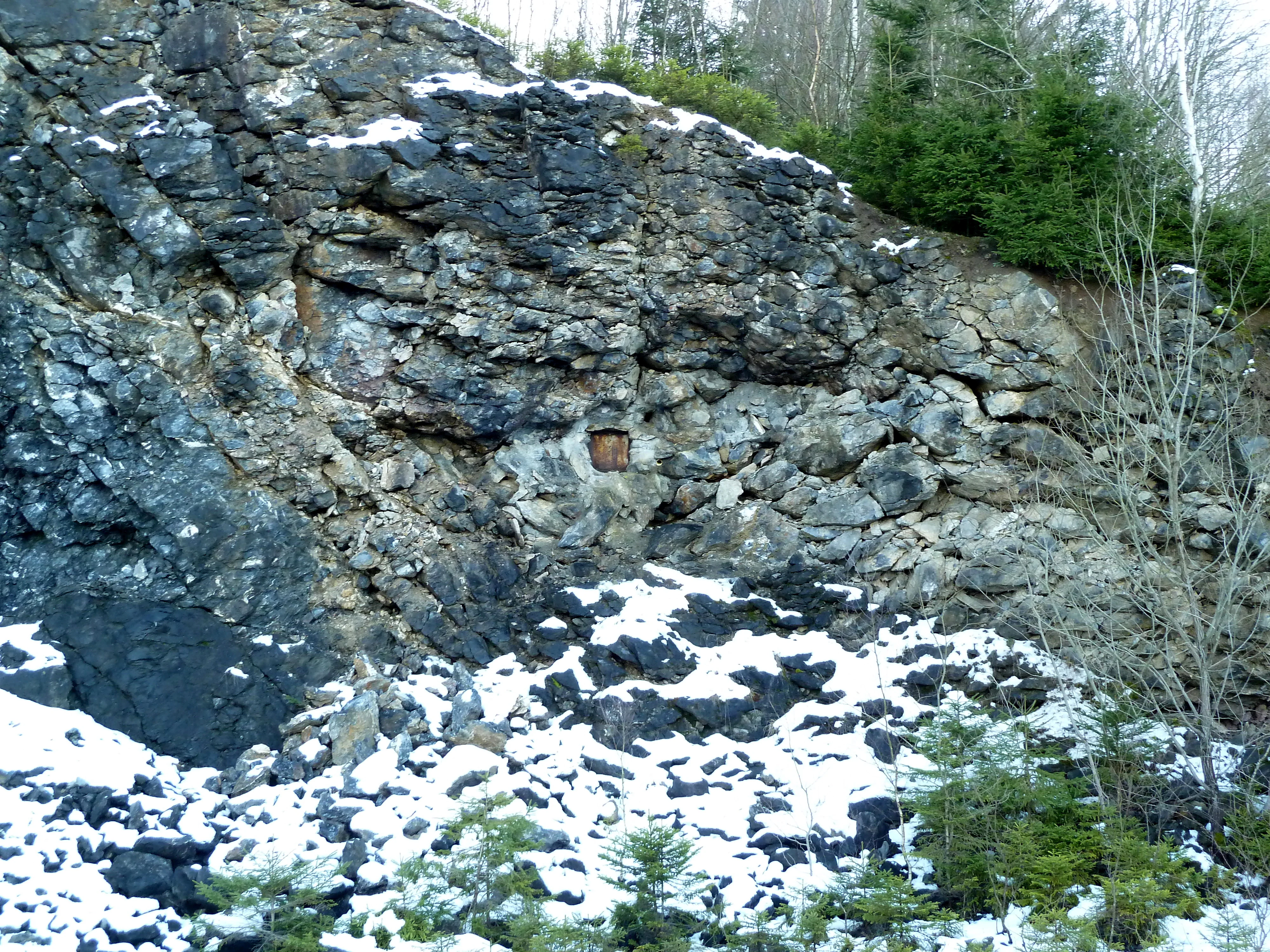
A gated, recessed entrance into a rocky cliff face, partially covered by snow and surrounded by coniferous trees.
The gated entrance to the Ostenberghöhle cave system within the Naturschutzgebiet Ostenberg.

Naturschutzgebiet Ostenberg history and protected-area timeline

The protected area around the Ostenberg hill evolved in stages, beginning with the geological and industrial activity that later made its conservation necessary. Quarrying on the western side of the hill opened a working face that in 1991 intersected the cave system now known as the Ostenberghöhle. The cavity, with its unusually high position above the valley floor, had apparently remained unknown until that point because its entrance was concealed within the rock face.

The cave quickly attracted speleological interest. A 1995 study published in the Speläologisches Jahrbuch documented speleothem formations within the cave, and a subsequent research project from the Ruhr University of Bochum's Institute for Geology, Mineralogy and Geophysics continued the scientific investigation of the site. These early studies helped establish the case for formal protection.

In 2004, the cave and its surrounding woodland were incorporated into the Fauna-Flora-Habitat site "Höhlen und Stollen bei Bestwig und Olsberg" under the European Union's Habitats Directive, giving the area its place in the Natura 2000 network. Four years later, in 2008, the Hochsauerlandkreis district formally designated the area as the Naturschutzgebiet Ostenberg through the landscape plan for the municipality of Bestwig. The designation expressly aimed to protect the woodland and the cave together with their associated species, citing the rarity, particular character, and beauty of the area as justification, which is the standard rationale applied to nature reserves in Germany.

Naturschutzgebiet Ostenberg landscape and geographic character

The landscape of the reserve is defined by the steep southern and southeastern slopes of the Ostenberg hill, an upland peak reaching 566 meters above sea level within the broader rolling terrain of the northern Sauerland. These slopes descend toward the Ruhr valley near Bestwig, creating an abrupt gradient between forested ridge and inhabited lowland.

The protected forest is dominated by mature stands of European beech and Norway spruce, characteristic of the region's mixed upland woodland. The steep, shaded hillside produces a cool, humid microclimate that supports moisture-loving ground flora, including ferns such as lady fern and broad buckler fern, woodland wildflowers, and an extensive moss and lichen community typical of old, undisturbed forest stands.

On the eastern edge of the reserve, the modern gentle terrain of the wooded slopes gives way to the abrupt vertical faces of a former quarry. The quarry exposes the underlying limestone in which the Ostenberg cave system developed, and its working levels now provide the only access to the cavity. From the quarry face, the cave extends in multiple levels for a total passage length of 622 meters, occupying a position unusually high above the surrounding valley floor and giving the landscape a distinctive combination of forested hill, exposed rock, and underground void.

Naturschutzgebiet Ostenberg ecosystems, habitats, and plant life

Ecologically, Naturschutzgebiet Ostenberg represents a relatively intact example of upland beech and spruce forest on steep, acid-soil slopes, a habitat type that remains characteristic of the northern Sauerland but has been heavily modified elsewhere. The closed canopy and shaded conditions create a stable, humid microclimate that has allowed a diverse community of bryophytes, ferns, and woodland herbs to persist.

The reserve belongs to the broader European Habitats Directive site covering caves, mines, and tunnels around Bestwig and Olsberg, reflecting the fact that its ecological value lies as much in its subterranean environments as in its surface woodland. Combined forest and cave protection is unusual at this scale, giving the site an unusually layered ecological character that bridges terrestrial and underground habitats.

The flora documented for the area includes woodland indicator species such as beech fern, lady fern, soft shield fern, and brittle bladder fern, alongside flowering plants like wood spurge, herb Robert, sweet woodruff, foxglove, and whorled Solomon's seal. The bryophyte layer is particularly rich, with numerous mosses and liverworts documented by the state environmental agency, suggesting the kind of long-undisturbed forest conditions that such species require.

Naturschutzgebiet Ostenberg wildlife and species highlights

The wildlife most explicitly protected in the reserve is the bat community that uses the Ostenberg cave as a winter roost. The cave is documented as an overwintering site for the greater mouse-eared bat and the pond bat, both species of conservation concern in the European bat fauna. Their dependence on undisturbed underground refuges during the hibernation period is one of the principal reasons the cave system was brought under formal protection.

Beyond the cave, the steep forested slopes provide habitat for typical species of central European upland woodland, including small mammals, woodland birds adapted to mature beech and spruce stands, and invertebrates associated with dead wood, mossy rock, and shaded forest floor. The reserve's relatively small size and its integration into a broader forested landscape mean that much of its fauna is shared with the surrounding woodland rather than confined to the protected area itself.

The conservation value of the site's wildlife lies primarily in the continuity of habitat rather than the presence of a single flagship species. The combination of old-growth beech and spruce forest, low-intensity human disturbance, and a secure cave roost makes the reserve an important local refuge within the Hochsauerland district, especially for hibernating bats and the invertebrate communities that depend on undisturbed moss and lichen layers.

Naturschutzgebiet Ostenberg conservation status and protection priorities

Naturschutzgebiet Ostenberg has been recognized as ecologically important at both national and European levels. Its inclusion in the Natura 2000 network as part of the Habitats Directive site "Höhlen und Stollen bei Bestwig und Olsberg" reflects its value as underground bat habitat and as a representative example of beech forest on upland slopes. The protection of cave systems within forests like Ostenberg helps maintain the ecological networks that hibernating bats require across central Europe.

At the national level, the 2008 designation as a Naturschutzgebiet applied the standard German criteria of rarity, particular character, and beauty to the area. This dual designation means the reserve benefits from both the strict species and habitat protections of the European Habitats Directive and the long-term legal security of German nature reserve status.

Conservation here is unusual in centering on a small area that simultaneously protects a significant cave system and a contiguous forest canopy. The presence of a sizable underground cavity in a wooded setting creates habitat combinations that are rare and vulnerable to disturbance, particularly during the sensitive hibernation period for bats. Protecting the cave entrance, the surrounding forest, and the immediate surface catchment together ensures these conditions remain intact.

Top sights and standout views in Naturschutzgebiet Ostenberg

The defining feature of the reserve is the Ostenberg cave, a 622-meter multi-level cavity discovered only in 1991 and occupying a position well above the valley floor. Its inclusion in European and German protected area networks highlights the unusual combination of a preserved underground system and a mature hillside forest within a single small reserve.

Equally notable is the quality of the surrounding beech and spruce forest, which supports a documented community of mosses, ferns, and woodland herbs indicative of long-undisturbed conditions. The steep southern slopes and the disused quarry on the eastern boundary give the protected area a varied terrain that compresses forest, exposed rock, and cave into a single compact site.

Monthly climate preview

Long-term representative monthly temperature and precipitation data for Hochsauerlandkreis

Naturschutzgebiet Ostenberg Climate Normals and Annual Temperature Rhythm

Long-term meteorological records for Naturschutzgebiet Ostenberg trace a measured annual temperature and precipitation rhythm across representative park coordinates. Examining the complete twelve-month climatology profile reveals detailed shifts in average minimum and maximum temperatures over time.
Annual mean9 °C
0 °C18 °C
Jan
Feb
Mar
Apr
May12°
Jun16°
Jul18°
Aug18°
Sep14°
Oct
Nov
Dec
Warmest month
July

18.2 °C

Coolest month
January

0.3 °C

Wettest month
December

2.7 mm/day

Driest month
April

1.7 mm/day

Park location guide

Geography guide, regional context, and park location map for Naturschutzgebiet Ostenberg

Naturschutzgebiet Ostenberg park geography, regions, and map view in Germany

Understand where Naturschutzgebiet Ostenberg sits in Germany through a broader geographic reading of the surrounding landscape, nearby location context, and its mapped position within the national park landscape.

How Naturschutzgebiet Ostenberg fits into Germany

Germany is a federal republic in Western and Central Europe with a population of over 83 million across sixteen constituent states. It is Europe's largest economy by nominal GDP and a major global exporter and importer. The capital is Berlin, and the country borders Denmark, Poland, Czech Republic, Austria, Switzerland, France, Luxembourg, Belgium, and the Netherlands.

Wider geography shaping Naturschutzgebiet Ostenberg in Germany

Germany is located in Western and Central Europe, spanning 357,022 km². It borders Denmark to the north, Poland and the Czech Republic to the east, Austria and Switzerland to the south, and France, Luxembourg, Belgium, and the Netherlands to the west. The country has coastlines on the Baltic Sea and North Sea to the north, with the Alps located in the southern region.

Map view of Naturschutzgebiet Ostenberg

Use this park location map to pinpoint Naturschutzgebiet Ostenberg in Germany, understand its exact geographic position, and read its mapped placement within the surrounding landscape more clearly.

Pigeon | © OpenStreetMap contributors

Location context for Naturschutzgebiet Ostenberg

Hochsauerlandkreis
Recorded earthquake history

Explore the Historical Earthquake and Seismic Catalogue for Naturschutzgebiet Ostenberg

Review documented seismic events associated with the geography of Naturschutzgebiet Ostenberg. This MoriAtlas archive offers a clear window into historical earthquake records, helping to contextualize the seismic history of the Hochsauerland region through mapped event data.

Naturschutzgebiet Ostenberg Earthquake History

Catalogued events

6 events

Strongest magnitude

Magnitude 3.3

Most recent event

Sep 23, 1999

This history includes earthquakes recorded inside the park or within 50 km of its borders

Visual reference of steep hillside forests, limestone quarries, and upland terrain character.

Naturschutzgebiet Ostenberg Photos, Landscape Scenery, and Protected Area Views

Visual records capture the steep upland slopes, mature beech forests, and exposed limestone features that define Naturschutzgebiet Ostenberg. Photographic documentation reveals the rugged topography and sheltered habitats characteristic of this protected Sauerland landscape.

A gated, recessed entrance into a rocky cliff face, partially covered by snow and surrounded by coniferous trees.

Park atlas

Compare adjacent woodland reserves and regional protected areas across the northern Sauerland uplands

Other Parks Near Naturschutzgebiet Ostenberg and Regional Protected Landscapes

Browsing other parks near Naturschutzgebiet Ostenberg reveals the broader ecological patterns connecting upland beech forests and limestone cave reserves throughout the Sauerland region. Extending the geographic inquiry allows researchers and visitors to evaluate connected protected landscapes and regional terrain variations side by side.
A watercolor painting of a serene landscape featuring rolling green hills in the distance, a line of trees in the middle ground, and a small winding stream in the foreground.
Protected landscapeHochsauerlandkreis
About 2 km away#1 closest

South

Landschaftsschutzgebiet Bestwig: Mapped Protected Landscape in the Hochsauerland District

Geography, forest ridges, and historic mining terrain

Landschaftsschutzgebiet Bestwig covers significant portions of the central Sauerland, integrating forest crests and river valley slopes into a single protected area. The geography reveals a complex interaction between agricultural plantation land, unpopulated northern forest ridges, and historic mining remnants that define this distinct German landscape.

Area
49.12 km²
Established
2008
Relief
Mountain
Water
Minor water
Nature reserveNordrhein-Westfalen
About 3.4 km away#2 closest

Northeast

Naturschutzgebiet Ochsenberg: Landscape and Geographic Profile of a German Nature Reserve

Examining forest reclamation on historic slate mine terrain

Located in the Hochsauerlandkreis, Naturschutzgebiet Ochsenberg serves as a case study in ecological succession. The reserve features an intricate mosaic of oak and beech woodland established over old spoil tips, while its abandoned mine tunnels remain essential for regional biodiversity as wintering habitats for protected bat species.

Area
0.124 km²
Established
2004
Relief
Upland
Scope
Terrestrial
A watercolor illustration of a soft, rolling landscape with green hills, patches of trees, and grasses, set against a light background.
Nature reserveNorth Rhine-Westphalia
About 3.9 km away#3 closest

Southwest

Naturschutzgebiet Alert: Protected Juniper Heath and Rocky Landscapes of North Rhine-Westphalia

A rare cultural relic within the High Sauerland

Naturschutzgebiet Alert is a compact nature reserve protecting a surviving juniper heath and rocky ridge landscape near Meschede. The site offers a clear look at traditional grazing-dependent ecosystems, combining open grassland with scattered shrubs and woodland edges on a foundation of Devonian slate bedrock. It stands as a significant geographic remnant of the historical land-use patterns that once defined the wider High Sauerland region.

Area
0.021 km²
Established
1994
Relief
Upland
Scope
Terrestrial
Nature reserveNorth Rhine-Westphalia
About 5.5 km away#4 closest

Northwest

Naturschutzgebiet Oberes Lörmecketal: Protected Valley Landscapes in North Rhine-Westphalia

Swamp woodland and brook headwater geography

Delve into the landscape composition of Naturschutzgebiet Oberes Lörmecketal, a small yet ecologically significant nature reserve in the Sauerland. This record details the spring-fed valley terrain, alder-dominated wetlands, and the protected brook corridor that serves as a vital connecting point within the regional Natura 2000 network.

Area
0.03 km²
Established
1994
Relief
Upland
Climate
Temperate
A horizontal watercolor illustration depicting a soft, impressionistic landscape with rolling hills, meadows, and trees in shades of green, pink, and light grey.
Nature reserveHochsauerlandkreis
About 5.8 km away#5 closest

Southeast

Naturschutzgebiet Plästerlegge, Auf’m Kipp: Protected Nature Reserve and Gorge Geography

Mapped ravine forests and high moor terrain in Hochsauerlandkreis

This protected area centers on the Plästerlegge waterfall and its steep slate gorge within the Sauerland mountains. The reserve offers a rare look at humid microclimate flora, silverleaf ravine forests, and a high-elevation peatland basin. Explore the precise landscape boundaries and ecological terrain that define this protected forest mosaic in western Germany.

Area
0.285 km²
Established
1952
Relief
Upland
Climate
Temperate
A soft, pastel-toned watercolor painting of a rolling rural landscape with low hills, sparse trees, and a winding path.
Nature reserveNorth Rhine-Westphalia
About 6.1 km away#6 closest

West

Naturschutzgebiet Schnettenberg: Protected Juniper Heath and Ridge Geography in Sauerland

Historic German nature reserve in North Rhine-Westphalia

Covering more than 1,000 metres of ridge terrain, this nature reserve maintains essential dry grassland and juniper communities within the Hochsauerlandkreis. The area provides a vital study of transition zones between open farmland and wooded valley slopes, illustrating the ongoing conservation of light-dependent habitats in modern Germany.

Area
0.045 km²
Established
1938
IUCN
IV
Nature reserveHochsauerlandkreis
About 9 km away#7 closest

Southwest

Naturschutzgebiet Piepenbruchsiepen: Protected Landscape and Mountain Brook Geography

Mapping nature reserves in the Hochsauerlandkreis region

This nature reserve covers a steep, forested valley in the Hochsauerlandkreis, showcasing a classic Sauerland Siepen. The terrain is defined by a rocky mountain brook, seeping springs, and structurally rich beech forests that preserve native biodiversity within a heavily managed timber landscape.

Area
0.077 km²
Established
2020
Relief
Mountain
Scope
Terrestrial
Nature reserveNordrhein-Westfalen
About 9 km away#8 closest

South

Naturschutzgebiet Oegmannsholz: Protected Forest and Geological Landscapes in Nordrhein-Westfalen

A dense nature reserve featuring beech woodland, rock formations, and valley springs.

Naturschutzgebiet Oegmannsholz represents a concentrated protected area within the Sauerland region of Germany. This reserve safeguards diverse forest microhabitats, including mature beech stands and steep drainage lines known as Kerbtalsiepen. Its structural variety, from rocky outcrops to flowing springs, creates a distinct natural terrain within the broader North Rhine-Westphalia conservation network.

Area
0.113 km²
Established
2008
IUCN
IV

Common questions about visiting, size, designation, and location context for Naturschutzgebiet Ostenberg

Naturschutzgebiet Ostenberg FAQs for park facts, access, geography, and protected area context

Find quick answers about Naturschutzgebiet Ostenberg, including protected-area facts, park geography, trail and visitor context, and how the park fits into its surrounding country and regional landscape.
MoriAtlas Explorer

Continue Your Protected Areas Search Across the Global Atlas

Deepen your exploration by continuing the structured search for national parks and protected areas worldwide. Utilize the comprehensive filtering capabilities to compare different conservation landscapes and refine your understanding of global park geography. Discover more about the distribution and characteristics of protected natural areas.

Global natural geography