Mori Atlas logo
National parkNosy Tanikely National Park

Discover the mapped geography and park boundaries of this key protected area in Madagascar.

Nosy Tanikely National Park: Madagascar's Protected National Park Landscape

Nosy Tanikely National Park stands as a distinct protected area within the diverse geography of Madagascar. As a national park, it offers a unique lens for exploring mapped landscapes and understanding the distribution of protected lands across this Indian Ocean island nation. This page serves as an atlas entry point, detailing the geographic context and protected landscape identity of Nosy Tanikely National Park for structured discovery.

Marine Protected AreaIsland ConservationCoral ReefSea TurtlesChameleon HabitatMadagascar Wildlife

Nosy Tanikely National Park

National park

Park overview

Structured park overview, official facts, and landscape profile for Nosy Tanikely National Park

Nosy Tanikely National Park park facts, protected area profile, and essential visitor context

Review the core facts for Nosy Tanikely National Park, including designation, size, terrain, visitor scale, habitats, and operating context in one park-focused overview.

About Nosy Tanikely National Park

Nosy Tanikely National Park represents a unique conservation model that protects both terrestrial and marine environments within a single small island ecosystem. Located in the crystal-clear waters of the Mozambique Channel off Madagascar's northwest coast, the park encompasses the island of Nosy Tanikely along with its surrounding marine area extending to coral reefs and sandy bottoms. The name Tanikely derives from French and means island of the small land, reflecting the island's modest dimensions while also alluding to its relatively elevated terrain compared to surrounding low-lying islets. The park was established in 2011 as part of Madagascar's expanding network of protected areas, with management overseen by the Madagascar National Parks Association. The park's significance extends beyond its biological diversity to serve as a living laboratory for studying island ecology and the effects of protected status on marine ecosystems. Visitors to the park experience one of Madagascar's most accessible underwater environments, where coral formations support dense populations of reef fish and where sea turtles regularly visit nesting beaches.

Quick facts and research context for Nosy Tanikely National Park

Nosy Tanikely National Park lies in the northwestern waters of Madagascar, occupying a small island about 8 kilometers south of Nosy Be. The park covers 341 hectares across both land and surrounding marine environment. It was officially established in 2011 through a governmental decree. The island's highest point reaches 40 meters elevation. The surrounding waters maintain a tropical climate with temperatures ranging from 21°C to 31°C year-round. The park is distinguished by its prohibition on removing any animals from the island, including chameleons, providing strict protection for its unique inhabitants.

Protection and recognition

Tracking the official conservation frameworks, mixed management scope, and global designation records

Documented Protection Status and Legal Designation of Nosy Tanikely National Park

National park explorers can trace the official protection status and documented geographic frameworks established for Nosy Tanikely National Park. Accessing compiled details on the mixed management scope and international recognition data helps map out how the island territory aligns with global conservation databases.

Protection details

Protection scope
Mixed
Transboundary protection
No
Park context

Deeper park guide and search-rich context for Nosy Tanikely National Park

Nosy Tanikely National Park history, landscape, wildlife, and travel context

Explore Nosy Tanikely National Park through its history, landscape character, ecosystems, wildlife, conservation priorities, cultural context, and seasonal travel timing in a structured park guide built for atlas discovery and search intent.

Why Nosy Tanikely National Park stands out

Nosy Tanikely is renowned as a marine biodiversity hotspot, earning the nickname the natural aquarium for its exceptionally rich underwater environments. The park's coral reefs and turquoise waters host an extraordinary diversity of marine species including clownfish, lionfish, crocodilefish, batfish, moray eels, trevallies, barracudas, Spanish mackerels, and blue-spotted stingrays. The island is also famous for its nesting green turtles and hawksbill sea turtles, which use the park's beaches from January to May and again from November to December. On land, the park shelters a completely isolated population of panther chameleons that display unique coloration patterns not found anywhere else in the world, with distinctive blue and turquoise bands and red-speckled bodies.

Nosy Tanikely National Park history and protected-area timeline

Nosy Tanikely National Park was officially established by governmental decree on September 6, 2011, representing a relatively recent addition to Madagascar's protected area network. The creation of the park reflected growing recognition of the island's exceptional biological value, particularly its marine biodiversity and unique terrestrial fauna. Prior to formal protection, the island faced pressures from human activity and resource extraction that threatened its ecological integrity. The establishment of the park brought legal protection to both the island's terrestrial environments and surrounding marine waters, prohibiting the removal of animals including the distinctive chameleon population. Management authority was delegated to the Madagascar National Parks Association, which oversees conservation activities and visitor management for the protected area.

Nosy Tanikely National Park landscape and geographic character

Nosy Tanikely presents a distinctive island landscape defined by its compact size and modest elevation. The island rises to approximately 40 meters at its highest point, making it a relatively prominent landform in the shallow waters between Nosy Be and Nosy Komba. The terrain supports terrestrial vegetation that creates habitat for the island's unique chameleon population. Surrounding the island, the marine environment features clear turquoise waters, coral reef formations, and sandy seafloor areas that together create ideal conditions for diverse marine life. The contrast between the island's green terrestrial environment and the vivid blue of surrounding waters defines the park's visual character and contributes to its appeal as a natural destination.

Nosy Tanikely National Park ecosystems, habitats, and plant life

The ecological character of Nosy Tanikely blends terrestrial and marine environments in a compact island setting. The tropical climate maintains warm and humid conditions throughout the year, with temperatures consistently ranging between 21 and 31 degrees Celsius. This stable warm environment supports year-round biological activity in both land and sea ecosystems. The marine environment features healthy coral communities that provide structure and habitat for dense fish populations. The surrounding waters function as a feeding and breeding ground for numerous reef species, creating an ecosystem with high biodiversity per unit area. On land, the limited but distinct terrestrial habitat supports specialized species adapted to island conditions, including the isolated chameleon population.

Nosy Tanikely National Park wildlife and species highlights

Nosy Tanikely harbors remarkable wildlife diversity across both terrestrial and marine realms. The marine environment hosts an impressive array of species including clownfish residing among anemones, lionfish with their distinctive spines, flat-bodied crocodilefish, batfish, moray eels, fast-swimming trevallies, predatory barracudas, Spanish mackerels, and blue-spotted stingrays. Sea turtles represent a particularly significant component of the park's wildlife, with both green turtles and hawksbill sea turtles using the island's beaches for nesting during specific seasons. Female turtles can lay up to 190 eggs per clutch, with incubation taking approximately 90 days and achieving a remarkable 95% hatch success rate. The island's terrestrial fauna is highlighted by an isolated population of panther chameleons that represent a genetically distinct local form, exhibiting unique color patterns not found in mainland or other island populations. These chameleons display striking blue and turquoise banding with red-speckled bodies, and their coloration can shift to vivid orange when stressed or overheated.

Nosy Tanikely National Park conservation status and protection priorities

Nosy Tanikely National Park serves as an important conservation node in the western Indian Ocean region, protecting both critical marine habitat and a unique terrestrial species population. The park's protected status prohibits the removal of any animals from the island, providing legal protection for the vulnerable chameleon population and other terrestrial species. The marine protected area designation helps preserve the island's coral reef ecosystems and the associated fish communities that depend on these habitats. The nesting turtle populations receive particular protection through the seasonal beach closures that coincide with egg-laying and hatching periods. The park demonstrates effective island conservation strategies by protecting interconnected terrestrial and marine ecosystems within a single management framework.

Nosy Tanikely National Park cultural meaning and human context

Nosy Tanikely's name carries cultural significance through its French-language meaning of island of the small land, a direct translation that reflects both the island's modest dimensions and its distinctive presence in the marine landscape. While the park does not contain extensive human heritage sites or traditional communities, the name itself represents a historical naming convention that persists in the region's French-influenced toponymy.

Top sights and standout views in Nosy Tanikely National Park

The park's standout features center on its exceptional marine biodiversity and unique terrestrial wildlife. The underwater environment nicknamed the natural aquarium offers visitors extraordinary opportunities to observe vividly colored fish, intact coral communities, and sea turtles in their natural habitat. The isolated panther chameleon population represents a scientifically significant evolutionary phenomenon, with coloration patterns found nowhere else on Earth. The seasonal turtle nesting activity, occurring from January through May and again from November through December, provides predictable opportunities to witness one of nature's most ancient reproductive rituals. The park's compact size enables visitors to experience both terrestrial and marine environments within a single excursion.

Best time to visit Nosy Tanikely National Park

The park can be visited throughout the year given its tropical climate, though certain seasons offer distinct advantages. The dry season from May to November generally brings more stable weather conditions and clearer underwater visibility for snorkeling and diving activities. The turtle nesting seasons from January to May and November to December provide opportunities to observe nesting activity and, during the hatching period approximately 90 days after nesting, to witness newly emerged hatchlings making their way to the sea. The warm tropical climate means that any visit will involve warm conditions, with temperatures typically ranging from the mid-20s to low 30s Celsius. Visitors interested in marine wildlife observation will find rewarding experiences in all seasons, though water clarity may be better during the drier months.
Monthly climate preview

Representative long term temperature and precipitation cycles for Madagascar

Nosy Tanikely National Park Climate Normals and Annual Weather Patterns

Long term climate data for Nosy Tanikely National Park shows consistent monthly temperature averages paired with distinct variations in daily precipitation across the year. Reviewing the complete twelve month profile provides deeper insight into measured meteorological baselines recorded at representative coordinates.
Annual mean26 °C
25 °C27 °C
Jan27°
Feb27°
Mar27°
Apr27°
May27°
Jun26°
Jul25°
Aug25°
Sep25°
Oct26°
Nov27°
Dec27°
Warmest month
April

27.4 °C

Coolest month
August

24.7 °C

Wettest month
January

9 mm/day

Driest month
August

0.2 mm/day

Park location guide

Geography guide, regional context, and park location map for Nosy Tanikely National Park

Nosy Tanikely National Park park geography, regions, and map view in Madagascar

Understand where Nosy Tanikely National Park sits in Madagascar through a broader geographic reading of the surrounding landscape, nearby location context, and its mapped position within the national park landscape.

How Nosy Tanikely National Park fits into Madagascar

Madagascar is an island nation in the Indian Ocean, positioned off the southeastern coast of Africa. As the world's fourth-largest island and second-largest island country, it stands out for its exceptional biodiversity, over 90% of its wildlife is endemic, making it one of 17 megadiverse countries. The population is approximately 32 million, with Antananarivo as both the capital and largest city.

Wider geography shaping Nosy Tanikely National Park in Madagascar

Madagascar lies in the Indian Ocean off the southeastern coast of Africa, separated from the mainland by the Mozambique Channel. The island is situated approximately 400 km from the African continent. As the world's fourth-largest island, it also includes numerous smaller peripheral islands.

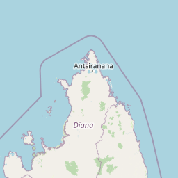
Map view of Nosy Tanikely National Park

Use this park location map to pinpoint Nosy Tanikely National Park in Madagascar, understand its exact geographic position, and read its mapped placement within the surrounding landscape more clearly.

Pigeon | © OpenStreetMap contributors
Park atlas

Browse surrounding protected areas and compare the diverse landscapes near Nosy Tanikely National Park.

Continue Exploring: National Parks and Protected Areas Near Nosy Tanikely National Park

Browse other national parks and protected areas located in the region surrounding Nosy Tanikely National Park, including diverse island ecosystems and marine conservation zones. This geographic context allows for direct comparison of park features, landscapes, and conservation efforts across a broader map of Madagascar's coastal and island protected areas, expanding your atlas exploration.
National parkMadagascar
About 13 km away#1 closest

Northeast

Lokobe National Park: Madagascar's Protected Natural Landscape and Geographic Context

Explore mapped boundaries and regional park geography.

Lokobe National Park is a protected national park situated within Madagascar, an island country recognized globally for its exceptional biodiversity and unique ecosystems. This page offers a detailed, atlas-oriented perspective on Lokobe National Park, focusing on its designation as a protected area, its specific geographic location, and the natural landscape features that define its territory. Users can explore the park's mapped boundaries and understand its contribution to Madagascar's remarkable natural heritage.

Area
15.23 km²
Established
1927
IUCN
II
Climate
Tropical
Wildlife reserveDiana
About 59 km away#2 closest

South

Manongarivo Special Reserve: Protected Wildlife and River Landscapes in Northern Madagascar

Examining the humid forest terrain and geographic boundaries of the Diana region

Located in the Diana region, Manongarivo Special Reserve serves as a critical protected area within the northern humid rainforest system of Madagascar. The territory is defined by steep forested hills, narrow river valleys, and diverse ecological niches. By analyzing its specific topographic markers and river systems, this entry details the natural landscape and protected status of this significant biodiversity reserve.

Area
327.35 km²
Established
1956
IUCN
IV
Climate
Tropical
National parkMadagascar
About 82 km away#3 closest

Southwest

Sahamalaza National Park: A Key National Park and Ramsar Wetland in Madagascar

Explore Madagascar's unique protected landscape and biodiversity hotspot

Sahamalaza National Park is a significant protected area in Madagascar, designated as both a National Park and an internationally important Ramsar Wetland. It protects vital transitional forest ecosystems and extensive coastal wetland habitats, offering a crucial refuge for critically endangered lemur species and migratory birds. The park's unique geography and ecological role provide rich context for understanding Madagascar's celebrated endemic biodiversity and conservation efforts through mapped landscape exploration.

Area
260.35 km²
Established
2007
IUCN
II
Climate
Tropical
Nature reserveDiana
About 85 km away#4 closest

Southeast

Réserve naturelle intégrale de Tsaratanana: Highland Massif and Protected Mountain Terrain

High-altitude geography in the Diana region of northern Madagascar

Spanning tens of thousands of hectares, the Réserve naturelle intégrale de Tsaratanana protects the highest mountain terrain in Madagascar. The landscape is defined by the crystalline Vohibory massif, creating a complex topography of deep valleys and dramatic elevation gradients that support endemic primate habitats and montane forest ecosystems.

Area
486.22 km²
Established
1927
IUCN
Ia
Nature reserveDiana Region
About 98 km away#5 closest

Northeast

Ankarana Special Reserve: A Detailed Geographic Atlas of the Diana Region's Limestone Plateau

Mapping the karst landscape, subterranean rivers, and cliff formations.

Examine the rugged topography of Ankarana Special Reserve, featuring a 25-kilometre-long cliff known as the Wall of Ankarana and 100 kilometres of mapped cave passages. This protected area offers deep insight into Madagascar's geological history and rare endemic lemur habitats within its dense, jagged tsingy ridges.

Area
182 km²
Established
1956
IUCN
IV
Relief
Upland
National parkMadagascar
About 140 km away#6 closest

Northeast

Montagne d'Ambre National Park: Mapped Volcanic Massif and Rainforest Boundaries in Madagascar

Protected montane landscape in the Diana Region of northern Madagascar

Centered around the prominent Mount Ambohitra, this national park showcases a distinct volcanic basaltic massif that creates a dramatic contrast with the nearby semi-desert terrain. Explore the geographic footprint of this biodiversity hotspot, featuring dense montane rainforests, numerous crater lakes, and cascading mountain waterfalls within the northern territory of Madagascar.

National parkDiana Region
About 140 km away#7 closest

Northeast

Montagne d'Ambre National Park: Volcanic Landscapes and Rainforest Geography in Diana Region

Isolated montane ecosystems and volcanic mountain terrain

Montagne d'Ambre National Park forms a distinct volcanic massif in northern Madagascar, sheltering an isolated montane rainforest within the drier Diana Region. The protected area features a network of crater lakes and waterfalls, providing a crucial water catchment for the regional capital. Its unique terrain and dense humid forests act as a natural island for endemic species, creating a sharp contrast with the surrounding semi-arid landscape.

Area
182 km²
Established
1958
IUCN
II
Relief
Mountain
Wildlife reserveDiana
About 142 km away#8 closest

Northeast

Réserve spéciale d'Analamerana: Mapped Geography and Protected Karst Ecosystems

Northern Madagascar wilderness and dry forest topography

Navigate the rugged limestone corridors and canyon networks of Réserve spéciale d'Analamerana. This protected area showcases a distinctive dry forest landscape shaped by seasonal tropical climates and serves as a critical habitat for rare endemic species within the Diana region.

Area
347 km²
Established
1956
IUCN
IV
Relief
Upland

Common questions about visiting, size, designation, and location context for Nosy Tanikely National Park

Nosy Tanikely National Park FAQs for park facts, access, geography, and protected area context

Find quick answers about Nosy Tanikely National Park, including protected-area facts, park geography, trail and visitor context, and how the park fits into its surrounding country and regional landscape.
MoriAtlas Explorer

Continue Your Protected Areas Search Across the Global Atlas

Deepen your exploration by continuing the structured search for national parks and protected areas worldwide. Utilize the comprehensive filtering capabilities to compare different conservation landscapes and refine your understanding of global park geography. Discover more about the distribution and characteristics of protected natural areas.

Global natural geography