Mori Atlas logo
National parkNosy Hara National Park

Understand the geographic boundaries and natural landscape context of this national park.

Nosy Hara National Park: Mapped Protected Landscape and Regional Geography

Nosy Hara National Park stands as a distinct protected area within the Diana Region of Madagascar. This page details the park's geographic scope, focusing on its mapped boundaries and the regional landscape context crucial for atlas exploration. Users can delve into the protected land's identity and its contribution to the area's natural geography, understanding its presence as a national park within a structured discovery framework.

limestone islandsendemic specieschameleon habitatmarine protected areaMadagascar islandskarst landscape

Nosy Hara National Park

National park

Park overview

Structured park overview, official facts, and landscape profile for Nosy Hara National Park

Nosy Hara National Park park facts, protected area profile, and essential visitor context
Review the core facts for Nosy Hara National Park, including designation, size, terrain, visitor scale, habitats, and operating context in one park-focused overview.

About Nosy Hara National Park

Nosy Hara National Park protects a distinctive limestone islet off the remote northwest coast of Madagascar. The island's karst geology has created a landscape of weathered rock formations, crevices, and small valleys that support dense vegetation despite the island's tiny footprint. This terrain provides the critical habitat that allows Brookesia micra and other endemic species to persist in this isolated island environment. The surrounding marine waters, included in the protected area since 2007, add another dimension to the park's ecological significance, protecting coral reef communities and marine life that depend on the island's coastal ecosystems. Scientific interest in Nosy Hara extends beyond the famous chameleon to encompass broader questions about island biogeography, miniaturization in reptiles, and the evolution of endemic species in isolated island systems. The park represents a significant example of how even the smallest protected areas can harbor globally important biodiversity.

Quick facts and research context for Nosy Hara National Park

Nosy Hara is located approximately 12°14′28″S 49°00′47″E in the Diana Region of northern Madagascar. The island is uninhabited and features a limestone karst foundation reaching 104 meters at its highest point. The park gained particular scientific prominence following the discovery and description of Brookesia micra in 2012, which remains the smallest known chameleon species globally. The protected area was established as part of Madagascar's marine conservation network in 2007.

Park context

Deeper park guide and search-rich context for Nosy Hara National Park

Nosy Hara National Park history, landscape, wildlife, and travel context
Explore Nosy Hara National Park through its history, landscape character, ecosystems, wildlife, conservation priorities, cultural context, and seasonal travel timing in a structured park guide built for atlas discovery and search intent.

Why Nosy Hara National Park stands out

Nosy Hara National Park is best known for housing Brookesia micra, the world's smallest known chameleon. This diminutive reptile, measuring just 29 millimeters in length, was only formally described by scientists in 2012 and represents one of the most remarkable discoveries in recent herpetology. The park's fame stems from this extraordinary species and the broader significance of such a tiny vertebrate occupying such a confined island habitat. The limestone islet also stands out for the concentrated biodiversity found within its limited area, with multiple endemic species adapted to its unique karst ecosystem.

Nosy Hara National Park history and protected-area timeline

Nosy Hara was formally designated as part of Madagascar's national park system and incorporated into the country's network of protected areas. The 2007 expansion to include the surrounding marine waters marked a significant development in the park's conservation framework, transforming it from a purely terrestrial protected area to a coastal marine park. The scientific discovery and formal description of Brookesia micra in 2012 brought international attention to the park and underscored its global conservation significance. This discovery represented a collaboration between researchers studying Madagascar's reptile fauna and highlighted how much remains unknown about the island nation's biodiversity even in relatively well-studied protected areas.

Nosy Hara National Park landscape and geographic character

The park occupies a limestone islet characterized by karst topography. The terrain features weathered limestone outcrops, rocky ridges, and irregular surfaces formed through millions of years of erosion. This geology creates numerous microhabitats within a very small area, with crevices, ledges, and shaded recesses providing shelter for the island's specialized fauna. The vegetation grows directly from the limestone substrate, forming dense ground cover and low canopy vegetation adapted to the thin soils and exposed conditions. The island rises to 104 meters at its highest point, offering limited but distinctive elevation changes across its brief expanse. The surrounding marine environment includes coastal waters and reef areas that complete the park's natural setting.

Nosy Hara National Park ecosystems, habitats, and plant life

Nosy Hara's nature is defined by its island isolation and limestone substrate, which together create a unique ecological setting. The island supports a forest ecosystem adapted to the karst environment, with vegetation that thrives on the porous limestone and tolerates the seasonal variations in moisture. The microclimate within the island's dense vegetation provides the humidity and shelter that Brookesia micra and other species require. The surrounding marine environment adds habitat diversity, with coral communities and fish species inhabiting the waters around the island. This combination of terrestrial and marine ecosystems within a single protected area increases the overall ecological value of the park.

Nosy Hara National Park wildlife and species highlights

The wildlife of Nosy Hara National Park centers on its extraordinary reptile fauna, most notably Brookesia micra, the smallest known chameleon species. This tiny reptile lives among the leaf litter and low vegetation of the island's limestone forest, where its diminutive size and cryptic coloration provide effective camouflage. Beyond the famous chameleon, the island supports additional endemic species adapted to this isolated environment. The surrounding marine waters contain coral reef communities with associated fish and invertebrate species. The park's global significance derives not from the number of species present but from the extraordinary adaptations and endemism found within this very limited area.

Nosy Hara National Park conservation status and protection priorities

Nosy Hara National Park holds significant conservation importance disproportionate to its tiny size. The discovery of the world's smallest chameleon elevated the park to global scientific and conservation attention. The inclusion of surrounding marine waters in 2007 expanded the protection framework to address coastal and marine biodiversity alongside terrestrial values. The park exemplifies how small island reserves can harbor species found nowhere else on Earth, making them critically important for biodiversity preservation. The endemic species confined to Nosy Hara face inherent vulnerability due to their restricted range, making the protected area status essential for their long-term survival.

Nosy Hara National Park cultural meaning and human context

Nosy Hara is an uninhabited island with no permanent human population. The island does not have a history of significant human settlement or traditional land use that would inform a cultural context section. The park's significance is primarily ecological and scientific rather than cultural or historical in the traditional sense.

Top sights and standout views in Nosy Hara National Park

Nosy Hara stands as a remarkable example of island biodiversity compressed into a tiny limestone islet. The discovery of Brookesia micra, the world's smallest chameleon, represents one of herpetology's most significant recent findings and brought scientific fame to this small protected area. The park demonstrates how isolated island ecosystems can evolve unique species found nowhere else, making it important for understanding evolutionary processes and conservation priorities. The combination of terrestrial and marine protection within a single park adds further value to its conservation framework.

Best time to visit Nosy Hara National Park

Visiting Nosy Hara National Park is typically best during Madagascar's dry season from April through October, when conditions are more favorable for travel to the island. The dry period offers clearer weather and easier access to the remote northwest coast. However, the island's small size and the specific research focus of most visits mean that access may be limited regardless of season. Visitors interested in observing wildlife should be aware that the forest-dwelling species are more active during humid conditions, and the dense vegetation provides shade throughout the year.
Park location guide

Geography guide, regional context, and park location map for Nosy Hara National Park

Nosy Hara National Park park geography, regions, and map view in Madagascar
Understand where Nosy Hara National Park sits in Madagascar through a broader geographic reading of the surrounding landscape, nearby location context, and its mapped position within the national park landscape.

How Nosy Hara National Park fits into Madagascar

Madagascar is an island nation in the Indian Ocean, positioned off the southeastern coast of Africa. As the world's fourth-largest island and second-largest island country, it stands out for its exceptional biodiversity, over 90% of its wildlife is endemic, making it one of 17 megadiverse countries. The population is approximately 32 million, with Antananarivo as both the capital and largest city.

Wider geography shaping Nosy Hara National Park in Madagascar

Madagascar lies in the Indian Ocean off the southeastern coast of Africa, separated from the mainland by the Mozambique Channel. The island is situated approximately 400 km from the African continent. As the world's fourth-largest island, it also includes numerous smaller peripheral islands.

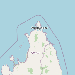
Map view of Nosy Hara National Park

Use this park location map to pinpoint Nosy Hara National Park in Madagascar, understand its exact geographic position, and read its mapped placement within the surrounding landscape more clearly.

Pigeon | © OpenStreetMap contributors

Location context for Nosy Hara National Park

Diana Region
Park atlas

Browse a geographic atlas of national parks, marine protected areas, and unique karst landscapes across Madagascar's northwest coast

Discover More Protected Areas Near Nosy Hara National Park and Its Karst Island Ecosystems
Continue your exploration of Madagascar's protected areas by discovering other national parks and marine reserves geographically connected to Nosy Hara National Park. Compare diverse protected landscapes, including additional limestone islands and coastal ecosystems, to understand broader conservation patterns in the Diana Region.
National parkMadagascar

Lokobe National Park: Madagascar's Protected Natural Landscape and Geographic Context

Explore mapped boundaries and regional park geography.

Lokobe National Park is a protected national park situated within Madagascar, an island country recognized globally for its exceptional biodiversity and unique ecosystems. This page offers a detailed, atlas-oriented perspective on Lokobe National Park, focusing on its designation as a protected area, its specific geographic location, and the natural landscape features that define its territory. Users can explore the park's mapped boundaries and understand its contribution to Madagascar's remarkable natural heritage.

Area
15.23 km²
Established
1927
IUCN
II
Climate
Tropical
Watercolor painting of a mountainous landscape with green vegetation, a body of water, and distant peaks under a light sky
National parkMadagascar

Marojejy National Park: A Protected National Park within Madagascar's Unique Geography

Mapped landscape context and regional protected area significance.

Marojejy National Park is a distinct protected area offering rich insights into Madagascar's natural geography. As a national park, its mapped boundaries define a significant landscape that contributes to the island nation's reputation as a biodiversity hotspot. This entry provides essential context for understanding Marojejy National Park's role within the country's protected lands and its value for structured geographic atlas exploration.

Area
555 km²
Established
1998
IUCN
II
Relief
Mountain
Watercolor illustration of a mountainous landscape with a lake and grassy fields.
National parkAnjouan

Mount Ntringui National Park: Protected Volcanic Landscape and Highland Geography on Anjouan

Explore its dramatic peaks, crater lake, and remnant montane forests.

Mount Ntringui National Park is a significant protected area situated in the rugged volcanic highlands of Anjouan. This national park preserves the island's highest peaks, Mount Ntringui and Mount Trindrini, alongside the unique Dzialandzé crater lake and the crucial Moya Forest. It stands as a vital refuge for endemic species and represents the last substantial tract of montane forest on Anjouan, offering deep insights into the region's unique ecology and mapped natural terrain.

Area
79.14 km²
Established
2010
IUCN
II
Relief
Mountain
National parkBoeny Region

Ankarafantsika National Park: Protected Area Atlas and Regional Geography Discovery

Explore mapped boundaries and natural landscape context.

Ankarafantsika National Park serves as a key protected area for understanding the geography of Madagascar's Boeny Region. This canonical page offers a detailed atlas-style view, highlighting the park's mapped boundaries and its role as a distinct natural landscape. Engage with structured geographic data to comprehend the park's protected status and its contribution to the regional terrain, facilitating a deeper appreciation of protected lands.

Area
1,365.13 km²
Established
2002
IUCN
II
Relief
Lowland
National parkAnjouan

Shisiwani National Park: Anjouan's Protected Marine and Island Landscape Atlas

Coastal and terrestrial protected area mapping in Comoros.

Delve into the protected landscape of Shisiwani National Park, a critical national park situated on Anjouan's Sima Peninsula in Comoros. This atlas entry details the park's combined marine and terrestrial boundaries, highlighting its vital coral reefs, mangrove forests, and unique island geography. Understand the park's role in conservation through its mapped extent and diverse natural environments, offering a clear geographic context for protected area exploration.

Area
64.97 km²
Established
2016
IUCN
II
Climate
Tropical
National parkComoros

Mohéli National Park: Comoros National Park and Protected Landscape Exploration

Mapped geography and protected area identity.

Mohéli National Park is a dedicated national park within the Comoros, providing a specific focus for exploring protected lands and their geographic distribution. This entry details the park's mapped boundaries and its significance as a conservation landscape. Understanding Mohéli National Park offers valuable insight into the regional geography of the Comoros archipelago and its unique natural context.

Area
643.62 km²
Established
2010
Relief
Mixed relief
Climate
Tropical
National parkBoeny

Baie de Baly National Park: Mapped Boundaries and Protected Landscape Context

Explore the geography and natural terrain of this national park.

Baie de Baly National Park presents a critical focal point for understanding protected areas within the Boeny region. As a national park, it showcases specific mapped boundaries that contribute to the broader geographic understanding of Madagascar's conservation landscapes. This detailed view allows for an atlas-driven exploration of the park's natural terrain and its significance as a distinct protected landmass within its regional context.

Area
571.42 km²
Established
1997
IUCN
II
Climate
Tropical
National parkMadagascar

Zahamena National Park: Madagascar National Park Exploration and Geographic Context

Mapping the protected boundaries and landscape of Zahamena National Park.

Delve into Zahamena National Park, a vital protected territory situated in Madagascar. This national park offers a unique perspective on the island's natural geography and its status as a significant protected landscape. Understand its position within Madagascar's broader context, focusing on the mapped aspects of its protected area identity and its contribution to the country's renowned biodiversity hotspot status.

Area
423 km²
Established
1997
IUCN
II
Relief
Mountain

Common questions about visiting, size, designation, and location context for Nosy Hara National Park

Nosy Hara National Park FAQs for park facts, access, geography, and protected area context
Find quick answers about Nosy Hara National Park, including protected-area facts, park geography, trail and visitor context, and how the park fits into its surrounding country and regional landscape.
MoriAtlas Explorer

Continue Your Protected Areas Search Across the Global Atlas

Deepen your exploration by continuing the structured search for national parks and protected areas worldwide. Utilize the comprehensive filtering capabilities to compare different conservation landscapes and refine your understanding of global park geography. Discover more about the distribution and characteristics of protected natural areas.

Global natural geography
Nosy Hara National Park: Protected Area Map and Geography in Diana Region