Mori Atlas logo
National parkAnkarafantsika National Park

Discover the mapped boundaries and regional geography of this national park.

Ankarafantsika National Park: Protected Landscape and Geographic Context in Boeny Region

(Zones Humides Ankarafantsika)

Ankarafantsika National Park represents a significant protected landscape within Madagascar's Boeny Region. This page provides an atlas-driven exploration of its geographic identity, focusing on its mapped boundaries and its place within the regional terrain. Users can delve into the structured details of this national park to understand its protected area context and landscape characteristics for comprehensive geographic discovery.

dry forestnational parkMadagascarendemic specieslemursRamsar site

Ankarafantsika National Park

National park

Park overview

Structured park overview, official facts, and landscape profile for Ankarafantsika National Park

Ankarafantsika National Park park facts, protected area profile, and essential visitor context
Review the core facts for Ankarafantsika National Park, including designation, size, terrain, visitor scale, habitats, and operating context in one park-focused overview.

About Ankarafantsika National Park

Ankarafantsika National Park represents one of the last significant remnants of Madagascar's vanishing dry deciduous forests. The park's landscape is characterized by dense stands of thick tropical forest interspersed with more open savannah zones, scrubland, and patches of sandy eroded rock. The forest canopy is dominated by numerous tree species, many of which are endemic to Madagascar including the flowering bush mpanjakabenitany, the medicinally significant katrafay, and the large-flowered sakoanala. Several lakes punctuate the landscape, with Lake Ravelobe being the most prominent and serving as a vital water source for the park's wildlife. The area is crisscrossed by tracks and paths that allow visitors to explore the different habitats, and basic lodging facilities are available for those wishing to extend their stay. The surrounding landscape includes areas where the indigenous Sakalava people practice traditional agriculture, creating a mosaic of protected and community-managed land.

Quick facts and research context for Ankarafantsika National Park

Ankarafantsika National Park covers 1,365 square kilometers in northwestern Madagascar's Boeny Region. The protected area was established as a nature reserve in 1927 and became a national park in 2002 when two separate forest blocks flanking Route 4 were consolidated. The ecosystem consists primarily of dry tropical forest with interspersed savannah, scrubland, and rocky outcrops. The park contains several lakes including Lake Ravelobe, which serves as a focal point for wildlife viewing. The Sakalava people are the predominant ethnic community living within and around the park boundaries. The area was designated as a Ramsar Wetland site in February 2017.

Park context

Deeper park guide and search-rich context for Ankarafantsika National Park

Ankarafantsika National Park history, landscape, wildlife, and travel context
Explore Ankarafantsika National Park through its history, landscape character, ecosystems, wildlife, conservation priorities, cultural context, and seasonal travel timing in a structured park guide built for atlas discovery and search intent.

Why Ankarafantsika National Park stands out

Ankarafantsika is best known for its exceptional concentration of endemic wildlife, particularly its populations of lemurs and the critically important dry forest habitat. The park supports eight species of lemurs, including mouse lemurs among the world's smallest primates, and provides crucial protection for the greater big-footed mouse, a rodent species known only from this area and its immediate surroundings. The bird fauna is equally remarkable, with 129 species recorded including the endangered Madagascar fish eagle and Madagascar heron, both regularly observed around Lake Ravelobe. The park also protects rare reptiles including the Madagascan big-headed turtle and several endemic chameleon species.

Ankarafantsika National Park history and protected-area timeline

Ankarafantsika's protection history began in 1927 when the area was established as a nature reserve, reflecting early recognition of the region's ecological significance. For many decades, the protected area existed as two separate forest blocks positioned on either side of the national Route 4 road. In 2002, these two units were formally consolidated to create a single national park, expanding the scope of protection and simplifying management. The park is governed by Madagascar National Parks, the country's primary protected area management authority. In 2017, the park gained additional recognition through Ramsar Convention designation as a Wetland of International Importance, specifically acknowledging the significance of the lakes and associated wetland habitats within the park boundaries.

Ankarafantsika National Park landscape and geographic character

The physical landscape of Ankarafantsika National Park features a diverse topography characterized by dry tropical forest covering the more elevated terrain, transitioning into savannah grasslands and scrubland in lower-lying areas. The park sits within a region defined by two major river systems: the Betsiboka River marks the western boundary while the Mahajamba River forms the eastern edge. Several lakes and seasonal water bodies are scattered throughout the park, with Lake Ravelobe being the most significant. The forest areas consist of patches of thick, intact canopy interspersed with more degraded or less dense vegetation. Rocky sandstone outcrops emerge in places, while some areas have been historically impacted by agriculture and remain as cultivated land or disturbed scrub. The overall impression is of a semi-natural landscape where intact forest and more open habitats form a complex mosaic.

Ankarafantsika National Park ecosystems, habitats, and plant life

The ecological character of Ankarafantsika is defined by Madagascar's dry deciduous forest ecosystem, one of the island's most threatened habitat types. Over 800 plant species have been recorded within the park, the majority of which are endemic to Madagascar, reflecting the island's extraordinary level of biodiversity and endemism. The forest structure supports a complex多层 of ecological niches, from the canopy to the forest floor. The presence of multiple lake systems adds aquatic and wetland habitats to the terrestrial forest environments, creating ecological diversity within the protected area. The ecosystem supports significant populations of native wildlife despite the surrounding landscape being heavily modified by human activity. The Ramsar designation acknowledges the wetland components as internationally significant habitats, particularly for waterbirds and aquatic reptiles.

Ankarafantsika National Park wildlife and species highlights

Ankarafantsika supports an exceptional array of wildlife, with particular significance attached to its lemur populations. Eight species of lemurs inhabit the forest, including species of mouse lemurs representing the world's smallest primates. The greater big-footed mouse, a recently described rodent species, is known only from Ankarafantsika and surrounding areas, making the park critical for the survival of this endemic species. The reptile fauna includes ten amphibian species and 44 reptile species, among them the rare Madagascan big-headed turtle, rhinoceros chameleon, dwarf chameleon, and two ground-dwelling boa species. Birdlife is exceptionally diverse with 129 species recorded, more than half of which are endemic to Madagascar. Notable species include Van Dam's vanga, rufous vanga, banded kestrel, and the endangered Madagascar fish eagle, which can regularly be observed at Lake Ravelobe along with the Madagascar heron.

Ankarafantsika National Park conservation status and protection priorities

Ankarafantsika National Park plays a crucial role in conserving Madagascar's biodiversity, protecting what remains of the island's dry forest ecosystem which has been heavily cleared for agriculture and charcoal production. The park's Ramsar designation emphasizes the international importance of its wetland habitats, particularly for migratory waterbirds and endemic aquatic species. The protection of the greater big-footed mouse within the park is especially significant as this species is found nowhere else in the world. Similarly, the concentration of endemic bird species, including several considered threatened, makes the area a priority for conservation efforts. The park represents a living laboratory for studying Madagascar's unique evolutionary heritage and provides ecosystem services including watershed protection and carbon storage.

Ankarafantsika National Park cultural meaning and human context

The Sakalava people are the predominant ethnic group residing within and around Ankarafantsika National Park, maintaining traditional patterns of land use and agricultural practice in the region. Their presence within the park boundary includes areas of cultivated land where they practice subsistence farming, creating a cultural landscape that intersects with the protected ecosystem. The Sakalava are historically one of Madagascar's major ethnic groups, with their traditional territory spanning much of the western coastal region. Understanding the relationship between the local communities and the protected area is important for effective park management and long-term conservation success.

Top sights and standout views in Ankarafantsika National Park

Ankarafantsika offers visitors the opportunity to encounter Madagascar's endemic wildlife in one of the island's most accessible forest reserves. The chance to observe multiple lemur species, including the tiny mouse lemurs, provides a unique wildlife experience. Lake Ravelobe serves as a reliable location for spotting the Madagascar fish eagle and Madagascar heron, while the forest trails reveal chameleons, endemic birds, and the rare greater big-footed mouse. The park's size and habitat diversity allow for multi-day explorations with guided walks through both dense forest and more open savannah zones. The combination of terrestrial and wetland habitats within a single protected area creates a multifaceted destination for nature enthusiasts.

Best time to visit Ankarafantsika National Park

The optimal period for visiting Ankarafantsika National Park falls during the dry season from April through October, when weather conditions are most comfortable for outdoor exploration and wildlife viewing is facilitated by reduced vegetation density. During this season, animals tend to congreg more readily around remaining water sources, making Lake Ravelobe particularly productive for observing waterbirds and aquatic species. The wet season from November through March brings higher temperatures and heavier rainfall, which can make trail conditions challenging and wildlife more difficult to locate. However, the wet season transforms the landscape with lush vegetation and may offer different wildlife viewing opportunities. The park can be visited year-round, but the dry season months generally provide the most reliable conditions for wildlife observation and hiking.
Park location guide

Geography guide, regional context, and park location map for Ankarafantsika National Park

Ankarafantsika National Park park geography, regions, and map view in Madagascar
Understand where Ankarafantsika National Park sits in Madagascar through a broader geographic reading of the surrounding landscape, nearby location context, and its mapped position within the national park landscape.

How Ankarafantsika National Park fits into Madagascar

Madagascar is an island nation in the Indian Ocean, positioned off the southeastern coast of Africa. As the world's fourth-largest island and second-largest island country, it stands out for its exceptional biodiversity, over 90% of its wildlife is endemic, making it one of 17 megadiverse countries. The population is approximately 32 million, with Antananarivo as both the capital and largest city.

Wider geography shaping Ankarafantsika National Park in Madagascar

Madagascar lies in the Indian Ocean off the southeastern coast of Africa, separated from the mainland by the Mozambique Channel. The island is situated approximately 400 km from the African continent. As the world's fourth-largest island, it also includes numerous smaller peripheral islands.

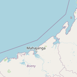
Map view of Ankarafantsika National Park

Use this park location map to pinpoint Ankarafantsika National Park in Madagascar, understand its exact geographic position, and read its mapped placement within the surrounding landscape more clearly.

Pigeon | © OpenStreetMap contributors

Location context for Ankarafantsika National Park

Boeny Region
Park atlas

Browse surrounding conservation landscapes and compare protected areas in Madagascar's Boeny Region.

Explore More National Parks and Protected Areas Near Ankarafantsika National Park in Northwestern Madagascar
Continue exploring Madagascar's national parks and protected areas beyond Ankarafantsika, tracing dry forest ecosystems and adjacent wetland conservation landscapes across its northwestern and central regions. Compare varied protected areas, understand regional ecological connections, and map the unique spread of Madagascar's endemic wildlife within a broader geographic context.
National parkBoeny

Baie de Baly National Park: Mapped Boundaries and Protected Landscape Context

Explore the geography and natural terrain of this national park.

Baie de Baly National Park presents a critical focal point for understanding protected areas within the Boeny region. As a national park, it showcases specific mapped boundaries that contribute to the broader geographic understanding of Madagascar's conservation landscapes. This detailed view allows for an atlas-driven exploration of the park's natural terrain and its significance as a distinct protected landmass within its regional context.

Area
571.42 km²
Established
1997
IUCN
II
Climate
Tropical
National parkMadagascar

Zahamena National Park: Madagascar National Park Exploration and Geographic Context

Mapping the protected boundaries and landscape of Zahamena National Park.

Delve into Zahamena National Park, a vital protected territory situated in Madagascar. This national park offers a unique perspective on the island's natural geography and its status as a significant protected landscape. Understand its position within Madagascar's broader context, focusing on the mapped aspects of its protected area identity and its contribution to the country's renowned biodiversity hotspot status.

Area
423 km²
Established
1997
IUCN
II
Relief
Mountain
National parkAlaotra-Mangoro

Andasibe-Mantadia National Park: National Park and Protected Landscape Identity

Explore its mapped boundaries and geographic context.

Andasibe-Mantadia National Park is a distinct protected territory within the Alaotra-Mangoro region, serving as a crucial focal point for understanding Madagascar's regional geography and protected land distribution. This detail page provides essential atlas-style information on the park's mapped area and its natural landscape characteristics. Engage with structured data that highlights the park's protected status and its position within the broader geographic framework of eastern Madagascar, supporting focused discovery for researchers and explorers.

Area
155 km²
Established
1989
IUCN
II
Visitors
26.1K annual
Watercolor illustration of a landscape featuring mountains, a lake, trees, and pink flowers in the foreground
National parkAlaotra-Mangoro

Analamazaotra National Park: Protected Rainforest Ecosystem and Mapped Landscape in Alaotra-Mangoro

Explore Madagascar's Eastern Highlands protected area geography.

Analamazaotra National Park, situated in Madagascar's Alaotra-Mangoro region, represents a critical segment of the island's protected eastern rainforests. This national park is mapped as a vital conservation area, offering insights into its unique ecosystems and natural terrain. Understanding Analamazaotra National Park's geographic placement and protected boundaries provides essential context for regional landscape exploration and atlas-based geographic discovery within Madagascar.

Area
26.53 km²
Established
2015
IUCN
II
Relief
Highland
National parkMelaky

Tsingy de Bemaraha National Park: A Protected Landscape within Melaky, Madagascar

Explore mapped boundaries and regional geography for atlas discovery.

Tsingy de Bemaraha National Park is a designated national park offering profound opportunities for geographic discovery. As a key protected area in the Melaky region, its mapped boundaries and natural landscape characteristics are vital for understanding Madagascar's conservation geography. This resource facilitates detailed atlas exploration, providing structured insights into the park's terrain and its position within the broader regional context, enabling a focused study of its protected land identity.

Area
723.4 km²
Established
1997
IUCN
II
Visitors
10.1K annual
National parkMadagascar

Lokobe National Park: Madagascar's Protected Natural Landscape and Geographic Context

Explore mapped boundaries and regional park geography.

Lokobe National Park is a protected national park situated within Madagascar, an island country recognized globally for its exceptional biodiversity and unique ecosystems. This page offers a detailed, atlas-oriented perspective on Lokobe National Park, focusing on its designation as a protected area, its specific geographic location, and the natural landscape features that define its territory. Users can explore the park's mapped boundaries and understand its contribution to Madagascar's remarkable natural heritage.

Area
15.23 km²
Established
1927
IUCN
II
Climate
Tropical
Watercolor painting of a mountainous landscape with green vegetation, a body of water, and distant peaks under a light sky
National parkMadagascar

Marojejy National Park: A Protected National Park within Madagascar's Unique Geography

Mapped landscape context and regional protected area significance.

Marojejy National Park is a distinct protected area offering rich insights into Madagascar's natural geography. As a national park, its mapped boundaries define a significant landscape that contributes to the island nation's reputation as a biodiversity hotspot. This entry provides essential context for understanding Marojejy National Park's role within the country's protected lands and its value for structured geographic atlas exploration.

Area
555 km²
Established
1998
IUCN
II
Relief
Mountain
National parkMadagascar

Marolambo National Park: Madagascar's National Park and Protected Landscape

Explore mapped boundaries and regional geography.

Marolambo National Park stands as a protected national park within Madagascar's globally recognized biodiversity hotspot. This entry provides focused insight into its protected landscape, its specific geographic context within the island nation, and its role in the conservation of unique natural terrain. Understanding Marolambo National Park through its mapped boundaries and regional geography contributes to a broader atlas exploration of Madagascar's endemic ecosystems.

Area
950.63 km²
Climate
Tropical
Access
Remote access
Scope
Terrestrial

Common questions about visiting, size, designation, and location context for Ankarafantsika National Park

Ankarafantsika National Park FAQs for park facts, access, geography, and protected area context
Find quick answers about Ankarafantsika National Park, including protected-area facts, park geography, trail and visitor context, and how the park fits into its surrounding country and regional landscape.
MoriAtlas Explorer

Continue Your Protected Areas Search Across the Global Atlas

Deepen your exploration by continuing the structured search for national parks and protected areas worldwide. Utilize the comprehensive filtering capabilities to compare different conservation landscapes and refine your understanding of global park geography. Discover more about the distribution and characteristics of protected natural areas.

Global natural geography