

Mori Atlas logo
National parkMarolambo National Park

Discover the mapped landscape and protected boundaries of Marolambo National Park.

Marolambo National Park: A Protected National Park in Madagascar's Unique Geography

Marolambo National Park, situated within the distinct island geography of Madagascar, represents a significant protected area contributing to the nation's status as a biodiversity hotspot. This page offers a gateway to understanding the park's specific geographic identity, its mapped protected landscape, and its context within the broader natural terrain of the island. Explore the core attributes of this national park for a structured understanding of its protected area significance.

Rainforest Protected AreaWaterfallRemote WildernessEastern MadagascarNational ParkEndemic Biodiversity

Marolambo National Park

National park

Park overview

Structured park overview, official facts, and landscape profile for Marolambo National Park

Marolambo National Park park facts, protected area profile, and essential visitor context
Review the core facts for Marolambo National Park, including designation, size, terrain, visitor scale, habitats, and operating context in one park-focused overview.

About Marolambo National Park

Marolambo National Park occupies a significant tract of eastern Madagascar's interior, protecting portions of the island's eastern rainforest biome across a complex mosaic of administrative regions. The park's location between multiple regional centers reflects its position along a transitional zone between different highland and lowland environments. While the exact date of the park's formal establishment is not detailed in available sources, it operates under the governance of Madagascar National Parks Association, the country's primary protected area management body. The park's inaccessibility defines much of its character, with the only practical means of entry being extended hiking expeditions that can last several days from the nearest population centers. This remoteness has preserved relatively intact forest ecosystems despite the broader pressures facing Madagascar's natural habitats. The park's territory encompasses varied topography associated with the island's eastern mountain chain and adjacent lowland areas, creating diverse habitat conditions within a single protected unit.

Quick facts and research context for Marolambo National Park

Marolambo National Park is located in eastern Madagascar at coordinates approximately 20°00′S 47°40′E. The protected area spans roughly 95,063 hectares of primarily forested terrain across six administrative regions. The park contains Madagascar's highest waterfall, Andrevaronina Falls on the Sakaleona River, which drops approximately 350 meters. Visitor numbers were recorded as zero in 2006, reflecting the park's extreme remoteness and limited accessibility. The park headquarters are situated in Fandriana, and access typically requires multi-day hiking expeditions.

Park context

Deeper park guide and search-rich context for Marolambo National Park

Marolambo National Park history, landscape, wildlife, and travel context
Explore Marolambo National Park through its history, landscape character, ecosystems, wildlife, conservation priorities, cultural context, and seasonal travel timing in a structured park guide built for atlas discovery and search intent.

Why Marolambo National Park stands out

Marolambo National Park is best known for containing the highest waterfall in Madagascar, the Andrevaronina Falls on the Sakaleona River, which plummets roughly 350 meters. The park is also renowned for its exceptional remoteness and the challenge it presents to visitors, requiring hikers to traverse difficult terrain for days to reach its core areas. The protected forest landscapes represent some of the less-visited eastern rainforest ecosystems in Madagascar, offering a wilderness experience far removed from more accessible parks.

Marolambo National Park history and protected-area timeline

The formal establishment of Marolambo National Park occurred as part of Madagascar's broader protected area expansion efforts coordinated through the Madagascar National Parks Association. While specific dates regarding the park's designation are limited in the source material, its creation reflects the national priority to conserve eastern rainforest corridors that harbor exceptional biodiversity. The park was integrated into the country's network of national parks managed by Madagascar National Parks Association, which maintains administrative oversight from its headquarters in Fandriana. The park's relative obscurity in international conservation circles compared to more established parks like Ranomafana or Andasibe-Mantadia likely reflects its challenging access conditions rather than any deficiency in ecological value. The absence of significant tourism infrastructure and the need for multi-day hiking expeditions to reach the park's interior have maintained its wilderness character.

Marolambo National Park landscape and geographic character

The landscape of Marolambo National Park is characterized by the rugged terrain typical of eastern Madagascar, where the island's central highlands descend toward the coastal lowlands. The park encompasses forested slopes, valleys, and ridgelines associated with the Sakaleona River basin and its tributaries. The defining physical feature is the Andrevaronina Falls, which represents Madagascar's highest waterfall with a drop of approximately 350 meters, formed where the Sakaleona River cascades over a dramatic cliff in the park's interior. The terrain varies from lower elevation areas in the eastern portions to higher ground approaching the central highlands, creating environmental gradients that support diverse ecological communities. The forest-covered landscape presents a typically dense tropical appearance with the steep terrain creating numerous microhabitats and visual drama throughout the protected area.

Marolambo National Park ecosystems, habitats, and plant life

Marolambo National Park protects substantial tracts of eastern Madagascar's rainforest ecosystems, representing an important component of the island's eastern biodiversity corridor. The protected forests occur across an elevation gradient that supports varied plant communities, from lowland rainforest in the eastern portions to transitional forest types at higher elevations. While detailed species inventories are not provided in the source material, the park's eastern Madagascar location places it within a region renowned for high levels of endemism across numerous taxonomic groups. The forest ecosystems likely include characteristic species from the island's unique flora, with the protected area serving as a reservoir for biodiversity in a region facing ongoing deforestation pressures. The park's remote character has allowed these ecosystems to persist relatively intact compared to more accessible areas.

Marolambo National Park wildlife and species highlights

While specific wildlife details are not extensively documented in available sources, Marolambo National Park's location in eastern Madagascar places it within one of the island's most biodiverse regions. The eastern rainforests are home to numerous endemic species including lemurs, birds, reptiles, and amphibians that occur nowhere else on Earth. The park's protected status provides conservation space for these species in a region where habitat loss remains a significant pressure. The forest canopy supports diverse avifauna, while the understory and ground layers harbor various endemic mammals, reptiles, and insects. The Sakaleona River and its tributaries likely contain endemic aquatic species adapted to the clear mountain waters. Visitors undertaking the challenging hikes through the park may encounter various wildlife species, though the park's remoteness means wildlife viewing opportunities remain less documented than in more accessible protected areas.

Marolambo National Park conservation status and protection priorities

Marolambo National Park contributes to Madagascar's protected area network by preserving a substantial tract of eastern rainforest that might otherwise face conversion pressures. The park's designation provides legal protection for its forest ecosystems and the biodiversity they contain, including potentially threatened species that depend on intact habitat. The challenging access conditions that limit human visitation also serve as a de facto protection mechanism, reducing pressure from tourism and development that has affected more accessible parks. Conservation of this area supports broader regional efforts to maintain connectivity between protected areas in Madagascar's eastern forest corridor, which is essential for species that require large home ranges or dispersal routes between habitat patches. The park's management by Madagascar National Parks Association connects it to the country's primary conservation governance framework.

Marolambo National Park cultural meaning and human context

The territory of Marolambo National Park spans multiple traditional administrative regions of eastern Madagascar, each with distinct local communities and cultural histories. The park is bounded by several regional centers including Marolambo, Fandriana, Ambositra, and Nosy Varika, each representing different aspects of Madagascar's highland and eastern lowland cultural landscapes. The local communities in this region maintain traditional relationships with the forest landscape, though specific indigenous or traditional land use practices within the park boundaries are not detailed in available sources. The park's name derives from the town of Marolambo, which serves as a regional reference point for this protected area.

Top sights and standout views in Marolambo National Park

The primary highlight of Marolambo National Park is undoubtedly Madagascar's highest waterfall, Andrevaronina Falls, which drops approximately 350 meters over the Sakaleona River. This dramatic natural feature alone justifies the considerable effort required to reach the park's interior through multi-day hiking expeditions. Beyond the waterfall, the park offers access to some of eastern Madagascar's more pristine and rarely visited rainforest environments, providing a wilderness experience distinctly different from more accessible protected areas. The challenge of reaching the park itself becomes part of the appeal for adventurous travelers seeking to explore Madagascar's less-touristed landscapes. The park's biodiversity value, while less documented than in more studied areas, represents another significant highlight for conservation-minded visitors.

Best time to visit Marolambo National Park

The optimal time to visit Marolambo National Park would align with Madagascar's dry season, typically running from May through October, when trail conditions are most favorable for hiking and the risk of heavy rainfall is reduced. The dry season offers more manageable conditions for the multi-day hikes required to access the park's interior, as the rainy season would transform trails into difficult, slippery passages. However, the park's remote character means that even during the optimal season, visitors should be prepared for demanding terrain and limited infrastructure. The lack of visitor facilities and the requirement for self-sufficient trekking mean that planning should account for extended expedition-style travel regardless of when visits occur.
Park location guide

Geography guide, regional context, and park location map for Marolambo National Park

Marolambo National Park park geography, regions, and map view in Madagascar
Understand where Marolambo National Park sits in Madagascar through a broader geographic reading of the surrounding landscape, nearby location context, and its mapped position within the national park landscape.

How Marolambo National Park fits into Madagascar

Madagascar is an island nation in the Indian Ocean, positioned off the southeastern coast of Africa. As the world's fourth-largest island and second-largest island country, it stands out for its exceptional biodiversity, over 90% of its wildlife is endemic, making it one of 17 megadiverse countries. The population is approximately 32 million, with Antananarivo as both the capital and largest city.

Wider geography shaping Marolambo National Park in Madagascar

Madagascar lies in the Indian Ocean off the southeastern coast of Africa, separated from the mainland by the Mozambique Channel. The island is situated approximately 400 km from the African continent. As the world's fourth-largest island, it also includes numerous smaller peripheral islands.

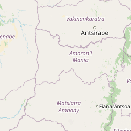
Map view of Marolambo National Park

Use this park location map to pinpoint Marolambo National Park in Madagascar, understand its exact geographic position, and read its mapped placement within the surrounding landscape more clearly.

Pigeon | © OpenStreetMap contributors

Location context for Marolambo National Park

Amoron'i ManiaAtsinanana
Park atlas

Compare nearby national parks and trace the regional geography of protected landscapes around Marolambo National Park.

Explore Other National Parks Near Marolambo National Park and Eastern Madagascar's Protected Landscapes
Browse a curated list of national parks and protected areas located in the geographical vicinity of Marolambo National Park, extending across eastern Madagascar's rugged terrain. This structured park list provides essential regional context for comparing varied protected landscapes, tracing conservation efforts, and understanding the spread of biodiversity in the island's remote wilderness.
National parkMadagascar

Ranomafana National Park: Madagascar's premier Tropical Rainforest Protected Area

Explore its unique mapped geography and landscape context.

Ranomafana National Park stands as a crucial national park within Madagascar's protected lands, safeguarding a significant expanse of tropical rainforest. This page offers a deep dive into its geographic setting, detailing the mapped boundaries and the distinctive natural terrain that supports its exceptional biodiversity. Discover the atlas value of this protected landscape for understanding regional conservation and geographic context.

Area
416 km²
Established
1991
IUCN
II
Climate
Tropical
National parkAlaotra-Mangoro

Andasibe-Mantadia National Park: National Park and Protected Landscape Identity

Explore its mapped boundaries and geographic context.

Andasibe-Mantadia National Park is a distinct protected territory within the Alaotra-Mangoro region, serving as a crucial focal point for understanding Madagascar's regional geography and protected land distribution. This detail page provides essential atlas-style information on the park's mapped area and its natural landscape characteristics. Engage with structured data that highlights the park's protected status and its position within the broader geographic framework of eastern Madagascar, supporting focused discovery for researchers and explorers.

Area
155 km²
Established
1989
IUCN
II
Visitors
26.1K annual
Watercolor illustration of a landscape featuring mountains, a lake, trees, and pink flowers in the foreground
National parkAlaotra-Mangoro

Analamazaotra National Park: Protected Rainforest Ecosystem and Mapped Landscape in Alaotra-Mangoro

Explore Madagascar's Eastern Highlands protected area geography.

Analamazaotra National Park, situated in Madagascar's Alaotra-Mangoro region, represents a critical segment of the island's protected eastern rainforests. This national park is mapped as a vital conservation area, offering insights into its unique ecosystems and natural terrain. Understanding Analamazaotra National Park's geographic placement and protected boundaries provides essential context for regional landscape exploration and atlas-based geographic discovery within Madagascar.

Area
26.53 km²
Established
2015
IUCN
II
Relief
Highland
National parkHaute Matsiatra

Andringitra National Park: A Protected Landscape within Haute Matsiatra's Geography

Explore mapped park boundaries and regional terrain.

Andringitra National Park represents a vital protected area within the Haute Matsiatra region, contributing significantly to the mapped landscape of central Madagascar. Its designation as a national park underscores its importance for conservation and geographic study. Users exploring this destination can gain a detailed understanding of its specific protected boundaries, the surrounding natural terrain, and its overall contribution to the regional geography, making it a key site for atlas-based landscape discovery.

Area
311.6 km²
Established
1999
IUCN
II
Visitors
3.4K annual
National parkMadagascar

Zahamena National Park: Madagascar National Park Exploration and Geographic Context

Mapping the protected boundaries and landscape of Zahamena National Park.

Delve into Zahamena National Park, a vital protected territory situated in Madagascar. This national park offers a unique perspective on the island's natural geography and its status as a significant protected landscape. Understand its position within Madagascar's broader context, focusing on the mapped aspects of its protected area identity and its contribution to the country's renowned biodiversity hotspot status.

Area
423 km²
Established
1997
IUCN
II
Relief
Mountain
National parkMelaky

Tsingy de Bemaraha National Park: A Protected Landscape within Melaky, Madagascar

Explore mapped boundaries and regional geography for atlas discovery.

Tsingy de Bemaraha National Park is a designated national park offering profound opportunities for geographic discovery. As a key protected area in the Melaky region, its mapped boundaries and natural landscape characteristics are vital for understanding Madagascar's conservation geography. This resource facilitates detailed atlas exploration, providing structured insights into the park's terrain and its position within the broader regional context, enabling a focused study of its protected land identity.

Area
723.4 km²
Established
1997
IUCN
II
Visitors
10.1K annual
National parkIhorombe Region

Isalo National Park: Explore Madagascar's Sandstone Canyons and Protected Landscape Geography

Discover unique geology, tapia woodlands, and regional park context.

Isalo National Park is a prominent protected area in Madagascar's Ihorombe Region, celebrated for its spectacular sandstone landscape. This national park features deep canyons, eroded rock domes, and striking runiform mountains, formed from ancient sedimentary deposits. The park preserves significant tapia woodlands and remarkable plant endemism, offering a rich context for understanding protected land distribution and Madagascar's unique geography. Its mapped terrain provides a visual atlas of natural wonders.

Area
815.4 km²
Established
1962
IUCN
II
Visitors
32.7K annual
National parkMadagascar

Kirindy Mitea National Park: Madagascar National Park with Distinct Protected Landscape Identity

Explore the mapped geographic context of Kirindy Mitea National Park.

Kirindy Mitea National Park serves as a notable protected area, holding national park status within Madagascar's distinctive island geography. This entry focuses on understanding the park's unique protected landscape and its charted boundaries, offering essential context for atlas-driven exploration. Discover the geographic elements that define Kirindy Mitea National Park and its place within the broader conservation map of the region.

Area
1,563.5 km²
Established
1997
IUCN
IV
Relief
Mixed relief

Common questions about visiting, size, designation, and location context for Marolambo National Park

Marolambo National Park FAQs for park facts, access, geography, and protected area context
Find quick answers about Marolambo National Park, including protected-area facts, park geography, trail and visitor context, and how the park fits into its surrounding country and regional landscape.
MoriAtlas Explorer

Continue Your Protected Areas Search Across the Global Atlas

Deepen your exploration by continuing the structured search for national parks and protected areas worldwide. Utilize the comprehensive filtering capabilities to compare different conservation landscapes and refine your understanding of global park geography. Discover more about the distribution and characteristics of protected natural areas.

Global natural geography