

Mori Atlas logo
National parkAndringitra National Park

Discover the mapped boundaries and regional terrain of this protected area in Haute Matsiatra

Andringitra National Park: National Park Protected Landscape and Geographic Context

(Parc National d'Andringitra)

Andringitra National Park stands as a significant protected area within the Haute Matsiatra region of Madagascar. This national park offers rich opportunities for exploring its unique protected landscape, mapped terrain, and geographic setting. As a key component of central Madagascar's protected lands, Andringitra National Park provides essential context for understanding regional geography and atlas-based discovery of natural areas.

National ParkMadagascarHighland EcosystemsRainforestUNESCO World Heritage SiteLemur Habitat

Andringitra National Park

National park

Park overview

Structured park overview, official facts, and landscape profile for Andringitra National Park

Andringitra National Park park facts, protected area profile, and essential visitor context
Review the core facts for Andringitra National Park, including designation, size, terrain, visitor scale, habitats, and operating context in one park-focused overview.

About Andringitra National Park

Andringitra National Park represents one of Madagascar's most significant protected areas, combining exceptional biodiversity with dramatic highland topography that distinguishes it from the island's better-known coastal and lowland parks. The park sits in the Haute Matsiatra region, a valley system flanked by the island's central highland massifs, roughly 47 kilometres south of Ambalavao. The granite bulk of the Andringitra mountains rises sharply from surrounding savannah plains, creating a landscape of considerable visual impact. What makes Andringitra particularly notable is the ecological diversity compressed within its boundaries. The eastern and western flanks of the massif experience markedly different climatic conditions, with the east receiving higher rainfall and supporting humid forest while the western slopes contain relatively drier forest types. This variation, combined with the dramatic elevation range from 700 to 2,658 metres, generates multiple distinct ecological zones. The park forms part of the Rainforests of the Atsinanana, a World Heritage Site recognised in 2007 for its outstanding universal value as a repository of Madagascar's unique flora and fauna. Management falls to the Madagascar National Parks Association, which administers the protected area network across the island.

Quick facts and research context for Andringitra National Park

Andringitra National Park covers 31,160 hectares in Madagascar's central highlands, protecting the Andringitra mountain range. The park ranges in elevation from 700 metres to 2,658 metres at Imarivolanitra, the country's second-highest peak where temperatures can drop to minus 8 degrees Celsius. Annual rainfall averages 1,500 to 2,500 millimetres, with occasional snowfall in some years. The park contains over one thousand plant species, more than one hundred bird species, and fifty-five frog species, plus over fifty mammal species including thirteen lemur varieties. Three distinct ethnic groups inhabit the park: the Bara people who graze cattle in savannah areas, the Bara Haronga who cultivate rice in the east, and the Betsileo people who have developed terraced irrigation systems on the northern mountain flanks.

Park context

Deeper park guide and search-rich context for Andringitra National Park

Andringitra National Park history, landscape, wildlife, and travel context
Explore Andringitra National Park through its history, landscape character, ecosystems, wildlife, conservation priorities, cultural context, and seasonal travel timing in a structured park guide built for atlas discovery and search intent.

Why Andringitra National Park stands out

Andringitra is renowned for its extraordinary altitudinal diversity and the ecological significance of its lemur populations. The park protects one of the few places in Madagascar where visitors can observe lemurs across multiple habitat types, from western dry forests through humid montane forests to high-altitude grassland. The ring-tailed lemurs here display a distinctive adaptation: thicker fur than populations elsewhere on the island, an apparent response to the colder conditions at higher elevations. The park's inclusion in the UNESCO World Heritage Site of the Rainforests of the Atsinanana reflects its global significance as a repository of endemic biodiversity. The dramatic granite peaks, particularly Imarivolanitra, offer mountaineering and trekking opportunities rare in Madagascar, with the second-highest summit in the country accessible from within a protected area.

Andringitra National Park history and protected-area timeline

The protective status of the Andringitra region traces to the early 20th century when explorers recognised the ecological and scenic significance of the mountain range. In 1927, the central portion of the massif was formally declared a Strict Nature Reserve, one of the earliest designations of its kind in Madagascar. This early protection reflected an awareness that the area's unique character warranted preservation. Throughout the mid-20th century, the reserve remained under various forms of protection while Madagascar navigated its post-independence environmental policies. The early 1990s marked a turning point when the Malagasy Environmental Action Plan established a framework for Madagascar to assume ownership of its environmental agenda rather than relying on donor-driven conservation. This policy shift led to the transformation of many reserves into national parks with greater emphasis on sustainable use and community engagement. On 8 October 1999, Andringitra officially became a national park, expanding both its protection status and its potential for regulated tourism. In 2007, the park's significance was recognised internationally through its inclusion in the Rainforests of the Atsinanana World Heritage Site, though the site was subsequently placed on the List of World Heritage in Danger in 2010.

Andringitra National Park landscape and geographic character

The Andringitra massif presents a striking granite landscape that dominates the surrounding terrain of central Madagascar. The mountains rise abruptly from the surrounding plains, creating a dramatic backdrop visible from considerable distances. At 2,658 metres, Imarivolanitra (Pic Boby) stands as the second-highest summit in Madagascar, a granite peak that attracts climbers and hikers seeking access to high-altitude environments rarely available elsewhere on the island. The mountain's eastern flank receives the brunt of moisture-laden winds from the Indian Ocean, resulting in higher rainfall and more developed forest cover. The western flank experiences相对 drier conditions, supporting different vegetation communities adapted to lower moisture availability. Several rivers originate in the massif, including the Ampanasana, Iantara, Menarahaka, and Zomandao, which drain through the park and provide water resources for communities downstream. The park encompasses a spectrum from lowland plains through mid-altitude forest to alpine grassland at the highest elevations, with the variation in aspect and moisture creating visually and ecologically distinct zones.

Andringitra National Park ecosystems, habitats, and plant life

The ecological significance of Andringitra stems from its role as a biological crossroads where multiple habitat types meet and blend. The eastern humid forests support diverse tree species, epiphytes, and understory plants characteristic of Madagascar's eastern rainforest corridor. These forests transition at higher elevations to montane forest and eventually to heath and grassland on the highest ridges. The western dry forests, while less biologically dense than their eastern counterparts, contain their own complement of endemic species adapted to seasonal drought. The park's plant diversity exceeds one thousand species, representing a significant proportion of Madagascar's floral heritage. The amphibian fauna is particularly noteworthy, with fifty-five frog species recorded, many of them endemic to restricted ranges within the park. Bird diversity exceeds one hundred species, while the mammalian fauna includes over fifty species, making Andringitra one of the most biodiverse protected areas in Madagascar. The variety of habitats created by the elevation gradient and moisture differences forms the foundation for this richness.

Andringitra National Park wildlife and species highlights

Andringitra's mammalian fauna is dominated by its remarkable lemur diversity, with thirteen species recorded within the park. This lemur community includes both diurnal and nocturnal species, providing opportunities for observation across different times of day. The ring-tailed lemur population exhibits a distinctive trait: notably thicker fur than lemur populations at lower elevations elsewhere in Madagascar, an apparent adaptation to the colder conditions at altitude. Several bamboo lemur species occur here, including the golden bamboo lemur and the greater bamboo lemur, both of which depend on dense bamboo stands. The diurnal species include the common brown lemur, red-fronted lemur, red-bellied lemur, and Milne-Edwards's sifaka, while nocturnal species include the brown mouse lemur, greater dwarf lemur, small-toothed sportive lemur, Peyrieras's woolly lemur, and the unusual aye-aye. This lemur assemblage represents one of the most diverse in any protected area in Madagascar and provides the park with a significant draw for wildlife tourism. Beyond lemurs, the park supports diverse small mammals, birdlife exceeding one hundred species, and particularly rich amphibian communities with fifty-five frog species.

Andringitra National Park conservation status and protection priorities

Andringitra's inclusion in the Rainforests of the Atsinanana World Heritage Site reflects its global conservation significance, recognised for meeting criteria (ix) and (x) related to ecological processes and biodiversity. The World Heritage designation acknowledges that the park's rainforests represent outstanding examples of ongoing ecological and biological processes, as well as containing the most important and significant natural habitats for in-situ conservation of biological diversity. However, the site was placed on the World Heritage in Danger list in 2010, reflecting ongoing pressures including deforestation, agricultural expansion, and the challenges of managing a protected area within a context of rural poverty and limited resources. The park's conservation value is enhanced by the multiple habitat types it protects, as the elevational gradient means that even if one habitat type faces pressure, others remain represented within the protected boundaries. The presence of numerous endemic species, particularly among amphibians and lemurs, makes Andringitra a priority area for biodiversity conservation in Madagascar.

Andringitra National Park cultural meaning and human context

The Andringitra landscape has been shaped by centuries of human occupation and land use, creating a cultural geography interwoven with the physical environment. Three distinct ethnic groups maintain presence within the park boundaries, each contributing different land-use practices and cultural patterns. The Bara people inhabit the southern and western portions of the park, maintaining traditional practices of cattle grazing across savannah areas and in the valleys and ridges. This pastoral tradition has shaped the landscape through controlled burning and grazing that maintains the open grass-dominated terrain in some areas. In the eastern portions of the park, the Bara Haronga practice rice cultivation, terracing the lower slopes to create paddies that represent generations of agricultural adaptation to the mountainous terrain. The Betsileo people occupy the northern flanks, where they have developed sophisticated irrigation systems that permit rice cultivation at higher elevations than would otherwise be possible. These cultural practices have created a heterogeneous landscape where natural vegetation intermingles with cleared areas and traditional land-use patterns, representing a landscape where nature and culture have co-evolved over extended periods.

Top sights and standout views in Andringitra National Park

Andringitra offers a combination of attractions that distinguish it within Madagascar's protected area network. The ascent of Imarivolanitra provides a mountaineering challenge comparable to climbing the country's highest peaks but within a protected area context, rewarding climbers with panoramic views from the second-highest summit in Madagascar. The lemur viewing opportunities are exceptional, with thirteen species present including the distinctive thick-furred ring-tailed lemurs adapted to high altitude. The elevational diversity means that a single visit can traverse multiple habitat types, from dry western forests through humid eastern rainforests to alpine grasslands. The cultural dimension adds another layer, as visitors can observe the traditional practices of the Bara, Bara Haronga, and Betsileo peoples within the park boundaries. The designation as a World Heritage Site underscores the global significance of what the park protects, while the management by Madagascar National Parks Association ensures regulated access that balances conservation with visitor experience.

Best time to visit Andringitra National Park

The optimal period for visiting Andringitra National Park generally spans from April through November, which corresponds to the drier months in this part of Madagascar. During this season, rainfall is reduced and trails are more accessible, making it easier to explore the various habitats and attempt ascents of the higher peaks. The period from May to September tends to offer the most stable weather conditions, with clearer skies and lower humidity in the lower elevations. However, visitors should be prepared for cold conditions at higher elevations regardless of when they visit, as temperatures at the summit of Imarivolanitra can drop below freezing, and the recorded low of minus 8 degrees Celsius reflects the potential for extreme conditions. The wet season from December through March brings higher rainfall, particularly on the eastern flank, which can make some trails slippery and the ascent of higher peaks more challenging. Despite the wet conditions, this period sees lusher vegetation and may offer different wildlife viewing opportunities. The shoulder months of April and November can provide a balance, with reduced crowds and moderate conditions.

Park location guide

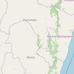
Geography guide, regional context, and park location map for Andringitra National Park

Andringitra National Park park geography, regions, and map view in Madagascar
Understand where Andringitra National Park sits in Madagascar through a broader geographic reading of the surrounding landscape, nearby location context, and its mapped position within the national park landscape.

How Andringitra National Park fits into Madagascar

Madagascar is an island nation in the Indian Ocean, positioned off the southeastern coast of Africa. As the world's fourth-largest island and second-largest island country, it stands out for its exceptional biodiversity, over 90% of its wildlife is endemic, making it one of 17 megadiverse countries. The population is approximately 32 million, with Antananarivo as both the capital and largest city.

Wider geography shaping Andringitra National Park in Madagascar

Madagascar lies in the Indian Ocean off the southeastern coast of Africa, separated from the mainland by the Mozambique Channel. The island is situated approximately 400 km from the African continent. As the world's fourth-largest island, it also includes numerous smaller peripheral islands.

Map view of Andringitra National Park

Use this park location map to pinpoint Andringitra National Park in Madagascar, understand its exact geographic position, and read its mapped placement within the surrounding landscape more clearly.

Pigeon | © OpenStreetMap contributors

Location context for Andringitra National Park

Haute Matsiatra
Park atlas

Trace the Regional Spread of Protected Geography and Nearby Conservation Landscapes from Andringitra

Explore Nearby National Parks and Protected Landscapes Around Andringitra National Park
Continue your exploration from Andringitra National Park by browsing other national parks and protected areas in the surrounding regions of Madagascar. This geographic overview allows you to compare diverse highland ecosystems, rainforests, and unique granite landscapes, understanding the broader context of conservation across the island.
National parkMadagascar

Ranomafana National Park: Madagascar's premier Tropical Rainforest Protected Area

Explore its unique mapped geography and landscape context.

Ranomafana National Park stands as a crucial national park within Madagascar's protected lands, safeguarding a significant expanse of tropical rainforest. This page offers a deep dive into its geographic setting, detailing the mapped boundaries and the distinctive natural terrain that supports its exceptional biodiversity. Discover the atlas value of this protected landscape for understanding regional conservation and geographic context.

Area
416 km²
Established
1991
IUCN
II
Climate
Tropical
National parkAtsimo-Atsinanana

Midongy du sud National Park: National Park in Atsimo-Atsinanana, Madagascar

Explore its protected landscape and mapped geography.

Midongy du sud National Park is a significant protected area located in the Atsimo-Atsinanana region of Madagascar. This entry provides detailed geographic context, focusing on the park's mapped boundaries and its identity as a national park. It supports atlas-based discovery by offering insights into the park's specific landscape and its regional setting within southeastern Madagascar, serving as a factual resource for understanding its protected status.

Area
1,922 km²
Established
1997
IUCN
II
Relief
Mountain
National parkIhorombe Region

Isalo National Park: Explore Madagascar's Sandstone Canyons and Protected Landscape Geography

Discover unique geology, tapia woodlands, and regional park context.

Isalo National Park is a prominent protected area in Madagascar's Ihorombe Region, celebrated for its spectacular sandstone landscape. This national park features deep canyons, eroded rock domes, and striking runiform mountains, formed from ancient sedimentary deposits. The park preserves significant tapia woodlands and remarkable plant endemism, offering a rich context for understanding protected land distribution and Madagascar's unique geography. Its mapped terrain provides a visual atlas of natural wonders.

Area
815.4 km²
Established
1962
IUCN
II
Visitors
32.7K annual
National parkAtsimo-Andrefana

Zombitse-Vohibasia National Park: Protected Landscape and Regional Geographic Context

Mapped protected areas and natural terrain discovery.

Investigate Zombitse-Vohibasia National Park, a designated national park within the Atsimo-Andrefana region. This dedicated entry provides detailed geographic information, focusing on the park's mapped terrain and its contribution to the regional protected landscape. Gain insight into the park's atlas-relevant features and its specific place within Madagascar's conservation geography.

Area
363.08 km²
Established
2002
IUCN
II
Relief
Upland
National parkMadagascar

Marolambo National Park: Madagascar's National Park and Protected Landscape

Explore mapped boundaries and regional geography.

Marolambo National Park stands as a protected national park within Madagascar's globally recognized biodiversity hotspot. This entry provides focused insight into its protected landscape, its specific geographic context within the island nation, and its role in the conservation of unique natural terrain. Understanding Marolambo National Park through its mapped boundaries and regional geography contributes to a broader atlas exploration of Madagascar's endemic ecosystems.

Area
950.63 km²
Climate
Tropical
Access
Remote access
Scope
Terrestrial
National parkMadagascar

Andohahela National Park: Protected Landscape and Geographic Atlas Context in Madagascar

Explore the mapped terrain and regional park geography.

Understand Andohahela National Park as a distinct national park entity, focusing on its geographic setting and protected landscape characteristics within Madagascar. This detail page provides structured data on the park's mapped boundaries and its regional importance, offering insights for anyone exploring protected areas and natural terrain through a geographic lens. It is an essential resource for understanding the park's specific context in the broader atlas.

Area
760 km²
Established
1998
IUCN
II
Visitors
1.3K annual
National parkMadagascar

Kirindy Mitea National Park: Madagascar National Park with Distinct Protected Landscape Identity

Explore the mapped geographic context of Kirindy Mitea National Park.

Kirindy Mitea National Park serves as a notable protected area, holding national park status within Madagascar's distinctive island geography. This entry focuses on understanding the park's unique protected landscape and its charted boundaries, offering essential context for atlas-driven exploration. Discover the geographic elements that define Kirindy Mitea National Park and its place within the broader conservation map of the region.

Area
1,563.5 km²
Established
1997
IUCN
IV
Relief
Mixed relief
National parkAlaotra-Mangoro

Andasibe-Mantadia National Park: National Park and Protected Landscape Identity

Explore its mapped boundaries and geographic context.

Andasibe-Mantadia National Park is a distinct protected territory within the Alaotra-Mangoro region, serving as a crucial focal point for understanding Madagascar's regional geography and protected land distribution. This detail page provides essential atlas-style information on the park's mapped area and its natural landscape characteristics. Engage with structured data that highlights the park's protected status and its position within the broader geographic framework of eastern Madagascar, supporting focused discovery for researchers and explorers.

Area
155 km²
Established
1989
IUCN
II
Visitors
26.1K annual

Common questions about visiting, size, designation, and location context for Andringitra National Park

Andringitra National Park FAQs for park facts, access, geography, and protected area context
Find quick answers about Andringitra National Park, including protected-area facts, park geography, trail and visitor context, and how the park fits into its surrounding country and regional landscape.
MoriAtlas Explorer

Continue Your Protected Areas Search Across the Global Atlas

Deepen your exploration by continuing the structured search for national parks and protected areas worldwide. Utilize the comprehensive filtering capabilities to compare different conservation landscapes and refine your understanding of global park geography. Discover more about the distribution and characteristics of protected natural areas.

Global natural geography