

Mori Atlas logo
National parkZombitse-Vohibasia National Park

Map your exploration of Zombitse-Vohibasia National Park's mapped boundaries and natural terrain.

Zombitse-Vohibasia National Park: Protected Area and Geographic Landscape Context in Atsimo-Andrefana

Delve into Zombitse-Vohibasia National Park, a significant protected natural area located within the Atsimo-Andrefana region of Madagascar. This page offers detailed geographic context, focusing on the park's mapped boundaries and its place within the regional landscape. Understand Zombitse-Vohibasia National Park as a distinct entity within the broader atlas of protected lands, perfect for structured geographic discovery and landscape analysis.

National ParkDry ForestEndemic SpeciesLemur HabitatImportant Bird AreaMadagascar

Zombitse-Vohibasia National Park

National park

Park overview

Structured park overview, official facts, and landscape profile for Zombitse-Vohibasia National Park

Zombitse-Vohibasia National Park park facts, protected area profile, and essential visitor context
Review the core facts for Zombitse-Vohibasia National Park, including designation, size, terrain, visitor scale, habitats, and operating context in one park-focused overview.

About Zombitse-Vohibasia National Park

Zombitse-Vohibasia National Park represents one of Madagascar's important protected areas in the island's southwestern dry forest region. The park comprises three non-contiguous forest parcels strategically positioned between two significant geological features: the Isalo massif to the east and a calcareous plateau to the west. The park's location along National Road 7 between Ihosy and Toliara makes it accessible to visitors traveling Madagascar's popular southern circuit. The surrounding landscape is inhabited by the Bara and Mahafaly ethnic groups, whose traditional land use practices have shaped the region's character. The park's elevation range of 300 to 825 meters supports diverse habitats including dense dry deciduous forest, transitional woodlands, and open grasslands. Unlike many protected areas in Madagascar, Zombitse-Vohibasia contains no permanent watercourses, though springs and small wetlands function as critical water reservoirs feeding tributaries of the Teheza and Fiherenana rivers. The geological substrate varies across sections, with the Zombitse area sitting on sandstone formations while Vohibasia and Isoky-Vohimena rest on Jurassic limestone bedrock.

Quick facts and research context for Zombitse-Vohibasia National Park

Zombitse-Vohibasia National Park covers 363.08 square kilometers in southwestern Madagascar's Atsimo-Andrefana region. The park is located along National Road 7 between the cities of Ihosy and Toliara, with the park office in Sakaraha approximately 10 kilometers from the entrance. The area experiences a semi-arid climate with an average temperature of 23.4 degrees Celsius and annual rainfall of 724 millimeters, with the wet season from November through March. The park falls within the Madagascar succulent woodlands ecoregion, assessed as Critical/Endangered, and is recognized as an Important Bird Area by BirdLife International. The Bara and Mahafaly people are the primary ethnic groups in the surrounding region.

Park context

Deeper park guide and search-rich context for Zombitse-Vohibasia National Park

Zombitse-Vohibasia National Park history, landscape, wildlife, and travel context
Explore Zombitse-Vohibasia National Park through its history, landscape character, ecosystems, wildlife, conservation priorities, cultural context, and seasonal travel timing in a structured park guide built for atlas discovery and search intent.

Why Zombitse-Vohibasia National Park stands out

Zombitse-Vohibasia National Park is most renowned for its exceptional endemism, particularly the Hubbard's sportive lemur (also called the Zombitse sportive lemur), a critically endangered species known only from this protected area. The park serves as a refuge for eight species of lemurs, including the endangered ring-tailed lemur and Verreaux's sifaka. With 90 recorded bird species including 38 endemics and the vulnerable Appert's tetraka, the park is a critical habitat for Madagascar's unique wildlife. The park also protects the distinctive Madagascar succulent woodlands ecosystem, a transitional habitat between spiny thicket and dry deciduous forest that supports extraordinary plant diversity with over 80 percent of vascular plant species endemic to Madagascar.

Zombitse-Vohibasia National Park history and protected-area timeline

The conservation history of Zombitse-Vohibasia reflects the evolution of Madagascar's protected area network. The Zombitse forest was first set aside as a protected area in 1962, representing one of the earlier conservation designations in this region of Madagascar. Additional forest parcels at Vohibasia and Isoky-Vohimena were incorporated into the protected area in 1997, expanding the site's ecological scope. The full site was formally elevated to national park status in 2002 under the management of Madagascar National Parks Association. This progression from a single forest reserve to a comprehensive national park paralleled growing recognition of the area's exceptional biodiversity value, particularly concerning species found nowhere else on Earth.

Zombitse-Vohibasia National Park landscape and geographic character

The landscape of Zombitse-Vohibasia National Park encompasses a mosaic of forest, woodland, grassland, and limited wetland habitats. The three non-contiguous parcels share general similarities, though Isoky-Vohimena sits on the shoulder of the Isalo massif and shares some plant species with Isalo National Park, including various Aloe species and Pachypodium rosulatum. The forest canopy reaches 10 to 16 meters in height, dominated by members of the Euphorbiaceae and Fabaceae families, with baobab trees emerging above the general canopy. The understory consists primarily of woody species with thick, sclerophyllous leaves from families including Sapindaceae, Anacardiaceae, and Burseraceae. The Vohibasia section develops a diverse understory during the rainy season dominated by annual Acanthaceae species. Woodlands form transitional zones between forest and grassland, featuring scattered shrubs and small trees. Wetlands, though not extensive, support Ravenea rivularis palms, Pandanus xerophyta, and various sedges, including the near-threatened aquatic plant Aponogeton decaryi.

Zombitse-Vohibasia National Park ecosystems, habitats, and plant life

The ecological character of Zombitse-Vohibasia is defined by its position within the Madagascar succulent woodlands ecoregion, a region assessed as Critical/Endangered due to high levels of habitat conversion and degradation. This ecoregion represents a transitional zone between the spiny thicket of western Madagascar and the dry deciduous woodlands of the south, creating a unique mosaic of succulent plants and dry forest. Botanical research beginning with Perrier de la Bâthie's collections in 1910 has documented nearly 300 plant species across 84 families, with over 80 percent of vascular plants endemic to Madagascar. The Spurge Family contributes 20 species while the pea family provides 33 species. Two plant species are known only from Zombitse-Vohibasia: Ampelosycios bosseri (Cucurbitaceae), Ivodea trichocarpa (Rutaceae), and the orchid Grammangis spectabilis. An additional 23 species are considered rare, known from only two to five sites across Madagascar.

Zombitse-Vohibasia National Park wildlife and species highlights

Zombitse-Vohibasia supports remarkable mammalian diversity with 20 recorded species, including eight lemur species representing both diurnal and nocturnal adaptations. The ring-tailed lemur and Verreaux's sifaka are listed as Endangered, while the red-fronted lemur maintains Near Threatened status. nocturnal lemurs include the gray mouse lemur, fat-tailed dwarf lemur, Coquerel's giant mouse lemur (Endangered), Hubbard's sportive lemur (Endangered), and the pale fork-marked lemur (Endangered). Hubbard's sportive lemur holds particular significance as it is known only from Zombitse-Vohibasia National Park and is listed on CITES Appendix I. Bird diversity includes 90 species with 38 endemics, notably the vulnerable Appert's tetraka. The park supports 33 reptile species including Standing's day gecko and eight amphibian species. Insect surveys reveal remarkable ant diversity with over 40 species in more than 20 genera, and several insect species have their type locality within the park.

Zombitse-Vohibasia National Park conservation status and protection priorities

Zombitse-Vohibasia faces significant conservation challenges, primarily from deforestation driven by slash-and-burn agriculture. Comparative analysis of aerial photographs from 1949 and 1994 reveals substantial declines in forested area, with vegetation also suffering degradation from fire, grazing, and selective browsing. The park's conservation significance derives from its role as a refuge for multiple critically endangered and endemic species, particularly the Hubbard's sportive lemur which occurs nowhere else. The Madagascar succulent woodlands ecoregion's Critical/Endangered status underscores the urgency of protecting remaining habitat fragments. The park meets BirdLife International criteria as an Important Bird Area, functioning as a biological reservoir of primary importance due to its position straddling the western and southern domains of Madagascar.

Zombitse-Vohibasia National Park cultural meaning and human context

The landscape surrounding Zombitse-Vohibasia is inhabited by the Bara and Mahafaly peoples, two of Madagascar's distinctive ethnic groups with traditional lifestyles connected to the land. The Bara people historically practiced pastoralism and agriculture, while the Mahafaly are known for their elaborate burial traditions and the distinctivealoalo funerary steles that mark their cultural identity. These communities have maintained connections to the forest areas that now fall within the national park, and their traditional land use practices have influenced the region's ecological character over generations.

Top sights and standout views in Zombitse-Vohibasia National Park

Zombitse-Vohibasia National Park offers exceptional opportunities to observe Madagascar's unique dry forest ecosystems and endemic wildlife. The park provides one of the most reliable locations for spotting the endangered Hubbard's sportive lemur, found nowhere else on Earth. Visitors can encounter diverse lemur species including ring-tailed lemurs and Verreaux's sifaka during both day and night walks through the forest. The park's position along National Road 7 makes it an accessible stop on Madagascar's southern tourism circuit, connecting visitors to the broader Isalo region. The distinctive baobab trees emerging above the forest canopy create iconic landscapes, while the transition between forest, woodland, and grassland habitats supports remarkable plant diversity with numerous endemic species.

Best time to visit Zombitse-Vohibasia National Park

The optimal time to visit Zombitse-Vohibasia National Park is during the cooler dry season from April through October, when temperatures are more comfortable for walking and wildlife viewing is facilitated by reduced vegetation density. The dry season from April to October corresponds with lower rainfall, making trails more accessible and wildlife easier to spot as animals concentrate around remaining water sources. The warmest months from November to March coincide with the rainy season, when heavy rainfall can make trails difficult and some areas less accessible, though this period supports lusher vegetation. The transition periods at the start and end of the rainy season offer a balance between green landscapes and manageable conditions. January, the wettest month averaging 187 millimeters of rain, presents the greatest challenges for park access.
Park location guide

Geography guide, regional context, and park location map for Zombitse-Vohibasia National Park

Zombitse-Vohibasia National Park park geography, regions, and map view in Madagascar
Understand where Zombitse-Vohibasia National Park sits in Madagascar through a broader geographic reading of the surrounding landscape, nearby location context, and its mapped position within the national park landscape.

How Zombitse-Vohibasia National Park fits into Madagascar

Madagascar is an island nation in the Indian Ocean, positioned off the southeastern coast of Africa. As the world's fourth-largest island and second-largest island country, it stands out for its exceptional biodiversity, over 90% of its wildlife is endemic, making it one of 17 megadiverse countries. The population is approximately 32 million, with Antananarivo as both the capital and largest city.

Wider geography shaping Zombitse-Vohibasia National Park in Madagascar

Madagascar lies in the Indian Ocean off the southeastern coast of Africa, separated from the mainland by the Mozambique Channel. The island is situated approximately 400 km from the African continent. As the world's fourth-largest island, it also includes numerous smaller peripheral islands.

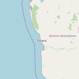
Map view of Zombitse-Vohibasia National Park

Use this park location map to pinpoint Zombitse-Vohibasia National Park in Madagascar, understand its exact geographic position, and read its mapped placement within the surrounding landscape more clearly.

Pigeon | © OpenStreetMap contributors

Location context for Zombitse-Vohibasia National Park

Atsimo-Andrefana
Park atlas

Trace protected landscapes and compare other significant natural areas in Madagascar's Atsimo-Andrefana region.

Discover Nearby National Parks and Protected Areas Around Zombitse-Vohibasia National Park
After exploring Zombitse-Vohibasia National Park, browse other national parks and protected areas within Madagascar, focusing on the unique succulent woodlands ecoregion and surrounding landscapes. Compare these conservation areas to understand the regional spread of diverse lemur habitats, dry forests, and endemic species across Madagascar's southwestern geography.
National parkIhorombe Region

Isalo National Park: Explore Madagascar's Sandstone Canyons and Protected Landscape Geography

Discover unique geology, tapia woodlands, and regional park context.

Isalo National Park is a prominent protected area in Madagascar's Ihorombe Region, celebrated for its spectacular sandstone landscape. This national park features deep canyons, eroded rock domes, and striking runiform mountains, formed from ancient sedimentary deposits. The park preserves significant tapia woodlands and remarkable plant endemism, offering a rich context for understanding protected land distribution and Madagascar's unique geography. Its mapped terrain provides a visual atlas of natural wonders.

Area
815.4 km²
Established
1962
IUCN
II
Visitors
32.7K annual
National parkMadagascar

Kirindy Mitea National Park: Madagascar National Park with Distinct Protected Landscape Identity

Explore the mapped geographic context of Kirindy Mitea National Park.

Kirindy Mitea National Park serves as a notable protected area, holding national park status within Madagascar's distinctive island geography. This entry focuses on understanding the park's unique protected landscape and its charted boundaries, offering essential context for atlas-driven exploration. Discover the geographic elements that define Kirindy Mitea National Park and its place within the broader conservation map of the region.

Area
1,563.5 km²
Established
1997
IUCN
IV
Relief
Mixed relief
National parkAtsimo-Atsinanana

Midongy du sud National Park: National Park in Atsimo-Atsinanana, Madagascar

Explore its protected landscape and mapped geography.

Midongy du sud National Park is a significant protected area located in the Atsimo-Atsinanana region of Madagascar. This entry provides detailed geographic context, focusing on the park's mapped boundaries and its identity as a national park. It supports atlas-based discovery by offering insights into the park's specific landscape and its regional setting within southeastern Madagascar, serving as a factual resource for understanding its protected status.

Area
1,922 km²
Established
1997
IUCN
II
Relief
Mountain
National parkHaute Matsiatra

Andringitra National Park: A Protected Landscape within Haute Matsiatra's Geography

Explore mapped park boundaries and regional terrain.

Andringitra National Park represents a vital protected area within the Haute Matsiatra region, contributing significantly to the mapped landscape of central Madagascar. Its designation as a national park underscores its importance for conservation and geographic study. Users exploring this destination can gain a detailed understanding of its specific protected boundaries, the surrounding natural terrain, and its overall contribution to the regional geography, making it a key site for atlas-based landscape discovery.

Area
311.6 km²
Established
1999
IUCN
II
Visitors
3.4K annual
National parkMadagascar

Andohahela National Park: Protected Landscape and Geographic Atlas Context in Madagascar

Explore the mapped terrain and regional park geography.

Understand Andohahela National Park as a distinct national park entity, focusing on its geographic setting and protected landscape characteristics within Madagascar. This detail page provides structured data on the park's mapped boundaries and its regional importance, offering insights for anyone exploring protected areas and natural terrain through a geographic lens. It is an essential resource for understanding the park's specific context in the broader atlas.

Area
760 km²
Established
1998
IUCN
II
Visitors
1.3K annual
Marine protected areaAtsimo-Andrefana

Nosy Ve-Androka National Park Marine Protected Area: Geographic and Atlas Discovery

Understand its marine landscape and regional geographic context.

Delve into Nosy Ve-Androka National Park, a critical marine protected area located in Madagascar's Atsimo-Andrefana region. This park offers a focused look at protected marine geography, allowing for detailed atlas exploration of its mapped boundaries and its role within the surrounding natural landscapes. Understand the specific geographic identity and conservation significance of this vital protected area through structured data.

Area
914.45 km²
Climate
Tropical
Access
Moderate access
Water
Water-dominated
National parkMadagascar

Ranomafana National Park: Madagascar's premier Tropical Rainforest Protected Area

Explore its unique mapped geography and landscape context.

Ranomafana National Park stands as a crucial national park within Madagascar's protected lands, safeguarding a significant expanse of tropical rainforest. This page offers a deep dive into its geographic setting, detailing the mapped boundaries and the distinctive natural terrain that supports its exceptional biodiversity. Discover the atlas value of this protected landscape for understanding regional conservation and geographic context.

Area
416 km²
Established
1991
IUCN
II
Climate
Tropical
National parkMadagascar

Marolambo National Park: Madagascar's National Park and Protected Landscape

Explore mapped boundaries and regional geography.

Marolambo National Park stands as a protected national park within Madagascar's globally recognized biodiversity hotspot. This entry provides focused insight into its protected landscape, its specific geographic context within the island nation, and its role in the conservation of unique natural terrain. Understanding Marolambo National Park through its mapped boundaries and regional geography contributes to a broader atlas exploration of Madagascar's endemic ecosystems.

Area
950.63 km²
Climate
Tropical
Access
Remote access
Scope
Terrestrial

Common questions about visiting, size, designation, and location context for Zombitse-Vohibasia National Park

Zombitse-Vohibasia National Park FAQs for park facts, access, geography, and protected area context
Find quick answers about Zombitse-Vohibasia National Park, including protected-area facts, park geography, trail and visitor context, and how the park fits into its surrounding country and regional landscape.
MoriAtlas Explorer

Continue Your Protected Areas Search Across the Global Atlas

Deepen your exploration by continuing the structured search for national parks and protected areas worldwide. Utilize the comprehensive filtering capabilities to compare different conservation landscapes and refine your understanding of global park geography. Discover more about the distribution and characteristics of protected natural areas.

Global natural geography