

Mori Atlas logo
Protected areaNosivolo River

Examining the ecological geography and catchment boundaries of a landmark eastern wetland system

Nosivolo River Protected Area: An Atlas of Madagascar’s Essential Freshwater Landscapes

(Rivière Nosivolo et affluents)

The Nosivolo River represents a critical protected landscape in eastern Madagascar, serving as a primary tributary to the Mangoro River. This detailed atlas entry traces the river’s descent from highland sources to its confluence at Marolambo, highlighting its status as an internationally recognized wetland. Users can examine the physical terrain and freshwater habitats that sustain unique endemic species within this conservation-focused catchment.

river ecosystemfreshwater biodiversityRamsar wetlandendemic fisheastern MadagascarMangoro tributary

Nosivolo River

Protected area

Park overview

Structured park overview, official facts, and landscape profile for Nosivolo River

Nosivolo River park facts, protected area profile, and essential visitor context

Review the core facts for Nosivolo River, including designation, size, terrain, visitor scale, habitats, and operating context in one park-focused overview.

About Nosivolo River

The Nosivolo River is one of the principal tributaries of the Mangoro River system in eastern Madagascar. It begins its course east of Fandriana, in the elevated landscapes of the country's central interior, and flows generally eastward through forested catchment before reaching the Mangoro. Along its path, it is joined by several notable tributaries, including the Sandranamby near the town of Marolambo, as well as the Sahadinta, Manandriana, and Sahanao rivers.

The surrounding region combines highland terrain, rainforest patches, and rural communities that have long relied on the river for transport, fishing, and daily life. Marolambo, situated at a key junction along the Nosivolo, serves as the administrative center of the Marolambo District within the Atsinanana region and reflects the close human connection to this watercourse. The river's course, running from roughly 1,800 meters in elevation at its source down to about 700 meters near its mouth, gives it a varied hydrological character and a range of aquatic habitats.

What distinguishes the Nosivolo most clearly is its ecological significance, which led to its designation in 2010 as Madagascar's first Ramsar site of river type. The designation, filed under the formal name "Rivière Nosivolo et affluents," drew attention to threatened freshwater species found nowhere else on Earth, including distinctive cichlids and the Malagasy rainbowfish. As a result, the Nosivolo has become a reference point for the conservation of Madagascar's often-overlooked freshwater ecosystems and the broader health of the Mangoro watershed.

Quick facts and research context for Nosivolo River

The Nosivolo River flows through eastern Madagascar, rising near Fandriana in the central highlands and joining the Mangoro River system. It runs roughly 130 kilometers in length and drains a basin of around 3,585 square kilometers. Marolambo, the capital of Marolambo District in the Atsinanana region, sits along its course.

In 2010, the Nosivolo was inscribed as Madagascar's first Ramsar wetland of river type, under the official designation "Rivière Nosivolo et affluents," giving the watercourse formal international recognition for its biodiversity and wetland values.

Protection and recognition

Documented terrestrial protection scope, designation history, and Ramsar wetland status

Nosivolo River Protection Status and International Recognition Data

Terrestrial protection status for Nosivolo River spans official designation history established in 2010 alongside recorded Ramsar recognition sources. Documented international recognition data outlines management scope and conservation standing without assuming specific ecological outcomes.

International recognition

Protection details

Protection scope
Terrestrial
Designated year
2010
Transboundary protection
No
Park context

Deeper park guide and search-rich context for Nosivolo River

Nosivolo River history, landscape, wildlife, and travel context

Explore Nosivolo River through its history, landscape character, ecosystems, wildlife, conservation priorities, cultural context, and seasonal travel timing in a structured park guide built for atlas discovery and search intent.

Why Nosivolo River stands out

The Nosivolo River is best known for being Madagascar's first river to receive Ramsar Wetland status, an international designation recognizing wetlands of global importance. This recognition was driven largely by the river's exceptional freshwater biodiversity, most notably its population of endemic cichlids, including Katria katria and Oxylapia polli, as well as the brightly colored Malagasy rainbowfish. The river's combination of highland source waters, intact forest cover along much of its course, and unique fish fauna has made it a landmark case for inland freshwater conservation in Madagascar. It also illustrates the link between the island's eastern forests and the broader Mangoro River basin.

Nosivolo River history and protected-area timeline

The Nosivolo River has long been a defining feature of the eastern Madagascar landscape, with communities along its banks, including Marolambo, depending on its waters for transport, fishing, and daily life. Historically, however, the river's ecological value went largely unrecognized at an international level, even as researchers began to document its unusual native fish fauna.

A turning point came on 17 September 2010, when the Nosivolo and its tributaries were formally designated as Madagascar's first Ramsar wetland of river type. The designation, recorded under the official name "Rivière Nosivolo et affluents" with reference number 1916, marked a major milestone in the country's conservation history. It highlighted the river's biodiversity, especially its endemic cichlids and rainbowfish, as values of global wetland significance.

This Ramsar listing helped raise awareness of inland freshwater habitats on the island and positioned the Nosivolo as a model for future river-focused conservation efforts in Madagascar.

Nosivolo River landscape and geographic character

The Nosivolo River runs through eastern Madagascar, cutting a path from the elevated interior down toward the Mangoro River basin. Its headwaters begin east of Fandriana at roughly 1,800 meters above sea level, and the river descends through a varied topography, reaching about 700 meters in elevation near its mouth.

The surrounding terrain blends elements of the central highlands with the forested slopes and valley systems typical of eastern Madagascar. Forests line significant portions of the catchment, while rural settlements, including the town of Marolambo at the confluence with the Sandranamby, occupy the more accessible stretches along the river.

The river's gradient, ranging from highland sources to lower-elevation lowlands, gives the Nosivolo a diverse physical character, with stretches of faster-moving water upstream and calmer sections nearer its confluence with the Mangoro. This range of conditions helps support the river's rich aquatic habitats.

Nosivolo River ecosystems, habitats, and plant life

The Nosivolo River's ecological importance lies primarily in its freshwater habitats. Its waters support a unique assemblage of native fish, including endemic cichlids such as Katria katria and Oxylapia polli, along with the colorful Malagasy rainbowfish. These species are largely restricted to Madagascar's eastern river systems, making the Nosivolo a key refuge for freshwater biodiversity that exists nowhere else.

Forested catchments along the river contribute to water quality and habitat continuity, allowing the river to retain much of its natural ecological character. The combination of highland source environments, varied flow conditions, and intact riparian vegetation supports an unusually rich aquatic community for a river of its size.

As part of the larger Mangoro watershed, the Nosivolo also plays an important role in regional ecological connectivity, linking highland forest landscapes with the broader eastern drainage network of Madagascar.

Nosivolo River wildlife and species highlights

The Nosivolo River is most noted for its freshwater wildlife, particularly its fish fauna. Several endemic cichlids, including Katria katria and Oxylapia polli, inhabit the river's waters. These cichlid species are part of Madagascar's distinctive evolutionary lineage of freshwater fish and are considered significant for both biodiversity and conservation.

The river is also home to the Malagasy rainbowfish, a brightly colored group of fish native to Madagascar's freshwater systems. Together with the cichlids, these species give the Nosivolo an unusually high level of endemic interest for a river of its size and helped underpin its international recognition.

While the river's most celebrated wildlife is aquatic, the surrounding forests and riparian habitats contribute to broader biodiversity in the catchment, supporting the ecological conditions that allow these specialist freshwater species to persist.

Nosivolo River conservation status and protection priorities

The Nosivolo River is an internationally recognized conservation site. On 17 September 2010, it became Madagascar's first Ramsar site of river type, designated under the official name "Rivière Nosivolo et affluents." This designation, recorded with reference number 1916 under the Ramsar Convention, formally recognizes the river and its tributaries as a wetland of global importance.

The river's conservation value rests heavily on its endemic freshwater biodiversity, especially its native cichlids and rainbowfish, many of which are found nowhere else. Protecting the Nosivolo is therefore considered important not only for Madagascar's inland freshwater ecosystems, but also for the global effort to safeguard unique fish lineages.

By serving as Madagascar's first river-focused Ramsar site, the Nosivolo has also played an important symbolic role, helping draw attention to inland freshwater conservation on an island more often associated with lemur and forest protection efforts.

Nosivolo River cultural meaning and human context

The Nosivolo River is woven into the daily life of communities in eastern Madagascar. The town of Marolambo, capital of the Marolambo District in the Atsinanana region, sits along the river at its junction with the Sandranamby, serving as a local administrative and cultural hub. The river's role in transport, fishing, and rural livelihoods has long shaped local identity in this part of the country.

As one of the principal tributaries of the Mangoro, the Nosivolo also connects highland and lowland communities along its course, supporting a shared dependence on the river across the catchment. The 2010 Ramsar designation brought new international recognition to a river whose cultural and ecological importance had long been appreciated locally.

Top sights and standout views in Nosivolo River

Madagascar's first Ramsar-listed river, recognized in 2010 for its exceptional freshwater biodiversity and intact catchment. The Nosivolo harbors endemic cichlids, including Katria katria and Oxylapia polli, along with the distinctive Malagasy rainbowfish, making it a focal point for inland freshwater conservation on the island. Stretching roughly 130 kilometers from the highlands near Fandriana to the Mangoro River, the Nosivolo combines ecological significance with a strong sense of local identity, anchored by the town of Marolambo at the Sandranamby confluence.

Best time to visit Nosivolo River

Madagascar's eastern river systems, including the Nosivolo catchment, are shaped by the island's tropical climate, with a wet season bringing heavier rainfall and higher river levels and a drier season offering calmer conditions and clearer water. For visitors interested in exploring the surrounding landscapes and human settlements such as Marolambo, the drier months generally offer more comfortable travel conditions and easier access to the river.

The wetter months bring lush vegetation and powerful river flows, making the catchment especially green but potentially more challenging to navigate. Wildlife observers and those interested in freshwater ecosystems may find the cooler, drier months particularly rewarding for seeing the region at its most accessible.
Monthly climate preview

Long term representative measurements tracking twelve month weather patterns in Atsinanana

Nosivolo River Climate Normals, Annual Temperature and Precipitation Rhythm

Representative coordinate records show average monthly temperatures ranging from 20.46 degrees Celsius to 25.76 degrees Celsius alongside distinct precipitation variations across the year. Reviewing the complete twelve month climate profile reveals detailed thermal ranges and monthly rainfall distributions for the protected area.
Annual mean23 °C
20 °C26 °C
Jan26°
Feb26°
Mar25°
Apr24°
May23°
Jun21°
Jul20°
Aug20°
Sep21°
Oct23°
Nov24°
Dec25°
Warmest month
January

25.8 °C

Coolest month
August

20.5 °C

Wettest month
February

11.6 mm/day

Driest month
September

1.6 mm/day

Park location guide

Geography guide, regional context, and park location map for Nosivolo River

Nosivolo River park geography, regions, and map view in Madagascar

Understand where Nosivolo River sits in Madagascar through a broader geographic reading of the surrounding landscape, nearby location context, and its mapped position within the national park landscape.

How Nosivolo River fits into Madagascar

Madagascar is an island nation in the Indian Ocean, positioned off the southeastern coast of Africa. As the world's fourth-largest island and second-largest island country, it stands out for its exceptional biodiversity, over 90% of its wildlife is endemic, making it one of 17 megadiverse countries. The population is approximately 32 million, with Antananarivo as both the capital and largest city.

Wider geography shaping Nosivolo River in Madagascar

Madagascar lies in the Indian Ocean off the southeastern coast of Africa, separated from the mainland by the Mozambique Channel. The island is situated approximately 400 km from the African continent. As the world's fourth-largest island, it also includes numerous smaller peripheral islands.

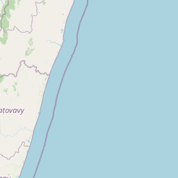
Map view of Nosivolo River

Use this park location map to pinpoint Nosivolo River in Madagascar, understand its exact geographic position, and read its mapped placement within the surrounding landscape more clearly.

Pigeon | © OpenStreetMap contributors

Location context for Nosivolo River

Atsinanana
Recorded earthquake history

View Recorded Seismic Activity Records for the Nosivolo River

Examine the historical catalogue of earthquakes associated with the Nosivolo River geography. MoriAtlas provides a clear, data-driven look at recorded seismic events documented near this protected eastern Madagascar river and its surrounding watershed.

Nosivolo River Earthquake History

Catalogued events

2 events

Strongest magnitude

Magnitude 4.8

Most recent event

May 13, 2020

This history includes earthquakes recorded inside the park or within 50 km of its borders

Park atlas

Compare adjacent river ecosystems and protected natural areas across eastern Madagascar

Explore Other Parks Near Nosivolo River And Regional Protected Landscapes

Browsing other parks near Nosivolo River reveals connected freshwater basins and upland protected landscapes across eastern Madagascar. Examining adjacent regional geography provides deeper context for freshwater conservation and river valley terrain.
National parkMadagascar
Mapped location lies within the park boundary#1 closest

West

Marolambo National Park: Madagascar's National Park and Protected Landscape

Explore mapped boundaries and regional geography.

Marolambo National Park stands as a protected national park within Madagascar's globally recognized biodiversity hotspot. This entry provides focused insight into its protected landscape, its specific geographic context within the island nation, and its role in the conservation of unique natural terrain. Understanding Marolambo National Park through its mapped boundaries and regional geography contributes to a broader atlas exploration of Madagascar's endemic ecosystems.

Area
950.63 km²
Climate
Tropical
Access
Remote access
Scope
Terrestrial
National parkMadagascar
72 km away#2 closest

Southwest

Ranomafana National Park: Madagascar's premier Tropical Rainforest Protected Area

Explore its unique mapped geography and landscape context.

Ranomafana National Park stands as a crucial national park within Madagascar's protected lands, safeguarding a significant expanse of tropical rainforest. This page offers a deep dive into its geographic setting, detailing the mapped boundaries and the distinctive natural terrain that supports its exceptional biodiversity. Discover the atlas value of this protected landscape for understanding regional conservation and geographic context.

Area
416 km²
Established
1991
IUCN
II
Climate
Tropical
Wildlife reserveAlaotra-Mangoro
About 104 km away#3 closest

North

Analamazaotra Forest Station: Protected Rainforest Landscapes in Alaotra-Mangoro, Madagascar

Community-managed wildlife reserve and humid forest habitat

Analamazaotra Forest Station represents a core protected area within the humid eastern rain forests of Madagascar. Managed through local partnership, the reserve functions as a hub for habitat restoration and biodiversity conservation. This site is integral to the regional landscape, preserving a continuous block of essential forest habitat along the eastern escarpment that supports a wide range of endemic species.

Area
7.1 km²
Relief
Upland
Climate
Tropical
Access
Access unknown
National parkAlaotra-Mangoro
About 104 km away#4 closest

North

Andasibe-Mantadia National Park: National Park and Protected Landscape Identity

Explore its mapped boundaries and geographic context.

Andasibe-Mantadia National Park is a distinct protected territory within the Alaotra-Mangoro region, serving as a crucial focal point for understanding Madagascar's regional geography and protected land distribution. This detail page provides essential atlas-style information on the park's mapped area and its natural landscape characteristics. Engage with structured data that highlights the park's protected status and its position within the broader geographic framework of eastern Madagascar, supporting focused discovery for researchers and explorers.

Area
155 km²
Established
1989
IUCN
II
Visitors
26.1K annual
National parkMadagascar
About 104 km away#5 closest

North

Mantadia National Park: Madagascar National Park and Protected Landscape Atlas

Mapped boundaries and regional geographic context of Mantadia.

Mantadia National Park represents a crucial protected landscape within Madagascar, detailed here for comprehensive geographic and atlas exploration. This entry focuses on its identity as a national park, providing insights into its mapped boundaries and its contribution to the understanding of Madagascar's diverse natural terrain. The information facilitates a structured discovery of the park's environmental and geographical significance, essential for anyone mapping protected areas.

Watercolor illustration of a landscape featuring mountains, a lake, trees, and pink flowers in the foreground
National parkAlaotra-Mangoro
About 104 km away#6 closest

North

Analamazaotra National Park: Protected Rainforest Ecosystem and Mapped Landscape in Alaotra-Mangoro

Explore Madagascar's Eastern Highlands protected area geography.

Analamazaotra National Park, situated in Madagascar's Alaotra-Mangoro region, represents a critical segment of the island's protected eastern rainforests. This national park is mapped as a vital conservation area, offering insights into its unique ecosystems and natural terrain. Understanding Analamazaotra National Park's geographic placement and protected boundaries provides essential context for regional landscape exploration and atlas-based geographic discovery within Madagascar.

Area
26.53 km²
Established
2015
IUCN
II
Relief
Highland
Wildlife reserveAtsinanana
About 194 km away#7 closest

North

Réserve spéciale de Mangerivola: Geographic Overview of an Atsinanana Wildlife Reserve

Rainforest topography and protected corridor mapping

Réserve spéciale de Mangerivola serves as a cornerstone of the eastern Malagasy rainforest corridor. This overview provides insight into the reserve's challenging, roadless terrain and its layered ecological composition, ranging from dense humid forests to rocky, high-altitude outcrops that sustain rare bird species and seven distinct lemur populations.

Area
130.05 km²
Established
1958
IUCN
IV
Relief
Upland
National parkHaute Matsiatra
205 km away#8 closest

Southwest

Andringitra National Park: A Protected Landscape within Haute Matsiatra's Geography

Explore mapped park boundaries and regional terrain.

Andringitra National Park represents a vital protected area within the Haute Matsiatra region, contributing significantly to the mapped landscape of central Madagascar. Its designation as a national park underscores its importance for conservation and geographic study. Users exploring this destination can gain a detailed understanding of its specific protected boundaries, the surrounding natural terrain, and its overall contribution to the regional geography, making it a key site for atlas-based landscape discovery.

Area
311.6 km²
Established
1999
IUCN
II
Visitors
3.4K annual

Common questions about visiting, size, designation, and location context for Nosivolo River

Nosivolo River FAQs for park facts, access, geography, and protected area context

Find quick answers about Nosivolo River, including protected-area facts, park geography, trail and visitor context, and how the park fits into its surrounding country and regional landscape.
MoriAtlas Explorer

Continue Your Protected Areas Search Across the Global Atlas

Deepen your exploration by continuing the structured search for national parks and protected areas worldwide. Utilize the comprehensive filtering capabilities to compare different conservation landscapes and refine your understanding of global park geography. Discover more about the distribution and characteristics of protected natural areas.

Global natural geography