

Mori Atlas logo
Wildlife reserveAnalamazaotra Forest Station

Examining the ecological boundaries, community-led conservation, and mapped terrain of Madagascar's eastern escarpment.

Analamazaotra Forest Station: A Protected Humid Rainforest Landscape in the Alaotra-Mangoro Region

Analamazaotra Forest Station serves as a critical community-managed wildlife reserve situated within the eastern humid forest block of Madagascar. This protected area, spanning across the Alaotra-Mangoro region, features a mosaic of mature rain forest and restored habitat that supports high concentrations of endemic wildlife. The terrain encompasses steep ridges and incised valleys, offering a distinct look into the biodiversity of the eastern escarpment.

rainforesthumid forestlemursIndricommunity-managed reservehabitat restoration

Analamazaotra Forest Station

Wildlife reserve

Park overview

Structured park overview, official facts, and landscape profile for Analamazaotra Forest Station

Analamazaotra Forest Station park facts, protected area profile, and essential visitor context

Review the core facts for Analamazaotra Forest Station, including designation, size, terrain, visitor scale, habitats, and operating context in one park-focused overview.

About Analamazaotra Forest Station

Analamazaotra Forest Station sits in the eastern escarpment zone of Madagascar, an area where steep forested hills and humid valleys have historically supported some of the most species-dense rain forest on the island. The station's 710 hectares combine old-growth humid forest with patches of degraded land that have been targeted for restoration, producing a patchwork mosaic of mature canopy, regenerating native vegetation, and buffer zones around the reserve edge.

Geographically, the station forms part of the broader Andasibe-Mantadia landscape, one of the most important protected-area complexes for rainforest biodiversity in Madagascar. Although each protected unit carries its own legal status, the contiguous forest across Analamazaotra, Mantadia, and the surrounding corridor supports the same broad set of species and helps maintain ecological processes like dispersal and seasonal movement.

What sets Analamazaotra apart from many strictly government-managed reserves in Madagascar is its community-based governance model. The station is run by Mitsinjo, a local community organization, through a management contract with the national Ministère des Eaux et Forets. This structure gives surrounding villages a direct stake in how the forest is protected and restored, and it has made the site an important case study in integrating conservation, reforestation, and local livelihoods. Long-running habitat restoration work has replanted large areas with native tree species, gradually rebuilding forest structure and function in formerly cleared zones.

For visitors, researchers, and conservationists alike, Analamazaotra offers a concentrated slice of Madagascar's eastern humid forest that is both scientifically important and unusually approachable. Trails through the station are short enough to allow detailed observation of primates, lemurs, tenrecs, and herpetofauna within a single day, while the reserve's proximity to Andasibe-Mantadia extends the range of possible sightings into a much larger landscape.

Quick facts and research context for Analamazaotra Forest Station

Analamazaotra Forest Station covers approximately 710 hectares of humid rain forest and restored habitat in east-central Madagascar. It lies within the Analamazaotra National Park complex and borders Andasibe-Mantadia National Park, together forming one of the largest protected forest blocks in the Alaotra-Mangoro region.

The area is administered through a community-based management contract between the local organization Mitsinjo and the national Ministère des Eaux et Forets, making it one of the better-known examples of community-managed conservation in Madagascar. It is internationally recognized for its primate populations, especially the Indri indri, and for an exceptionally rich assemblage of frogs, chameleons, tenrecs, and other endemic species.

Protection and recognition

Examine documented terrestrial conservation metrics and official recognition details.

Analamazaotra Forest Station Protection Status and Regional Designation Records

Analamazaotra Forest Station maintains a documented terrestrial protection scope within its regional landscape. Structured records detail available designation metrics, management frameworks, and administrative frameworks.

Protection details

Protection scope
Terrestrial
Transboundary protection
No
Park context

Deeper park guide and search-rich context for Analamazaotra Forest Station

Analamazaotra Forest Station history, landscape, wildlife, and travel context

Explore Analamazaotra Forest Station through its history, landscape character, ecosystems, wildlife, conservation priorities, cultural context, and seasonal travel timing in a structured park guide built for atlas discovery and search intent.

Why Analamazaotra Forest Station stands out

Analamazaotra is best known as one of the most accessible and reliable places in Madagascar to encounter the Indri indri, the country's largest living lemur. Several family groups of Indri live within the reserve, and at least two of those groups are habituated to the presence of people, making sung or whistled contact calls a regular experience for visitors walking the short trails from the forest station. Beyond the Indri, the forest station is recognized for an unusually dense concentration of endemic wildlife within a compact area, including mouse lemurs, dwarf lemurs, the aye-aye, and a remarkable diversity of tenrecs and chameleons. It is also notable as one of the more prominent community-managed conservation sites in the country, where habitat restoration, species recovery, and community involvement are tightly linked.

Analamazaotra Forest Station history and protected-area timeline

Analamazaotra Forest Station has its origins in the long history of state-managed forestry stations in Madagascar, which initially served timber and watershed protection functions. Over time, the orientation of these stations shifted from production toward conservation, particularly as the ecological importance of Madagascar's eastern rain forest became more widely recognized and as international attention grew around species like the Indri indri.

The defining moment in the station's modern history was the establishment of a co-management arrangement under which the local community organization Mitsinjo took on responsibility for day-to-day management of the site, working in partnership with the Ministère des Eaux et Forets. This model transformed the station from a centrally administered forestry post into a community-managed protected area, embedding local residents directly into patrols, reforestation, and ecotourism activities.

Habitat restoration has been a central thread of this more recent phase. Significant portions of the station are being replanted with native rainforest species in order to repair forest edges, reconnect fragments, and improve habitat quality for species that depend on continuous canopy. Restoration work and community engagement have run in parallel, turning the station into a working example of how ecological recovery and local development can be combined in Madagascar.

In 2011, Analamazaotra also gained wider international visibility when part of the BBC's Madagascar documentary series, presented by David Attenborough, was filmed at the station, including a well-known scene in which lowland streaked tenrecs cross a small forest stream.

Analamazaotra Forest Station landscape and geographic character

Analamazaotra Forest Station lies on the wet eastern slope of Madagascar's central highlands, a region characterized by steep forested ridges, deeply incised stream valleys, and persistent high humidity from the Indian Ocean trade winds. Elevations in this part of the country are moderate rather than extreme, but the topography creates abrupt transitions between valleys and ridge crests, which in turn supports a fine-grained mosaic of microhabitats.

The forest itself is lowland and mid-elevation humid rain forest, dominated by tall native trees forming a multi-layered canopy with a rich understory of palms, ferns, lianas, and shrubs. The rain forest character is reinforced by the area's climate, which delivers heavy rainfall across much of the year and supports lush ground vegetation, mossy tree trunks, and a network of small streams that wind through the reserve.

Large parts of the station have undergone restoration after earlier clearance or degradation. These restored zones are visually distinct from mature forest, often showing a younger, more open canopy structure, and they form a transitional belt between the older core forest and adjacent land. Within the broader landscape context, Analamazaotra's forests are continuous with those of Andasibe-Mantadia, creating one of the larger connected rainforest blocks along Madagascar's eastern escarpment.

Analamazaotra Forest Station ecosystems, habitats, and plant life

The forest at Analamazaotra belongs to Madagascar's eastern humid forest biome, an ecosystem with extremely high endemism and a long evolutionary history of isolation. Within this biome, the station occupies a humid lowland to submontane zone, where dense canopy, abundant lianas, and a thick leaf-litter layer support a wide range of vertebrate and invertebrate communities.

Habitat diversity within the station is unusually high for such a compact area. Closed-canopy rain forest, regenerating restored forest, forest edge, streamside vegetation, and small clearings all occur within walking distance of one another, and each supports different ecological assemblages. Fallen logs, root masses, and hollow trees contribute structural complexity that is critical for small mammals, reptiles, and amphibians.

The result is an ecological profile in which a very large number of species coexist in a relatively small footprint, with strong vertical structure in the canopy and continuous humidity on the forest floor. This ecological richness is the foundation for the station's reputation for both biodiversity research and visitor sightings.

Analamazaotra Forest Station wildlife and species highlights

The wildlife profile of Analamazaotra is dominated by its primate and small-mammal fauna, especially lemurs. The station supports at least seven groups of Indri indri, including two that are habituated to the presence of people, making it one of the most reliable places in Madagascar to observe this large, black-and-white lemur and to hear its far-carrying calls through the canopy. Smaller primates include mouse lemurs, hairy-eared dwarf lemurs, Cheirogaleus dwarf lemurs, common brown lemurs, gray gentle lemurs, small-toothed sportive lemurs, and the rare nocturnal aye-aye.

Tenrecs are a particular specialty of the station. At least six species are recorded in and around the reserve, including the common tailless tenrec, greater hedgehog tenrec, lowland streaked tenrec, mole-like rice tenrec, shrew tenrecs of the genus Microgale, and the amphibious aquatic tenrec, which is closely tied to forest streams. The lowland streaked tenrec was featured in a BBC documentary filmed at the station, with a memorable sequence showing individuals crossing a small forest stream.

Herpetofauna is exceptionally diverse. More than one hundred frog species have been recorded within a roughly 30 kilometer radius of the station, and the reserve itself is home to at least five species of chameleon, including the brown pygmy leaf chameleon, Parson's chameleon, short-horned chameleon, nose-horned chameleon, and short-nosed chameleon. The Madagascar tree boa is also present, contributing to the forest station's status as one of the richest small reserves in Madagascar for reptile and amphibian life.

Analamazaotra Forest Station conservation status and protection priorities

Analamazaotra's importance from a conservation perspective stems from a combination of biodiversity value, forest restoration, and governance model. As a humid forest reserve adjacent to Andasibe-Mantadia, it anchors part of one of the largest continuous blocks of eastern rainforest in Madagascar, providing essential habitat for species that depend on extensive, connected canopy.

The station's community-based management through the local organization Mitsinjo has become a significant conservation model in its own right. Under the management contract with the Ministère des Eaux et Forets, local communities are directly involved in forest patrols, reforestation, environmental education, and small-scale ecotourism. This has helped reduce some of the typical pressures from charcoal production, slash-and-burn agriculture, and illegal hunting that affect unprotected forest in the region.

Habitat restoration is at the heart of the station's conservation work. Large parts of the reserve have been replanted with native rainforest species in order to rebuild degraded areas, strengthen forest edges, and improve habitat connectivity. These efforts directly benefit species such as the Indri, whose populations depend on continuous, high-quality canopy, while also contributing to broader watershed and soil protection functions in the surrounding landscape.

The station's profile was raised internationally by the 2011 BBC Madagascar series, which drew attention to its tenrecs, lemurs, and forest habitats, and which underscored its role as both a working conservation site and a showcase for Madagascar's endemic wildlife.

Analamazaotra Forest Station cultural meaning and human context

Analamazaotra sits in a rural region of east-central Madagascar where forest resources have long been central to local livelihoods, including small-scale agriculture, hunting, and timber use. The shift toward community-based conservation reflects broader changes across Madagascar, where rural communities are increasingly being recognized as essential partners in protecting the country's remaining natural forests.

The community organization Mitsinjo represents this transition in practice. Through the management contract with the Ministère des Eaux et Forets, villagers take an active role in managing the forest station, with conservation activities linked to local employment, training, and benefit-sharing from ecotourism. This has helped shape a local identity around sustainable forest stewardship rather than purely extractive land use.

The forest itself also carries an emerging cultural significance tied to wildlife, particularly the Indri, whose distinctive calls are part of the soundscape of the surrounding villages. Conservation awareness, environmental education programs linked to the station, and the station's role as a destination for both national and international visitors have all contributed to strengthening the connection between local communities and the protected landscape that surrounds them.

Top sights and standout views in Analamazaotra Forest Station

Analamazaotra Forest Station is distinguished by the unusual combination of an exceptionally high concentration of endemic wildlife within a very small protected footprint. Its seven or more groups of Indri indri, including two habituated groups, make it one of the most rewarding single sites in Madagascar for primate viewing, while its tenrec and chameleon diversity make it equally compelling for visitors interested in lesser-known endemic groups.

Equally distinctive is its community-managed conservation model, which has turned the station into a working example of how restoration, biodiversity protection, and local livelihoods can be combined. Long-running reforestation projects are rebuilding forest structure in previously degraded areas, and the surrounding community is directly involved in managing and benefiting from the forest.

Its location within the broader Andasibe-Mantadia landscape, international recognition through the 2011 BBC Madagascar documentary, and accessibility from the regional road network all reinforce the station's profile as both a practical conservation site and an important point of contact between visitors and Madagascar's eastern rain forest.

Best time to visit Analamazaotra Forest Station

The eastern rain forest around Analamazaotra is green and biologically active throughout most of the year, so the reserve remains attractive across a wide range of seasons. Periods shortly after the main rains tend to feature especially lush vegetation, high humidity, and active amphibian and reptile behavior, while lemurs tend to remain active and visible so long as canopy cover holds.

Drier months generally bring cooler nights, slightly less humid forest conditions, and continued lemur activity, including regular Indri calling. Because much of the reserve's wildlife is sheltered beneath dense canopy, the forest retains its character even outside the wettest periods, and visitors can expect a strong experience of humid forest atmosphere and rainforest soundscape at any time of year that conditions allow access.
Monthly climate preview

Long term temperature and monthly precipitation records from 1991 to 2020

Analamazaotra Forest Station Climate Normals and Annual Weather Patterns

Analamazaotra Forest Station records measured monthly temperature and precipitation normals across a representative coordinate elevation of 992 meters. Reviewing the complete twelve month climate profile provides detailed historical patterns for average minimum and maximum temperatures throughout the year.
Annual mean18 °C
14 °C21 °C
Jan21°
Feb21°
Mar20°
Apr19°
May17°
Jun15°
Jul14°
Aug15°
Sep16°
Oct18°
Nov19°
Dec21°
Warmest month
January

20.9 °C

Coolest month
July

14.1 °C

Wettest month
February

14.8 mm/day

Driest month
September

3 mm/day

Park location guide

Geography guide, regional context, and park location map for Analamazaotra Forest Station

Analamazaotra Forest Station park geography, regions, and map view in Madagascar

Understand where Analamazaotra Forest Station sits in Madagascar through a broader geographic reading of the surrounding landscape, nearby location context, and its mapped position within the national park landscape.

How Analamazaotra Forest Station fits into Madagascar

Madagascar is an island nation in the Indian Ocean, positioned off the southeastern coast of Africa. As the world's fourth-largest island and second-largest island country, it stands out for its exceptional biodiversity, over 90% of its wildlife is endemic, making it one of 17 megadiverse countries. The population is approximately 32 million, with Antananarivo as both the capital and largest city.

Wider geography shaping Analamazaotra Forest Station in Madagascar

Madagascar lies in the Indian Ocean off the southeastern coast of Africa, separated from the mainland by the Mozambique Channel. The island is situated approximately 400 km from the African continent. As the world's fourth-largest island, it also includes numerous smaller peripheral islands.

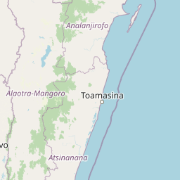
Map view of Analamazaotra Forest Station

Use this park location map to pinpoint Analamazaotra Forest Station in Madagascar, understand its exact geographic position, and read its mapped placement within the surrounding landscape more clearly.

Pigeon | © OpenStreetMap contributors

Location context for Analamazaotra Forest Station

Alaotra-Mangoro
Park atlas

Compare adjacent rainforest reserves and connected habitats across the eastern escarpment

Parks near Analamazaotra Forest Station and Surrounding Protected Landscapes

Browse protected areas and connected rainforest reserves situated directly around Analamazaotra Forest Station. Comparing adjacent eastern highland habitats provides deeper geographic context for regional biodiversity corridors.
National parkAlaotra-Mangoro
About 1.3 km away#1 closest

East

Andasibe-Mantadia National Park: National Park and Protected Landscape Identity

Explore its mapped boundaries and geographic context.

Andasibe-Mantadia National Park is a distinct protected territory within the Alaotra-Mangoro region, serving as a crucial focal point for understanding Madagascar's regional geography and protected land distribution. This detail page provides essential atlas-style information on the park's mapped area and its natural landscape characteristics. Engage with structured data that highlights the park's protected status and its position within the broader geographic framework of eastern Madagascar, supporting focused discovery for researchers and explorers.

Area
155 km²
Established
1989
IUCN
II
Visitors
26.1K annual
National parkMadagascar
About 1.3 km away#2 closest

East

Mantadia National Park: Madagascar National Park and Protected Landscape Atlas

Mapped boundaries and regional geographic context of Mantadia.

Mantadia National Park represents a crucial protected landscape within Madagascar, detailed here for comprehensive geographic and atlas exploration. This entry focuses on its identity as a national park, providing insights into its mapped boundaries and its contribution to the understanding of Madagascar's diverse natural terrain. The information facilitates a structured discovery of the park's environmental and geographical significance, essential for anyone mapping protected areas.

Watercolor illustration of a landscape featuring mountains, a lake, trees, and pink flowers in the foreground
National parkAlaotra-Mangoro
About 2.7 km away#3 closest

East

Analamazaotra National Park: Protected Rainforest Ecosystem and Mapped Landscape in Alaotra-Mangoro

Explore Madagascar's Eastern Highlands protected area geography.

Analamazaotra National Park, situated in Madagascar's Alaotra-Mangoro region, represents a critical segment of the island's protected eastern rainforests. This national park is mapped as a vital conservation area, offering insights into its unique ecosystems and natural terrain. Understanding Analamazaotra National Park's geographic placement and protected boundaries provides essential context for regional landscape exploration and atlas-based geographic discovery within Madagascar.

Area
26.53 km²
Established
2015
IUCN
II
Relief
Highland
Wildlife reserveAtsinanana
About 98 km away#4 closest

Northeast

Réserve spéciale de Mangerivola: Geographic Overview of an Atsinanana Wildlife Reserve

Rainforest topography and protected corridor mapping

Réserve spéciale de Mangerivola serves as a cornerstone of the eastern Malagasy rainforest corridor. This overview provides insight into the reserve's challenging, roadless terrain and its layered ecological composition, ranging from dense humid forests to rocky, high-altitude outcrops that sustain rare bird species and seven distinct lemur populations.

Area
130.05 km²
Established
1958
IUCN
IV
Relief
Upland
Protected areaAtsinanana
About 104 km away#5 closest

South

Nosivolo River Protected Area: A Geographic Profile of Madagascar’s Wetland Landscape

Freshwater habitat mapping and catchment geography

Investigate the physical geography of the Nosivolo River, a protected area in Madagascar characterized by its intact highland forest sources and diverse aquatic habitats. This profile provides context on the river’s role as a Ramsar-designated wetland and its function within the wider Mangoro River basin in the Atsinanana region.

Established
2010
Relief
Mixed relief
Scope
Terrestrial
Water
Water-dominated
National parkMadagascar
About 134 km away#6 closest

North

Zahamena National Park: Madagascar National Park Exploration and Geographic Context

Mapping the protected boundaries and landscape of Zahamena National Park.

Delve into Zahamena National Park, a vital protected territory situated in Madagascar. This national park offers a unique perspective on the island's natural geography and its status as a significant protected landscape. Understand its position within Madagascar's broader context, focusing on the mapped aspects of its protected area identity and its contribution to the country's renowned biodiversity hotspot status.

Area
423 km²
Established
1997
IUCN
II
Relief
Mountain
National parkMadagascar
About 141 km away#7 closest

Southwest

Marolambo National Park: Madagascar's National Park and Protected Landscape

Explore mapped boundaries and regional geography.

Marolambo National Park stands as a protected national park within Madagascar's globally recognized biodiversity hotspot. This entry provides focused insight into its protected landscape, its specific geographic context within the island nation, and its role in the conservation of unique natural terrain. Understanding Marolambo National Park through its mapped boundaries and regional geography contributes to a broader atlas exploration of Madagascar's endemic ecosystems.

Area
950.63 km²
Climate
Tropical
Access
Remote access
Scope
Terrestrial
Nature reserveAlaotra-Mangoro
About 142 km away#8 closest

North

Ankeniheny-Zahamena Corridor: Nature Reserve Landscape and Regional Geography

Mapping the central rainforest belt of the Alaotra-Mangoro region

Spanning over 3,800 square kilometers, the Ankeniheny-Zahamena Corridor stands as a cornerstone of Malagasy conservation. This reserve integrates diverse humid forest habitats into a single functioning landscape, providing a critical haven for endemic flora and threatened primates. Its role as a major watershed catchment reinforces its environmental importance for surrounding communities across eastern and western Madagascar.

Area
3,810 km²
Established
2007
IUCN
VI
Relief
Mixed relief

Common questions about visiting, size, designation, and location context for Analamazaotra Forest Station

Analamazaotra Forest Station FAQs for park facts, access, geography, and protected area context

Find quick answers about Analamazaotra Forest Station, including protected-area facts, park geography, trail and visitor context, and how the park fits into its surrounding country and regional landscape.
MoriAtlas Explorer

Continue Your Protected Areas Search Across the Global Atlas

Deepen your exploration by continuing the structured search for national parks and protected areas worldwide. Utilize the comprehensive filtering capabilities to compare different conservation landscapes and refine your understanding of global park geography. Discover more about the distribution and characteristics of protected natural areas.

Global natural geography