

Mori Atlas logo
National parkZahamena National Park

Mapping the protected landscape and regional context of Zahamena National Park.

Zahamena National Park: A Protected National Park in Madagascar's Unique Geography

Zahamena National Park represents a significant protected area within Madagascar, an island nation renowned for its exceptional biodiversity and unique geographic formations. As a designated national park, Zahamena offers a focused lens into the island's natural heritage, contributing to the broader atlas of conservation landscapes. This page provides essential geographic context, detailing the park's location and its role as a distinct protected territory within the vast Indian Ocean landscape.

RainforestLemursEndemic BirdsUNESCO World HeritageEastern MadagascarWetland Adjacent

Zahamena National Park

National park

Park overview

Structured park overview, official facts, and landscape profile for Zahamena National Park

Zahamena National Park park facts, protected area profile, and essential visitor context
Review the core facts for Zahamena National Park, including designation, size, terrain, visitor scale, habitats, and operating context in one park-focused overview.

About Zahamena National Park

Zahamena National Park represents one of the most biologically significant protected areas in Madagascar, a country recognized globally for its extraordinary endemism. The park's inclusion in the UNESCO World Heritage Site of the Rainforests of the Atsinanana reflects its irreplaceable value as a repository of species found nowhere else on Earth. The park's landscape is characterized by steep, undulating terrain that forms part of the mountainous hinterland of eastern Madagascar, creating a natural dividing line between coastal lowlands and higher elevation zones. This topographic complexity has fostered the development of distinct vegetation zones that transition from lowland humid evergreen forest through mid-altitude forest to sclerophyllous montane forest as elevation increases. The forest ecosystem remains remarkably intact despite surrounding agricultural pressure, with 99 percent of the park area retaining forest cover.

The park's isolation and difficult access have paradoxically served as protection, limiting development pressure and preserving ecological integrity. The two-zone structure, with settled villages occupying the corridor between eastern and western sections, reflects the traditional land use patterns that predate formal protection. Climate patterns feature wet conditions typical of eastern Madagascar, with annual rainfall supporting the rainforest ecosystem. The river systems draining the park, particularly those flowing toward Lake Alaotra on the northwest side, connect the protected area to broader ecological processes beyond its boundaries.

Quick facts and research context for Zahamena National Park

Zahamena National Park occupies 423 km² of northeastern Madagascar within the Atsinanana rainforest region. Established in 1997, it is managed by Madagascar National Parks and forms part of the UNESCO World Heritage-listed Rainforests of the Atsinanana. The park features rugged topography with elevations from 254m to 1,560m, traversed by rivers including the Sahatavy River and Sarondrina River that drain toward Lake Alaotra. Annual rainfall ranges from 180 to 200 centimetres with average temperatures between 15°C and 28°C. The protected area is divided into eastern and western zones separated by a corridor of settled villages, with the park office located at Antanandava.

Park context

Deeper park guide and search-rich context for Zahamena National Park

Zahamena National Park history, landscape, wildlife, and travel context
Explore Zahamena National Park through its history, landscape character, ecosystems, wildlife, conservation priorities, cultural context, and seasonal travel timing in a structured park guide built for atlas discovery and search intent.

Why Zahamena National Park stands out

Zahamena is especially known for its extraordinary concentration of endemic biodiversity. The park harbours the highest number of endemic bird species in Madagascar at 67 species, alongside 13 lemur species including the critically endangered indri (Indri indri), the diademed sifaka, and the black-and-white ruffed lemur. It is one of only two known habitats of the endangered Lake Alaotra bamboo lemur. The park also protects rare species such as the Madagascar red owl (Tyto soumagnei), the Madagascar serpent eagle (Eutriorchis Asturias), and the aye-aye. The presence of 500 or more woody plant species, 60 orchid species, and 20 palm species further underscores its botanical significance within the island's eastern rainforest corridor.

Zahamena National Park history and protected-area timeline

Zahamena National Park was officially established in 1997 as part of Madagascar's expanding network of protected areas during a period of increased recognition of the island's global biodiversity significance. The park was created as a formal national park under the management of Madagascar National Parks (Association Nationale pour la Gestion des Aires Protégées), the primary institution responsible for administering the country's protected area network. In 2007, the park gained international recognition as part of the Rainforests of the Atsinanana, which was inscribed as a UNESCO World Heritage Site based on criteria (ix) and (x) relating to ecological processes and conservation of biodiversity. This serial site encompasses 13 specific areas across eight national parks in eastern Madagascar, acknowledging the collective importance of the rainforest corridor. Prior to formal protection, the area had been subject to varying degrees of local use and management by surrounding communities, particularly the Betsimisaraka and Sihanak peoples. The establishment process involved defining boundaries and implementing management structures, with the park administration headquartered at Antanandava.

Zahamena National Park landscape and geographic character

The physical landscape of Zahamena National Park is defined by rugged, undulating topography characteristic of the eastern highlands of Madagascar. Elevations within the park range from 254 metres in the lower valleys to 1,560 metres along the higher ridgelines, creating a diverse altitudinal gradient that supports multiple forest types. The terrain features steep rock faces, deep valleys, and rolling hills that collectively form the mountainous backdrop separating Madagascar's eastern coastal lowlands from the central highlands. The park's boundaries are well-defined along the northeastern and southwestern edges, while the interior is dissected by numerous valleys carved by rivers flowing through the protected area.

The hydrological network includes the Sahatavy River, the Sarondrina River, and several smaller watercourses that drain the park's interior. On the northwestern side, these river systems converge and flow toward Lake Alaotra, Madagascar's largest lake and an important wetland ecosystem. The park is divided into two primary zones by a corridor where villages have been established, creating a pattern of protected forest interspersed with human settlement. This landscape configuration creates both challenges for conservation and opportunities for community-based natural resource management. The combination of elevation range, topographic complexity, water systems, and forest cover creates a visually distinctive landscape within Madagascar's eastern rainforest region.

Zahamena National Park ecosystems, habitats, and plant life

The ecological character of Zahamena is defined by its humid evergreen rainforests, which represent some of the finest remaining forest in Madagascar. At lower elevations, typically below 800 metres, the forest consists of a closed canopy reaching 15 to 20 metres in height, with occasional emergent trees reaching 25 metres. The canopy is dominated by species including Tambourissa, Pterophylla, Diospyros, Cryptocarya agathophylla, and Dalbergia. The understory contains tree ferns, screw ferns, and Pandanus species, while the forest floor supports diverse herbaceous vegetation including Impatiens, Begonia, and various fern species such as Polystichum. As elevation increases, the forest transitions to dense, humid evergreen formations and eventually to sclerophyllous montane forest at the highest elevations.

The botanical diversity is exceptional, with approximately 500 or more woody plant species recorded, alongside 60 orchid species and 20 palm species. Two particularly notable endemic floral species are Marattia boivinii (locally known as kobila) and Blotella coursii (fanjana malemy). The park also contains secondary forest areas resulting from past disturbance, though the vast majority of the protected area retains primary forest character. This botanical richness forms the foundation for the park's extraordinary animal diversity, creating the habitat conditions that support Madagascar's unique terrestrial fauna.

Zahamena National Park wildlife and species highlights

The wildlife of Zahamena National Park exemplifies Madagascar's global significance for biodiversity conservation, with the park supporting an extraordinary concentration of endemic species. The mammalian fauna includes 48 species, of which 13 are lemurs representing multiple families of Malagasy primates. Notable lemur species include the diademed sifaka (Propithecus diadema), black-and-white ruffed lemur (Varecia variegata), indri (Indri indri), hairy-eared dwarf lemur (Allocebus trichotis), and the critically endangered Lake Alaotra bamboo lemur (Hapalemur alaotrensis). The aye-aye (Daubentonia madagascariensis), one of the world's rarest and most unusual primates, is also present. Of these species, 22 are classified as threatened, including 8 critically endangered, 9 endangered, and 5 vulnerable.

The avifauna is particularly exceptional, with 112 bird species recorded, of which 67 are endemic to Madagascar, the highest number of endemic bird species in any protected area in the country. Notable species include the Madagascar serpent eagle (Eutriorchis Asturias), one of the world's rarest raptors, the Madagascar red owl (Tyto soumagnei), helmet vanga (Euryceros prevostii), and numerous ground rollers, vangas, and asities. The reptile fauna comprises 46 species, while the amphibian fauna includes 62 species. Fish diversity encompasses 29 species. This extraordinary species richness, combined with the high proportion of endemics and the presence of globally threatened species, makes Zahamena one of the most important conservation areas in Madagascar.

Zahamena National Park conservation status and protection priorities

Zahamena National Park faces significant conservation challenges despite its protected status and UNESCO World Heritage designation. The primary threats originate from the surrounding human population, whose agricultural practices include slash-and-burn cultivation that encroaches into forest edges. Low agricultural yields from farmland adjacent to the park drive local communities to exploit park resources, including hunting wildlife for sustenance and logging precious timber species such as rosewood and ebony. Fire use, poaching, and to a lesser extent gemstone mining also contribute to pressure on the park's biodiversity. These threats are particularly concentrated in the centre, east, and north of the protected area.

The park is managed by Madagascar National Parks with support from international conservation organizations including the Wildlife Conservation Society, Conservation International, and the IUCN. The area has been identified as a WWF Global 200 priority ecoregion, drawing additional international attention and resources. A Landscape Development Interventions Program operates in the park, focusing on protecting the highland rainforest corridor connecting Zahamena to Andasibe-Mantadia National Park while simultaneously addressing rural poverty through agricultural intensification and sustainable natural resource management. Progress in reducing threats and implementing conservation measures has been reported as positive, though ongoing vigilance and community engagement remain essential for long-term protection.

Zahamena National Park cultural meaning and human context

The human dimension of Zahamena National Park is shaped by the presence of local communities, primarily belonging to the Betsimisaraka and Sihanak ethnic groups, who have inhabited the region for generations. These communities maintain traditional patterns of land use that predate the establishment of formal protected area status. The park is divided by a corridor of settled villages that separates eastern and western zones, reflecting the historical presence of human communities within what is now designated as protected forest. This integration of human settlement and protected area creates both management complexities and opportunities for community-based conservation approaches.

The local communities derive their livelihoods from agriculture and natural resource use, activities that have brought them into potential conflict with conservation objectives. The conservation program acknowledges this reality by incorporating community participation in natural resource management and seeking to improve agricultural productivity as part of broader landscape-level interventions. Cultural practices and traditional knowledge of the landscape remain relevant to understanding the park's historical context and developing effective management strategies that balance biodiversity protection with community welfare.

Top sights and standout views in Zahamena National Park

Zahamena National Park stands out as one of Madagascar's most biodiversity-rich protected areas, securing the highest concentration of endemic bird species in the country alongside exceptional lemur diversity. The park protects critical habitat for the indri, Madagascar's largest lemur, as well as the elusive aye-aye and the rare Lake Alaotra bamboo lemur. The UNESCO World Heritage status acknowledges the park's role in conserving the Rainforests of the Atsinanana, one of the world's most threatened forest ecosystems. Exceptional botanical diversity, with over 500 woody plant species and 60 orchids, underpins the ecological richness. The park's relative remoteness has limited tourism, preserving wilderness character while presenting challenges for visitor access. The presence of rare species including the Madagascar serpent eagle and Madagascar red owl adds to the park's conservation significance.

Best time to visit Zahamena National Park

The optimal time to visit Zahamena National Park is during the cooler dry season from May to October, when conditions are most favourable for wildlife viewing and forest exploration. During this period, vegetation is less dense and animals congreg more visibly around water sources, enhancing observation opportunities. The dry weather also makes walking trails more accessible and comfortable for hikers exploring the park's rugged terrain. The wet season from November to March brings heavier rainfall, which can make trails slippery and some areas difficult to access, though the forest is at its most lush and waterfalls are most impressive. Bird activity remains high year-round given the consistent tropical climate, but the dry season generally offers better overall conditions for a comprehensive park visit.
Park location guide

Geography guide, regional context, and park location map for Zahamena National Park

Zahamena National Park park geography, regions, and map view in Madagascar
Understand where Zahamena National Park sits in Madagascar through a broader geographic reading of the surrounding landscape, nearby location context, and its mapped position within the national park landscape.

How Zahamena National Park fits into Madagascar

Madagascar is an island nation in the Indian Ocean, positioned off the southeastern coast of Africa. As the world's fourth-largest island and second-largest island country, it stands out for its exceptional biodiversity, over 90% of its wildlife is endemic, making it one of 17 megadiverse countries. The population is approximately 32 million, with Antananarivo as both the capital and largest city.

Wider geography shaping Zahamena National Park in Madagascar

Madagascar lies in the Indian Ocean off the southeastern coast of Africa, separated from the mainland by the Mozambique Channel. The island is situated approximately 400 km from the African continent. As the world's fourth-largest island, it also includes numerous smaller peripheral islands.

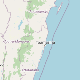
Map view of Zahamena National Park

Use this park location map to pinpoint Zahamena National Park in Madagascar, understand its exact geographic position, and read its mapped placement within the surrounding landscape more clearly.

Pigeon | © OpenStreetMap contributors
Park atlas

Trace contiguous rainforest landscapes and compare diverse protected areas within Madagascar's eastern highlands.

Discover Other National Parks and Protected Areas Surrounding Zahamena National Park in Eastern Madagascar
Explore national parks and protected areas geographically related to Zahamena National Park, tracing contiguous rainforest landscapes and diverse mountainous terrain across eastern Madagascar. This allows for a deeper atlas-style comparison of protected zones, revealing their ecological connections and regional conservation significance within the broader UNESCO World Heritage site.
Watercolor illustration of a landscape featuring mountains, a lake, trees, and pink flowers in the foreground
National parkAlaotra-Mangoro

Analamazaotra National Park: Protected Rainforest Ecosystem and Mapped Landscape in Alaotra-Mangoro

Explore Madagascar's Eastern Highlands protected area geography.

Analamazaotra National Park, situated in Madagascar's Alaotra-Mangoro region, represents a critical segment of the island's protected eastern rainforests. This national park is mapped as a vital conservation area, offering insights into its unique ecosystems and natural terrain. Understanding Analamazaotra National Park's geographic placement and protected boundaries provides essential context for regional landscape exploration and atlas-based geographic discovery within Madagascar.

Area
26.53 km²
Established
2015
IUCN
II
Relief
Highland
National parkAlaotra-Mangoro

Andasibe-Mantadia National Park: National Park and Protected Landscape Identity

Explore its mapped boundaries and geographic context.

Andasibe-Mantadia National Park is a distinct protected territory within the Alaotra-Mangoro region, serving as a crucial focal point for understanding Madagascar's regional geography and protected land distribution. This detail page provides essential atlas-style information on the park's mapped area and its natural landscape characteristics. Engage with structured data that highlights the park's protected status and its position within the broader geographic framework of eastern Madagascar, supporting focused discovery for researchers and explorers.

Area
155 km²
Established
1989
IUCN
II
Visitors
26.1K annual
National parkBoeny Region

Ankarafantsika National Park: Protected Area Atlas and Regional Geography Discovery

Explore mapped boundaries and natural landscape context.

Ankarafantsika National Park serves as a key protected area for understanding the geography of Madagascar's Boeny Region. This canonical page offers a detailed atlas-style view, highlighting the park's mapped boundaries and its role as a distinct natural landscape. Engage with structured geographic data to comprehend the park's protected status and its contribution to the regional terrain, facilitating a deeper appreciation of protected lands.

Area
1,365.13 km²
Established
2002
IUCN
II
Relief
Lowland
National parkMadagascar

Marolambo National Park: Madagascar's National Park and Protected Landscape

Explore mapped boundaries and regional geography.

Marolambo National Park stands as a protected national park within Madagascar's globally recognized biodiversity hotspot. This entry provides focused insight into its protected landscape, its specific geographic context within the island nation, and its role in the conservation of unique natural terrain. Understanding Marolambo National Park through its mapped boundaries and regional geography contributes to a broader atlas exploration of Madagascar's endemic ecosystems.

Area
950.63 km²
Climate
Tropical
Access
Remote access
Scope
Terrestrial
Watercolor painting of a mountainous landscape with green vegetation, a body of water, and distant peaks under a light sky
National parkMadagascar

Marojejy National Park: A Protected National Park within Madagascar's Unique Geography

Mapped landscape context and regional protected area significance.

Marojejy National Park is a distinct protected area offering rich insights into Madagascar's natural geography. As a national park, its mapped boundaries define a significant landscape that contributes to the island nation's reputation as a biodiversity hotspot. This entry provides essential context for understanding Marojejy National Park's role within the country's protected lands and its value for structured geographic atlas exploration.

Area
555 km²
Established
1998
IUCN
II
Relief
Mountain
National parkMadagascar

Ranomafana National Park: Madagascar's premier Tropical Rainforest Protected Area

Explore its unique mapped geography and landscape context.

Ranomafana National Park stands as a crucial national park within Madagascar's protected lands, safeguarding a significant expanse of tropical rainforest. This page offers a deep dive into its geographic setting, detailing the mapped boundaries and the distinctive natural terrain that supports its exceptional biodiversity. Discover the atlas value of this protected landscape for understanding regional conservation and geographic context.

Area
416 km²
Established
1991
IUCN
II
Climate
Tropical
National parkBoeny

Baie de Baly National Park: Mapped Boundaries and Protected Landscape Context

Explore the geography and natural terrain of this national park.

Baie de Baly National Park presents a critical focal point for understanding protected areas within the Boeny region. As a national park, it showcases specific mapped boundaries that contribute to the broader geographic understanding of Madagascar's conservation landscapes. This detailed view allows for an atlas-driven exploration of the park's natural terrain and its significance as a distinct protected landmass within its regional context.

Area
571.42 km²
Established
1997
IUCN
II
Climate
Tropical
National parkMelaky

Tsingy de Bemaraha National Park: A Protected Landscape within Melaky, Madagascar

Explore mapped boundaries and regional geography for atlas discovery.

Tsingy de Bemaraha National Park is a designated national park offering profound opportunities for geographic discovery. As a key protected area in the Melaky region, its mapped boundaries and natural landscape characteristics are vital for understanding Madagascar's conservation geography. This resource facilitates detailed atlas exploration, providing structured insights into the park's terrain and its position within the broader regional context, enabling a focused study of its protected land identity.

Area
723.4 km²
Established
1997
IUCN
II
Visitors
10.1K annual

Common questions about visiting, size, designation, and location context for Zahamena National Park

Zahamena National Park FAQs for park facts, access, geography, and protected area context
Find quick answers about Zahamena National Park, including protected-area facts, park geography, trail and visitor context, and how the park fits into its surrounding country and regional landscape.
MoriAtlas Explorer

Continue Your Protected Areas Search Across the Global Atlas

Deepen your exploration by continuing the structured search for national parks and protected areas worldwide. Utilize the comprehensive filtering capabilities to compare different conservation landscapes and refine your understanding of global park geography. Discover more about the distribution and characteristics of protected natural areas.

Global natural geography