
Mori Atlas logo
Nature reserveOstheimer Hute

A vital protected area on the Muschelkalk slopes of the Diemel Valley in Northern Hesse

Ostheimer Hute Nature Reserve: Mapped Protected Landscape and Calcareous Grassland Geography

(Naturschutzgebiet Ostheimer Hute)

Ostheimer Hute represents a significant protected area in the Landkreis Kassel district of Germany. Centered on steep, southwest-facing Muschelkalk limestone slopes, this nature reserve preserves rare calcareous dry grasslands and juniper heath habitats. Through active conservation grazing, the site maintains a mosaic of orchid-rich meadows and open terrain that forms part of the essential Diemeltal biotope network.

calcareous grasslandKalkmagerrasenMuschelkalk slopesjuniper heathorchid habitatNature Reserve
A flat-style digital illustration of a mountain landscape featuring a tall waterfall cascading down a cliff, surrounded by evergreen trees and rolling green hills under a sunlit sky.

Ostheimer Hute

Nature reserve

Park overview

Structured park overview, official facts, and landscape profile for Ostheimer Hute

Ostheimer Hute park facts, protected area profile, and essential visitor context

Review the core facts for Ostheimer Hute, including designation, size, terrain, visitor scale, habitats, and operating context in one park-focused overview.

About Ostheimer Hute

Ostheimer Hute is a compact yet ecologically intense nature reserve in the Diemel Valley, a region long recognized for its rich calcareous grassland heritage. The name "Hute" itself refers to a traditional communal grazing ground, where livestock, typically sheep and goats, were tended by a village herdsman. After long abandonment and heavy scrub encroachment, the reserve's open character has been recovered through conservation grazing, restoring both the habitat and its associated flora and fauna.

The protected site consists of two separate parcels on the southwest-facing slopes of the Arensberg above the Diemel river. The limestone bedrock, part of the Muschelkalk sequence that defines much of the local geology, supports shallow, base-rich soils ideal for a specialized plant community. These are the Enzian-Fiederzwenken-Rasen, scientifically classified as Gentiano-Koelerietum, the historically grazed form of calcareous dry grasslands.

Beyond its botanical importance, Ostheimer Hute forms part of a wider conservation network. It is embedded in the Diemeltal, which holds several hundred hectares of calcareous grassland across more than 140 sites and ranks among the most important concentrations of Kalkmagerrasen in northern Germany. The reserve is also crossed by the Eco-Pfad Muschelkalk im Diemeltal, an interpretive trail that links the landscape's geological and cultural history for visitors.

Quick facts and research context for Ostheimer Hute

Ostheimer Hute is a designated nature reserve in Landkreis Kassel, northern Hesse, near the village of Ostheim in the Diemel Valley. It protects calcareous dry grasslands on Muschelkalk slopes, originally maintained as communal grazing land and now managed through low-intensity shepherding.

The site was protected as a Naturschutzgebiet in 1989 and was integrated into the European Natura 2000 network in 2008. It also forms part of the Magerrasen, Bergwiesen und Heiden biotope connection scheme of the North Hesse landscape framework plan.

The Diemel Valley as a whole supports one of the largest concentrations of calcareous grasslands in northern Germany, with hundreds of hectares spread across more than 140 individual sites in Hesse and North Rhine-Westphalia.

Protection and recognition

Documented terrestrial designation history and Natura 2000 recognition records

Ostheimer Hute Protection Status and International Recognition Data

Ostheimer Hute holds a recorded terrestrial protection status established in 2008 alongside official Natura 2000 recognition records. Structured datasets compile these designation details and management frameworks for comprehensive protected area analysis.

International recognition

Protection details

Protection scope
Terrestrial
Designated year
2008
Transboundary protection
No
Park context

Deeper park guide and search-rich context for Ostheimer Hute

Ostheimer Hute history, landscape, wildlife, and travel context

Explore Ostheimer Hute through its history, landscape character, ecosystems, wildlife, conservation priorities, cultural context, and seasonal travel timing in a structured park guide built for atlas discovery and search intent.

Why Ostheimer Hute stands out

Ostheimer Hute is best known for its exceptionally species-rich semidry calcareous grasslands dominated by gentian and fescue communities, interspersed with juniper shrubs and large populations of orchids. The Muschelkalk slopes harbor several nationally rare plant species such as Gentianella germanica, Linum austriacum, and Orchis militaris. It is equally valued for its invertebrate fauna, including warmth-loving butterflies such as Colias alfacariensis and Hesperia comma, rare calcareous-grasshopper species like Goniagnathus brevis and Doratura horvathi at the northwestern edge of their range, and the widespread land snail Helicella itala. The reserve's breeding population of red-backed shrikes adds a further faunal highlight.
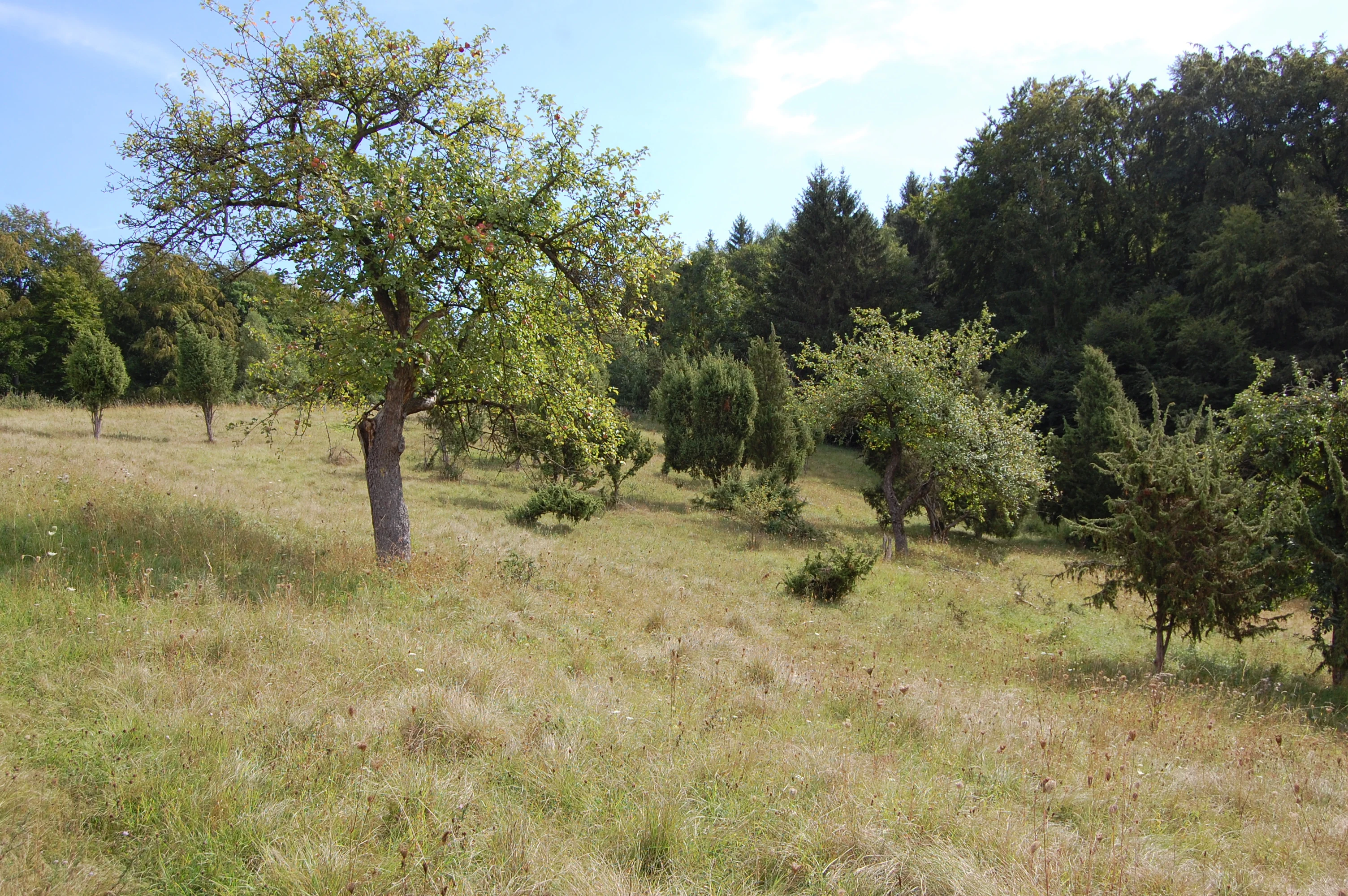
A slightly sloped meadow with scattered deciduous trees and small junipers in the foreground, with a denser forest border in the background.
A view of the open, grassy landscape within the Ostheimer Hute nature reserve, featuring scattered fruit trees and junipers.

Ostheimer Hute history and protected-area timeline

Ostheimer Hute has roots as a traditional village grazing ground. Historically, the term "Hute" described land collectively grazed by a community, with livestock such as sheep and goats looked after by a designated herdsman. The defining pastoral use shaped the open Grassland character of the slopes for centuries.

By the twentieth century this traditional use had lapsed, and the site fell into neglect. For several decades the slopes lay as fallow land, gradually becoming overgrown with shrubs. Juniper, a species largely avoided by grazing animals, expanded across the site, forming the characteristic Wacholderheide, or juniper heath, that is still associated with the reserve today.

Modern conservation management revived the grazing tradition as an explicit stewardship measure. The area was formally protected in 1989 as a Naturschutzgebiet under German nature conservation law. In 2008 it was additionally designated as part of the Natura 2000 network, recognizing its broader European ecological significance. The site is also included in the Magerrasen, Bergwiesen und Heiden biotope connection scheme outlined in the North Hesse landscape framework plan of 2000, which anchors it within the wider Diemeltal conservation landscape.

Ostheimer Hute landscape and geographic character

Ostheimer Hute occupies southwest-facing steep slopes along the lower flanks of the Arensberg, a hill rising above the Diemel valley floor near the village of Ostheim. The terrain is shaped by the underlying Muschelkalk, a Triassic limestone that gives the local scenery both its pale rocky character and its rich base-rich soils.

The reserve is divided into two sections: one lying directly above the village of Ostheim to the east of the Diemel valley, and a longer, narrower section a short distance to the northeast, set against the slope of a small dry valley at the foot of the Arensberg. This open, sunlit setting, with thin soils, stony ground, and exposed rock, defines the dry grassland landscape that gives the reserve its ecological value.

The wider Diemeltal context surrounds these slopes with a varied mosaic of wooded ridges, dry valleys, meadows, and river habitat along the Diemel itself, though Ostheimer Hute itself focuses narrowly on the calcareous slope Grassland aspect rather than the river or forest systems.

Ostheimer Hute ecosystems, habitats, and plant life

The ecological core of Ostheimer Hute is its calcareous dry grassland, an open, sun-exposed habitat developed over hundreds of years of extensive grazing. The vegetation belongs to the Gentiano-Koelerietum community, the historically grazed variant of Kalkmagerrasen, characterized by low-growing herbs, sedges, and grasses adapted to thin, nutrient-poor, calcium-rich soils.

A particularly lean and stony form of this community occurs in parts of the reserve, marked by patches of open ground and the presence of mosses specialized for calcareous substrates. Scattered through the sward are juniper shrubs, the relic of the juniper heath that developed during the site's long period of abandonment.

The result is a habitat mosaic in which open grassland, bare stony patches, and juniper thickets combine to create a wide range of microhabitats. This structural diversity is precisely what supports the reserve's outstanding botanical and invertebrate richness and explains why an area of just over 16 hectares can hold a concentration of species more typical of much larger sites.

Ostheimer Hute wildlife and species highlights

Ostheimer Hute is primarily recognized for its invertebrate fauna, especially the groups favored by warm, open calcareous grasslands. Butterflies are particularly well represented, with species such as Colias alfacariensis, the Berger's clouded yellow, and Hesperia comma, the silver-spotted skipper, both present. These warmth-loving butterflies depend on the open sward and specific larval host plants typical of managed Magerrasen.

Among the more specialized insect groups, the reserve holds rare leafhopper species at the edge of their European range. Goniagnathus brevis and Doratura horvathi reach the northwestern limit of their distribution in this part of the Diemel valley, making Ostheimer Hute a significant outpost for these taxa.

The land snail Helicella itala is common throughout the site, and birds typical of open, shrub-rich habitats also use the reserve. Red-backed shrikes breed here, taking advantage of the combination of rough grassland and scattered juniper for nesting and hunting. Together these groups reinforce the site's role as a small but disproportionately rich wildlife refuge within the broader Diemeltal landscape.

Ostheimer Hute conservation status and protection priorities

Ostheimer Hute's conservation significance lies in its place within one of the foremost concentrations of Kalkmagerrasen in northern Germany. Although the reserve itself is small, it contributes to a regional network of more than 140 calcareous grassland sites covering around 750 hectares across Hesse and North Rhine-Westphalia. This collective scale gives the Diemeltal national importance for conserving habitat types that have become rare across much of central Europe.

The reserve was designated in 1989 as a Naturschutzgebiet under German federal and state nature conservation law, providing strict protection for its biota and land use. In 2008 it was additionally integrated into the Natura 2000 network as a site of European interest, recognizing its contribution to the EU Habitats Directive.

A central element of the conservation approach is the reinstatement of low-intensity grazing, which reverses decades of scrub encroachment and maintains the open structure needed by the specialist grassland flora and fauna. The reserve also fits into the biotope connection scheme Magerrasen, Bergwiesen und Heiden, embedding it in a deliberate landscape-scale strategy for maintaining calcareous grasslands in the Diemeltal and surrounding hills.

Ostheimer Hute cultural meaning and human context

The reserve's name preserves a piece of local agricultural heritage. A Hute in the traditional Hessian sense was a communal grazing ground where livestock, primarily sheep and goats, were watched over by the village shepherd as part of a shared rural economy. This long-running land use created the open, species-rich grasslands that today form the basis of the site's ecological value.

That pastoral identity almost disappeared when the grazing tradition faded and the slopes were abandoned for several decades. Conservation management has consciously revived the old practice, using grazing as a deliberate tool to maintain the reserve's character and to keep the memory of the historical land use alive in practice.

Visitors encountering Ostheimer Hute through the Eco-Pfad Muschelkalk im Diemeltal also walk a trail designed to interpret the wider cultural and geological history of the region, linking the Grassland reserve to the long story of how communities have used the Muschelkalk slopes of the Diemel valley.

Top sights and standout views in Ostheimer Hute

Ostheimer Hute stands out as a textbook example of a small, well-managed calcareous grassland reserve, combining botanical richness, invertebrate diversity, and active cultural landscape stewardship on Muschelkalk slopes. The presence of juniper heath remnants within the restored grassland adds a distinctive visual and ecological character that connects the reserve directly to its pastoral past.

Its dual designation as both a German Nature Reserve and a Natura 2000 site, together with its integration into the Diemeltal biotope connection scheme, makes it a focal point within one of the most significant clusters of calcareous grassland in northern Germany, despite covering just over 16 hectares in total.

Best time to visit Ostheimer Hute

Ostheimer Hute is a low-elevation, open calcareous grassland reserve on warm southwest-facing slopes, so it lends itself most to visits in late spring and summer when the grasses, herbs, and orchids are in bloom and the butterfly fauna is active.

Late spring through early summer is generally the richest period botanically, when many of the orchid populations, gentians, and Linum austriacum flower, while mid to late summer brings warmth-loving butterflies such as Colias alfacariensis and Hesperia comma to the wing. Walking the site in cooler or wetter seasons still offers the scenic value of the open Muschelkalk slopes and juniper shrubs, though the floral and insect highlights are markedly reduced outside the warm months.

Monthly climate preview

Review measured monthly averages and analyze representative coordinates for Landkreis Kassel

Ostheimer Hute Climate Normals: Long Term Temperature and Precipitation Rhythm

Long term climatology data reveals the recorded temperature ranges and precipitation patterns across representative coordinates for Ostheimer Hute. Examining the full monthly sequence provides clear analytical depth regarding annual weather rhythms and long term environmental averages.
Annual mean8 °C
-1 °C18 °C
Jan-1°
Feb
Mar
Apr
May12°
Jun16°
Jul18°
Aug18°
Sep14°
Oct
Nov
Dec
Warmest month
July

18 °C

Coolest month
January

-0.6 °C

Wettest month
July

2.5 mm/day

Driest month
April

1.5 mm/day

Park location guide

Geography guide, regional context, and park location map for Ostheimer Hute

Ostheimer Hute park geography, regions, and map view in Germany

Understand where Ostheimer Hute sits in Germany through a broader geographic reading of the surrounding landscape, nearby location context, and its mapped position within the national park landscape.

How Ostheimer Hute fits into Germany

Germany is a federal republic in Western and Central Europe with a population of over 83 million across sixteen constituent states. It is Europe's largest economy by nominal GDP and a major global exporter and importer. The capital is Berlin, and the country borders Denmark, Poland, Czech Republic, Austria, Switzerland, France, Luxembourg, Belgium, and the Netherlands.

Wider geography shaping Ostheimer Hute in Germany

Germany is located in Western and Central Europe, spanning 357,022 km². It borders Denmark to the north, Poland and the Czech Republic to the east, Austria and Switzerland to the south, and France, Luxembourg, Belgium, and the Netherlands to the west. The country has coastlines on the Baltic Sea and North Sea to the north, with the Alps located in the southern region.

Map view of Ostheimer Hute

Use this park location map to pinpoint Ostheimer Hute in Germany, understand its exact geographic position, and read its mapped placement within the surrounding landscape more clearly.

Pigeon | © OpenStreetMap contributors

Location context for Ostheimer Hute

Landkreis Kassel

Visual reference for calcareous dry grasslands, juniper heath, and Muschelkalk limestone slopes

Ostheimer Hute Photos and Mapped Landscape Scenery in Northern Hesse

Visual records capture the steep southwest-facing limestone slopes and open pasture terrain that define the protected environment of Ostheimer Hute. Examining these habitat photographs reveals the distinctive botanical character and rare orchid distributions shaping the Diemel Valley nature reserve.

A slightly sloped meadow with scattered deciduous trees and small junipers in the foreground, with a denser forest border in the background.

Park atlas

Compare adjacent limestone grasslands and connected regional conservation landscapes

Explore Parks and Protected Areas Near Ostheimer Hute in Northern Germany

Browsing other protected areas near Ostheimer Hute reveals a wider network of species-rich calcareous habitats and limestone slopes. Examining these connected reserves provides essential geographical context for understanding regional conservation patterns across the Diemel Valley.
A soft watercolor painting showing a winding river flowing through a green meadow with rolling hills and distant forested ridges under a pale, warm sky.
Nature reserveLandkreis Kassel
1.5 km away#1 closest

North

Kalkmagerrasen und Diemelaltwasser bei Lamerden Nature Reserve and Landscape Overview

A rare protected mosaic in the Landkreis Kassel district

Investigate the distinctive geography of Kalkmagerrasen und Diemelaltwasser bei Lamerden, where shell limestone slopes rise above the Diemel river oxbow. This protected habitat complex serves as an important ecological anchor in northern Germany, preserving the delicate balance between riparian flood zones and orchid-rich calcareous grasslands that define this regional landscape.

Area
0.175 km²
Established
1989
Relief
Upland
Climate
Temperate
A soft watercolor painting of rolling green and yellow hills under a clear sky, featuring sparse shrubbery and a gentle, layered horizon.
Nature reserveHessen
2.2 km away#2 closest

Southeast

Mittelberg bei Hofgeismar: Nature Reserve and Protected Calcareous Grassland Site

A high-quality conservation landscape located in northern Hessen, Germany.

This nature reserve protects an ecologically rich slope habitat west of Hofgeismar. Defined by its sun-exposed calcareous soil and dry grassland, the site supports ten orchid species and a diverse assemblage of Red List butterflies. It stands as a textbook example of a small, high-density biodiversity hotspot embedded within the broader agricultural geography of the Kassel district.

Area
0.432 km²
Established
1991
Relief
Upland
Climate
Temperate
A soft watercolor illustration showing rolling green hills, distant mountains, and forested slopes on a white background.
Nature reserveHesse
2.6 km away#3 closest

Northeast

Dingel und Eberschützer Klippen: Protected Landscapes and Geography in Hesse, Germany

A dense mosaic of limestone slopes, juniper scrub, and beech forest communities.

Discover the geographic identity of Dingel und Eberschützer Klippen, a combined nature reserve and Natura 2000 site in northern Hesse. The protected area features a unique concentration of orchid-rich habitats, south-facing limestone slopes, and broadleaf forest blocks that define this essential part of the Reinhardswald region.

Area
1.123 km²
Established
1987
Relief
Upland
Climate
Temperate
A soft watercolor illustration showing rolling green hills, small groups of conifer trees, and a pale pink and peach sky in the background.
Natural monumentEberschütz
3 km away#4 closest

North

Der Bunte Berg bei Eberschütz: Natural Monument and Landscape Geography

Limestone ridge and calcareous grassland habitat in Germany

Examine the topography and protected land features of Der Bunte Berg bei Eberschütz. This compact reserve provides a critical study of limestone-influenced terrain, transitioning from mature pine and beech woodland to specialized juniper heath and dry grassland habitats essential for regional biodiversity.

A watercolor painting showing a soft, panoramic view of rolling green hills, lush vegetation, and water, with a light and airy artistic style.
Nature reserveHesse
About 5 km away#5 closest

South

Meßhagen bei Niedermeiser Nature Reserve: Protected Landscape and Regional Geography

A mapped conservation site in the woodlands of Northern Hesse

Meßhagen bei Niedermeiser represents a key nature reserve in Northern Hesse, characterized by its transition between old beech forest and managed calcareous grasslands. This protected area, part of the wider Kelzer Holz network, provides a study in managed habitat succession, where meadow flora and invertebrate populations thrive in the intersection of open terrain and dense woodland edges.

Area
0.546 km²
Established
1996
Relief
Upland
Climate
Temperate
Nature reserveHesse
About 5.8 km away#6 closest

Southeast

Kelzer Teiche Nature Reserve: Mapped Geography and Protected Wetland Boundaries in Hesse

A historic managed fishpond landscape in the Kassel region of northern Germany.

Kelzer Teiche encompasses 18.5 hectares of lowland countryside defined by its twin fishponds and fringe habitats. This nature reserve plays a recognizable role in the regional network of protected sites in Hesse, offering essential shelter for reed dwelling and migratory birds within a broader agricultural setting.

Area
0.185 km²
Established
1977
Water
Major water bodies
A soft watercolor painting of gentle green rolling hills and meadows under a faint pink sky.
Nature reserveHesse
9 km away#7 closest

Northeast

Flohrberg und Ohmsberg bei Deisel Nature Reserve; Calcareous Landscape and Park Boundaries

A protected Hessian site near Trendelburg

Situated in the Landkreis Kassel, Flohrberg und Ohmsberg bei Deisel encompasses 107 hectares of calcareous ground, disused quarries, and sheep-grazed grasslands. The area provides a critical landscape context for orchid-rich flora and rare butterfly fauna within the northern Hessian hill country, acting as a protected link between open farmland and the Reinhardswald forest edge.

Area
0.418 km²
Established
1990
Watercolor painting of a calm wetland landscape with soft green trees along the water edge under a light, misty sky.
Nature reserveHessen
11 km away#8 closest

Southeast

Rothenberg bei Burguffeln Protected Wetland Landscape and Nature Reserve in Hessen

A specialized pond and meadow mosaic in the Hessian lowlands

Rothenberg bei Burguffeln preserves a vital wetland complex near Immenhausen, structured across three distinct sections, including the Rothenküler Teich and Tonkaule. The area represents a significant example of culturally shaped lowland geography, blending historic aquaculture with contemporary habitat management. Its protected status reflects a commitment to maintaining intricate riparian corridors and meadow ecosystems within the wider Hessian countryside.

Area
0.278 km²
Established
1983

Common questions about visiting, size, designation, and location context for Ostheimer Hute

Ostheimer Hute FAQs for park facts, access, geography, and protected area context

Find quick answers about Ostheimer Hute, including protected-area facts, park geography, trail and visitor context, and how the park fits into its surrounding country and regional landscape.
MoriAtlas Explorer

Continue Your Protected Areas Search Across the Global Atlas

Deepen your exploration by continuing the structured search for national parks and protected areas worldwide. Utilize the comprehensive filtering capabilities to compare different conservation landscapes and refine your understanding of global park geography. Discover more about the distribution and characteristics of protected natural areas.

Global natural geography