
Mori Atlas logo
Regional parkParc Ela

Tracing the vertical range, mapped moor landscapes, and cultural heritage of this Alpine region.

Parc Ela: A Comprehensive Geographic Overview of Switzerland's Largest Regional Nature Park

(Regionaler Naturpark von nationaler Bedeutung Parc Ela)

Parc Ela preserves a vast vertical cross-section of the central Swiss Alps, stretching from the deep Schinschlucht gorge to the glaciated summit of Piz Kesch. Within the Canton of Graubünden, this expansive regional park protects diverse habitats ranging from dense mountain forests and nationally significant moor landscapes to the high-alpine terrain of the Albula and Oberhalbstein valleys. Its boundaries encompass a living cultural landscape where centuries-old villages and UNESCO-listed infrastructure integrate with rare ecological refuges.

Alpine landscapesglaciersmoor landscapesmountain forestshedgerow habitatsbiodiversity hotspot
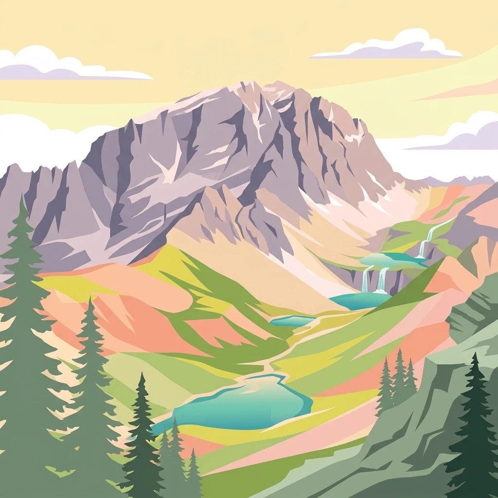
A digital illustration of a jagged mountain peak above a valley with pine trees, small lakes, and waterfalls.

Parc Ela

Regional park

Park overview

Structured park overview, official facts, and landscape profile for Parc Ela

Parc Ela park facts, protected area profile, and essential visitor context

Review the core facts for Parc Ela, including designation, size, terrain, visitor scale, habitats, and operating context in one park-focused overview.

About Parc Ela

Parc Ela is the flagship regional nature park of Graubünden and the largest of its kind in Switzerland. Designated under the federal label of Regionaler Naturpark von nationaler Bedeutung, the park is built around the idea that Alpine cultural landscapes cannot be conserved without sustaining the villages, agriculture, languages, and traditional knowledge that have shaped them. Its territory spans the central part of the canton, covering the Albula and Oberhalbstein valleys and the iconic pass corridor linking northern Europe to the south via the Albula, Julier, and Septimer passes, all in use since the Bronze Age.

The park covers an area of 659 square kilometers, of which roughly 200 square kilometers are undisturbed natural land. Six municipalities participate directly in the park organization, and after a series of municipal mergers the territory has consolidated into entities such as Albula/Alvra, Bergün Filisur, Surses, and Lantsch/Lenz. The geography of the park is unusually compressed: elevations drop to around 745 meters in the Schinschlucht gorge and rise to 3,418 meters at Piz Kesch. This vertical range encompasses the entire spectrum of central Alpine life zones, from floodplain forest and rich hay meadows through subalpine larch and stone pine stands to nival rock and glacier terrain.

Ecologically, Parc Ela is remarkable for the density and variety of its habitats. The Albulatal supports a rare continuous hedgerow network that shelters field hares, smooth snakes, wall lizards, and an exceptionally high diversity of insects. The park claims roughly one-third of all Swiss insect species within its borders, including about 200 threatened taxa. Above the tree line, three nationally protected moor landscapes, Alp Flix, Alp da Stierva, and Val da Sett, host specialized alpine flora and fauna. Four dedicated forest reserves, Val Faller, Crap Alv-Ervedi, Crap Furò, and La Niva, are managed as untouched natural forest. Wildlife is correspondingly rich, with more than seventy mammal species recorded, large populations of ibex, red deer, and chamois, and breeding populations of birds such as bearded vulture, golden eagle, black grouse, and capercaillie. Reptiles including the adder and several amphibians share the lower valleys with a remarkable forty species of wild orchids.

Culturally, Parc Ela is one of the most distinctive protected areas in the Swiss Alps. Ten villages within its boundary have been designated as part of the inventory of Swiss built heritage of national significance, exemplified by hamlets such as Bergün, Filisur, Alvaneu, Brienz/Brinzauls, and Stierva, where the Engadine house style introduced across the Albula Pass is enriched by sgraffito decoration. The Albula and Bernina railway lines of the Rhaetian Railway, both inscribed as UNESCO World Heritage in 2008, sweep through the park, with iconic structures including the 65-meter Landwasser Viaduct and the towering 90-meter Wiesener Viaduct. Add to this the church of St. Peter Mistail, a Carolingian structure dating to around the year 800, and the pilgrimage church of Ziteil above Muntogn, and the cultural depth of the park becomes apparent.

The park is also a paleontological site of world rank. On the summits of Piz Ela, Tinzenhorn, and Piz Mitgel, fossilized dinosaur footprints from roughly 200 million years ago have been preserved. The tracks on the summit of Piz Ela are both the highest in elevation and among the oldest in the world. While access is restricted to experienced mountaineers, the discovery underlines the geological antiquity of the terrain now protected as Parc Ela. Combined with more than 1,000 kilometers of marked hiking trails, the long-distance Parc Ela Trek, and the national Alpenpässe-Weg route 6, the park offers a layered experience that connects present-day rural life, deep Earth history, and the very particular linguistic and architectural heritage of Middle Bünden.

Quick facts and research context for Parc Ela

Parc Ela is Switzerland's largest regional nature park and lies in central Graubünden across the Albula and Oberhalbstein valleys. Established as a candidate park in 2008 and officially labeled by the Swiss federal government on 23 June 2012, it now encompasses 659 square kilometers, of which approximately 200 square kilometers are considered untouched natural area. Six municipalities belong to the park: Albula/Alvra, Bergün Filisur, Lantsch/Lenz, Schmitten, Surses, and the Wiesen fraction of Davos.

The park covers an elevation range from about 745 meters in the Schinschlucht gorge to 3,418 meters at the Piz Kesch, and includes glacial and periglacial zones as well as three moor landscapes of national significance. Parc Ela is a multilingual region where German, Romansh (Surmiran), and Italian are spoken, and the Romansh language is actively promoted as part of the park's cultural mandate. The territory contains ten villages listed in Switzerland's inventory of nationally significant built heritage, and portions of the Albula and Bernina railway lines, both UNESCO World Heritage Sites, run through the park.

Protection and recognition

Documented management scope and official establishment records established in 2012.

Parc Ela Protection Status and Designated Terrestrial Conservation History

Terrestrial conservation records for Parc Ela outline documented protection status and establishment history dating to 2012. Structured facts provide clear reference metrics regarding management scope and designated territorial frameworks.

Protection details

Protection scope
Terrestrial
Designated year
2012
Transboundary protection
No
Park context

Deeper park guide and search-rich context for Parc Ela

Parc Ela history, landscape, wildlife, and travel context

Explore Parc Ela through its history, landscape character, ecosystems, wildlife, conservation priorities, cultural context, and seasonal travel timing in a structured park guide built for atlas discovery and search intent.

Why Parc Ela stands out

Parc Ela is best known for the breadth of intact Alpine habitats it protects across a full vertical range, from deep gorge forests up to active glaciated peaks. Its moor landscapes, particularly the Alp Flix, Alp da Stierva, and Val da Sett, are classified nationally for their ecological value, and the park's hedgerow network in the Albulatal supports one of the richest insect faunas in Switzerland, including many threatened species. Large mammal populations thrive here as well, with substantial stocks of Alpine ibex, around three thousand red deer, and chamois joined by charismatic raptors such as bearded vultures and golden eagles. Equally defining is the park's intertwined natural and cultural heritage. Its ten villages of national significance, the UNESCO-listed Albula railway, and the unusually well preserved dinosaur trackways on the summit of Piz Ela together create a landscape where geological time, Alpine biodiversity, and centuries of Romansh and German-speaking Alpine culture converge. Few Swiss parks combine paleontological, linguistic, architectural, and high-mountain ecological significance in this way.
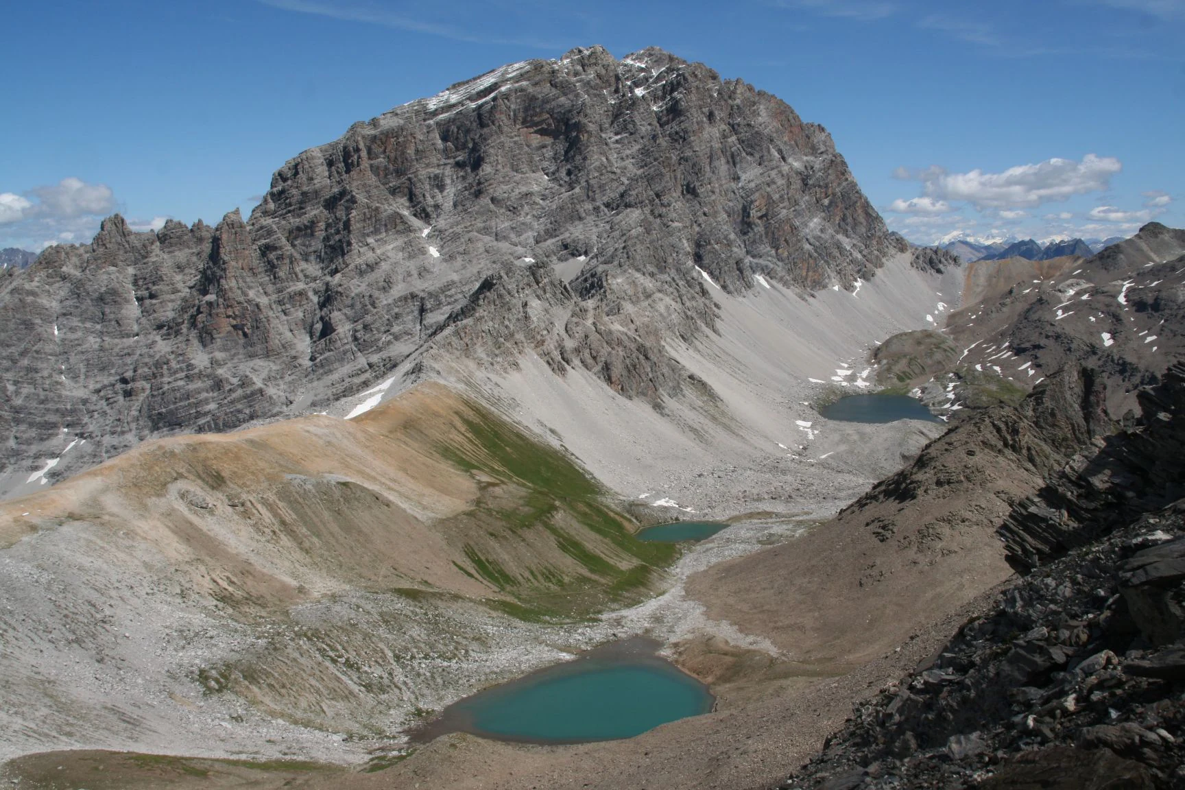
A wide, high-angle mountain view showing the craggy, grey limestone peak of Piz Ela in the center, with small turquoise glacial lakes and scree slopes visible in the foreground and midground.
The prominent summit of Piz Ela towering above the glacial lakes of the Parc Ela landscape.

Parc Ela history and protected-area timeline

The history of Parc Ela as an organized nature park began in the middle of the 2000s, after years of regional discussion about how to protect the cultural and natural landscapes of central Graubünden. On 31 May 2005, the Parc Ela association was founded as the legal carrier of the future park, with private individuals and the municipalities of the planned territory as members. A four-year trial phase was launched, during which the association focused on raising public awareness in its first operational year and then on initial projects and events. The population of 21 municipalities at the time voted in favor of pursuing a park candidacy.

In late summer 2008, the Swiss federal government accepted Parc Ela as an official candidate for a regional nature park and approved financial support for the trial phase through the end of 2011. The municipalities agreed to participate, and projects were funded across three thematic areas: economic development, nature and cultural landscape conservation, and environmental education. In autumn 2010, voters in the park municipalities once again went to the polls; nineteen of the twenty-one municipalities decided to remain within the park project, while Riom-Parsonz and Tinizong-Rona opted out, citing fears of regulatory restrictions. In June 2012, the federal government awarded Parc Ela the label Regionaler Naturpark von nationaler Bedeutung, valid for an initial ten-year operating phase.

Since then the park has continued to evolve alongside municipal restructuring in Graubünden. Through a series of mergers the original 21 municipalities have consolidated into six, and in the process the formerly excluded territories of Riom-Parsonz and Tinizong-Rona are now part of the park through their inclusion in the enlarged municipality of Surses. Between late 2020 and early 2021, all six park municipalities confirmed their continued commitment to the park, and the association approved both the new park contract and the management plan for the second operating phase covering 2022 to 2031. In July 2021 the Federal Office for the Environment approved the application and re-awarded the park label for another ten years.

Parc Ela landscape and geographic character

The landscape of Parc Ela is a textbook vertical cross-section of the central Swiss Alps. In the lower reaches, the Albula and Oberhalbstein valleys descend through forested gorges; the lowest point of the park lies at about 745 meters in the Schinschlucht, where water has carved a narrow passage through dark rock. Above this, hay meadows, scattered hamlets, and the famous Albulatal hedgerows occupy the valley floor, before the slopes rise into dense coniferous and mixed mountain forest. In the side valleys such as Val Faller near Mulegns, old-growth larch stands mixed with spruce and stone pine, an increasingly rare sight in the Alps.

The middle elevations of the park are characterized by open Alpine pasture, larch fields, and the beginnings of higher moor and rock scenery. The Alp Flix, a high plateau above Sur, the Alp da Stierva, and Val da Sett are among the most prominent high-elevation features, each designated as a moor landscape of national significance. These flat or gently sloping basins capture water, support specialized bog flora, and offer wide views across the surrounding peaks.

Above the tree line, the terrain enters classic high-Alpine territory. Rock, scree, and persistent snowfields dominate the skyline of the park, and small remaining glaciers still cling to massifs such as Piz Kesch, Piz d'Err, and Piz Platta. The Kesch-Ducan area near Bergün Filisur is officially recognized as a landscape of national significance, with the Porchabella glacier and its ever-shifting forefield forming one of the most striking high-mountain scenes in the park. The highest point of the park, the 3,418-meter summit of Piz Kesch, anchors this high country and gives the park an almost unmatched vertical range within so compact a territory.

Parc Ela ecosystems, habitats, and plant life

The natural character of Parc Ela rests on the exceptional diversity of habitats packed into a relatively small area. Lower-elevation valley bottoms feature traditional Alpine hay meadows threaded with hedgerows, a habitat combination that has become extremely rare in central Europe. Deep gorges such as the Schinschlucht support relict forest communities adapted to shade, humidity, and steep relief. Higher up, subalpine larch and stone pine forests give way to alpine meadows, then to the three nationally significant moor landscapes of Alp Flix, Alp da Stierva, and Val da Sett, each offering specialized flora and fauna.

Park policy reflects the value placed on these habitats. Beyond the system of national moor protections, the park manages four dedicated forest reserves, Val Faller, Crap Alv-Ervedi, Crap Furò, and La Niva, in which forests are deliberately left to develop without forestry intervention. The glaciated zones of the Kesch-Ducan and Piz d'Err regions, while under pressure from climate-driven retreat, still define the highest and most geologically active sectors of the park. Across these zones, the overarching ecological story is one of intact connectivity: high Alpine specialists, mid-elevation ungulates, and lowland hedgerow species all share the same continuous landscape.

Parc Ela wildlife and species highlights

Wildlife in Parc Ela is unusually rich because the park offers effective ecological connectivity across elevation zones. Large mammals are a defining presence, with more than seventy species recorded. Substantial populations of Alpine ibex inhabit the rocky upper slopes, while red deer number around three thousand individuals across the forested valleys and Alpine pastures, alongside more widely distributed chamois and roe deer. Smaller mammals such as the field hare thrive especially in the hedgerow mosaic of the Albulatal.

Birdlife is sweeping and includes both resident and breeding visitors. Raptors are a notable signature of the park's skies, with bearded vultures, golden eagles, black kites, and several falcon species recorded. Among grouse, both capercaillie and black grouse still maintain populations in the larch and mixed forests of the upper valleys, while lower elevations and meadows support characteristic songbirds such as whinchats, robins, tits, and finches.

Lower-elevation fauna is also remarkable. The park's reptile list includes the adder and several further species, and amphibians are present in four species. The most striking statistic, however, concerns invertebrates. Roughly one-third of all Swiss insect species have been recorded within Parc Ela, including around 200 threatened taxa. About 135 of Switzerland's approximately 240 butterfly species are present, alongside roughly fifty species of wild bees and an effectively uncounted diversity of beetles, making the park one of the most important insect strongholds in the Alps.

Parc Ela conservation status and protection priorities

The conservation significance of Parc Ela lies in the scale and continuity of the habitats it consolidates into a single protected territory. By linking moor landscapes of national significance, dedicated forest reserves, hedgerow mosaics, glacial forefields, and large tracts of intact mountain forest under one management framework, the park achieves a level of habitat connectivity that few Swiss protected areas can match. The insect fauna alone, encompassing roughly one-third of the country's species, positions Parc Ela as a national-scale refuge for invertebrate diversity.

The park's conservation approach is explicitly regional and socio-ecological. Rather than fencing off nature from people, the park works through its member municipalities and the Parc Ela association to maintain traditional land use, sustain local agriculture, and protect the cultural landscapes that underpin biodiversity. Efforts include the protection of the Romansh language, support for local producers and hosts, and the development of low-impact nature tourism. Through its second ten-year operating phase, the park continues to balance active biodiversity protection, sustainable regional development, and environmental education under the federal Regional Nature Park of National Significance label.

Parc Ela cultural meaning and human context

Cultural identity is integral to what Parc Ela protects. Middle Bünden has long been a meeting point of language communities, and within the park three official languages coexist: German, Romansh in the Surmiran idiom, and Italian. About a third of residents speak Romansh, and the park treats the maintenance and revitalization of this language as an explicit conservation task, alongside the protection of biological diversity.

The architectural heritage of the park is equally distinctive. Ten villages have been designated as part of the federal inventory of Swiss built heritage of national significance, including Alvaneu, Alvaschein, Bergün, Brienz/Brinzauls, Filisur, Latsch, Riom, Salouf, Stierva, and Stugl. Across the Albula Pass, the Engadine house style with its sgraffito decoration has been adopted into local building tradition, producing a distinctive architectural hybrid. Religious buildings add further depth, among them the early medieval church of St. Peter Mistail, an example of Carolingian architecture, and the pilgrimage church of Ziteil, set high above Muntogn. Engineering heritage of international standing is provided by the Albula and Bernina lines of the Rhaetian Railway, a UNESCO World Heritage Site that traverses the park.

Top sights and standout views in Parc Ela

Parc Ela's greatest single highlight is the sheer vertical reach of its protected landscapes, from the 745-meter Schinschlucht gorge to the 3,418-meter summit of Piz Kesch, a span that captures virtually every central Alpine habitat type within one boundary. Equally distinctive is the combination of the UNESCO-listed Albula railway with the network of ten villages of national significance, where world-class engineering sits alongside centuries-old sgraffito-decorated Engadine houses and Romanesque churches. The paleontological record is a third highlight, with 200-million-year-old dinosaur tracks on the summit of Piz Ela representing both the highest and among the oldest such traces in the world. With its three nationally protected moor landscapes, four dedicated forest reserves, and a nationally important raptor and ungulate fauna, the park rewards travelers interested in the full spectrum of Alpine natural and cultural heritage.

Best time to visit Parc Ela

Parc Ela is broadly rewarding across the warmer half of the year when snow has retreated from valley trails and high passes alike. Summer brings accessible high-mountain terrain, flowering alpine meadows, and the most reliable conditions for long-distance routes such as the Parc Ela Trek, the Via Sett, and stretches of the national Alpenpässe-Weg. Early autumn often features calm weather, mature berry crops in the moor landscapes, and the most vivid contrasts between larch forests and bare rock. Late autumn and spring see the lower villages and historic churches at their quietest, and although deep winter closes many of the high routes, valley-level cultural exploration remains possible throughout the year.

Monthly climate preview

Long-term representative point measurements across twelve monthly cycles

Parc Ela Climate Normals, Annual Temperature and Precipitation Patterns

Measured coordinates within Parc Ela record consistent annual shifts in temperature and monthly precipitation norms based on historical data. Examining the complete twelve-month record clarifies monthly variations across the protected terrain.
Annual mean0 °C
-10 °C11 °C
Jan-10°
Feb-10°
Mar-6°
Apr-1°
May
Jun
Jul11°
Aug10°
Sep
Oct
Nov-4°
Dec-9°
Warmest month
July

10.6 °C

Coolest month
January

-10.1 °C

Wettest month
June

4.4 mm/day

Driest month
February

1.5 mm/day

Park location guide

Geography guide, regional context, and park location map for Parc Ela

Parc Ela park geography, regions, and map view in Switzerland

Understand where Parc Ela sits in Switzerland through a broader geographic reading of the surrounding landscape, nearby location context, and its mapped position within the national park landscape.

How Parc Ela fits into Switzerland

Switzerland is a landlocked federal republic in Central Europe comprising 26 cantons, with Bern as the federal city and Zurich as the largest city. The country features the Swiss Alps, Swiss Plateau, and Jura Mountains, with German, French, Italian, and Romansh as official languages. It is noted for its political neutrality, direct democracy traditions, and strong economy.

Wider geography shaping Parc Ela in Switzerland

Switzerland is located in Central Europe at the intersection of Western and Southern Europe. It is bordered by Germany to the north, France to the west, Austria and Liechtenstein to the east, and Italy to the south. The country is geographically divided among the Swiss Alps (covering most of the territory), the Swiss Plateau (where most of the population resides), and the Jura Mountains. Switzerland is landlocked.

Map view of Parc Ela

Use this park location map to pinpoint Parc Ela in Switzerland, understand its exact geographic position, and read its mapped placement within the surrounding landscape more clearly.

Pigeon | © OpenStreetMap contributors

Location context for Parc Ela

Canton of Graubünden

Explore high-altitude terrain, glacial peaks, and rare valley habitats through comprehensive photography.

Visualizing Parc Ela Photos, Scenery, and Protected Alpine Landscapes

Examine detailed photographs of Parc Ela to understand its complete vertical range, from deep forested gorges up to glaciated summits. Visual documentation reveals the distinct character of high moor plateaus, traditional architecture, and diverse protected habitats.

A wide, high-angle mountain view showing the craggy, grey limestone peak of Piz Ela in the center, with small turquoise glacial lakes and scree slopes visible in the foreground and midground.

Park atlas

Discover adjacent Alpine nature reserves and connected high mountain habitats across central Graubünden

Exploring Parks Near Parc Ela and Comparing Regional Protected Landscapes

Visitors comparing Parc Ela can browse nearby protected areas and adjacent Alpine nature reserves across the surrounding region. Examining connected mountain terrain provides deeper geographic context for Swiss conservation landscapes.
Regional parkGraubünden
About 15 km away#1 closest

West

Naturpark Beverin: Exploring Alpine Gorges and Cultural Landscapes in Graubünden

A regional nature park shaped by high alpine ridges and ancient settlement traditions.

Naturpark Beverin encompasses a vast, multi-layered environment in the Swiss Alps. The area is defined by the sharp vertical contrast between carved river gorges like the Viamala and high-elevation ridges. Beyond the rugged mountain terrain, this protected landscape preserves centuries of pastoral history through the distinct settlement traditions of its Romanesque and Walser valleys.

Area
515 km²
Established
2013
Relief
Mountain
Climate
Alpine
A soft watercolor painting of a river winding through a valley with green trees, grassy plains, and distant purple hills against a white background.
Nature reserveGraubünden
About 17 km away#2 closest

East

Naturschutzgebiet Isla Glischa-Arvins-Seglias Nature Reserve in Graubünden

Mapped alluvial terrain and alpine river geography

Situated in the broad valley floor of the Upper Engadin, this nature reserve protects one of the most significant alpine floodplain zones in the Swiss canton of Graubünden. The area features a complex network of river channels, gravel lakes, and marshes that are currently undergoing active revitalization to restore natural riverine processes and support rare riparian ecosystems.

Area
0.867 km²
Established
1992
IUCN
IV
Relief
Upland
National parkGraubünden
About 26 km away#3 closest

East

Swiss National Park: Geographic Context and Protected Alpine Wilderness in Graubünden

A comprehensive look at the Engadin valley's premier wilderness sanctuary

Spanning over 170 square kilometers in the canton of Graubünden, the Swiss National Park offers an unparalleled example of a strictly protected Alpine ecosystem. This atlas profile details the park's distinct topography, from the subalpine pine forests near the Ofenpass to the delicate karst lake basins at Macun, providing a deep look into its history as a central reference site for wilderness restoration and geological research.

Area
170.3 km²
Established
1914
IUCN
Ia
Relief
Mountain
A horizontal watercolor illustration showing stylized, overlapping mountain ridges in shades of soft green, pink, and yellow against a white background.
Natural monumentGraubünden
About 27 km away#4 closest

Southeast

Roseggletscher Natural Monument: Alpine Glacier Geography and Proglacial Lake Mapping

Protected landscape data for the Bernina range in Graubünden.

Examine the geographic boundaries and terrain of the Roseggletscher, a protected natural monument situated in the upper Val Roseg. This record captures its glacial extent, the emergence of the Lej da Vadret proglacial lake, and its role within the wider Bernina glacier ensemble of southeastern Switzerland.

Area
6.38 km²
Relief
Mountain
Climate
Alpine
Access
Moderate access
Watercolor painting of a mountain range with a lake, green hills, and a sunset sky
National parkTrentino-Alto Adige/Südtirol
About 30 km away#5 closest

East

Stelvio National Park National Park: Protected Landscape and Regional Geographic Context

Explore its mapped boundaries and natural terrain.

Navigate Stelvio National Park, a designated national park in Italy's Trentino-Alto Adige/Südtirol region, through a map-centric lens. This page provides critical context for understanding the park's protected landscape, its geographic position within the Alps, and its mapped terrain. Utilize MoriAtlas to grasp the park's boundaries and its place in regional geography for structured natural landscape discovery.

Established
1935
IUCN
II
Relief
Mountain
Scope
Terrestrial
A soft watercolor painting depicting a wide river flowing through a green floodplain with distant mountains in the background.
Nature reserveGraubünden
About 31 km away#6 closest

Northwest

Naturschutzgebiet Rhäzünser Rheinauen: Protected River Landscape and Floodplain Geography

Graubünden Alpine floodplain and alluvial river system

Located in the Swiss canton of Graubünden, Naturschutzgebiet Rhäzünser Rheinauen encompasses 157 hectares of rare, free-flowing river landscape. This protected area supports a diverse succession of plant communities, ranging from pioneer species on shifting gravel bars to mature softwood and hardwood floodplain forests, framed by the dramatic mountain terrain of the Hinterrhein valley.

Area
1.569 km²
Established
1992
IUCN
IV
Relief
Mountain
A soft watercolor painting showing a wide, high-altitude alpine plateau with rolling hills, scattered small lakes, and distant mountain ridgelines.
Nature reserveGraubünden
About 36 km away#7 closest

Northeast

Macun-Seen Nature Reserve: Protected Alpine Plateau and Cirque Lake Landscape

High-altitude basin and crystalline geological features in Graubünden

Located in the Lower Engadine region of Graubünden, the Macun-Seen nature reserve is a significant high-altitude basin formed by glacial action. This protected exclave contains 23 small cirque lakes across a silicate plateau, offering a distinct ecological profile and expansive views of peaks approaching 3000 metres. It stands as a prime example of preserved alpine terrain within the broader Swiss National Park context.

Area
3.6 km²
Established
2000
Relief
Mountain
Climate
Alpine
Nature reserveLombardia
About 38 km away#8 closest

South

Val di Mello Nature Reserve: Mapping the Granitic Geography of the Italian Alps in Lombardia

A study of protected vertical relief, glacial cirques, and Alpine terrain.

Val di Mello offers a profound look at high-altitude Alpine geography, characterized by its immense, light-colored granitic walls and deeply carved tributary valleys. This protected nature reserve acts as a gateway to the broader mountainous terrain of the Lombardia region, showcasing the geological evolution of the Italian Alps through its steep gullies, high summits, and expansive valley floor.

Established
2009
Relief
Mountain
Access
Moderate access
Scope
Terrestrial

Common questions about visiting, size, designation, and location context for Parc Ela

Parc Ela FAQs for park facts, access, geography, and protected area context

Find quick answers about Parc Ela, including protected-area facts, park geography, trail and visitor context, and how the park fits into its surrounding country and regional landscape.
MoriAtlas Explorer

Continue Your Protected Areas Search Across the Global Atlas

Deepen your exploration by continuing the structured search for national parks and protected areas worldwide. Utilize the comprehensive filtering capabilities to compare different conservation landscapes and refine your understanding of global park geography. Discover more about the distribution and characteristics of protected natural areas.

Global natural geography