
Why Rhäzünser Rheinauen stands out
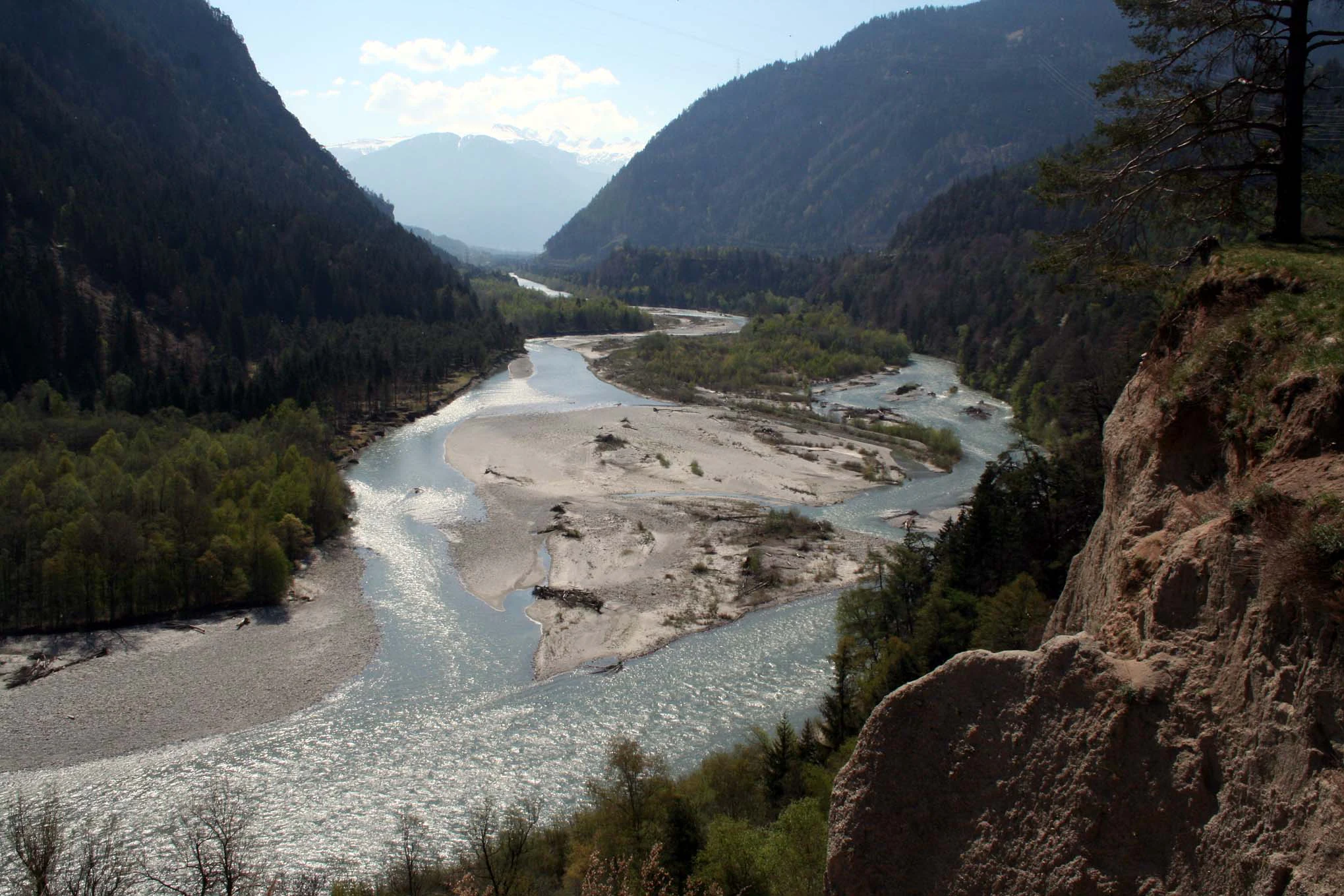
The reserve is best known for its exceptional Alpine floodplain character: a six-kilometer stretch of the Hinterrhein that still meanders and braids freely through a deep valley between the Feldis/Veulden massif and the Rhäzüns plateau, with shifting gravel banks, wooded islands, and the broad gravel floodplain locally called Isla Bella. It is also recognized as one of the most botanically rich floodplain sites in the canton, with more than a thousand recorded plant species ranging from pioneer herbs on freshly deposited gravel to mature Grey alder and hardwood floodplain forest.
Rhäzünser Rheinauen history and protected-area timeline
The broader cultural landscape around the Rhine floodplain has been listed in Switzerland's federal inventory of landscapes and natural monuments of national importance since 1977, recognizing the scenic and ecological coherence of the lower Hinterrhein valley. The floodplain itself received its specific national designation as an Auengebiet von nationaler Bedeutung in 1992, under the federal ordinance protecting nationally important floodplain areas.
A defining chapter in the reserve's modern history came in the late 1960s and 1970s, when the planned route of the new A13 motorway between Chur and the Domleschg was originally drawn directly through the Rhäzüns floodplain. Local residents, the Talschaft Heinzenberg-Domleschg, and environmental organizations, including Pro Natura Graubünden, pushed for a more landscape-compatible alternative. After renewed studies and an on-site inspection with federal representatives in 1974, the motorway was rerouted through two tunnels with only a single bridge crossing the protected floodplain, preserving the integrity of what would soon become a nationally designated reserve.
In more recent decades, the area has faced new pressures from hydropower operations upstream, which generate strong daily flow fluctuations known as Schwall und Sunk along this stretch of the river. These fluctuations repeatedly threaten fish spawning and juvenile survival, and the canton of Graubünden has been working on plans to revitalize the riverbed between Rothenbrunnen and Rhäzüns. Discussions in 2023 explored whether even the protected floodplain's river gradient might be tapped for additional energy production, raising ongoing questions about how to balance ecological protection, energy use, and landscape character.
Rhäzünser Rheinauen landscape and geographic character
The protected landscape centers on a six-kilometer stretch of the lower Hinterrhein that runs through a deep, narrow incision in the old glacial valley floor. North of the broad Domleschg, where the river was straightened in the nineteenth century, the Hinterrhein here regains a natural, dynamic form, descending roughly fifteen meters in altitude across the floodplain, which sits at an average elevation of about 605 meters above sea level. The valley walls rise on either side to the Feldis/Veulden massif at around 1469 meters to the east and to the Rhäzüns plateau near 657 meters and Bonaduz at 658 meters to the west, giving the floodplain an enclosed, mountain-flanked character.
The valley itself was shaped by ice-age glaciation and then by the catastrophic Tamins rockfall around 13,000 years ago, which dammed the Rhine and created a temporary lake near Reichenau. Sediments from the Vorderrheintal filled this basin, producing the broad alluvial fan on which Rhäzüns and Bonaduz now stand. After the river eventually broke through the rockfall barrier, it cut down into the older valley floor, producing the inset, meandering floodplain of today. The current drainage area still delivers an average flow of roughly 59.6 cubic meters per second at the lower end of the Hinterrhein, with strong seasonal and event-driven variation due to the High Alpine catchment, and regular flood events continue to rework gravel bars, channels, and islands.
Within the floodplain, the Romansh-speaking local communities distinguish the dry, flat areas between branched channels as Isla, with the widest section of multiple gravel islands known as Isla Bella, meaning beautiful island. The surrounding terrain is studded with named landforms, including the Undrau ridge, the high and low Tarmuz boundary stones, the castle hill above Rhäzüns, the Darnaus rock spur, the Bot da Sogn Gieri hill crowned by an early Romanesque church at 689 meters, the Plazzas rock block with its floodplain forest, and the Bot Panadisch at 649 meters. On the opposite side, the ruins of Hochjuvalt castle stand on a high rocky outcrop above the locality of Ravetsch, anchoring the gorge-like northern margin of the protected floodplain.
Rhäzünser Rheinauen ecosystems, habitats, and plant life
Ecologically, Rhäzünser Rheinauen is a textbook Alpine floodplain, where the shifting mosaic of open gravel, pioneer vegetation, softwood forest, hardwood floodplain stands, and dry slopes creates habitats that change with each flood event. More than a thousand plant species are recorded across this gradient. Freshly deposited gravel and sand banks host pioneer herbs and, unusually for the altitude, plants swept down from Alpine source areas, along with willow scrub. Areas a little farther from the active channel support Grey alder forest with a variety of shrubs, while the rarely flooded hardwood floodplain stands contain ash, elm, maple, spruce, and oak. On drier ground, including the broken terrain of the former rockfall mass, Scots pine woodland has established.
The reserve also encompasses ecologically important wetland pockets. The Plazzas floodplain forest with its associated wetland is independently designated as an amphibian breeding area of national importance. The floodplain is well-connected to the surrounding forested hillsides, allowing species to move between the open river system and the wooded slopes, and the beaver has recently recolonized the Hinterrhein, adding a new keystone presence to the river ecosystem.
The floodplain's ecological value also extends beneath the water surface. The lower Hinterrhein supports a community of cold-water fish, including brown trout, lake trout, rainbow trout, lake char, brook char, minnow, and bullhead. Of particular conservation interest is the Bodensee lake trout, which migrates annually from Lake Constance upstream to spawn in the gravel beds of the Rhäzüns and Bonaduz floodplain, although this life cycle remains vulnerable to the strong artificial flow fluctuations caused by upstream hydropower operations.
Rhäzünser Rheinauen wildlife and species highlights
The floodplain supports a notably rich invertebrate fauna typical of dynamic Alpine river systems, with abundant spiders, butterflies, dragonflies, caddisflies and mayflies, bees, ground beetles, ants, and grasshoppers occupying different microhabitats across the gravel bars, channel margins, and forest patches. In the designated amphibian breeding wetland at Bregl, Alpine newt, common toad, and common frog have been documented, and five reptile species are present in the broader area. Up to eighty bird species use the floodplain, including ground-nesting specialists such as the little ringed plover and the common sandpiper, which depend on the open gravel banks. In the evenings, the lesser horseshoe bat hunts insects along the river corridor.
Among mammals, the most significant recent development is the natural return of the beaver to the Hinterrhein, which signals improving ecological conditions in the river system. The reserve also supports a wider community of mammals that move between the floodplain and the surrounding wooded hills. The river itself, beyond its ecological role, is important for migratory fish such as the Bodensee-Seeforelle, which travels from Lake Constance each year to spawn on the floodplain's gravels, linking this Alpine floodplain ecologically with the larger Rhine and lake system downstream.
Rhäzünser Rheinauen conservation status and protection priorities
Rhäzünser Rheinauen is a nationally recognized conservation site in two complementary frameworks. The floodplain itself has been listed as an Auengebiet von nationaler Bedeutung since 1992, with protection anchored in the federal ordinance on nationally important floodplain areas, while the surrounding cultural landscape has been listed under the federal inventory of landscapes and natural monuments of national importance since 1977. The protected area is also formally recorded in the World Database on Protected Areas under entry 148646, and is managed as a habitat and species management area under IUCN category IV.
The core conservation objectives focus on maintaining the largely natural floodplain, including the meandering and braided river system and its broad flood-prone zone, preserving the landforms that give the area its distinct scenic character, and sustaining the quality and ecological function of the river and floodplain habitats together with their characteristic plant and animal communities. Beyond its purely natural elements, the designation explicitly extends protection to the broader landscape pattern of hills, meadows, settlements, and historic structures that together form the visual and ecological setting of the river.
The reserve also faces ongoing conservation challenges. The floodplain lies within a stretch of the Hinterrhein strongly affected by daily hydropeaking from large upstream power stations, which repeatedly stresses fish spawning, juvenile fish survival, and the floodplain's natural flow regime. The Plazzas floodplain forest with its wetland is independently protected as an amphibian breeding area of national importance, highlighting how several overlapping national inventories reinforce each other here. The canton of Graubünden is planning revitalization of the riverbed between Rothenbrunnen and Rhäzüns, and recent debates over additional energy development, including a major 380-kV transmission line crossing the floodplain, illustrate the continuing tension between ecological protection, energy infrastructure, and landscape preservation.
Rhäzünser Rheinauen cultural meaning and human context
The floodplain sits within a region of strong linguistic and cultural heritage. Historically, this part of the Hinterrhein valley marked the boundary between the Alemannic German and Romansh-speaking areas of Graubünden; today Swiss German dominates as the everyday language, but a rich stock of Romansh place names continues to shape landscape identity, including local terms such as Isla for the dry flats between braided channels, Isla Bella for the wide multi-channel island zone, and Gravas as the Romansh collective term for the riverine floodplain itself. Many of the named landforms within and around the protected area, from Tarmuz Ault to Bot da Sogn Gieri, reflect this Romansh substrate.
Cultural landmarks are tightly interwoven with the natural landscape. On a high rock outcrop above the locality of Ravetsch stands the ruined castle of Hochjuvalt, overlooking the floodplain, while on the opposite side the castle hill above Rhäzüns carries the historic Schloss Rhäzüns. The early Romanesque church of Sogn Gieri crowns the Bot da Sogn Gieri hill at about 689 meters above sea level, anchoring the visual character of the valley. The villages of Rhäzüns, Bonaduz, Rothenbrunnen, and Domat/Ems, with their mix of historic buildings, meadows, field strips, and managed woodland, extend the cultural landscape almost to the riverbank, and footpaths and forest roads connect the protected area to this inhabited setting. The successful 1970s campaign to reroute the A13 motorway through tunnels rather than across the floodplain marked an important moment in which the local community and environmental organizations helped embed the area's natural and cultural value into national infrastructure decisions.
Top sights and standout views in Rhäzünser Rheinauen
Among the standout features of Rhäzünser Rheinauen are the six kilometers of free-flowing, meandering and braided Hinterrhein that still shape their own valley floor; the broad gravel island complex known as Isla Bella; the rare transitions from pioneer gravel vegetation to Grey alder softwood forest and then to hardwood floodplain stands on successively older terraces; the more than a thousand plant species recorded across this small area; and the protected amphibian breeding wetland at Plazzas, which adds an additional national designation within the broader reserve.
The floodplain's significance also lies in the way it links ecological processes, cultural landscape, and infrastructure history. The same stretch of river that hosts Bodensee lake trout spawning grounds, returning beavers, and nesting little ringed plovers is framed by the ruin of Hochjuvalt, the early Romanesque church of Sogn Gieri, and the villages of Rhäzüns and Bonaduz, while the A13 motorway passes overhead through tunnels, the result of a 1970s protection campaign that helped preserve the site's integrity long before its 1992 federal designation.
Best time to visit Rhäzünser Rheinauen
Although the reserve has no formal seasonal access restrictions, the late spring, summer, and early autumn months typically offer the most rewarding experience, when the gravel banks are accessible on foot, forest trails are dry, and a wide range of plant and insect communities is active along the channels and floodplain forests. Spring snowmelt and heavy summer rainfall can produce high water on the Hinterrhein, temporarily reshaping the gravel bars and islands while also making parts of the floodplain less accessible, so quieter base-flow conditions often make for easier walking between the historic villages and the river.