Peaks
Hen Cloud
410 m

Regional distribution, terrain characteristics, and mapped natural environment dimensions.
Review the geographic framework of the Peak District, covering 1440 square kilometers of protected landscape across the United Kingdom. This profile details the park boundary, elevation reaching 636 meters, and recorded features including riverine systems, ridges, and complex karst formations. Explore the spatial distribution and environmental classification of this mountain-defined region.
Related tags
About Peak District
The Peak District is an upland area in central-northern England, forming the southern extremity of the Pennines. It was designated as Britain's first national park on 17 April 1951 and remains one of the most visited national parks in the country, welcoming over 13 million visitors annually. The park spans approximately 555 square miles, with most of its area in Derbyshire but extending into Cheshire, Greater Manchester, Staffordshire, South Yorkshire and West Yorkshire. The landscape is classically divided into two distinct areas. The Dark Peak occupies the northern, eastern and western margins, characterized by moorland dominated by gritstone and extensive peat bogs. The White Peak covers the central and southern portions, where limestone geology has created a landscape of valleys, gorges and characteristic white rock outcrops. The highest point is Kinder Scout at 636 metres above sea level. The park's proximity to major urban centres including Manchester, Sheffield, Derby and Stoke-on-Trent makes it an accessible natural retreat for millions of people.
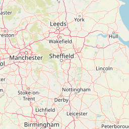
Regional distribution and inland status within the United Kingdom
Interactive boundary geometry and calculated geographic area metrics.
A 636-metre maximum with twenty records displayed within
Peaks
410 m
Peaks
489 m
Peaks
287 m
Cave entrances
Peaks
559 m
Natural springs
374.1 m
Recorded relief, habitat types, and climate zone parameters across the terrain
Mountains · Hills · Valleys · Plateau · Cliffs · Canyon · Forest · Woodland · Grassland · Wetland · Lakes · Rivers · Cave · Karst
Wetland · Peatland · Grassland · Temperate broadleaf forest · Temperate coniferous forest · Riverine habitat · Lacustrine habitat · Heath · Karst habitat
Trace the regional spread of protected areas, comparing landscapes surrounding Peak District National Park
North

A sprawling network of moorland, wetlands, and gritstone valleys.
Spanning over a thousand hectares, this protected nature reserve integrates varied terrain across the Bradford district. From the ancient post-glacial sediments of Bingley North Bog to the sweeping gritstone plateaus, the reserve provides essential habitat for upland bird species and rare reptiles. It stands as a vital corridor of wilderness within the northern landscape, illustrating the geological character of the South Pennines.
North
Explore mapped boundaries and distinctive limestone terrain.
Yorkshire Dales National Park offers a rich tapestry of mapped natural landscapes, characterized by its iconic limestone valleys, U-shaped glacial formations, and rolling heather-clad moorlands. Situated within North Yorkshire, this protected area showcases a unique karst geology, evident in features like Malham Cove and extensive cave systems. The park's traditional dry-stone walls and working farms contribute to a living cultural landscape, making it a prime destination for atlas-driven geographic discovery and understanding regional terrain.
Northwest
Lancashire coastal wetland and reedbed ecosystems
Leighton Moss RSPB Reserve stands as the largest reedbed complex in north west England. This protected wildlife reserve offers a distinct landscape contrast between enclosed freshwater wetlands and the open saltmarsh of Morecambe Bay, providing essential habitat data for regional environmental study and birdlife geography.
Northwest
Mapped mountain terrain and glacial valleys in Cumbria
Delve into the geography of Lake District National Park, a protected area renowned for its dramatic mountainous terrain, U-shaped glacial valleys, and stunning natural lakes. This atlas perspective highlights the park's unique landscape features, mapped boundaries, and its significance within Cumbria, offering a comprehensive view for geographic discovery.
West
Mountain terrain, glacial lakes, and regional geography.
Snowdonia National Park offers a profound exploration of mountainous protected landscapes in North Wales. This page details the park's mapped boundaries, revealing a terrain shaped by glaciation, featuring dramatic peaks like Snowdon, steep valleys, and pristine glacial lakes. Understand its geographic identity within the United Kingdom and how its protected status contributes to the regional landscape context, providing a unique focus for atlas-based discovery.
Northeast
Discover mapped moorland, dales, and coastlines.
The North York Moors National Park is a vital protected landscape in North Yorkshire, celebrated for its extensive heather moorland and distinctive deeply incised dales. This page provides an atlas-style exploration of the park's geography, highlighting its unique terrain, mapped boundaries, and its integral role within the regional landscape context. Understand the diverse natural features that define this iconic national park, from the upland plateau to the dramatic Jurassic coast.
Southeast
Wetland ecosystems and industrial land reclamation in the Upper Nene Valley
Summer Leys is an important nature reserve and protected wetland complex in Northamptonshire. Defined by its history as a gravel extraction site, the landscape now features open lagoons, reed-fringed pools, and vital grassland habitats. This site provides a critical study in how former industrial terrain is repurposed for ecological conservation and avian biodiversity within the regional landscape of the English East Midlands.
Northwest
Mapped protected landscape in northwest England
West of Walney is a major marine protected area off the Cumbrian coast, notable for its 388 square kilometre coverage of subtidal mud and sand habitats. This site is uniquely shaped by its overlap with offshore wind energy infrastructure, providing a distinct study in regional conservation and seabed management within the Irish Sea.
Deepen your understanding of the Peak District National Park by exploring its specific geographic features and protected landscape details. Use MoriAtlas to navigate the mapped terrain and regional context surrounding this significant national park, enriching your comprehension of its place within the United Kingdom's atlas.