Mori Atlas logo
National parkPeak District

Atlas exploration of Peak District's natural terrain and regional geographic setting.

Peak District National Park: Mapped Boundaries and Protected Landscape within the United Kingdom

(Peak District National Park)

The Peak District National Park represents a significant protected landscape within the United Kingdom, offering a unique focus for atlas-based geographic discovery. This page provides detailed insights into the park's mapped boundaries and its integration within the broader regional terrain. Understand the character of this protected area as part of the United Kingdom's natural geography, facilitating a structured approach to landscape exploration.

National ParkUpland LandscapeGritstone MoorsLimestone TerrainHistoric HousesRock Climbing

Peak District

National park

Park overview

Structured park overview, official facts, and landscape profile for Peak District

Peak District park facts, protected area profile, and essential visitor context
Review the core facts for Peak District, including designation, size, terrain, visitor scale, habitats, and operating context in one park-focused overview.

About Peak District

Peak District National Park occupies a remarkable position in the heart of England, surrounded by major industrial cities yet maintaining a landscape of outstanding natural beauty. The park was established under the National Parks and Access to the Countryside Act of 1949, becoming Britain's first national park and setting a precedent for landscape conservation across the country. The designation was influenced by the 1945 Dower Report and 1947 Hobhouse Report, which recommended the creation of national parks to preserve accessible green spaces for public enjoyment.

The national park boundaries were drawn to encompass the most scenic and valuable landscape while deliberately excluding built-up and industrial areas. This results in a park that wraps around towns like Buxton and Sheffield while including Bakewell, the only town within the national park, as well as numerous villages such as Castleton, Edale, Eyam and Hathersage. The park authority works to balance conservation with the needs of residents and visitors, managing a landscape that is 90 percent privately owned.

Beyond its role as a protected landscape, the Peak District serves as a vital green lung for surrounding urban populations. Approximately 20 million people live within an hour's drive of the park, making it one of the most accessible natural areas in Britain. This accessibility has shaped both the park's cultural heritage and the challenges it faces in managing visitor impact on sensitive habitats.

Quick facts and research context for Peak District

Peak District National Park was the first national park to be designated in the United Kingdom in 1951. It covers 1,440 square kilometres and is administered by the Peak District National Park Authority. The park contains the highest village in the United Kingdom, Flash in Staffordshire, at 463 metres. The geology is primarily Carboniferous, with gritstone in the Dark Peak and limestone in the White Peak. The National Trust owns approximately 12 percent of the land within the park. The park supports around 38,000 residents and an estimated 18,000 jobs, with farming, manufacturing and tourism as primary economic activities.

Park context

Deeper park guide and search-rich context for Peak District

Peak District history, landscape, wildlife, and travel context
Explore Peak District through its history, landscape character, ecosystems, wildlife, conservation priorities, cultural context, and seasonal travel timing in a structured park guide built for atlas discovery and search intent.

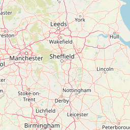
Why Peak District stands out

The Peak District is best known as Britain's original national park and for its distinctive dual-landscape character combining gritstone moorlands of the Dark Peak with the limestone valleys and gorges of the White Peak. The area is famous for its hiking opportunities, particularly the Pennine Way long-distance trail which begins at Edale. The park contains renowned natural landmarks including Mam Tor, Stanage Edge and Dovedale, as well as historic sites such as Chatsworth House, Haddon Hall and the spa town of Buxton. Castleton is known for its unique Blue John mineral, one of only a few sources worldwide.

Peak District history and protected-area timeline

Human activity in the Peak District stretches back to the Mesolithic period, as evidenced by flint artefacts and paleo-environmental remains found in caves throughout the area. Neolithic activity left monumental earthworks including barrows at Margery Hill, while the Bronze Age saw the region well-populated with agricultural communities leaving behind henges such as Arbor Low and stone circles including the Nine Ladies at Stanton Moor. Iron Age hill forts, notably at Mam Tor, demonstrate the strategic importance of the high ground.

The Romans recognized the mineral wealth of the region, establishing the settlement of Aquae Arnemetiae at modern Buxton to exploit lead deposits. Anglo-Saxon settlement by the Pecsaetan tribe gave the area its enduring name, recorded in the Anglo-Saxon Chronicle of 924 AD as Peaclond, meaning hill country. Medieval periods saw the region primarily given to sheep farming, with lead mining becoming increasingly significant from the 16th century onwards.

The Industrial Revolution transformed the landscape with cotton mills constructed in the valleys by Richard Arkwright, particularly in the Derwent and Wye valleys. Limestone quarrying expanded as lead mining declined, with the Buxton lime industry becoming particularly significant. The 1932 Kinder Trespass on Kinder Scout became a landmark event in the campaign for public access to moorland, ultimately contributing to the establishment of national parks. The Peak District National Park was formally designated on 17 April 1951.

Peak District landscape and geographic character

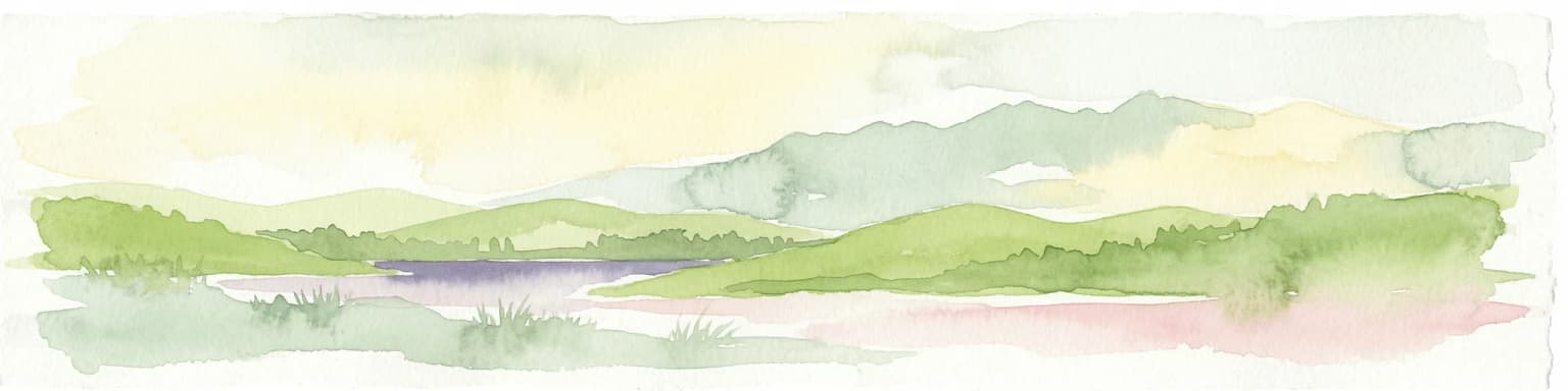
The Peak District presents a landscape of considerable variety, despite its relatively modest elevation. The most striking feature is the contrast between the Dark Peak and White Peak regions, which reflect fundamentally different geological foundations. The Dark Peak, covering the northern, eastern and western margins, is characterized by millstone grit overllying shale, creating extensive moorland plateaus, peat bogs and dramatic gritstone escarpments locally known as edges. These include Stanage Edge, The Roaches and Derwent Edge, which are popular with rock climbers.

The White Peak, occupying central and southern areas, is formed from Carboniferous limestone that has been eroded to create a landscape of narrow valleys, ravines and gorges. Dovedale, the Manifold valley and the limestone gorges around Bakewell showcase this distinctive terrain. The limestone is soluble in water, resulting in numerous caves and underground drainage systems. Thor's Cave in the Manifold valley is among the most visually striking examples. The highest point is Kinder Scout at 636 metres, a gritstone plateau that forms the focal point of the Dark Peak, though despite its name the landscape lacks sharp peaks, consisting instead of rounded hills, plateaus and valleys.

Peak District ecosystems, habitats, and plant life

The ecological character of the Peak District reflects its geology and land use history. The Dark Peak supports extensive heather moorland and blanket bog habitats on the gritty, acidic soils, with rough sheep pasture and grouse shooting as traditional land uses. The White Peak limestone plateaus are more intensively farmed, primarily for dairy production, with calcareous grasslands supporting distinctive plant communities including early purple orchid, dark-red helleborine and fly orchid.

Woodland covers approximately 8 percent of the national park, appearing naturally in the steep dales of the White Peak and the cloughs of the Dark Peak. Lead rakes, the spoil heaps from historic mining, form a distinctive habitat supporting rare metallophyte plants including spring sandwort, alpine pennycress and mountain pansy. Several endemic species are found nowhere else in the world, including Derby hawkweed at Winnats Pass and Derbyshire feather moss in a confidential limestone dale location. Jacob's-ladder, the county flower of Derbyshire since 2002, is characteristic of limestone dales in the White Peak.

Peak District wildlife and species highlights

The Peak District supports a range of wildlife, though most mammal and bird species are generalists widespread across Britain. The mountain hare population on heather moorland in the Dark Peak represents the only wild population in England, reintroduced in the Victorian era. Red deer herds are established in the upper Goyt valley and on moors above Baslow, likely derived from animals that escaped from local deer parks.

The Dark Peak moors support breeding populations of upland specialist birds including twite, short-eared owl, golden plover, dunlin, ring ouzel, northern wheatear and merlin. The twite and golden plover populations represent the southernmost confirmed breeding populations in England. The Peak District Moors Special Protection Area is designated for merlin, golden plover and short-eared owl. Fast-flowing rivers attract specialists including grey wagtail, dipper and common sandpiper. Conservation challenges include illegal persecution of raptors such as hen harrier and goshawk, and ongoing tensions between grouse shooting interests and bird of prey protection.

Peak District conservation status and protection priorities

The Peak District faces significant conservation challenges arising from its unique position as a heavily-visited protected landscape adjacent to major urban populations. The proximity of approximately 20 million people within an hour's drive creates substantial visitor pressure, particularly in hotspots like Dovedale which receives around two million visitors annually, Bakewell, Castleton and the Hope Valley. Over 60 percent of visits occur between May and September, concentrating impacts during the peak season.

Upland moorland habitats have suffered from historical industrial pollution, erosion caused by heavy visitor foot traffic and inappropriate recreational vehicle use. The south Pennine moors represent some of the most degraded upland habitats in the UK. Management for driven grouse shooting, involving rotational burning and predator control, remains controversial. The Birds of Prey Initiative has achieved limited success, with the RSPB withdrawing in 2018 due to continued illegal raptor persecution. Quarrying for limestone and gritstone continues as an important industry, though proposals for new quarries at sensitive sites like Stanton Moor have generated significant opposition.

Peak District cultural meaning and human context

The Peak District has a rich cultural heritage shaped by centuries of human habitation and economic activity. The area inspired literary works including portions of Sir Gawain and the Green Knight, sections of Pride and Prejudice by Jane Austen, and novels by Charlotte Bronte, George Eliot and Sir Walter Scott. Hathersage village is associated with Morton in Jane Eyre, and Chatsworth House has served as a filming location for numerous adaptations of classic literature.

Historic buildings within the park include Chatsworth House, seat of the Dukes of Devonshire and among Britain's finest stately homes; the medieval Haddon Hall, seat of the Dukes of Rutland; and Lyme Park, an Elizabethan manor house. Traditional customs survive including well dressing ceremonies in many villages, Castleton Garland Day and Ashbourne's Royal Shrovetide Football, played annually since the 12th century. The spa heritage of Buxton, with its thermal springs rising at a constant 28 degrees Celsius, dates to Roman times and was developed as a genteel health resort in the 18th century by the Dukes of Devonshire.

Top sights and standout views in Peak District

Peak District National Park offers exceptional walking with over 1,800 miles of public footpaths and the Pennine Way trail starting from Edale. The gritstone edges of Stanage Edge and The Roaches are world-renowned rock climbing venues, while the limestone caves of Castleton, including Blue John Cavern, Peak Cavern, Treak Cliff Cavern and Speedwell Cavern, provide unique underground experiences. Historic houses including Chatsworth House and Haddon Hall showcase architectural heritage spanning centuries. The spa town of Buxton offers Georgian architecture and cultural festivals. The park contains England's highest village and supports unique wildlife including mountain hares and southernmost breeding populations of upland birds. Traditional customs such as well dressing and the medieval Shrovetide Football at Ashbourne preserve living cultural heritage.

Best time to visit Peak District

The Peak District can be visited throughout the year, with each season offering a different character. Summer months bring the warmest temperatures and longest daylight hours, ideal for walking and outdoor activities, though this is also the busiest period with over 60 percent of annual visits concentrated between May and September. Autumn can bring colourful heather blooming on the moors and more manageable visitor numbers. Winter transforms the landscape, particularly the higher Dark Peak moors which can experience significant snowfall and extended snow cover, though some roads may become impassable. Spring sees new growth on the limestone grasslands and is a good time for wildlife watching. The climate is relatively wet, with the Dark Peak receiving more rainfall than the White Peak due to its higher elevation, and visitors should be prepared for changeable weather regardless of season.

Park location guide

Geography guide, regional context, and park location map for Peak District

Peak District park geography, regions, and map view in United Kingdom
Understand where Peak District sits in United Kingdom through a broader geographic reading of the surrounding landscape, nearby location context, and its mapped position within the national park landscape.

How Peak District fits into United Kingdom

The United Kingdom is a parliamentary constitutional monarchy located in northwestern Europe, consisting of four constituent countries: England, Scotland, Wales, and Northern Ireland. As a major global power with over 69 million residents, it maintains significant international influence in politics, economics, and culture.

Wider geography shaping Peak District in United Kingdom

The United Kingdom is an island nation located in northwestern Europe, surrounded by the Atlantic Ocean, North Sea, English Channel, Celtic Sea, and Irish Sea. It shares a land border with the Republic of Ireland to the west. The territory includes the island of Great Britain, the northeastern portion of Ireland, and most of the smaller British Isles islands.

Map view of Peak District

Use this park location map to pinpoint Peak District in United Kingdom, understand its exact geographic position, and read its mapped placement within the surrounding landscape more clearly.

Pigeon | © OpenStreetMap contributors

Location context for Peak District

CheshireDerbyshireGreater ManchesterSouth YorkshireStaffordshireWest Yorkshire
Park atlas

Trace the regional spread of protected areas, comparing landscapes surrounding Peak District National Park

Discover Other National Parks and Protected Areas Near Peak District
Delve into an atlas view of national parks and other protected areas situated near Peak District National Park, showcasing the geographic context of surrounding conservation landscapes. This focused geographic overview helps you compare diverse terrain, from gritstone moorlands to limestone valleys, and trace the regional spread of protected sites.
National parkNorth Yorkshire

Yorkshire Dales National Park: A Protected Landscape in North Yorkshire

Explore mapped boundaries and distinctive limestone terrain.

Yorkshire Dales National Park offers a rich tapestry of mapped natural landscapes, characterized by its iconic limestone valleys, U-shaped glacial formations, and rolling heather-clad moorlands. Situated within North Yorkshire, this protected area showcases a unique karst geology, evident in features like Malham Cove and extensive cave systems. The park's traditional dry-stone walls and working farms contribute to a living cultural landscape, making it a prime destination for atlas-driven geographic discovery and understanding regional terrain.

Area
2,178 km²
Established
1954
IUCN
V
Relief
Mountain
Watercolor illustration showing rolling hills, green vegetation, and a pale sky
National parkNorth Yorkshire

North York Moors National Park: Explore its Protected Landscape and Geography

Discover mapped moorland, dales, and coastlines.

The North York Moors National Park is a vital protected landscape in North Yorkshire, celebrated for its extensive heather moorland and distinctive deeply incised dales. This page provides an atlas-style exploration of the park's geography, highlighting its unique terrain, mapped boundaries, and its integral role within the regional landscape context. Understand the diverse natural features that define this iconic national park, from the upland plateau to the dramatic Jurassic coast.

Area
1,430 km²
Established
1952
IUCN
V
Relief
Upland
National parkWales

Snowdonia National Park: Protected Landscape and Map Exploration in North Wales

Mountain terrain, glacial lakes, and regional geography.

Snowdonia National Park offers a profound exploration of mountainous protected landscapes in North Wales. This page details the park's mapped boundaries, revealing a terrain shaped by glaciation, featuring dramatic peaks like Snowdon, steep valleys, and pristine glacial lakes. Understand its geographic identity within the United Kingdom and how its protected status contributes to the regional landscape context, providing a unique focus for atlas-based discovery.

Area
2,142 km²
Established
1951
Relief
Mountain
Climate
Temperate
National parkCumbria

Lake District National Park: Protected Landscape Atlas and Geographic Exploration

Mapped mountain terrain and glacial valleys in Cumbria

Delve into the geography of Lake District National Park, a protected area renowned for its dramatic mountainous terrain, U-shaped glacial valleys, and stunning natural lakes. This atlas perspective highlights the park's unique landscape features, mapped boundaries, and its significance within Cumbria, offering a comprehensive view for geographic discovery.

Area
2,292 km²
Established
1951
IUCN
V
Relief
Mountain
National parkWales

Brecon Beacons National Park: Explore Wales' Iconic Protected Mountain Landscape

Discover mapped terrain, park boundaries, and regional geography.

Brecon Beacons National Park, officially Bannau Brycheiniog, stands as a premier protected area within Wales, covering over 1,344 square kilometers of striking mountainous terrain. This national park is defined by its dramatic Old Red Sandstone ranges, including Pen y Fan, South Wales' highest peak, and features diverse landscapes from heather moorland to extensive river valleys. Its mapped boundaries encompass unique geological features, significant historical sites, and provide context for regional geographic exploration, making it a key destination for understanding protected lands in the UK.

Area
1,344 km²
Established
1957
IUCN
V
Visitors
4.4M annual
National parkNorthumberland

Northumberland National Park: England's Northernmost Protected Landscape and Dark Sky Wilderness

Explore its mapped boundaries, Roman heritage, and remote moorland terrain.

Northumberland National Park protects over 1,050 square kilometers of remote and stunning natural beauty in northern England, bordering Scotland. This page provides a structured overview of its protected landscape, focusing on its geographic context within the county of Northumberland, its designation as a National Park, and its renowned status as Europe's largest Dark Sky Park. Users can discover the park's characteristic moorland terrain, the archaeological significance of Hadrian's Wall, and the vast expanses of Kielder Forest, offering an atlas-level understanding of this unique frontier landscape.

Area
1,050 km²
Established
1956
IUCN
V
Relief
Highland
National park

The Broads National Park: Wetland Landscape, Rivers, and Regional Geography Atlas

Explore mapped waterways and protected reedbed ecosystems.

The Broads National Park offers a singular protected wetland landscape with over 200 kilometers of navigable waterways across its numerous shallow lakes, or 'broads.' Shaped by medieval peat excavations and natural processes, this area presents a unique geography of reedbeds and grazing marshes, punctuated by historic windmills. Discover the mapped extent of this protected landscape, its river systems, and its vital role in regional geography through structured atlas data.

Area
303 km²
Established
1989
IUCN
V
Relief
Lowland
National parkPembrokeshire

Pembrokeshire Coast National Park: Mapped Coastal Boundaries and Protected Landscape Atlas

Explore unique seaside terrain and regional geography.

Delve into the Pembrokeshire Coast National Park, a premier protected landscape recognized for its extraordinary coastal formations and diverse natural terrain. This atlas entry details the park's distinct mapped boundaries, from its iconic limestone cliffs and sea stacks to its sheltered estuaries and inland Preseli Hills. Understand how this significant national park contributes to the protected area map of Pembrokeshire and offers unparalleled opportunities for geographic discovery along the Welsh coast.

Area
629 km²
Established
1952
IUCN
V
Relief
Mixed relief

Common questions about visiting, size, designation, and location context for Peak District

Peak District FAQs for park facts, access, geography, and protected area context
Find quick answers about Peak District, including protected-area facts, park geography, trail and visitor context, and how the park fits into its surrounding country and regional landscape.
MoriAtlas Explorer

Continue Your Protected Areas Search Across the Global Atlas

Deepen your exploration by continuing the structured search for national parks and protected areas worldwide. Utilize the comprehensive filtering capabilities to compare different conservation landscapes and refine your understanding of global park geography. Discover more about the distribution and characteristics of protected natural areas.

Global natural geography