Mori Atlas logo
National parkPhu Sang National Park

Discover the mapped boundaries and natural terrain of this national park in northern Thailand.

Phu Sang National Park: Protected Landscape and Geographic Context in Chiang Rai Province

Phu Sang National Park represents a significant protected natural area situated within Chiang Rai Province, a region known for its mountainous terrain in the Thai highlands. As a national park, it offers a unique landscape for atlas exploration, providing insights into regional geography and the distribution of conservation lands in northern Thailand. Understanding Phu Sang National Park's boundaries and its place within the broader geographic context of the province is key to appreciating its protected status and natural character.

National ParksNorthern ThailandMountain ForestsHot Spring WaterfallsCave SystemsPhi Pan Nam Range

Phu Sang National Park

National park

Park overview

Structured park overview, official facts, and landscape profile for Phu Sang National Park

Phu Sang National Park park facts, protected area profile, and essential visitor context
Review the core facts for Phu Sang National Park, including designation, size, terrain, visitor scale, habitats, and operating context in one park-focused overview.

About Phu Sang National Park

Phu Sang National Park occupies a strategically important position in Northern Thailand's network of protected areas. The park encompasses portions of Thoeng District in Chiang Rai Province alongside Chiang Kham and Phu Sang Districts in Phayao Province. The Phi Pan Nam Range, within which the park lies, represents one of Thailand's most significant mountainous regions, forming a natural barrier between the Thai highlands and the Laotian lowlands. This mountain chain is notable for its role as a hydrological divide, with countless streams and rivers originating in these forested slopes and descending to feed the broader river systems of the region. The park's establishment in 2000 reflected growing recognition of the ecological importance of Thailand's northern mountain forests, which had faced increasing pressure from agricultural expansion and logging in preceding decades. The protected status has helped preserve both the watershed functions and biodiversity of this border region.

Quick facts and research context for Phu Sang National Park

Phu Sang National Park is situated in the Phi Pan Nam Range along the Thailand-Laos border, covering 285 square kilometers across Chiang Rai and Phayao Provinces. The park was established in 2000 and is managed by Thailand's Department of National Parks, Wildlife and Plant Conservation. Its most distinctive feature is Namtok Wang Kaew waterfall, where water emerges from a hot spring with temperatures ranging from 33 to 35 degrees Celsius. The park contains significant cave systems and serves as a watershed for multiple river systems in the region.

Park context

Deeper park guide and search-rich context for Phu Sang National Park

Phu Sang National Park history, landscape, wildlife, and travel context
Explore Phu Sang National Park through its history, landscape character, ecosystems, wildlife, conservation priorities, cultural context, and seasonal travel timing in a structured park guide built for atlas discovery and search intent.

Why Phu Sang National Park stands out

Phu Sang National Park is best known for its unique combination of hot spring-fed waterfalls and karst cave systems within a northern Thai highland forest setting. The warm-water waterfall Namtok Wang Kaew stands out as the park's signature feature, with water temperatures that remain remarkably consistent throughout the year due to geothermal heating. The park also contains extensive cave formations with stalactite and stalagmite deposits, making it significant for both geological study and adventure exploration. Its position along the Laos border places it at a biodiversity crossroads between two regional ecosystems.

Phu Sang National Park history and protected-area timeline

Phu Sang National Park was officially established in 2000 as part of Thailand's expanding network of national parks during the late twentieth and early twenty-first centuries. The creation of the park responded to growing concerns about deforestation and habitat degradation in the northern mountain regions, where a combination of commercial logging, shifting cultivation, and agricultural expansion had progressively reduced forest cover. The Department of National Parks, Wildlife and Plant Conservation assumed management responsibility, implementing protections for the watershed areas and unique geological features. The park's boundary was drawn to encompass the core areas of the Phi Pan Nam Range within Thailand, including the hot spring sources that feed the park's most notable waterfall. Visitor numbers have grown steadily, reaching approximately 111,000 in 2019, reflecting increased domestic interest in Thailand's natural parks.

Phu Sang National Park landscape and geographic character

The terrain of Phu Sang National Park is dominated by the forested ridges and valleys of the Phi Pan Nam Range, a mountainous chain running roughly north-south through the Thailand-Laos border region. Elevations within the park vary considerably, creating diverse microclimates and habitat zones across its extent. The park contains several significant cave systems where limestone formations have developed over geological time scales, creating impressive stalactite and stalagmite displays that attract both researchers and tourists. The most distinctive hydrological feature is the warm-water waterfall, where geothermal activity heats groundwater before it emerges at the surface, maintaining water temperatures around 33-35 degrees Celsius year-round. This thermal feature is unusual among Thai national parks and represents a significant geological attraction. The surrounding landscape supports mixed deciduous and evergreen forest cover across most slopes.

Phu Sang National Park ecosystems, habitats, and plant life

The forest ecosystems of Phu Sang National Park reflect the transition between Northern Thai highland and Laotian lowland biomes. The park contains significant areas of dipterocarp forest, with species such as Dipterocarpus obtusifolius, Dipterocarpus alatus, and Dipterocarpus turbinatus forming the canopy in lower elevations. Mixed forest compositions include Lagerstroemia species, Terminalia bellirica, and various dipterocarps, while higher elevations support oak and conifer associations. The forest structure provides habitat complexity that supports diverse wildlife communities. Beyond the forest zones, the cave systems and thermal waterways create additional ecological niches that support specialized species adapted to these unique conditions.

Phu Sang National Park wildlife and species highlights

The mammal fauna of Phu Sang National Park includes several notable species from the Indochinese region. The Indian muntjac, also known as the barking deer, is present in the forest understory, while larger arboreal species include the black giant squirrel. The park supports populations of Indochinese flying squirrels, which utilize the forest canopy for movement. Smaller mammals include the Burmese hare and the Java mouse-deer, a diminutive ungulate species that inhabits dense forest undergrowth. The jungle cat, a medium-sized felid native to South and Southeast Asia, represents an apex predator in the park's terrestrial ecosystems. Birdlife and invertebrate communities, while not extensively documented in available sources, contribute to the overall biodiversity of this protected area.

Phu Sang National Park conservation status and protection priorities

Phu Sang National Park serves important conservation functions as a protected watershed and biodiversity corridor in Thailand's northern highlands. The park's location along the Laos border places it within a broader transboundary landscape that facilitates wildlife movement between the two countries. The forest cover within the park helps regulate water cycles for downstream communities in both Chiang Rai and Phayao Provinces, with the mountain catchments feeding rivers that support agricultural activity across the lowlands. Protection of the cave systems preserves geological formations of scientific and educational value, while the thermal waterfall represents a unique ecosystem with specialized organisms adapted to warm water conditions.

Phu Sang National Park cultural meaning and human context

Phu Sang National Park exists within a region of Northern Thailand with rich ethnic diversity, though detailed cultural heritage information specific to the park area is limited in available sources. The park encompasses areas used historically by local communities for shifting cultivation and forest resource collection, practices that shaped the landscape prior to protected area establishment. The name Phu Sang derives from local usage, with the Thai script ภูซาง referring to the mountain area that gives the park its identity. The park's management balances conservation objectives with sustainable recreational use by local populations.

Top sights and standout views in Phu Sang National Park

The warm waterfall Namtok Wang Kaew, fed by geothermal hot springs maintaining 33-35°C temperatures year-round, represents the park's most distinctive attraction and sets it apart from other Thai protected areas. The cave systems containing stalactite and stalagmite formations offer exploration opportunities for visitors interested in karst geology. The park's position in the Phi Pan Nam Range provides scenic mountain forest landscapes typical of Thailand's northern border regions. The 285-square-kilometer protected area encompasses watershed functions critical to downstream agricultural communities.

Best time to visit Phu Sang National Park

The optimal period for visiting Phu Sang National Park coincides with Thailand's cool dry season from November through February, when temperatures are moderate and rainfall is minimal, facilitating trail access and outdoor exploration. The hot spring waterfall remains a viable attraction year-round due to its geothermal heating, though the surrounding forest exhibits different character between wet and dry seasons. The wet season from May through October brings higher visitor numbers and more lush vegetation but can limit some trail use, while the transitional months offer a balance of favorable conditions and reduced crowds.

Park location guide

Geography guide, regional context, and park location map for Phu Sang National Park

Phu Sang National Park park geography, regions, and map view in Thailand
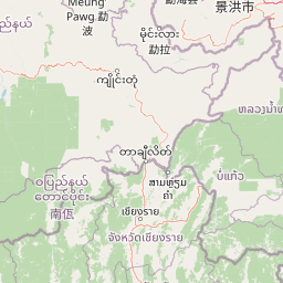
Understand where Phu Sang National Park sits in Thailand through a broader geographic reading of the surrounding landscape, nearby location context, and its mapped position within the national park landscape.

How Phu Sang National Park fits into Thailand

Thailand is a Southeast Asian nation formerly called Siam, located in mainland Southeast Asia. It operates as a unitary parliamentary constitutional monarchy under King Vajiralongkorn. The country borders Myanmar, Laos, Cambodia, and Malaysia, with maritime boundaries involving Vietnam, Indonesia, and India. Thailand has a population of nearly 66 million and covers approximately 513,120 km². Historically, the Sukhothai Kingdom marks the beginning of Thai history, followed by the powerful Ayutthaya Kingdom.

Wider geography shaping Phu Sang National Park in Thailand

Thailand occupies mainland Southeast Asia with borders to Myanmar (west/northwest), Laos (east/northeast), Cambodia (southeast), and Malaysia (south). The country has coastline along the Gulf of Thailand to the southeast and the Andaman Sea to the southwest. The territory covers approximately 513,120 km².

Map view of Phu Sang National Park

Use this park location map to pinpoint Phu Sang National Park in Thailand, understand its exact geographic position, and read its mapped placement within the surrounding landscape more clearly.

Pigeon | © OpenStreetMap contributors

Location context for Phu Sang National Park

Chiang Rai ProvincePhayao Province
Park atlas

Compare diverse mountain forests and unique protected landscapes across Northern Thailand's border regions.

Discover Nearby National Parks and Protected Areas Beyond Phu Sang National Park in Northern Thailand
Explore more national parks and protected areas near Phu Sang National Park, showcasing similar mountain forests, karst cave systems, and unique geothermal landscapes across Northern Thailand. Comparing these diverse protected areas helps understand the regional spread of conservation efforts, trace interconnected hydrological features, and reveal the broader geographic context of the Phi Pan Nam Range.
National parkPhayao Province

Doi Phu Nang National Park: Protected Landscape and Geographic Context in Phayao Province

Explore mapped boundaries and natural terrain of this national park.

Delve into the geographic specifics of Doi Phu Nang National Park, a designated national park situated in the mountainous Phayao Province of northern Thailand. This atlas-focused content highlights the park's protected land boundaries and its contribution to the regional landscape context. Understand the natural terrain and geographic distribution of conservation areas within this mountainous region.

Area
860 km²
Established
2012
IUCN
II
Visitors
35.2K annual
National parkNan Province

Doi Phu Kha National Park: National Park Protected Landscape and Geography in Nan Province

Explore mapped boundaries and natural terrain context.

Gain insight into Doi Phu Kha National Park, a protected national park situated in Nan Province, Thailand. This page offers a structured view of its geographic identity, mapped park boundaries, and the surrounding natural landscapes. It serves as a key point for understanding the park's role within Thailand's protected areas and its contribution to regional geographic context, ideal for atlas-based exploration.

Area
1,704 km²
Established
1999
IUCN
II
Visitors
63.1K annual
National parkNan Province

Khun Nan National Park: Explore its Mapped Protected Boundaries and Regional Geography

National park discovery in Nan Province, Thailand.

Khun Nan National Park is a significant protected area situated in the diverse geography of Nan Province, Thailand. As a national park, it offers critical insights into the region's natural landscapes and conservation efforts. Through an atlas-driven approach, users can explore its mapped boundaries, understand its position within the provincial geography, and gain a deeper appreciation for its role as a protected land.

Area
249 km²
Established
2009
IUCN
II
Visitors
2.6K annual
National parkThailand

Doi Luang National Park: Northern Thailand's Extensive Mountain Protected Area

Mapped terrain, forest ecosystems, and watershed significance.

Doi Luang National Park is a substantial protected landscape situated in the Phi Pan Nam Range of Northern Thailand, covering extensive mountainous territory. The park's geographic importance is highlighted by its role in protecting critical headwater ecosystems for both the Wang and Lao Rivers, featuring rugged ridgelines and significant natural terrain. Discover the mapped boundaries and conservation value of this expansive national park, integral to Thailand's regional geography and ecological health.

Area
1,169 km²
Established
1990
IUCN
II
Visitors
41K annual
Watercolor landscape featuring mountains, a lake, and trees in the foreground
National parkChiang Rai Province

Lam Nam Kok National Park: Protected Landscape Geography in Chiang Rai Province

Explore the mapped boundaries and regional context of this national park.

Lam Nam Kok National Park stands as a notable protected area within the diverse geography of Chiang Rai Province. This page provides detailed insight into its specific geographic identity, helping users understand its mapped boundaries and its significance as part of Thailand's protected natural landscapes. Discover the park's place within the regional context of the Thai highlands, facilitating a more profound atlas-driven understanding of conservation areas in northern Thailand.

Area
634.87 km²
Established
2002
IUCN
II
Visitors
197.1K annual
Watercolor painting showing green mountains, a river, and trees in a natural landscape
National parkPhrae Province

Mae Yom National Park: Protected Mountain Forest and Yom River Geography

Discover its mapped boundaries and natural teak ecosystems.

Mae Yom National Park represents a significant protected landscape in Phrae Province, Thailand, characterized by its mountainous terrain and the prominent Yom River. This national park is particularly noteworthy for its naturally growing teak forests, offering a unique glimpse into indigenous timber ecosystems within a conservation area. The park's geography features steep ridges, tributary streams feeding the main river, and distinct landscapes like the Kaeng Sua Ten rapids, providing a rich atlas context for northern Thailand's protected areas and natural terrain.

Area
455 km²
Established
1986
IUCN
II
Visitors
6.7K annual
Illustration showing steep mountain cliffs, a valley filled with clouds, and a waterfall, with pine trees in the foreground and a sun in the sky.
National parkChiang Rai Province

Khun Chae National Park: Protected Landscape and Geographic Detail in Chiang Rai Province

Explore mapped boundaries and natural terrain within Northern Thailand.

Khun Chae National Park is a designated national park offering a focused view of protected landscape geography within Chiang Rai Province. This entry provides structured details on its mapped boundaries and regional geographic context, serving as a key point for atlas-style discovery of Thailand's natural areas. Understand the park's identity as a protected landmass and its contribution to the natural geography of the Thai highlands.

Area
270 km²
Established
1995
IUCN
II
Visitors
11.2K annual
National parkNan Province

Mae Charim National Park: Protected Landscape Identity and Nan Province Geography

Explore its mapped protected area and regional landscape context.

Mae Charim National Park is a vital national park situated in Nan Province, Thailand, contributing to the region's protected landscape atlas. This entry focuses on its specific geographic identity, mapped boundaries, and its role within the natural terrain of northern Thailand. Users can delve into the park's protected status and understand its spatial relationship to the surrounding geography, offering a concrete point for detailed map exploration.

Area
432 km²
Established
2007
IUCN
II
Visitors
10.1K annual

Common questions about visiting, size, designation, and location context for Phu Sang National Park

Phu Sang National Park FAQs for park facts, access, geography, and protected area context
Find quick answers about Phu Sang National Park, including protected-area facts, park geography, trail and visitor context, and how the park fits into its surrounding country and regional landscape.
MoriAtlas Explorer

Continue Your Protected Areas Search Across the Global Atlas

Deepen your exploration by continuing the structured search for national parks and protected areas worldwide. Utilize the comprehensive filtering capabilities to compare different conservation landscapes and refine your understanding of global park geography. Discover more about the distribution and characteristics of protected natural areas.

Global natural geography