


Mori Atlas logo
National parkKhun Chae National Park

Discover the natural terrain and regional context of this key Thai national park.

Khun Chae National Park: Mapped Boundaries and Protected Landscape Geography in Chiang Rai

Khun Chae National Park represents a distinct protected natural area situated within the diverse geography of Thailand's Chiang Rai Province. This page offers an atlas-driven view of its mapped park boundaries, providing essential geographic context for understanding its place in the national park system and the broader Thai highlands landscape. Explore the core identity of Khun Chae National Park as a designated national park, focusing on its geographic features and role within the regional terrain.

mountain parkswaterfallsnorthern ThailandKhun Tan Rangetropical forestshiking destinations
Illustration showing steep mountain cliffs, a valley filled with clouds, and a waterfall, with pine trees in the foreground and a sun in the sky.

Khun Chae National Park

National park

Park overview

Structured park overview, official facts, and landscape profile for Khun Chae National Park

Khun Chae National Park park facts, protected area profile, and essential visitor context
Review the core facts for Khun Chae National Park, including designation, size, terrain, visitor scale, habitats, and operating context in one park-focused overview.

About Khun Chae National Park

Khun Chae National Park occupies a mountainous landscape in northern Thailand that forms part of the Khun Tan Range, a significant north-south trending mountain chain extending through Chiang Rai Province. The park's topography is characterized by steep, rugged terrain with elevation ranging from approximately 600 meters to the summit of Doi Lang Ka at 2,031 meters. This pronounced elevation gradient creates diverse ecological zones within the park's boundaries, supporting forest types that change with altitude from mixed deciduous and bamboo forest through pine woodland to montane evergreen forest at higher elevations. The park functions as an important watershed, with numerous streams cascading down the mountain slopes to form the waterfalls that rank among the park's most visited attractions. The landscape is relatively undeveloped, with most visitor facilities concentrated near the park headquarters while the more remote areas require multi-day treks to access. The park lies adjacent to three other protected areas, creating a contiguous block of mountain forest conservation that extends across the regional landscape. Local hill tribe communities have inhabited the surrounding areas for over a century, though the park itself is managed primarily for conservation and sustainable recreation.

Quick facts and research context for Khun Chae National Park

Khun Chae National Park occupies 270 square kilometers in the Wiang Pa Pao District of Chiang Rai Province, roughly 100 kilometers northeast of Chiang Mai city. The park lies entirely within the Khun Tan Range, a north-south mountain chain that forms part of the larger Himalayan foothills extension into northern Thailand. Doi Lang Ka at 2,031 meters is the highest peak, while Doi Mot reaches 1,700 meters and offers views toward both Chiang Mai and Chiang Rai cities. The park contains several notable waterfalls including the six-level Khun Chae waterfall and the seven-level Mae Tho waterfall, which reaches approximately 40 meters in height. The park was established in 1995 and adjoins three other national parks: Chae Son, Mae Takhrai, and Si Lanna.

Park context

Deeper park guide and search-rich context for Khun Chae National Park

Khun Chae National Park history, landscape, wildlife, and travel context
Explore Khun Chae National Park through its history, landscape character, ecosystems, wildlife, conservation priorities, cultural context, and seasonal travel timing in a structured park guide built for atlas discovery and search intent.

Why Khun Chae National Park stands out

Khun Chae National Park is best known for its dramatic mountain landscape dominated by two prominent peaks, Doi Lang Ka and Doi Mot, which provide sweeping views across the northern Thai highlands. The park's signature feature is the series of multi-tiered waterfalls, particularly the six-level Khun Chae waterfall for which the park is named, and the impressive seven-level Mae Tho waterfall. The area is also recognized for its exceptional biodiversity, with forest types that transition from bamboo and deciduous dipterocarp forest at lower elevations through pine and rainforest zones to evergreen montane forest near the peaks. The presence of large mammals including Asiatic black bear, serow, and white-handed gibbon adds to the park's conservation significance, while the giant ficus tree near park headquarters, covering over 1,600 square meters, stands as a natural landmark.
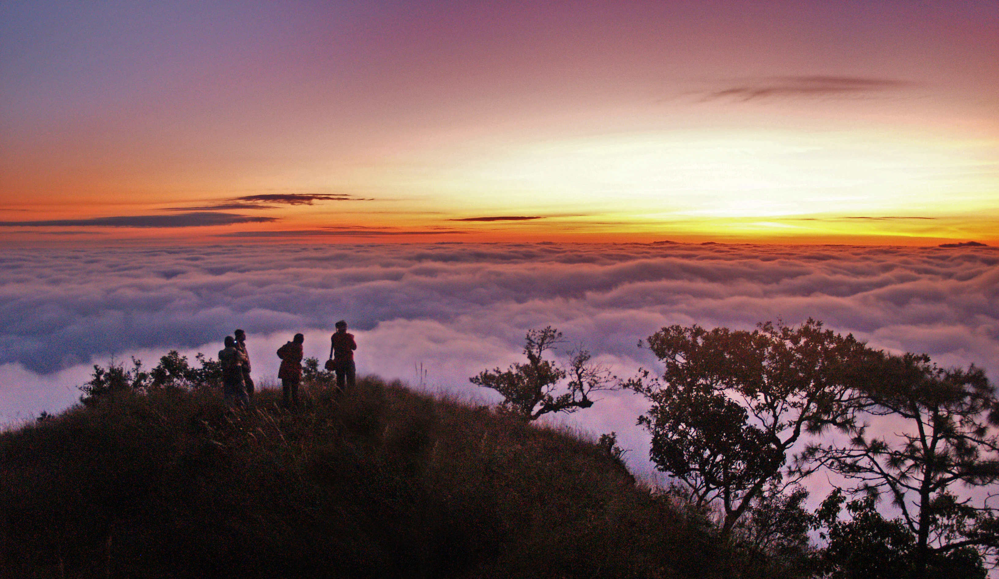
Group of hikers standing on a mountain peak with clouds below during sunrise
Hikers at a mountain summit above a sea of clouds during sunrise in Khun Chae National Park

Khun Chae National Park history and protected-area timeline

Khun Chae National Park was established in 1995 as Thailand's 73rd national park, following surveys that identified the area's significant natural and watershed values. The park's creation reflected Thailand's broader conservation strategy of the 1990s, which sought to protect representative samples of the country's diverse ecosystems within designated national parks. Prior to formal protection, the area had experienced varying degrees of human activity including shifting agriculture and selective logging, and the establishment of the park brought formal restrictions on land-use conversion and resource extraction. The Department of National Parks, Wildlife and Plant Conservation assumed management responsibility, implementing visitor facilities and trail systems while working to balance recreational access with ecological protection. The park has maintained its protected status since establishment, though visitor numbers have remained relatively modest compared to some of Thailand's more famous mountain parks, which has allowed the natural ecosystems to experience less recreational pressure.

Khun Chae National Park landscape and geographic character

The physical landscape of Khun Chae National Park is defined by the Khun Tan Range, a chain of steep, forested mountains that rise abruptly from the surrounding valley floors. The terrain is characterized by sharp ridgelines, deep valleys, and numerous small streams that have carved their way down the mountain slopes over geological time. Doi Lang Ka, the highest peak at 2,031 meters, forms a prominent backdrop visible from many parts of the park, while Doi Mot at 1,700 meters provides a secondary summit offering panoramic views toward Chiang Mai to the west and Chiang Rai to the east. The park contains an extensive drainage network, with water flowing eastward from the main watershed divide. The six-level Khun Chae waterfall and the seven-level Mae Tho waterfall represent the most significant surface water features, dropping a total of approximately 40 meters at Mae Tho. Near the park headquarters, a remarkable giant ficus tree has developed an extensive canopy covering more than 1,600 square meters, creating a distinctive landscape feature. The park's elevation range and varied aspect create diverse microclimates, with north-facing slopes supporting different vegetation patterns than those on southern exposures.

Khun Chae National Park ecosystems, habitats, and plant life

The ecological character of Khun Chae National Park reflects its elevation gradient and location in the northern Thai highlands, supporting a complex mosaic of forest types that change with altitude. Below approximately 800 meters, the lower slopes feature bamboo forest mixed with deciduous dipterocarp woodland, characterized by species adapted to seasonal dry conditions. Between 800 and 1,000 meters, the forest transitions to wet evergreen types interspersed with areas of more deciduous species. Pine forest becomes prevalent between 1,000 and 1,500 meters, with species of Pinus adapted to the cooler conditions at these elevations. Above 1,500 meters, the vegetation changes to montane evergreen forest, characterized by denser canopy, greater epiphyte diversity, and species more typical of higher latitude forests. This vertical zonation creates a variety of habitats within the park, supporting different communities of plants and animals at each elevation band. The park also serves as a critical watershed, with numerous streams and springs maintaining water flow throughout the year.

Khun Chae National Park wildlife and species highlights

Khun Chae National Park supports a diverse mammalian fauna typical of northern Thai mountain forests. Large mammals present include Asiatic black bear, Sumatran serow, and barking deer, while smaller species such as Siamese hare, hog badger, and wild boar are also recorded. Primates in the park include white-handed gibbon and slow loris, both arboreal species that inhabit the forest canopy. Carnivore species include leopard cat, with other small carnivores present in the mix. The bird community is particularly diverse, with species such as scarlet minivet, red junglefowl, shikra, ashy drongo, white-crowned forktail, brown fish owl, crested serpent eagle, and various barbets and nuthatches recorded. Reptiles include king cobra as a notable species, along with various geckos and skinks. The variety of forest types and elevation zones supports this biodiversity, with different species occupying distinct habitats within the park. The presence of large mammals like black bear and serow indicates that the park maintains relatively intact ecological communities, as these species require extensive habitat areas and are sensitive to human disturbance.

Khun Chae National Park conservation status and protection priorities

Khun Chae National Park represents an important protected area within Thailand's northern highlands, contributing to the conservation of mountain forest ecosystems that have become increasingly fragmented across the region. The park's elevation gradient captures multiple forest types in a relatively compact area, providing protected habitat for species associated with each zone. The presence of flagship species including Asiatic black bear and Sumatran serow adds conservation significance, as both species are listed as vulnerable and face habitat pressures across their ranges. As a watershed area, the park provides ecosystem services beyond biodiversity conservation, regulating water flow and protecting downstream areas from erosion and flood damage. The park's connection to three adjacent national parks creates a larger contiguous protected landscape that facilitates wildlife movement and maintains ecological processes across a broader scale. The modest visitor numbers relative to some other Thai parks reduce pressure on natural resources, though sustainable tourism management remains important for maintaining the park's conservation values.

Khun Chae National Park cultural meaning and human context

The area surrounding Khun Chae National Park has been inhabited by hill tribe communities for more than a century, with various ethnic groups maintaining traditional relationships with the land and its resources. The Thai-language sources note that these communities have lived in the vicinity for over 100 years, practicing forms of agriculture and resource use that have shaped the landscape around the park's boundaries. Within the park itself, management focuses on conservation while recognizing the cultural context of the surrounding region. The park headquarters area and main attractions are designed for visitor access, while the more remote mountain areas remain less developed. The traditional land-use practices of local communities in the缓冲区 zone around the park continue alongside the protected area management, creating a cultural landscape that surrounds the core conservation zone.

Top sights and standout views in Khun Chae National Park

The defining highlights of Khun Chae National Park are its dramatic mountain peaks and exceptional waterfalls. Doi Lang Ka, at 2,031 meters the highest peak in the Khun Tan Range, rewards hikers with panoramic views across the northern highlands, while Doi Mot at 1,700 meters offersviews toward both Chiang Mai and Chiang Rai cities. The multi-tiered waterfalls, particularly the six-level Khun Chae waterfall and the seven-level Mae Tho waterfall at approximately 40 meters high, represent the park's most accessible attractions. The giant ficus tree near park headquarters, with its expansive canopy covering over 1,600 square meters, provides a remarkable botanical landmark. The diversity of forest types across the elevation gradient creates varied hiking environments, from bamboo forest walks to montane evergreen trails near the summits. Wildlife viewing opportunities exist for patient observers, with chances to encounter gibbons, deer, and various bird species.

Best time to visit Khun Chae National Park

The best time to visit Khun Chae National Park depends on what visitors hope to experience. The cool season from November through February offers the most comfortable temperatures for hiking, with clear skies and minimal rainfall providing ideal conditions for mountain trails and waterfall viewing. This period corresponds with the northeast monsoon, which brings drier conditions to northern Thailand. The hot season from March to May brings higher temperatures, particularly at lower elevations, though the forest canopy provides some relief on trails. The wet season from June through October brings the southwest monsoon, with increased rainfall creating lush green conditions and fuller waterfalls, though trail conditions can be more difficult and some routes may be less accessible. The Thai-language sources note that winter temperatures can drop to 2-10°C, while summer maximums reach around 33°C, and average temperatures range from 22-24°C throughout the year. For waterfall viewing, the end of the wet season and early cool season typically provides the strongest water flow.

Park location guide

Geography guide, regional context, and park location map for Khun Chae National Park

Khun Chae National Park park geography, regions, and map view in Thailand
Understand where Khun Chae National Park sits in Thailand through a broader geographic reading of the surrounding landscape, nearby location context, and its mapped position within the national park landscape.

How Khun Chae National Park fits into Thailand

Thailand is a Southeast Asian nation formerly called Siam, located in mainland Southeast Asia. It operates as a unitary parliamentary constitutional monarchy under King Vajiralongkorn. The country borders Myanmar, Laos, Cambodia, and Malaysia, with maritime boundaries involving Vietnam, Indonesia, and India. Thailand has a population of nearly 66 million and covers approximately 513,120 km². Historically, the Sukhothai Kingdom marks the beginning of Thai history, followed by the powerful Ayutthaya Kingdom.

Wider geography shaping Khun Chae National Park in Thailand

Thailand occupies mainland Southeast Asia with borders to Myanmar (west/northwest), Laos (east/northeast), Cambodia (southeast), and Malaysia (south). The country has coastline along the Gulf of Thailand to the southeast and the Andaman Sea to the southwest. The territory covers approximately 513,120 km².

Map view of Khun Chae National Park

Use this park location map to pinpoint Khun Chae National Park in Thailand, understand its exact geographic position, and read its mapped placement within the surrounding landscape more clearly.

Pigeon | © OpenStreetMap contributors

Location context for Khun Chae National Park

Chiang Rai Province

Explore the dramatic terrain, lush forest habitats, and cascading scenery across this Northern Thailand protected area.

Khun Chae National Park Photos: Visualizing Thailand's Mountain Landscapes and Waterfalls
Review an extensive visual gallery of Khun Chae National Park to understand its unique mountain and waterfall landscapes in northern Thailand. This imagery provides crucial context for its steep ridges, deep valleys, diverse forest ecosystems, and prominent multi-tiered waterfalls like Khun Chae and Mae Tho, revealing the park's character for atlas-style geographic discovery.

Group of hikers standing on a mountain peak with clouds below during sunrise

Park atlas

Browse the Diverse Protected Landscapes of Northern Thailand, Comparing Regional Park Geography and Mountain Ecosystems

Explore Other Mountain Parks and Protected Areas Near Khun Chae National Park
After exploring Khun Chae National Park, trace the regional spread of other national parks and protected areas throughout northern Thailand, encompassing diverse mountain ranges, lush forests, and waterfall landscapes. Compare these mapped park geographies and conservation zones to deepen your understanding of the wider protected natural heritage in this distinct part of Southeast Asia.
National parkThailand

Doi Luang National Park: Northern Thailand's Extensive Mountain Protected Area

Mapped terrain, forest ecosystems, and watershed significance.

Doi Luang National Park is a substantial protected landscape situated in the Phi Pan Nam Range of Northern Thailand, covering extensive mountainous territory. The park's geographic importance is highlighted by its role in protecting critical headwater ecosystems for both the Wang and Lao Rivers, featuring rugged ridgelines and significant natural terrain. Discover the mapped boundaries and conservation value of this expansive national park, integral to Thailand's regional geography and ecological health.

Area
1,169 km²
Established
1990
IUCN
II
Visitors
41K annual
National parkLampang Province

Chae Son National Park: National Park Protected Landscape and Regional Geography

Mapped boundaries and natural terrain within Lampang Province.

Delve into the specifics of Chae Son National Park, a key national park situated within Lampang Province. This entry provides a structured view of its protected area status and geographic attributes. Understand the park's landscape context, its mapped boundaries, and its relation to the surrounding regional geography, offering a factual foundation for atlas-based exploration and discovery of Thailand's natural protected lands.

Area
768 km²
Established
1988
IUCN
II
Visitors
248.4K annual
National parkChiang Mai Province

Si Lanna National Park: A Protected Landscape within Chiang Mai Province

Discover its geographic context and mapped protected area identity.

Si Lanna National Park is a designated national park located in the northern Thai highlands of Chiang Mai Province. This entry provides essential geographic context, detailing the park's mapped boundaries and its place within the regional atlas. Users can explore the protected landscape's characteristics and understand its role in the diverse geography of northern Thailand, serving as a key point for atlas-driven discovery of natural areas.

Area
1,405 km²
Established
1989
IUCN
II
Visitors
89.4K annual
National parkChiang Mai Province

Doi Wiang Pha National Park: Protected Mountainous Terrain and Watershed Dynamics in Northern Thailand

Explore the geography of this vital national park's peaks and valleys.

Doi Wiang Pha National Park stands as a significant national park in Chiang Mai Province, renowned for its dramatic mountainous terrain and its crucial function as a watershed. The park's complex system of ridges and valleys, along with its central peak, Doi Wiang Pha, defines its rugged landscape. Its waters feed into the Fang and Mae Lao river systems, highlighting its ecological importance for regional agriculture and communities. Understanding Doi Wiang Pha National Park through its mapped geography reveals a key protected area within northern Thailand's atlas of natural landscapes.

Area
343.37 km²
IUCN
II
Visitors
939 annual
Relief
Mountain
National parkThailand

Doi Suthep, Pui National Park: An Atlas View of Thailand's Protected National Landscape

Explore mapped boundaries and regional geographic context.

This entry focuses on Doi Suthep, Pui National Park, detailing its role as a protected national landscape within Thailand. Users can examine its mapped territory and understand its geographic placement and regional significance, offering a focused perspective for atlas exploration and a deeper appreciation of its protected status.

Area
257 km²
Established
1981
IUCN
II
Visitors
328.7K annual
National parkMae Hong Son Province

Huai Nam Dang National Park: Northern Thailand's Mountainous Protected Landscape

Explore mapped terrain and protected area boundaries in Mae Hong Son Province.

Huai Nam Dang National Park offers a detailed look into Thailand's mountainous north, featuring rugged terrain characterized by steep slopes and deep valleys. This protected area, a key national park within Mae Hong Son Province, provides a valuable case study for understanding regional geography and landscape context. Its elevation ranges from low-lying valleys to the Doi Chang summit, contributing to its significance as a watershed and natural wilderness.

Area
1,252 km²
Established
1995
IUCN
II
Visitors
121.1K annual
National parkPhayao Province

Doi Phu Nang National Park: Protected Landscape and Geographic Context in Phayao Province

Explore mapped boundaries and natural terrain of this national park.

Delve into the geographic specifics of Doi Phu Nang National Park, a designated national park situated in the mountainous Phayao Province of northern Thailand. This atlas-focused content highlights the park's protected land boundaries and its contribution to the regional landscape context. Understand the natural terrain and geographic distribution of conservation areas within this mountainous region.

Area
860 km²
Established
2012
IUCN
II
Visitors
35.2K annual
National parkChiang Mai Province

Pha Daeng National Park: National Park in Chiang Mai Province's Mountainous Geography

Mapped protected area in the Thai highlands.

Pha Daeng National Park represents a significant protected natural area within the expansive geography of Chiang Mai Province. This national park provides a clear example of mapped conservation landscapes in Northern Thailand, contributing to the region's broader geographic identity. Users can explore the park's defined boundaries and understand its role within the mountainous terrain, offering essential context for atlas-based landscape discovery.

Area
1,123 km²
Established
2000
IUCN
II
Visitors
39.5K annual

Common questions about visiting, size, designation, and location context for Khun Chae National Park

Khun Chae National Park FAQs for park facts, access, geography, and protected area context
Find quick answers about Khun Chae National Park, including protected-area facts, park geography, trail and visitor context, and how the park fits into its surrounding country and regional landscape.
MoriAtlas Explorer

Continue Your Protected Areas Search Across the Global Atlas

Deepen your exploration by continuing the structured search for national parks and protected areas worldwide. Utilize the comprehensive filtering capabilities to compare different conservation landscapes and refine your understanding of global park geography. Discover more about the distribution and characteristics of protected natural areas.

Global natural geography