

Mori Atlas logo
National parkPhu Toei National Park

Explore the mapped boundaries and natural terrain of this key national park in Thailand.

Phu Toei National Park: Protected Landscape and Geographic Context in Suphan Buri Province

Phu Toei National Park represents a significant protected area within Suphan Buri Province, offering a distinct geographic identity for atlas exploration. This national park serves as a focal point for understanding Thailand's protected landscapes, providing insights into its natural terrain and mapped boundaries. Discover the core geographic features that define Phu Toei National Park and its place within the regional context.

National ParkMountain ForestPine ForestWaterfallCentral ThailandLesser Known Parks

Phu Toei National Park

National park

Park overview

Structured park overview, official facts, and landscape profile for Phu Toei National Park

Phu Toei National Park park facts, protected area profile, and essential visitor context
Review the core facts for Phu Toei National Park, including designation, size, terrain, visitor scale, habitats, and operating context in one park-focused overview.

About Phu Toei National Park

Phu Toei National Park represents one of Thailand's less-explored protected areas, offering a distinctive combination of mountainous terrain, forest ecosystems, and cultural significance within central Thailand's provincial landscape. The park occupies a strategic position in Dan Chang District, forming part of the larger Western Forest Complex that connects with wildlife sanctuaries and conservation areas in adjacent provinces. The landscape is characterized by a series of interconnected mountain peaks including Khao Pha Daeng, Khao Phu Toei, Khao Poo Kra Kam, Khao Pluk Mu, Khao Khon Mo, Khao Mueng Thao, Khao Pa Long, and Khao Huai Plu, all contributing to the area's complex topography. These mountains serve as the headwaters for several significant streams that eventually flow into the Khao Bua Kratum Lom reservoir, making the park an important ecological and watershed area. The park's establishment followed a formal process beginning in 1994, when the Royal Forest Department ordered surveys of the forest areas, leading to the creation of forest park designations before the Cabinet approved the national park establishment in July 1997 and formal proclamation in September 1998. The park remains relatively unknown even to residents of Suphan Buri Province itself, contributing to its status as one of Thailand's quietest national parks.

Quick facts and research context for Phu Toei National Park

Phu Toei National Park covers 317 square kilometres in Dan Chang District, Suphan Buri Province, making it the only national park in the province. The park was established on 30 September 1998 following years of conservation consideration for the forest areas in the Ong Phra, Khao Poo Kra Kam, and Khao Huai Plu national reserved forest zones. The landscape features a complex mountain range with steep slopes, with Khao Thevada (Angel Mountain) at 1,123 metres serving as the park's defining peak and a significant water source for multiple streams including Lam Takhian, Huai Lek Lai, Huai On, and Huai Ong Phra. The park received approximately 8,830 visitors in 2019, with highest visitation during the high season when about 300 people visit monthly.

Park context

Deeper park guide and search-rich context for Phu Toei National Park

Phu Toei National Park history, landscape, wildlife, and travel context
Explore Phu Toei National Park through its history, landscape character, ecosystems, wildlife, conservation priorities, cultural context, and seasonal travel timing in a structured park guide built for atlas discovery and search intent.

Why Phu Toei National Park stands out

Phu Toei National Park is best known for its natural pine forest, which is rare in central Thailand, and the striking Khao Thevada (Angel Mountain) that dominates the landscape. The park features several notable waterfalls including Takhian Khi Waterfall, Tad Yai Waterfall, and Phu Kra Ting Waterfall, along with cave systems near Khao Tu Ti that contain impressive stalactites and stalagmites. The park also contains a unique historical dimension as the site of the Lauda Air Flight 004 crash in 1991, a tragedy that claimed 223 lives and occurred in the area that would later become the national park.

Phu Toei National Park history and protected-area timeline

Phu Toei National Park was officially established on 30 September 1998 as Thailand's 85th national park, following a multi-year conservation assessment and designation process. The area had previously been part of the Ong Phra, Khao Poo Kra Kam, and Khao Huai Plu national reserved forest zones and had been classified as forest parks including Phu Toei Forest Park, Phu Kra Ting Forest Park, and Takhian Kli Forest Park. The Royal Forest Department initiated formal surveys in July 1994 (in Thai year 2537) under the direction of Forest Academic Phan Thap Antarakun, recognizing the ecological value and natural beauty of the area. The Cabinet gave in-principle approval on 1 July 1997, and the park was formally declared through a royal decree published in the Government Gazette, Volume 115, Section 67 A, dated 30 September 1998. The park carries a unique historical significance as the site of the Lauda Air Flight 004 disaster on 26 May 1991, when a Boeing 767 crashed in the area, killing 223 people. A memorial shrine has been established at the crash site, which visitors pass when traveling to the natural pine forest area.

Phu Toei National Park landscape and geographic character

The physical landscape of Phu Toei National Park consists of a complex mountain range with steep slopes forming part of the western highlands of central Thailand. The terrain is dominated by multiple interconnected peaks including Khao Pha Daeng, Khao Phu Toei, Khao Poo Kra Kam, Khao Pluk Mu, Khao Khon Mo, Khao Mueng Thao, Khao Pa Long, and Khao Huai Plu. Khao Thevada (Angel Mountain) rises as the highest point at 1,123 metres above sea level, providing panoramic views across the surrounding provinces. These mountains serve as the watershed origin for several important streams including Lam Takhian, Huai Lek Lai, Huai On, Huai Ong Phra, Huai Tha Due, and Huai Kamin, all flowing toward the Khao Bua Kratum Lom reservoir in Dan Chang District. The park's elevation and mountainous character create diverse microclimates and ecological zones throughout its terrain.

Phu Toei National Park ecosystems, habitats, and plant life

The ecological character of Phu Toei National Park is defined by its diverse forest types and the presence of one of central Thailand's few remaining natural pine forests. The park contains a mosaic of vegetation communities including natural pine forest, dry evergreen forest, mixed deciduous forest, and dipterocarp forest. The dry evergreen forest appears in lower elevations while the mixed deciduous and dipterocarp forests occupy transitional zones. The natural pine forest, located approximately 7 kilometres from the park headquarters near Ban Pa Khi, contains around 1,376 pine trees with trunk diameters of 2-3 person-arms and estimated ages of 200-300 years. This forest sits on mountain ridges where visitors can experience expansive mountain-sea views with cool breezes prevailing throughout the year. Important tree species recorded in the park include Dipterocarpus alatus (Yang), Hopea odorata (Kaching), Pterocarpus macrocarpus (Pradu), Afzelia xylocarpa (Makha), Dendrocalamus species (Phai), and Pinus species (Son).

Phu Toei National Park wildlife and species highlights

Phu Toei National Park supports abundant wildlife populations due to the presence of permanent water sources and diverse habitat types within its boundaries. The mammalian fauna includes tigers, barking deer, gibbons, bears, loris, porcupines, cobras, pythons, wild pigs, palm civets, and various monkey species. The cave systems near Khao Tu Ti serve as shelter for multiple species including bears, cobras, porcupines, mongoose, foxes, wild pigs, and bats. The streams and forest environments provide suitable habitat for diverse wildlife, though specific species lists are not comprehensively documented in available sources. The presence of apex predators such as tigers indicates a relatively intact ecosystem structure within the park's boundaries.

Phu Toei National Park conservation status and protection priorities

Phu Toei National Park functions as a critical conservation area within central Thailand's protected area network, preserving both forest ecosystems and watershed resources. The park protects one of the few remaining natural pine forest ecosystems in the central region, representing a habitat type that has become increasingly rare in Thailand. The mountain watershed areas generate important water resources that flow into downstream reservoirs, providing ecosystem services beyond the park boundaries. The park is managed by the Department of National Parks, Wildlife and Plant Conservation under the National Parks Act of 1964. The conservation significance is enhanced by the park's location connecting to broader forest complexes including the Huai Kha Khaeng Wildlife Sanctuary, a UNESCO World Heritage Site, with the Takhian Kli village area positioned along the boundary of this international conservation corridor.

Phu Toei National Park cultural meaning and human context

Phu Toei National Park exists within a landscape shaped by both natural and human history, though it does not contain major archaeological or cultural heritage sites. The area is associated with the Karen (กะเหรี่ยง) ethnic communities, particularly evident near Takhian Kli village where traditional village patterns remain. The Takhian Kli area is recognized as a weapon-free village zone and sits adjacent to the boundary of the Huai Kha Khaeng Wildlife Sanctuary, a UNESCO World Heritage Site, reflecting the integration of conservation with community land use patterns in this border region. The Lauda Air Flight 004 memorial adds a different dimension to the park's cultural landscape, serving as a historical reference point for visitors traveling to the natural pine forest area.

Top sights and standout views in Phu Toei National Park

Phu Toei National Park offers several distinct highlights for visitors seeking nature experiences in central Thailand. The natural pine forest on Phu Toei mountain ridge provides a rare opportunity to walk among ancient pine trees with sweeping mountain views and cooling breezes. The park contains multiple waterfalls including the multi-tiered Takhian Khi Waterfall, the expansive Tad Yai Waterfall, and the nine-tiered Phu Kra Ting Waterfall that flows only during the rainy season. Cave systems at Khao Tu Ti feature impressive natural rock formations including stalactites and stalagmites, with the Pha Yai cliff offering particularly dramatic scenery. The highest peak at Khao Thevada offers challenging hiking opportunities and commanding views across three provinces. The park's quiet, lesser-known character provides an authentic wilderness experience for visitors willing to explore this relatively untouched corner of Thailand's national park system.

Best time to visit Phu Toei National Park

The optimal time to visit Phu Toei National Park is during the cool dry season from November through February, when temperatures are more comfortable for hiking and outdoor activities. The park experiences a tropical climate with hot conditions in the early part of the year and rainfall throughout the year, with the heaviest precipitation occurring from August through October. During the rainy season, waterfall flow increases significantly, particularly at Phu Kra Ting Waterfall which only has water during the monsoon months. The high season for visitation brings approximately 300 monthly visitors, though this remains low compared to Thailand's more popular national parks. The natural pine forest area offers the most pleasant conditions during the cool season when mountain breezes provide comfortable temperatures even during midday.

Park location guide

Geography guide, regional context, and park location map for Phu Toei National Park

Phu Toei National Park park geography, regions, and map view in Thailand
Understand where Phu Toei National Park sits in Thailand through a broader geographic reading of the surrounding landscape, nearby location context, and its mapped position within the national park landscape.

How Phu Toei National Park fits into Thailand

Thailand is a Southeast Asian nation formerly called Siam, located in mainland Southeast Asia. It operates as a unitary parliamentary constitutional monarchy under King Vajiralongkorn. The country borders Myanmar, Laos, Cambodia, and Malaysia, with maritime boundaries involving Vietnam, Indonesia, and India. Thailand has a population of nearly 66 million and covers approximately 513,120 km². Historically, the Sukhothai Kingdom marks the beginning of Thai history, followed by the powerful Ayutthaya Kingdom.

Wider geography shaping Phu Toei National Park in Thailand

Thailand occupies mainland Southeast Asia with borders to Myanmar (west/northwest), Laos (east/northeast), Cambodia (southeast), and Malaysia (south). The country has coastline along the Gulf of Thailand to the southeast and the Andaman Sea to the southwest. The territory covers approximately 513,120 km².

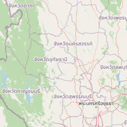
Map view of Phu Toei National Park

Use this park location map to pinpoint Phu Toei National Park in Thailand, understand its exact geographic position, and read its mapped placement within the surrounding landscape more clearly.

Pigeon | © OpenStreetMap contributors

Location context for Phu Toei National Park

Suphan Buri Province
Park atlas

Browse connected protected landscapes and regional park geography for comparative context around Phu Toei National Park.

Discover Nearby National Parks and Protected Areas Surrounding Phu Toei National Park, Thailand
Explore national parks and protected areas near Phu Toei National Park, tracing regional geography, mountain forests, and watershed landscapes across central Thailand. This comparative view offers deeper insights into the contiguous protected landscapes and conservation efforts beyond Phu Toei's specific boundaries.
National parkKanchanaburi Province

Chaloem Rattanakosin National Park: National Park Status and Geographic Exploration

Mapped protected area in Kanchanaburi Province, Thailand.

Chaloem Rattanakosin National Park represents a crucial protected landscape within Kanchanaburi Province, identified as a national park. This entry offers a foundation for understanding its geographic boundaries and regional context, providing essential detail for atlas-based exploration of Thailand's natural protected areas and their mapped distribution across the landscape.

Area
59 km²
Established
1980
IUCN
II
Visitors
31.5K annual
National parkKanchanaburi Province

Khuean Srinagarindra National Park: A Protected Landscape in Kanchanaburi Province's Geography

Explore the mapped terrain and natural context of this national park.

Khuean Srinagarindra National Park stands as a distinct protected landscape within Kanchanaburi Province. This page provides a gateway to understanding its geographic identity, mapped boundaries, and natural terrain characteristics. As a national park, it offers rich opportunities for those seeking to explore the regional geography and protected areas of Thailand through a structured, atlas-focused lens.

Area
1,532 km²
Established
1981
IUCN
II
Visitors
71K annual
National parkKanchanaburi Province

Lam Khlong Ngu National Park: A Protected National Park in Kanchanaburi Province

Explore mapped boundaries and regional geography.

Lam Khlong Ngu National Park offers a distinct protected landscape within Kanchanaburi Province. As a national park, it contributes to the understanding of Thailand's diverse geography and conservation areas. Users can explore its mapped features and discover its place within the broader regional context of protected lands.

Area
673 km²
Established
2009
Relief
Mountain
Climate
Tropical
National parkKanchanaburi Province

Khao Laem National Park: Kanchanaburi Province Protected Landscape Atlas

Discover mapped terrain and regional geographic context.

Investigate Khao Laem National Park as a distinct protected landscape situated in Thailand's Kanchanaburi Province. This entry provides detailed geographic insights, focusing on mapped boundaries and the park's position within the region's natural atlas. It's designed for users seeking specific protected-area data and landscape context rather than general visitor information.

Area
1,497 km²
Established
1991
IUCN
II
Visitors
48.6K annual
Watercolor illustration of a serene landscape featuring a body of water, distant hills, and green vegetation
National parkKanchanaburi Province

Sai Yok National Park: Protected Landscape Boundaries and Regional Geographic Context

Explore the mapped terrain and park geography within Kanchanaburi.

Sai Yok National Park serves as a vital protected area within Kanchanaburi Province, offering a clear focus for geographic exploration and atlas-based understanding. This entry details the park's specific mapped boundaries and its role within the broader regional landscape context, providing essential data for comprehending its natural geography and conservation significance.

Area
500 km²
Established
1980
IUCN
II
Visitors
67.7K annual
National parkKanchanaburi Province

Thong Pha Phum National Park: A Protected Landscape in Kanchanaburi Province, Thailand

National park mapped geography and regional context.

Thong Pha Phum National Park is a significant national park in Thailand, situated within Kanchanaburi Province. This page details its protected area status and provides essential geographic context, enabling users to explore its mapped boundaries and understand its role within the regional landscape. Focus on discovery of its natural terrain and atlas-relevant characteristics.

Area
1,236 km²
Established
2009
IUCN
II
Visitors
123.3K annual
National parkNakhon Sawan Province

Mae Wong National Park: National Park Protected Area and Geographic Setting

Mapped boundaries and regional landscape of Mae Wong.

Investigate Mae Wong National Park, a designated national park offering insights into its protected landscape identity. This entry provides structured geographic data, focusing on the park's mapped boundaries and its position within the broader regional context of Nakhon Sawan Province. Examine its role as a significant protected area for atlas-based discovery and geographic understanding.

Area
894 km²
Established
1987
IUCN
II
Visitors
51.8K annual
National parkKamphaeng Phet Province

Khlong Lan National Park: National Park Protected Landscape and Geography

Explore mapped boundaries and regional context in Kamphaeng Phet Province.

Delve into the specifics of Khlong Lan National Park, a protected area designated as a national park in Thailand's Kamphaeng Phet Province. This page offers a structured view of its geographic scope, emphasizing mapped park boundaries and the surrounding natural terrain. Understand its role as a significant protected landscape within the regional geography.

Area
300 km²
Established
1985
IUCN
II
Visitors
206.4K annual

Common questions about visiting, size, designation, and location context for Phu Toei National Park

Phu Toei National Park FAQs for park facts, access, geography, and protected area context
Find quick answers about Phu Toei National Park, including protected-area facts, park geography, trail and visitor context, and how the park fits into its surrounding country and regional landscape.
MoriAtlas Explorer

Continue Your Protected Areas Search Across the Global Atlas

Deepen your exploration by continuing the structured search for national parks and protected areas worldwide. Utilize the comprehensive filtering capabilities to compare different conservation landscapes and refine your understanding of global park geography. Discover more about the distribution and characteristics of protected natural areas.

Global natural geography