

Mori Atlas logo
Nature reserveRašeliniště Borková

A rare surviving wetland remnant defining the geography of the Vltavická brázda valley

Rašeliniště Borková Nature Reserve and Protected Peatland Landscape in Jihočeský kraj

(Přírodní rezervace Rašeliniště Borková)

Rašeliniště Borková is a vital nature reserve in the Jihočeský kraj, representing the final remnant of extensive valley peatlands lost to the construction of the Lipno reservoir. This protected area showcases a dense mosaic of bog pine woodlands, sedge marshes, and shoreline transitions that sustain rare mire invertebrates and waterfowl populations. The terrain offers a unique look at the hydrological history of the Šumava region through its distinct peat-based ecosystem.

peatlandvalley mirebog pine woodlandsedge marshwaterbird breeding siteLipno reservoir
Stylized flat-style vector illustration showing a mountain landscape with a waterfall, forest, and a birch tree in the foreground.

Rašeliniště Borková

Nature reserve

Park overview

Structured park overview, official facts, and landscape profile for Rašeliniště Borková

Rašeliniště Borková park facts, protected area profile, and essential visitor context

Review the core facts for Rašeliniště Borková, including designation, size, terrain, visitor scale, habitats, and operating context in one park-focused overview.

About Rašeliniště Borková

Rašeliniště Borková occupies a narrow but ecologically distinctive stretch of land at the edge of one of central Europe's largest reservoir systems. The reserve lies in the Vltavická brázda, a low-relief valley in the Šumava highlands, and follows the right shore of the Lipno reservoir where the Rothovský potok flows into it. Although small in size, the protected area captures an unusually complete cross-section of valley wetland vegetation in a landscape where most of the original mires were lost when the dam was constructed.

The peat itself developed over a geological base of Moldanubian migmatized paragneisses, and historical peat cutting once supplied local fuel needs, including to a brewery and to graphite mines in the region. The construction of the Lipno dam permanently altered the surrounding hydrology. The reserve reflects that change through a zoned vegetation pattern: a deforested lakeshore strip of sedge-dominated marsh, a transitional zone with surviving bog pine woodland on more stable peat, and a narrow belt of spruce-pine forest along the southern edge.

As part of the broader Šumava Protected Landscape Area, Borková functions as both a refuge for relict wetland biodiversity and a small but ecologically dense complement to the larger forested and upland systems of the Šumava. Its combination of mire, marsh, lakeshore, and marginal forest in a single small area makes it a useful reference site for understanding the pre-dam character of the Vltavická brázda.

Quick facts and research context for Rašeliniště Borková

Rašeliniště Borková is a Czech nature reserve covering roughly 48.66 hectares in the Český Krumlov district at elevations between 725 and 732 meters. It was established on 1 May 1995 by the Šumava National Park and Protected Landscape Area Administration and is classified as an IUCN Category IV area focused on species or habitat conservation. The reserve sits in the Šumava Protected Landscape Area on the right bank of the Lipno reservoir near the outlet of the Rothovský potok.

It is recognized as an important breeding site for waterbirds and protects a relict peatland ecosystem with bog pine woodland and sedge communities.

Protection and recognition

Analysis of terrestrial protected area designation and recognition records

Rašeliniště Borková Protection Status and Documented Conservation Scope

Terrestrial protection status records for Rašeliniště Borková outline the documented conservation scope and boundary framework. Official designations establish the baseline administrative profile without additional international recognition sources.

Protection details

Protection scope
Terrestrial
Transboundary protection
No
Park context

Deeper park guide and search-rich context for Rašeliniště Borková

Rašeliniště Borková history, landscape, wildlife, and travel context

Explore Rašeliniště Borková through its history, landscape character, ecosystems, wildlife, conservation priorities, cultural context, and seasonal travel timing in a structured park guide built for atlas discovery and search intent.

Why Rašeliniště Borková stands out

Rašeliniště Borková is best known as the last surviving remnant of the valley peatlands that were submerged during the creation of the Lipno reservoir. Its combine of bog pine stands, nutrient-poor sedge mires, and shoreline wetland vegetation distinguishes it within the Šumava Protected Landscape Area. The reserve also draws attention for its rare invertebrate fauna, including mire-dependent butterflies and ground beetles, and for being an important waterbird breeding locality along a stretch of the Lipno shoreline.
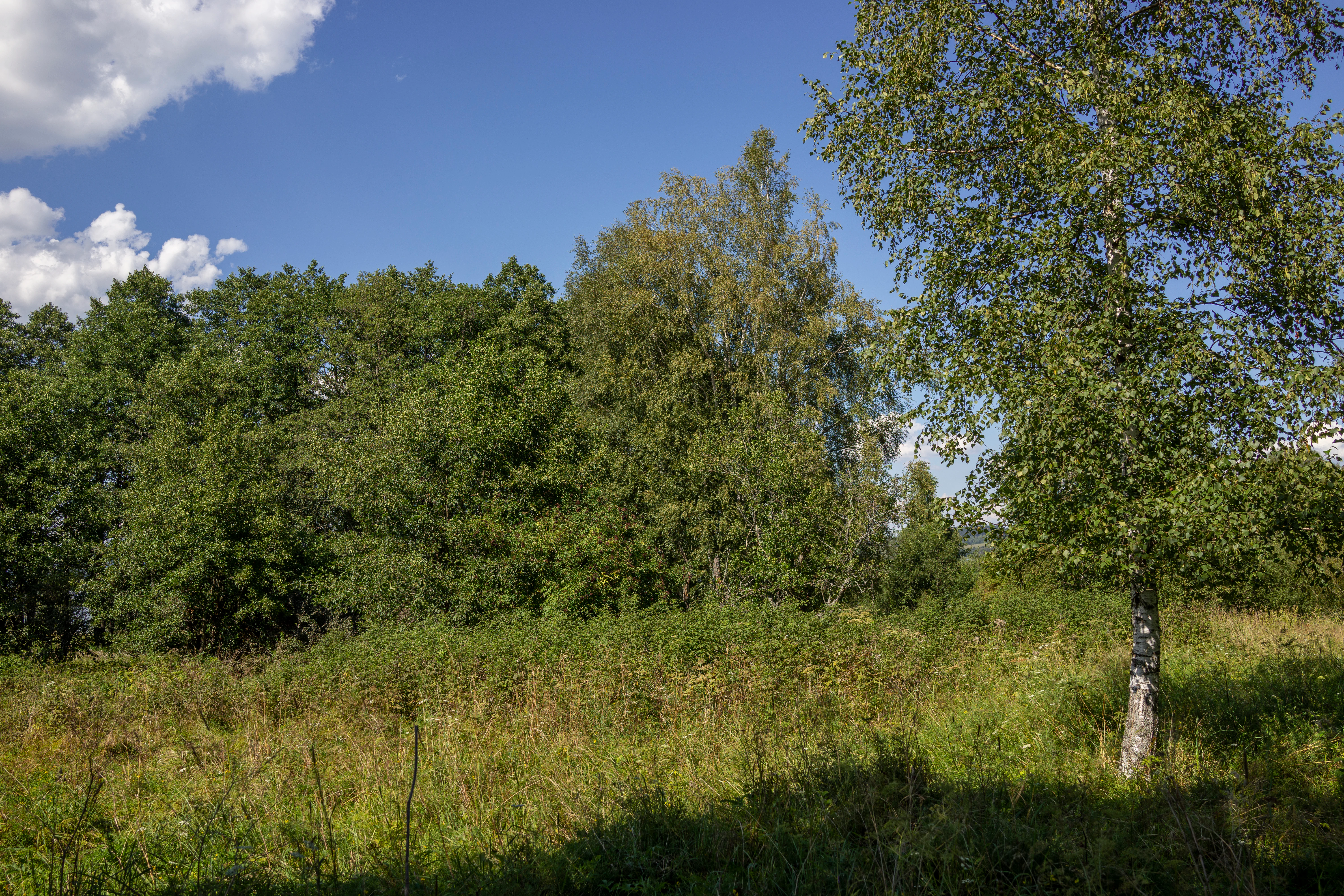
A sunny summer view of a green meadow bordered by a line of mature deciduous trees, including birch and alder, under a bright blue sky with scattered clouds.
A summer view of the woodland and meadow environment at Rašeliniště Borková nature reserve.

Rašeliniště Borková history and protected-area timeline

The site was formally protected on 1 May 1995, when it was declared a nature reserve by the Šumava National Park and Protected Landscape Area Administration. Protection came well after the construction of the Lipno reservoir in the mid-twentieth century, which flooded the majority of the original peatlands of the Vltavická brázda. The reserve was established specifically to safeguard the remaining fragment of that lost wetland system.

Earlier in the site's history, the peat had been locally exploited: it was cut for fuel, including for use in a local brewery and in graphite mines in the region. By the late twentieth century, the surviving remnant was recognized as ecologically significant both for its vegetation and for its waterbird breeding value, which justified its formal designation. The reserve has since functioned as a small protected reference of the pre-dam valley landscape within the larger Šumava Protected Landscape Area framework.

Rašeliniště Borková landscape and geographic character

Geologically, the reserve sits on Moldanubian migmatized paragneisses, which form the substrate on which the valley peat developed. The peatland itself lies within the gentle relief of the Vltavická brázda valley, at elevations between roughly 725 and 732 meters.

The contemporary landscape is shaped as much by the Lipno reservoir as by the original valley terrain. The lakeshore strip that runs through the reserve was deforested during dam construction and now forms a marshy transition between open water and drier peat. Beyond that lakeshore band, the terrain rises into surviving bog pine woodland on more stable peat, and finally into a narrow fringe of mixed spruce-pine forest along the reserve's southern boundary. The overall impression is of a compressed, finely zoned wetland landscape set against the broader backdrop of the Šumava highlands and the expansive surface of the Lipno reservoir.

Rašeliniště Borková ecosystems, habitats, and plant life

The vegetation of Rašeliniště Borková is composed of three broadly defined zones that reflect both the natural gradient away from the lakeshore and the legacy of human alteration.

Along the reservoir, a strip of sedge-dominated communities occupies ground that was cleared during the dam's construction. Within these sedge stands grow tufted loosestrife (Lysimachia thyrsiflora), slender sedge (Carex lasiocarpa), cranberry (Vaccinium oxycoccos), and bog bilberry (Vaccinium uliginosum). Moving further from the shore, the reserve transitions into a relict bog pine woodland dominated by bog pine (Pinus uncinata subsp. uliginosa), with Scots pine (Pinus sylvestris) and birch (Betula) on drier patches, and a typical bog understory of heather (Calluna) and bilberry (Vaccinium myrtillus). A narrow band of spruce-pine forest marks the southern edge of the reserve.

This combination of lakeshore marsh and surviving ombrotrophic bog woodland makes Borková an unusually compact example of a formerly extensive peatland landscape now preserved only in fragments around the Lipno reservoir.

Rašeliniště Borková wildlife and species highlights

The reserve is recognized as an important waterbird breeding site along the Lipno reservoir, a function that is closely tied to its mix of open water, marshy shoreline, and sheltered bog vegetation. The waterbird presence is one of the reasons Borková was granted formal protection.

The site is also notable for its invertebrate fauna, particularly species closely tied to peatland habitats. Mire-dependent butterflies are present, including the moorland clouded yellow (Colias palaeno) and the bog fritillary (Proclossiana eunomia). Among beetles, the ground beetle Carabus menetriesi and the heather ground beetle Cymindis vaporariorum have been recorded, along with other mire-associated carabids. In the immediate surroundings of the reserve, near the road junction by the vanished village of Kyselov, the pale orchid Dactylorhiza incarnata blooms in late May; this is reported as its only known locality on the Czech side of the Šumava.

Rašeliniště Borková conservation status and protection priorities

Rašeliniště Borková belongs to the Šumava Protected Landscape Area and holds IUCN Category IV status, reflecting its focus on conserving particular species or habitat types rather than on broad ecosystem protection. Its central conservation significance lies in preserving the last surviving fragment of the extensive valley peatlands of the Vltavická brázda, most of which were lost when the Lipno reservoir was created.

The reserve continues to support relict peatland vegetation, an unusual concentration of mire-dependent invertebrates, and a regionally important waterbird breeding habitat. Together, these values make the site a small but ecologically disproportionate reference area within the much larger Šumava conservation framework, helping to maintain biodiversity and ecological memory of a vanished wetland landscape.

Rašeliniště Borková cultural meaning and human context

The reserve sits in a landscape with a long history of modest human use. Peat was once cut here for local fuel, including for a brewery and for the region's historical graphite mines. The nearby settlement of Kyselov, which once lay at a crossroads close to the reserve, has since vanished; only the place name and a few traces remain in the cultural landscape. The area reflects a broader pattern in the Šumava region, where formerly extensive wetlands were gradually reduced through drainage, peat cutting, and ultimately the construction of the Lipno dam.

Top sights and standout views in Rašeliniště Borková

Rašeliniště Borková preserves a rare surviving fragment of the Vltavická brázda's valley peatlands, lost elsewhere beneath the Lipno reservoir, and protects a compressed sequence of wetland vegetation from lakeshore sedge marsh to bog pine woodland with relict bog flora.

It also stands out for its rich peatland invertebrate fauna, including the moorland clouded yellow butterfly and several mire-associated ground beetles, and for functioning as an important waterbird breeding site along the Lipno shore.

Best time to visit Rašeliniště Borková

Late spring and early summer are particularly rewarding at Borková: by the end of May, the rare pale orchid Dactylorhiza incarnata begins to bloom near the old crossroads at Kyselov just outside the reserve, and waterbird breeding activity along the shoreline is at its most visible. The bog pine woodland and lakeshore marsh retain their green character through summer, while the heather and bilberry understory becomes visually distinctive in late summer and early autumn. Winter visits can offer a quieter atmospheric experience of the bog landscape against the frozen surface of the Lipno reservoir, though much of the wildlife interest will be reduced at that season.
Monthly climate preview

Monthly temperature ranges and precipitation rhythm from representative coordinate data

Rašeliniště Borková Climate Normals and Long-Term Temperature Patterns

Representative climatology data reveals the recorded monthly temperature swings and precipitation rates across a multi-year baseline at Rašeliniště Borková. Examining the complete twelve-month record provides deeper insight into long-term averages and temperature extremes.
Annual mean8 °C
-3 °C18 °C
Jan-3°
Feb-1°
Mar
Apr
May13°
Jun16°
Jul18°
Aug18°
Sep13°
Oct
Nov
Dec-1°
Warmest month
July

18.3 °C

Coolest month
January

-2.8 °C

Wettest month
June

3.6 mm/day

Driest month
April

1.7 mm/day

Park location guide

Geography guide, regional context, and park location map for Rašeliniště Borková

Rašeliniště Borková park geography, regions, and map view in Czechia

Understand where Rašeliniště Borková sits in Czechia through a broader geographic reading of the surrounding landscape, nearby location context, and its mapped position within the national park landscape.

How Rašeliniště Borková fits into Czechia

Czech Republic is a landlocked Central European country with a population of approximately 10.9 million people. The nation was established as an independent state on January 1, 1993, following the dissolution of Czechoslovakia. Its capital and largest city is Prague, with other major urban centers including Brno, Ostrava, Plzeň, and Liberec.

Wider geography shaping Rašeliniště Borková in Czechia

The Czech Republic is a landlocked country in Central Europe. It is bordered by Germany to the west, Austria to the south, Poland to the northeast, and Slovakia to the southeast. The landscape is predominantly hilly, with the territory covering 78,871 square kilometers.

Map view of Rašeliniště Borková

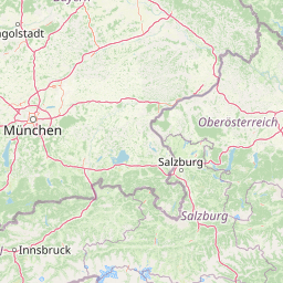
Use this park location map to pinpoint Rašeliniště Borková in Czechia, understand its exact geographic position, and read its mapped placement within the surrounding landscape more clearly.

Pigeon | © OpenStreetMap contributors

Location context for Rašeliniště Borková

Jihočeský kraj

Visual reference guide to valley peatlands, bog pine woodlands, and shoreline wetlands

Rašeliniště Borková Photos and Landscape Scenery

Visual documentation captures the rare surviving fragment of valley peatlands and bog pine woodlands along the Lipno reservoir. Photographic records reveal the complex terrain transitions from open water to sedge marsh within the protected landscape area.

A sunny summer view of a green meadow bordered by a line of mature deciduous trees, including birch and alder, under a bright blue sky with scattered clouds.

Park atlas

Compare adjacent wetland reserves and highland protected landscapes across southern Bohemia

Explore Protected Areas Near Rašeliniště Borková and Surrounding Regional Parks

Visitors exploring Rašeliniště Borková can continue discovering related protected areas and regional reserves across the surrounding Šumava landscape. Broader comparative browsing reveals connected valley peatlands, highland forests, and wetland habitats sharing the same geographic context.
Nature reserveJihočeský kraj
About 4.4 km away#1 closest

Northeast

Velké bahno Nature Reserve: Protected Wetland and Mire Geography in the Šumava Foothills

Essential conservation habitat within the Jihočeský kraj region of the Czech Republic

Velké bahno stands as a compact but vital nature reserve featuring spruce-alder swamps, wooded peatlands, and boggy clearings. Its position within the Šumava Protected Landscape Area highlights a concentration of sensitive mire habitats, protected flora, and rare species adapted to the wet, undulating paragneiss terrain of the Bohemian Forest foreland.

Area
0.915 km²
Established
1992
IUCN
IV
Relief
Upland
Watercolor illustration of a river flowing through a forested landscape with rolling hills in the background
National parkSouth Bohemian Region
About 6.3 km away#2 closest

Northwest

Šumava National Park: Czech Republic's Premier Forested National Park and Protected Landscape

Explore the unique glacial lakes, peat bogs, and regional geography.

Šumava National Park, situated in the South Bohemian Region of the Czech Republic, is the nation's largest protected area and a vital component of Central Europe's forest ecosystems. This entry details its expansive terrain, highlighting the significant peat bog complexes and ancient glacial lakes that define its unique landscape. Discover the park's geographic context, mapped boundaries, and its importance as a protected natural asset within the broader regional atlas.

Area
680.64 km²
Established
1991
IUCN
II
Visitors
2M annual
Nature reserveJihočeský kraj
About 15 km away#3 closest

Southeast

Rašeliniště Kapličky Nature Reserve: Mapped Protected Landscapes in South Bohemia

High-altitude peatland and bog pine forest geography

Rašeliniště Kapličky encompasses 73 hectares of transitional peatland in the Bohemian Forest foothills. The reserve is defined by its deep granite-based peat deposits, rare bog-pine hybrid populations, and the drainage patterns of the Lipový potok stream. This protected area serves as an essential reference for understanding upland wetland ecology and the post-industrial landscape history of the South Bohemian borderlands.

Area
1.27 km²
Established
1992
IUCN
IV
Relief
Upland
Natural monumentJihočeský kraj
About 17 km away#4 closest

Southeast

Uhlířský vrch Natural Monument: Regional Geography and Protected Forest Terrain Mapping

Mountain forest and scree woodland in the Jihočeský kraj region.

Spanning 16 hectares of northern-facing slopes near Loučovice, Uhlířský vrch stands as a vital natural monument within the Trojmezenská hornatina highlands. This record provides geographic insight into its montane habitat, elevation range, and integration into the layered conservation network of South Bohemia. Trace the boundaries and terrain features of this significant protected area in the heart of the Czech mountain landscape.

Area
0.165 km²
Established
1992
IUCN
IV
Relief
Mountain
Watercolor illustration of a soft, rolling landscape with purple hills in the distance and pale green and pink vegetation in the foreground.
Natural monumentJihočeský kraj
About 21 km away#5 closest

Northeast

Meandry Chvalšinského potoka Natural Monument: Mapped River Geography and Valley Terrain

Protected riparian habitat in the South Bohemian landscape

This natural monument protects a remarkably intact stretch of the Chvalšinský potok, where natural meanders, cut banks, and point bars create a living laboratory of fluvial geography. Beyond the stream itself, the site encompasses moist thistle and sedge meadows, offering a clear view into the traditional wetland ecology of the region. As a protected enclave, it maintains essential hydrological integrity within the broader landscape of the Czech countryside.

Area
0.048 km²
Established
2001
IUCN
IV
Relief
Lowland
Natural monumentJihočeský kraj
About 24 km away#6 closest

Northeast

Výří vrch Natural Monument: Regional Geography and Limestone Habitat Mapping

Protected limestone terrain in Jihočeský kraj

Výří vrch preserves a striking limestone inselberg that rises above the regional upland forests of the Czech Republic. The site provides a critical study in how exposed calcareous geology and warm, dry microclimates support a dense, specialized collection of steppe-like flora and invertebrate species within a broader forest-dominated landscape.

Area
0.129 km²
Established
2010
IUCN
IV
Relief
Upland
A watercolor painting of a rolling mountain landscape with forests, depicted in varying tones of green, orange, and purple, set against a white background.
Nature reserveJihočeský kraj
About 25 km away#7 closest

North

Ptačí stěna Nature Reserve: Mapped Geographic Profile of South Bohemian Protected Forests

Granulite cliff landforms and submontane beech forest mapping.

Ptačí stěna Nature Reserve occupies a steep southwestern slope in the Blanský les, defined by a linear granulite frost-riven cliff and a vast talus field of boulders up to three meters across. This protected area showcases the interplay between mature 150-year-old beech woodlands and rugged, cool microhabitats that support unique species. The site serves as a vital example of layered forest and rock conservation in South Bohemia.

Area
0.205 km²
Established
1996
IUCN
IV
Relief
Mountain
A horizontal watercolor illustration depicting soft, rolling green hills and distant pink-toned mountain silhouettes against a white background.
Natural monumentJihočeský kraj
About 29 km away#8 closest

Northeast

Na Stráži Natural Monument: Protected Grassland Geography in the Czech Republic

A botanically significant meadow in the South Bohemian landscape

Na Stráži is an important natural monument situated on a steep hillside in the Jihočeský kraj region. Known for its population of green-winged orchids and unique thermophilous acidophilic grasslands, this protected meadow provides a critical example of small-scale habitat conservation within the larger Blanský les protected landscape.

Area
0.037 km²
Established
1993
IUCN
IV
Relief
Upland

Common questions about visiting, size, designation, and location context for Rašeliniště Borková

Rašeliniště Borková FAQs for park facts, access, geography, and protected area context

Find quick answers about Rašeliniště Borková, including protected-area facts, park geography, trail and visitor context, and how the park fits into its surrounding country and regional landscape.
MoriAtlas Explorer

Continue Your Protected Areas Search Across the Global Atlas

Deepen your exploration by continuing the structured search for national parks and protected areas worldwide. Utilize the comprehensive filtering capabilities to compare different conservation landscapes and refine your understanding of global park geography. Discover more about the distribution and characteristics of protected natural areas.

Global natural geography