
Mori Atlas logo
Nature reserveRašeliniště Hovízna

Understanding the mapped boundaries and spring-fed hydrology of this South Bohemian nature reserve.

Rašeliniště Hovízna: Protected Peatland Landscape and Geographic Profile in Jihočeský kraj

(Přírodní rezervace Rašeliniště Hovízna)

Rašeliniště Hovízna serves as a protected ecological sanctuary within the Třeboň Basin of the Czech Republic. This nature reserve is defined by its unusual spring-fed peat formation, standing as a critical refuge for bog-dependent biodiversity amidst the historic fishpond landscape of Jihočeský kraj. The site offers a unique geographic perspective on how groundwater seeps and ancient water infrastructure interweave within the wider South Bohemian terrain.

peatlandmirebogwetlandspring-fed habitatrefuge habitat
A flat-style digital illustration depicting a winding river flowing through a forest of birch and evergreen trees toward a distant waterfall and mountain range under a light-colored sky.

Rašeliniště Hovízna

Nature reserve

Park overview

Structured park overview, official facts, and landscape profile for Rašeliniště Hovízna

Rašeliniště Hovízna park facts, protected area profile, and essential visitor context

Review the core facts for Rašeliniště Hovízna, including designation, size, terrain, visitor scale, habitats, and operating context in one park-focused overview.

About Rašeliniště Hovízna

Rašeliniště Hovízna is a natural reserve in the southern Czech Republic that safeguards a peatland of considerable ecological value despite its modest size. Situated in the Jindřichův Hradec District of the South Bohemian Region, the reserve occupies a quiet stretch of lowland terrain near the historic water-management network of the Třeboň Basin. The peatland is found on the right bank of the Zlatá stoka canal, a centuries-old artificial waterway that links the ponds of the Třeboň fishpond system, and lies close to Švarcenberk Pond, one of the region's signature water bodies.

The defining feature of the reserve is its hydrology. Unlike many Central European peatlands that develop through accumulation in flat basins, the Hovízna site is fed by spring seeps that emerge directly beneath the surface. This unusual configuration gives the peatland a distinctive ecological identity, even within a region like the Třeboň Basin that is already celebrated for its abundance of mires and bogs. The constant supply of cool, mineral-rich groundwater sustains saturated, oxygen-poor conditions that allow peat to build up slowly and support bog-specialist vegetation.

Beyond its geological and hydrological significance, Hovízna functions as an ecological refuge. The stable, undisturbed wet environment shelters plant and animal communities that are increasingly rare in the modern Czech countryside. The reserve is part of the wider Třeboň Protected Landscape Area (Chráněná krajinná oblast Třeboňsko), a region internationally recognized for its mosaic of fishponds, wet meadows, peatlands, and forests. Within this wider landscape, Hovízna stands out as a particularly concentrated example of how subtle hydrological differences can produce disproportionately rich biodiversity.

The reserve is administered by AOPK ČR through its regional unit responsible for the Třeboň Protected Landscape Area, which oversees conservation management, monitoring, and public guidance for the site. Because of its small footprint and ecologically sensitive conditions, the area is treated as a sanctuary rather than a recreational destination, with its primary value lying in long-term habitat preservation, scientific study, and the protection of species that depend on undisturbed peatland environments.

Quick facts and research context for Rašeliniště Hovízna

Rašeliniště Hovízna is a natural reserve (přírodní rezervace) classified as an IUCN Category IV habitat/species management area. It was established on 1 January 1995 by the Administration of the Třeboň Protected Landscape Area and is managed today by AOPK ČR, the Czech Agency for Nature Conservation and Landscape Protection.

The reserve covers a compact area of just over seven hectares in the low-lying terrain of the Třeboň Basin, lying at an elevation of roughly 414 to 417 meters above sea level. Its position near the historic Zlatá stoka canal and Švarcenberk Pond places it within a network of engineered waterways that have shaped the South Bohemian landscape for centuries, while the peatland itself retains much of its natural hydrological character.

Protection and recognition

Review the terrestrial protection framework and official management status for Rašeliniště Hovízna.

Rašeliniště Hovízna Protection Status and Documented Conservation Scope

Terrestrial protection records define the documented conservation scope and administrative framework for Rašeliniště Hovízna. Structured management parameters provide verifiable data on regional boundaries and formal area governance.

Protection details

Protection scope
Terrestrial
Park context

Deeper park guide and search-rich context for Rašeliniště Hovízna

Rašeliniště Hovízna history, landscape, wildlife, and travel context

Explore Rašeliniště Hovízna through its history, landscape character, ecosystems, wildlife, conservation priorities, cultural context, and seasonal travel timing in a structured park guide built for atlas discovery and search intent.

Why Rašeliniště Hovízna stands out

Rašeliniště Hovízna is especially known for its origin at spring seepages (pramenné vývěry), an unusual way for peat to form in a region already rich in mires like the Třeboň Basin. The spring-fed hydrology gives the site a distinct microclimate and water chemistry, supporting peat-building vegetation and associated species. The reserve is also valued as a refuge habitat, providing stable conditions for plants and animals that depend on undisturbed, waterlogged environments. Its compact size makes it less of a sweeping landscape attraction than a focused ecological sanctuary, emphasizing the diversity and fragility of Central European peat ecosystems.
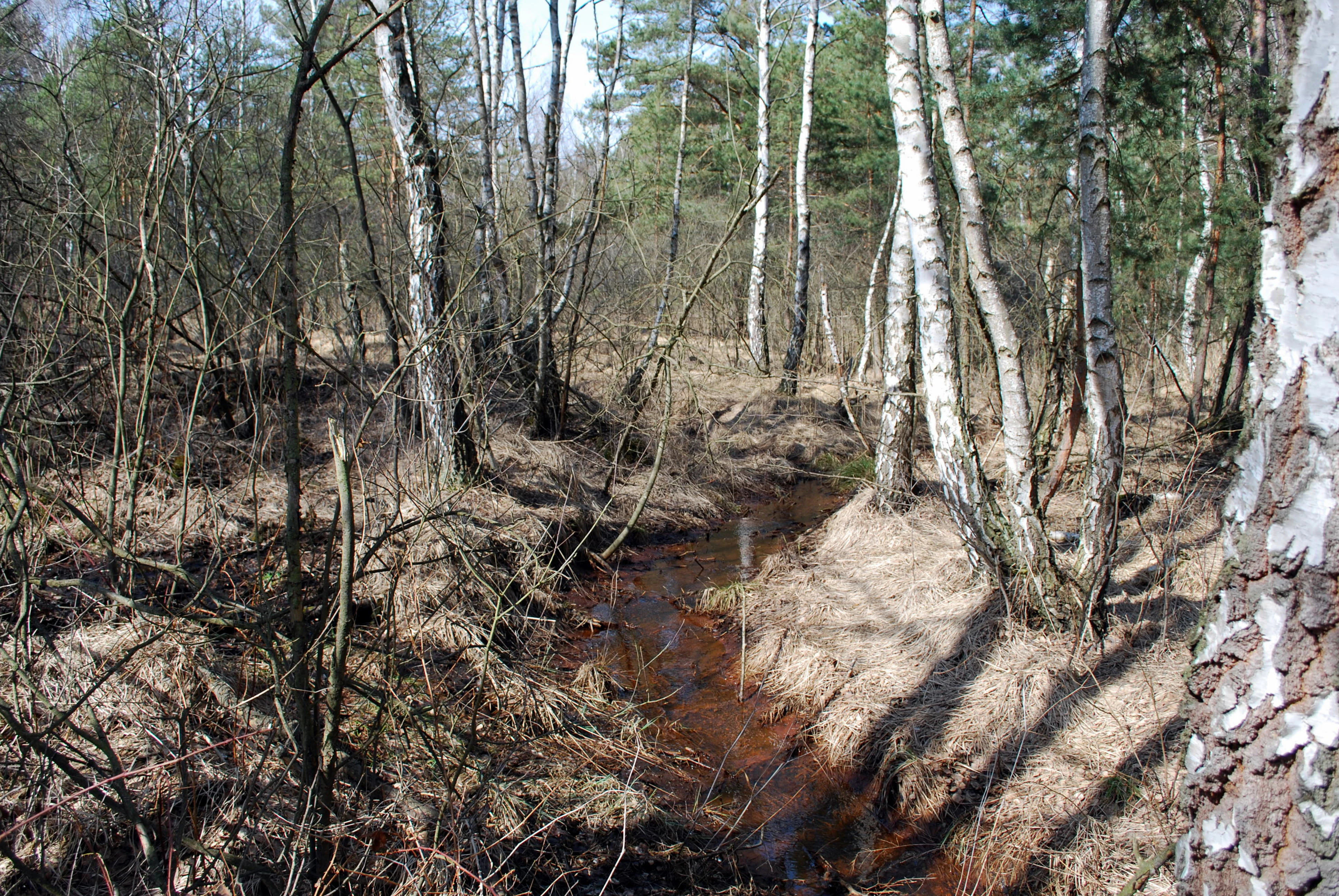
A small, narrow stream with brownish water flows through a spring-fed peat bog area with scattered birch and pine trees during early spring.
A small stream flowing through the peat bog of Rašeliniště Hovízna.

Rašeliniště Hovízna history and protected-area timeline

The protected area of Hovízna was formally established on 1 January 1995, when it was declared a natural reserve by the Administration of the Třeboň Protected Landscape Area. The designation reflected growing scientific recognition of the peatland's distinctive spring-fed character and its role as a refuge within one of the Czech Republic's most ecologically important lowland systems.

The peatland itself has clearly existed for a very long period as a natural feature of the landscape, gradually built up around groundwater discharges in a region where peat formation has been a recurring geological process. Its protection in the mid-1990s brought it under the formal conservation framework of the Czech Republic, aligning its management with the broader protection goals of the Třeboň Protected Landscape Area and the national strategy for safeguarding peatland habitats. Since its establishment, the reserve has been managed by the Czech Agency for Nature Conservation and Landscape Protection, ensuring that the site's hydrology and biological communities remain undisturbed.

Rašeliniště Hovízna landscape and geographic character

The landscape of Rašeliniště Hovízna is shaped by the subtle interplay of water, peat, and lowland terrain that defines much of the wider Třeboň Basin. The site lies at an elevation of around 414 to 417 meters above sea level, placing it firmly within the gently undulating lowland that surrounds the historic fishpond network of southern Bohemia. The terrain is flat to very gently rolling, dominated by waterlogged ground and accumulations of organic peat material rather than dramatic landforms.

A defining feature of the reserve's landscape is its proximity to the Zlatá stoka, a historic artificial canal that threads through the Třeboň Basin and connects many of its fishponds. Combined with the nearby Švarcenberk Pond, these waterways create a setting in which natural peatland processes exist alongside centuries of human water management. The contrast between the engineered pondscape of the region and the wild, groundwater-driven character of the Hovízna peatland gives the area a layered visual identity, where peatland vegetation meets the still waters and embankments of the South Bohemian pond system.
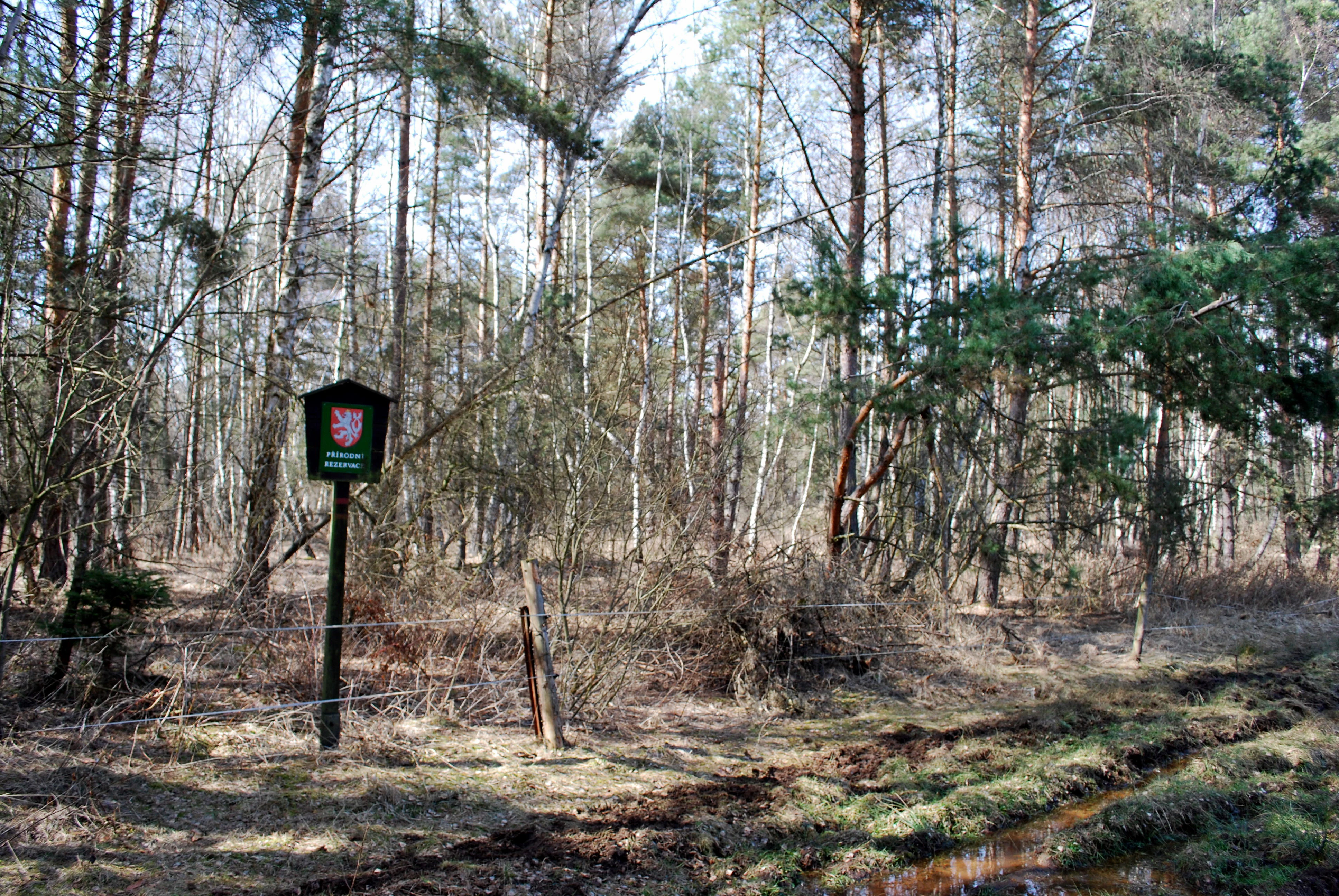
A square sign with a Czech national emblem on a post in a forest, marking a protected area boundary.
A small nature reserve boundary sign at the edge of the Rašeliniště Hovízna peat bog.

Rašeliniště Hovízna ecosystems, habitats, and plant life

The natural character of Rašeliniště Hovízna is intimately tied to its function as a spring-fed peatland within the Třeboň Basin. Continuous groundwater discharge at the site maintains the saturated, nutrient-poor, and acidic conditions that are essential for peat formation and for the specialized vegetation associated with mires and bogs. These stable, waterlogged conditions create a distinct microclimate and habitat mosaic that contrasts with the surrounding fishpond landscapes and drier forests of the region.

The reserve belongs to the wider ecological network of the Třeboň Protected Landscape Area, a region known for its peatlands, fishponds, wet meadows, and forests. Within this complex, Hovízna plays a focused role as a refuge habitat where natural hydrology remains intact. The ecological value of the site lies both in the peat-forming processes themselves and in the broader community of organisms that depend on this rare combination of stable groundwater, organic substrate, and low levels of human disturbance.

Rašeliniště Hovízna wildlife and species highlights

The wildlife value of Rašeliniště Hovízna arises primarily from the site's role as a refuge habitat within an intensively managed cultural landscape. The undisturbed spring-fed environment supports plant and animal species that require stable, waterlogged, low-disturbance conditions and that have become increasingly rare across much of Central Europe.

Because the reserve is specifically protected and managed for the integrity of its peatland environment, it provides a quiet, sheltered setting in which bog-associated species can persist. While the reserve's small size limits the presence of large mammals, its ecological character makes it important for invertebrates, amphibians, and birdlife associated with wetland habitats, as well as for specialized plant communities that thrive in undisturbed peat.

Rašeliniště Hovízna conservation status and protection priorities

Rašeliniště Hovízna is protected as a natural reserve (přírodní rezervace) and is classified under IUCN Category IV as a habitat/species management area. Its primary conservation purpose is to preserve one of the most valuable peat formations in the Třeboň Basin, with particular attention to its unusual spring-fed origin. By safeguarding this peatland, the reserve protects both a rare type of habitat and the species that depend on it.

The reserve forms part of the broader Třeboň Protected Landscape Area (Chráněná krajinná oblast Třeboňsko), one of the most important protected regions in the Czech Republic. Its conservation significance is enhanced by the surrounding mosaic of fishponds, peatlands, and forests, which together sustain ecological processes at a landscape scale. Within this network, Hovízna serves as a concentrated example of how the protection of small, ecologically distinctive sites can contribute to the long-term preservation of regional biodiversity and natural heritage.

Rašeliniště Hovízna cultural meaning and human context

The cultural context of Rašeliniště Hovízna is closely tied to the long history of water management in the Třeboň Basin. The surrounding landscape has been shaped for centuries by an intricate network of fishponds and connecting canals, including the Zlatá stoka, which passes near the reserve. This engineered pondscape represents one of the most enduring examples of human interaction with wetland environments in Central Europe.

The inclusion of a natural peatland within this heavily managed landscape reflects a broader Czech conservation tradition that recognizes the value of preserving ecological refuges alongside historic cultural landscapes. The proximity of the reserve to Švarcenberk Pond and the village of Ponědrážka situates the site within a region where traditional land use, historical engineering, and natural heritage continue to coexist.

Top sights and standout views in Rašeliniště Hovízna

The principal highlight of Rašeliniště Hovízna is its status as one of the most ecologically valuable peatlands in the Třeboň Basin, notable for being fed by spring seeps rather than typical basin-style accumulation. Its role as a refuge habitat for sensitive plant and animal species gives it an outsized conservation importance relative to its small footprint.

Equally notable is the reserve's setting within the broader Třeboň Protected Landscape Area, where the natural peatland sits beside the historic Zlatá stoka canal and Švarcenberk Pond. This combination of natural hydrology, centuries-old water infrastructure, and protected landscape status makes Hovízna a distinctive example of peatland conservation in a culturally significant Czech landscape.

Best time to visit Rašeliniště Hovízna

Because Rašeliniště Hovízna is a small, ecologically sensitive natural reserve rather than a broad recreational area, season matters more for visitor comfort and ecological awareness than for dramatic changes in scenery. Late spring and early summer tend to bring the most accessible ground conditions and the most active period for wetland flora and fauna, while autumn can offer quieter, calmer conditions for observation.

It is important for any visitor to keep in mind that the reserve's primary value is its undisturbed character. Wet, waterlogged peatlands are inherently vulnerable to trampling, so any visit should respect the site's protected status and follow guidance from the managing authority for the Třeboň Protected Landscape Area.

Monthly climate preview

Track measured monthly weather patterns and annual temperature ranges for Rašeliniště Hovízna

Rašeliniště Hovízna Climate and Long-Term Temperature Normals

Representative coordinate sampling records long-term temperature swings from sub-zero winter lows to warm summer maximums alongside consistent monthly precipitation. Reviewing full twelve-month climate normals reveals complete seasonal rhythms and detailed weather patterns across the protected landscape.
Annual mean8 °C
-3 °C19 °C
Jan-3°
Feb-2°
Mar
Apr
May13°
Jun17°
Jul19°
Aug19°
Sep13°
Oct
Nov
Dec-2°
Warmest month
July

18.7 °C

Coolest month
January

-3 °C

Wettest month
July

2.9 mm/day

Driest month
February

1.1 mm/day

Park location guide

Geography guide, regional context, and park location map for Rašeliniště Hovízna

Rašeliniště Hovízna park geography, regions, and map view in Czechia

Understand where Rašeliniště Hovízna sits in Czechia through a broader geographic reading of the surrounding landscape, nearby location context, and its mapped position within the national park landscape.

How Rašeliniště Hovízna fits into Czechia

Czech Republic is a landlocked Central European country with a population of approximately 10.9 million people. The nation was established as an independent state on January 1, 1993, following the dissolution of Czechoslovakia. Its capital and largest city is Prague, with other major urban centers including Brno, Ostrava, Plzeň, and Liberec.

Wider geography shaping Rašeliniště Hovízna in Czechia

The Czech Republic is a landlocked country in Central Europe. It is bordered by Germany to the west, Austria to the south, Poland to the northeast, and Slovakia to the southeast. The landscape is predominantly hilly, with the territory covering 78,871 square kilometers.

Map view of Rašeliniště Hovízna

Use this park location map to pinpoint Rašeliniště Hovízna in Czechia, understand its exact geographic position, and read its mapped placement within the surrounding landscape more clearly.

Pigeon | © OpenStreetMap contributors

Location context for Rašeliniště Hovízna

Jihočeský kraj

Visual reference of spring-fed peatland habitats in southern Bohemia

Rašeliniště Hovízna Landscape and Scenery Photography

Visual documentation reveals the unique spring-fed hydrology, waterlogged terrain, and specialized vegetation of the reserve. Examining authentic habitat imagery provides a clearer understanding of protected peatland ecosystems within the wider lowland basin.

A small, narrow stream with brownish water flows through a spring-fed peat bog area with scattered birch and pine trees during early spring.

A small stream with tannin-stained orange water flows through a boggy, forested landscape with thin birch and pine trees and dried brown grasses.

A square sign with a Czech national emblem on a post in a forest, marking a protected area boundary.

Park atlas

Compare nearby protected landscapes and wetland reserves across South Bohemia

Explore Other Parks Near Rašeliniště Hovízna and Regional Protected Areas

Browsing other parks near Rašeliniště Hovízna reveals the broader ecological spread of wetland reserves and protected landscapes across the Třeboň Basin. Expanding the regional comparison helps map connected groundwater habitats and lowland nature reserves throughout southern Bohemia.
Natural monumentJihočeský kraj
About 5 km away#1 closest

Northeast

Ve Farářském Natural Monument: Wetland Geography and Protected Pond Margins in South Bohemia

Detailed protected wetland terrain in the Tábo district

Ve Farářském preserves a distinctive gradient of waterlogged meadow and marsh habitats along the Farářský pond in the Czech Republic. This natural monument illustrates the ecological transition from mesotrophic grassland to willow-lined littoral zones, offering a clear view of specialized wetland plant communities within the broader South Bohemian landscape context.

Area
0.038 km²
Established
1988
IUCN
III
Relief
Lowland
A horizontal watercolor painting showing a pale landscape with faint rolling hills in the background and soft green tree silhouettes in the foreground.
Natural monumentJihočeský kraj
About 9.5 km away#2 closest

Southeast

Slepičí vršek Natural Monument: Exploring Inland Sand Dune Geography in the Třeboň Basin

Protected psammophilous landscape in Jihočeský kraj

Slepičí vršek represents a distinct eolian feature within the broader Třeboňsko landscape, characterized by its dry, undulating sandy soil and rare vegetation. This protected monument offers a clear case study for understanding inland dune development and the specialized biodiversity of relict habitats within the South Bohemian Region.

Area
0.019 km²
Established
1955
IUCN
III
Relief
Lowland
Nature reserveCzechia
About 13 km away#3 closest

Northwest

Veselská blata Nature Reserve: Basin Peatland and Wetland Geography in South Bohemia

A core protected mire site within the Czechia regional landscape.

Located in the Tábor District, Veselská blata protects rare transitional peatland ecosystems and bog pine woodlands. This reserve offers a clear view of basin mire hydrology, featuring a diverse mosaic of flooded pools and waterlogged meadows that remain vital to regional ecological conservation efforts in South Bohemia.

Area
4.538 km²
Established
2011
Relief
Lowland
Climate
Temperate
Natural monumentJihočeský kraj
About 23 km away#4 closest

Southwest

Vrbenská tůň Natural Monument: Wetland Geography and Protected Landscape Analysis

A significant oxbow wetland fragment in the South Bohemian region.

Vrbenská tůň functions as a protected natural monument focused on the conservation of lowland pond ecosystems. Located within the Jihočeský kraj, this area offers a window into the hydrology of the České Budějovice Basin, supporting specialized amphibian populations and aquatic flora within its restored basin and surrounding buffer zones.

Area
0.009 km²
Established
1974
IUCN
III
Relief
Lowland
A soft watercolor illustration of a pond landscape with grassy banks, reeds, and soft green vegetation in the background.
Nature reserveJihočeský kraj
About 28 km away#5 closest

Southwest

Rybník Motovidlo Nature Reserve: Geographic Overview and Protected Area Profile

A critical aquatic landscape within the Jihočeský kraj region

Rybník Motovidlo is a specialized nature reserve in the Czech Republic, recognized for its role in conserving endangered aquatic vegetation and providing a refuge for diverse amphibian fauna. Its geographic position within the České Budějovice Basin links it to the broader network of South Bohemian ponds. The site serves as a vital case study for the integration of traditional pond management with modern biodiversity protection in a wetland-focused environmental context.

Area
0.116 km²
Established
2022
IUCN
III
Relief
Lowland
Natural monumentJihočeský kraj
About 32 km away#6 closest

East

Vosecký rybník Natural Monument: Protected Wetland Geography in Jihočeský kraj

Rare drawdown-bottom flora and aquatic ecosystems

Located in the Javořická vrchovina highlands, Vosecký rybník is a protected natural monument known for its specialized pond-bottom vegetation. The site serves as a vital ecological corridor for threatened species within the broader mosaic of historic Bohemian fishpond landscapes.

Area
0.071 km²
Established
2022
IUCN
III
Relief
Upland
Natural monumentJihočeský kraj
About 32 km away#7 closest

West

Velký Karasín Natural Monument: Mapped Wetland Geography and Protected Landscape Context

A protected wetland sanctuary in the South Bohemian Region of the Czech Republic.

Discover the geographic character of Velký Karasín, a compact natural monument featuring an eutrophic fishpond and fringing reed beds. This protected area serves as an essential site for waterbirds and endangered dragonfly populations, offering a clear example of wetland preservation amidst the gently undulating terrain of the České Budějovice District.

Area
0.108 km²
Established
1991
IUCN
IV
Relief
Lowland
Nature reserveJihočeský kraj
About 34 km away#8 closest

Southwest

Vltava u Blanského lesa: Protected Natural Monument and River Valley Geography

Mapping the riparian landscape and conservation corridors in Jihočeský kraj

Situated in the Jihočeský kraj, Vltava u Blanského lesa is a designated nature reserve encompassing a unique river valley corridor. This area bridges the transition between aquatic river habitats and surrounding terrestrial meadows, protecting a structural mosaic essential for threatened plant and animal populations across several kilometers of the upper Vltava.

Area
4.78 km²
Established
2014
IUCN
III
Relief
Upland

Common questions about visiting, size, designation, and location context for Rašeliniště Hovízna

Rašeliniště Hovízna FAQs for park facts, access, geography, and protected area context

Find quick answers about Rašeliniště Hovízna, including protected-area facts, park geography, trail and visitor context, and how the park fits into its surrounding country and regional landscape.
MoriAtlas Explorer

Continue Your Protected Areas Search Across the Global Atlas

Deepen your exploration by continuing the structured search for national parks and protected areas worldwide. Utilize the comprehensive filtering capabilities to compare different conservation landscapes and refine your understanding of global park geography. Discover more about the distribution and characteristics of protected natural areas.

Global natural geography