
Mori Atlas logo
Biosphere reserveReserva de la biosfera de Los Ancares Lucenses y Montes de Cervantes, Navia y Becerreá

Mapping the high mountain terrain, river valleys, and biodiversity corridors of this Galician biosphere reserve.

Reserva de la Biosfera de Los Ancares Lucenses y Montes de Cervantes, Navia y Becerreá Geography and Mapped Protected Landscapes

(Reserva de la Biosfera de Los Ancares Lucenses y Montes de Cervantes, Navia y Becerreá)

Reserva de la Biosfera de Los Ancares Lucenses y Montes de Cervantes, Navia y Becerreá encompasses a rugged mountainous landscape in Lugo, Spain. This protected territory transitions from Atlantic to Mediterranean biogeographic zones, creating a complex terrain of deep river valleys and high alpine ridges. The area supports vital populations of endangered wildlife and diverse forest stands, serving as a critical example of integrated conservation and mountain geography within the northwestern Iberian Peninsula.

biosphere reserveUNESCO biospheremountain landscapeAtlantic forestsMediterranean influenceCantabrian mountains
A flat vector style illustration showing a mountain valley with a waterfall falling from a cliff into a river, surrounded by grassy slopes and coniferous trees under a soft sun.

Reserva de la biosfera de Los Ancares Lucenses y Montes de Cervantes, Navia y Becerreá

Biosphere reserve

Park overview

Structured park overview, official facts, and landscape profile for Los Ancares Lucenses Biosphere Reserve

Los Ancares Lucenses Biosphere Reserve park facts, protected area profile, and essential visitor context

Review the core facts for Los Ancares Lucenses Biosphere Reserve, including designation, size, terrain, visitor scale, habitats, and operating context in one park-focused overview.

About Los Ancares Lucenses Biosphere Reserve

Los Ancares Lucentes Biosphere Reserve is one of the most ecologically significant protected areas in Galicia. Located in the eastern mountains of Lugo province, it represents the westernmost part of the Cantabrian-Ancarine mountain system, where Atlantic influence and continental Mediterranean tendencies interact across steep ridges and deep valleys.

The reserve covers a broad mosaic of habitats, ranging from mid-elevation Atlantic deciduous forests to high-mountain grasslands, rocky outcrops, peatlands, and Mediterranean-style enclaves. This ecological complexity is one of its main defining features, allowing species with very different climatic preferences to coexist within a relatively compact geographic area.

Culturally, the area reflects the traditional Galician mountain way of life, with small rural communities, pastoral landscapes, and centuries-old land use patterns. The combination of biodiversity, dramatic relief (from valleys around 300 meters elevation to peaks above 1,900 meters), and human history gives the biosphere reserve both scientific and cultural depth.

Quick facts and research context for Los Ancares Lucenses Biosphere Reserve

Los Ancares Lucenses is a UNESCO biosphere reserve located in eastern Lugo province, Galicia, in northwestern Spain. It was designated by UNESCO in 2006 and includes the municipalities of Cervantes, Navia de Suarna, and Becerreá. The protected area covers more than 53,000 hectares and spans parts of the Sierra de Ancares and surrounding mountains along the headwaters of the Navia river basin.

Administratively managed under the Deputation of Lugo (Diputación Provincial de Lugo), the reserve layers multiple protection designations on top of its UNESCO status, including Sites of Community Importance, a Special Protection Area for birds, protected natural values zones, a National Hunting Reserve, and a Brown Bear Protection Zone.

Protection and recognition

Documented terrestrial protection scope and international recognition records

Reserva de la biosfera de Los Ancares Lucenses y Montes de Cervantes, Navia y Becerreá Protection Status

Terrestrial protection status for Reserva de la biosfera de Los Ancares Lucenses y Montes de Cervantes, Navia y Becerreá outlines recorded management scope and conservation parameters. Structured records detail official designation data and recognized international frameworks without unsupported claims.

Protection details

Protection scope
Terrestrial
Park context

Deeper park guide and search-rich context for Los Ancares Lucenses Biosphere Reserve

Los Ancares Lucenses Biosphere Reserve history, landscape, wildlife, and travel context

Explore Los Ancares Lucenses Biosphere Reserve through its history, landscape character, ecosystems, wildlife, conservation priorities, cultural context, and seasonal travel timing in a structured park guide built for atlas discovery and search intent.

Why Los Ancares Lucenses Biosphere Reserve stands out

Los Ancares Lucenses is best known for being a meeting point between Atlantic and Mediterranean ecosystems, producing unusually rich biodiversity within a single mountain landscape. Its oak and birch forests, protected holly stands, isolated holm oak patches, and westernmost European beech woodland give it strong botanical significance. The reserve is also recognized for hosting rare and threatened wildlife, including the brown bear, the endangered capercaillie, and the European crayfish, while also sustaining important populations of wolves supported by traditional extensive livestock farming and wild ungulates. The mountainous terrain of the Sierra de Ancares, slashed by deep river valleys like the Ser and the Navia, forms the defining scenic backdrop.
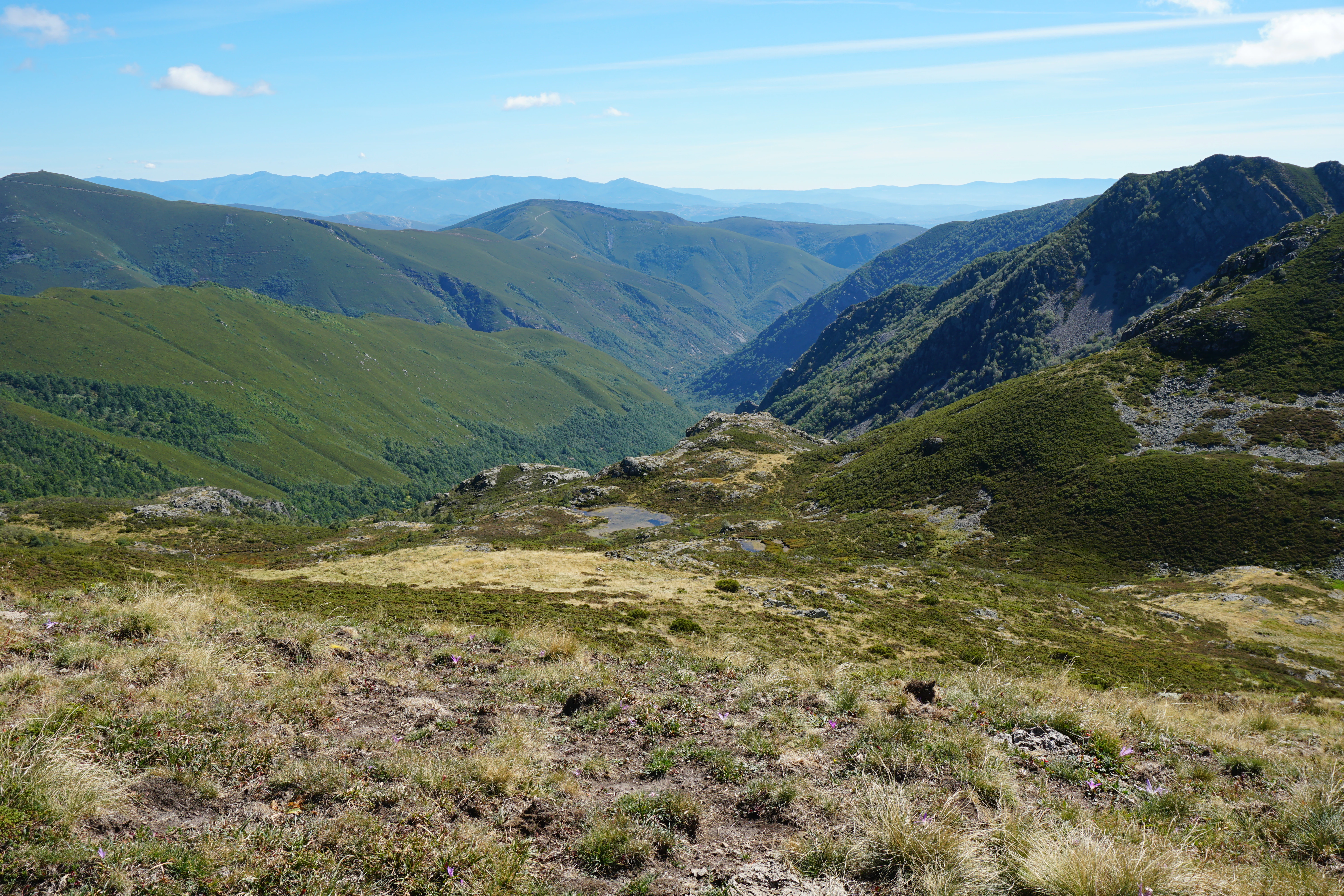
A wide, high-angle view looking down into a deep mountain valley with sloping, green, forested hills under a clear blue sky.
Panoramic view of the rolling mountain valleys within the Ancares region of Lugo, Galicia.

Los Ancares Lucenses Biosphere Reserve history and protected-area timeline

The region that now forms Los Ancares Lucenses Biosphere Reserve has long been inhabited by small mountain communities engaged in traditional agriculture and extensive livestock farming. Before its formal protection, the area was already valued for its forests, wildlife, and ecological sensitivity.

The modern protected status of the reserve was established in 2006, when UNESCO's Man and the Biosphere Programme incorporated the area into its worldwide network of biosphere reserves, formalizing recognition of its biodiversity and cultural landscape. The reserve is administered by the Deputation of Lugo (Diputación Provincial de Lugo) through the NLUDES framework.

Over time, the reserve has accumulated several overlapping protection figures, including Sites of Community Importance, a Special Protection Area for birds, zones for the protection of natural values, a National Hunting Reserve, and a Brown Bear Protection Zone, reinforcing its role in the conservation of northwestern Spain's mountain ecosystems.

Los Ancares Lucenses Biosphere Reserve landscape and geographic character

The landscape of Los Ancares Lucenses is defined by the rugged terrain of the Sierra de Ancares and the surrounding mountains of Cervantes, Navia, and Becerreá. Steep slopes, narrow valleys, and exposed ridges characterize the area, which rises from approximately 300 meters elevation along the Navia riverbed to nearly 1,935 meters at the summit of Pico Mustallar, producing a vertical relief of around 1,600 meters.

The reserve is deeply incised by the network of mountain rivers that drain into the Navia. The Ser valley, visible from many parts of the reserve, exemplifies the dramatic combination of forested slopes, small villages, and winding watercourses that shape the entire region. Above the valley floors, the terrain transitions into alpine and subalpine landscapes of open meadows, rocky plateaus, and exposed granite formations.

This combination of deep valleys, river corridors, mid-mountain forest belts, and high-altitude rocky environments produces a layered landscape where each elevation zone contributes its own visual and ecological character.
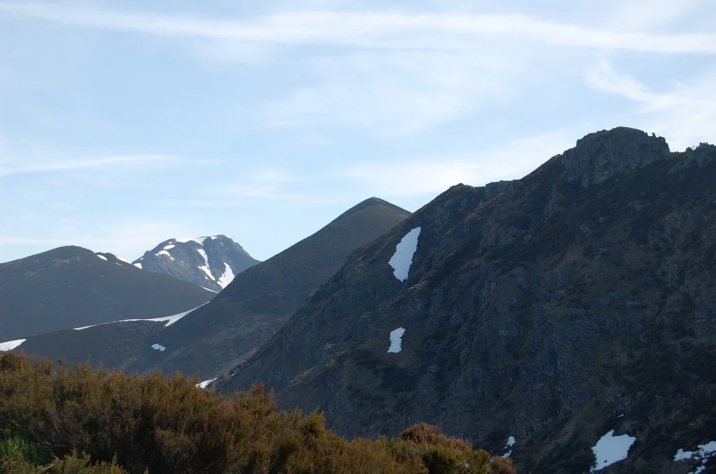
A wide mountain landscape under a light blue sky with patches of snow remaining on the slopes of dark, rocky peaks.
View of the Mustallar mountain area within the Los Ancares Lucenses biosphere reserve.

Los Ancares Lucenses Biosphere Reserve ecosystems, habitats, and plant life

Los Ancares Lucenses sits at the ecological crossroads of the Eurosiberian and Mediterranean biogeographic regions. This is why the reserve is considered so botanically rich: forests typical of Atlantic Europe grow alongside relict Mediterranean vegetation patches within a short distance of each other.

The vegetation includes extensive stands of oak and birch, protected holly (a species under protection in Galicia), and notable enclaves such as the Cruzul holm oak woodland. The reserve also contains the westernmost beech forest in Europe at the Hayedo de Pintinidoira, marking a key biogeographic boundary for this species.

The area also includes ecologically significant mire and peatland formations. The blanket bog systems are notable for their paleopalynological value, helping scientists understand past vegetation and climate patterns. The protected area registers 35 habitat types of community interest, including 10 considered priority habitat types under European conservation frameworks.

Los Ancares Lucenses Biosphere Reserve wildlife and species highlights

The wildlife of Los Ancares Lucenses reflects the overlap of Atlantic and Mediterranean influences and the diversity of habitats across elevation gradients. The reserve supports several species of high conservation interest, including the European crayfish, which is sensitive to water quality, and rare plants such as the fern Lycopodiella inundata and the bryophyte Zygodon conoideus, both considered threatened.

Among large mammals, the area is especially significant for the brown bear, whose survival in northwestern Iberia depends heavily on habitat continuity in mountain ranges such as the Ancares. The reserve also harbors one of the most important populations of the endangered capercaillie in Spain, a bird strongly associated with mature mountain forests.

Traditional extensive livestock farming and the abundance of wild ungulates have allowed wolves to maintain a stable presence across the reserve, reinforcing the area's reputation as one of the strongholds of large carnivores in northwestern Spain. This dynamic between livestock, wild ungulates, and large predators is one of the defining ecological features of the landscape.

Los Ancares Lucenses Biosphere Reserve conservation status and protection priorities

Los Ancares Lucenses plays an important role in landscape-scale conservation in northwestern Spain. Its UNESCO biosphere reserve status, granted in 2006, is reinforced by a layered set of European, national, and regional protection designations. These include Sites of Community Importance such as Os Ancares-Courel and Cruzul-Agüeira, the Ancares Special Protection Area for birds, the ZEPVN zones for natural values protection, a National Hunting Reserve, and a dedicated Brown Bear Protection Zone.

This multi-layered protection reflects the area's importance for habitats of community interest and priority habitats, including peatlands, mature deciduous forests, and Mediterranean relict woodlands. The reserve is also crucial for the conservation of endangered species such as the capercaillie, the brown bear, and sensitive aquatic species like the European crayfish.

Beyond biodiversity, the reserve contributes to conservation through the maintenance of traditional, low-intensity land use practices. Extensive livestock farming, small-scale agriculture, and locally rooted rural communities help sustain open habitats, reduce fire risk, and preserve the cultural landscape that supports both wildlife and human heritage.

Los Ancares Lucenses Biosphere Reserve cultural meaning and human context

Los Ancares Lucenses reflects a long-standing mountain culture rooted in the rural parishes and small villages of the eastern Lugo highlands. The municipalities of Cervantes, Navia de Suarna, and Becerreá share a heritage defined by livestock farming, small-scale agriculture, forestry, and seasonal transhumance traditions.

The relationship between local communities and the environment remains central to the reserve's identity. The continuation of extensive grazing practices not only shapes the landscape but also supports wildlife populations, illustrating how traditional human activity and biodiversity conservation can be tightly linked in this part of Galicia.

Architectural and vernacular heritage in the Ancares mountains, including traditional stone houses and dispersed settlements, reinforces a sense of place that is distinct from the more populous coastal and central areas of Galicia. The reserve's cultural framing emphasizes the value of sustaining these communities as part of its long-term conservation strategy.

Top sights and standout views in Los Ancares Lucenses Biosphere Reserve

Los Ancares Lucenses stands out for its concentration of ecological, geological, and cultural values in a single protected area. Its position as a meeting point between Atlantic and Mediterranean biogeographic regions gives it unusually high biodiversity for its size, while its dramatic relief, with nearly 1,600 meters of elevation difference, creates a rich layering of habitats from river valleys to alpine ridges.

Equally distinctive is its role in supporting endangered Iberian wildlife such as the brown bear and the capercaillie, alongside stable populations of wolves sustained by traditional livestock systems. The combination of UNESCO biosphere recognition, layered European protections, and a living rural mountain culture makes the reserve a particularly complete example of integrated conservation in northwestern Spain.

Best time to visit Los Ancares Lucenses Biosphere Reserve

The experience of visiting Los Ancares Lucenses changes meaningfully with the seasons. Spring and early summer are favored for vibrant deciduous forests, blooming herbaceous layers, and active birdlife, including courtship displays of species like the capercaillie in suitable habitats. These months also tend to bring the freshest greens and most visible river flow in the mountain valleys.

Autumn offers strong appeal for its foliage colors, mushroom traditions, and quieter trails, while wildlife observation can remain rewarding as ungulates become more visible and large carnivores expand their movement across the landscape. Winter transforms the area into a high-mountain environment, where higher elevations may carry snow, scenic views widen, but access to upper peaks is generally more demanding.

Summer, despite higher visitor presence, can still be a strong choice for walking through forests and connecting with the area's pastoral landscapes, since the mountain climate keeps temperatures milder than in lowland parts of Galicia.
Monthly climate preview

Long-term representative monthly averages for temperature and precipitation rhythms across the terrain

Climate Normals and Annual Temperature Patterns for Reserva de la biosfera de Los Ancares Lucenses y Montes de Cervantes, Navia y Becerreá

Representative coordinates record measured monthly temperature ranges and precipitation rhythms spanning a multi-year climatology period. Analyzing the full twelve-month profile reveals granular thermal shifts and moisture patterns across the protected landscape.
Annual mean11 °C
4 °C18 °C
Jan
Feb
Mar
Apr
May12°
Jun16°
Jul18°
Aug18°
Sep16°
Oct11°
Nov
Dec
Warmest month
July

18.4 °C

Coolest month
January

3.9 °C

Wettest month
November

3.6 mm/day

Driest month
July

0.9 mm/day

Park location guide

Geography guide, regional context, and park location map for Los Ancares Lucenses Biosphere Reserve

Los Ancares Lucenses Biosphere Reserve park geography, regions, and map view in Spain

Understand where Los Ancares Lucenses Biosphere Reserve sits in Spain through a broader geographic reading of the surrounding landscape, nearby location context, and its mapped position within the national park landscape.

How Los Ancares Lucenses Biosphere Reserve fits into Spain

Spain, officially the Kingdom of Spain, is a unitary parliamentary constitutional monarchy located in Southern and Western Europe. The country occupies most of the Iberian Peninsula and includes territories in the Mediterranean and Atlantic. With a population of approximately 49.6 million and an area of 506,030 km², Spain is a major European economy and cultural force. Its capital is Madrid, and the country is known for its diverse landscapes ranging from mountainous regions to coastal areas.

Wider geography shaping Los Ancares Lucenses Biosphere Reserve in Spain

Spain occupies the Iberian Peninsula in Southern and Western Europe. Peninsular Spain is bordered to the north by France, Andorra, and the Bay of Biscay; to the east and south by the Mediterranean Sea and Gibraltar; and to the west by Portugal and the Atlantic Ocean. The territory includes the Canary Islands in the Atlantic Ocean, the Balearic Islands in the Mediterranean Sea, and the autonomous cities of Ceuta and Melilla in mainland Africa. Spain features diverse terrain including the Pyrenees in the northeast, the Sierra Nevada in the south, and the Meseta Central plateau.

Map view of Los Ancares Lucenses Biosphere Reserve

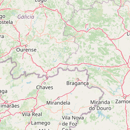
Use this park location map to pinpoint Los Ancares Lucenses Biosphere Reserve in Spain, understand its exact geographic position, and read its mapped placement within the surrounding landscape more clearly.

Pigeon | © OpenStreetMap contributors

Location context for Los Ancares Lucenses Biosphere Reserve

GaliciaLugo
Recorded earthquake history

Explore Historical Earthquake Records near the Reserva de la biosfera de Los Ancares Lucenses

Review recorded seismic activity for the Reserva de la biosfera de Los Ancares Lucenses y Montes de Cervantes, Navia y Becerreá through a curated historical catalogue. MoriAtlas provides these data points for geographic context, enabling observers to trace documented events across the mountainous terrain of the Sierra de Ancares.

Los Ancares Lucenses Earthquake History

Catalogued events

200 events

Strongest magnitude

Magnitude 5.4

Most recent event

Sep 30, 2023

This history includes earthquakes recorded inside the park or within 50 km of its borders

Visual exploration of mountain terrain, forested slopes, and protected habitats across northwestern Spain

Reserva de la biosfera de Los Ancares Lucenses y Montes de Cervantes, Navia y Becerreá Photos and Scenery

Photographic records capture the rugged topography, deep river valleys, and overlapping Atlantic and Mediterranean ecosystems defining Reserva de la biosfera de Los Ancares Lucenses y Montes de Cervantes, Navia y Becerreá. Visual documentation reveals the vertical relief, diverse forest canopies, and distinct highland characteristics shaping this protected natural landscape.

A wide, high-angle view looking down into a deep mountain valley with sloping, green, forested hills under a clear blue sky.

A wide angle view of a lush green mountain valley with small stone houses in the foreground and layers of mountain peaks fading into the distance under a pale sky.

A wide mountain landscape under a light blue sky with patches of snow remaining on the slopes of dark, rocky peaks.

Park atlas

Compare regional mountain terrain and connected protected landscapes in northwestern Spain

Parks Near Reserva de la biosfera de Los Ancares Lucenses y Montes de Cervantes, Navia y Becerreá

Browse other protected areas and mountain reserves near Reserva de la biosfera de Los Ancares Lucenses y Montes de Cervantes, Navia y Becerreá to examine broader regional park geography. Continuing into adjacent highland terrain helps place transitional ecosystems and wildlife corridors into a wider conservation context.
A soft watercolor painting depicting rolling green hills, distant mountains, a river, and stylized pink trees against a plain background.
Biosphere reserveProvincia de León
Park boundaries overlap#1 closest

East

Reserva de la biosfera de los Ancares Leoneses: Protected Mountain Terrain and Atlas

Mapping the Sierra de Ancares river valleys in Provincia de León

Examine the geographic layout and protected boundaries of the Reserva de la biosfera de los Ancares Leoneses. This biosphere reserve serves as a critical mountain corridor, featuring complex river basins and diverse forest cover that highlight the region's environmental and cultural history across the Spanish highlands.

Area
567.86 km²
Established
2006
Relief
Mountain
Scope
Terrestrial
Watercolor illustration of a gentle river winding through green hills and forests with soft, hazy mountain silhouettes in the background.
Biosphere reserveGalicia
2.1 km away#2 closest

West

Reserva de la biosfera de las Tierras del Miño: Mapped Landscapes and Geographic Overview

Extensive riverine forests and wetland networks in northwestern Spain

Explore the expansive territory of Reserva de la biosfera de las Tierras del Miño, spanning a large portion of the Galician interior. This protected area features a mosaic of wetlands, riparian corridors, and mountainous terrain, offering a deep look into the ecological and cultural geography of the upper Miño river basin.

Area
3,636.69 km²
Established
2002
Relief
Lowland
Scope
Terrestrial
A soft, horizontal watercolor painting showing a calm body of water with gentle grassy banks, trees on the left, and distant rolling hills.
Biosphere reserveGalicia
64 km away#3 closest

West

Reserva de la biosfera de las Mariñas Coruñesas y Tierras del Mandeo: Regional Geography and Maps

A diverse protected area across Galicia, Spain

This biosphere reserve serves as a vital ecological refuge along the Cantabrian-Atlantic coast. The protected area features a unique mosaic of marine and terrestrial habitats, ranging from rocky coastal cliffs and sandy estuaries to dense Atlantic forest fragments and the mountainous interior of the Sierra de la Cova da Serpe.

Area
1,139.7 km²
Established
2013
Relief
Mixed relief
Climate
Temperate
A watercolor painting showing a soft-toned landscape with a stone arch bridge spanning a river, framed by trees and gentle hills.
Biosphere reserveGalicia
82 km away#4 closest

Southwest

Área de Allariz Biosphere Reserve: Mapping the Protected Landscapes of Inland Galicia

Exploring the river basins, granitic massifs, and ecological frontiers

The Área de Allariz biosphere reserve serves as a vital transition zone in northwestern Spain, characterized by its flat-floored tectonic basin, the River Limia, and varied highland terrain. This protected area offers an instructive look at the integration of traditional rural land management with large-scale ecological recovery and conservation across its core, buffer, and transition zones.

Area
214.82 km²
Established
2005
Relief
Mixed relief
Scope
Terrestrial
Watercolor depiction of green hills, a small pond, and distant mountains under a soft sky.
Protected landscapeBragança District
82 km away#5 closest

South

Montesinho Natural Park: Protected Landscape in Bragança District, Portugal

Explore mapped boundaries and regional landscape context.

Montesinho Natural Park is designated as a protected landscape in northeastern Portugal, located within the administrative region of Bragança District. This page serves as an entry point to understanding the park's protected area characteristics, its mapped geographic footprint, and its role in the broader natural landscape of the Trás-os-Montes region. Discover the atlas value of this significant protected territory and its relation to surrounding geography.

Area
742.25 km²
Established
1979
IUCN
V
Relief
Mountain
Watercolor illustration of a river winding through a valley with mountains, forests, and pink flowering trees.
National parkPortugal
114 km away#6 closest

Southwest

Peneda-Gerês National Park: A Distinct Protected Landscape in Northern Portugal

Granite peaks, glacial valleys, and cultural heritage mapped.

Peneda-Gerês National Park represents a cornerstone of protected landscapes in Portugal, celebrated for its rugged granite mountains and deep glacial valleys sculpted over millennia. This national park showcases a rare ecological transition zone with unique endemic species and features dramatic waterfalls and pristine river systems. The park's rich cultural tapestry, interwoven with its natural environment, offers a compelling subject for atlas-based geographic discovery and landscape exploration.

Area
695.93 km²
Established
1971
IUCN
II
Visitors
92.8K annual
Watercolor illustration of rolling green hills and distant purple mountains under a light sky
National parkGalicia
133 km away#7 closest

West

Atlantic Islands of Galicia National Park: Protected Archipelagos & Galician Coastline Geography

Explore mapped island ecosystems and protected marine areas.

Uncover the protected landscape of the Atlantic Islands of Galicia National Park, Spain's only national park in Pontevedra province. This atlas entry details the four distinct archipelagos, Cíes, Ons, Sálvora, and Cortegada, across the Rías Baixas. Discover the unique sea-land protected area, its rare bay laurel forests, significant seabird colonies, and the broader regional geography of Galicia.

Area
84.8 km²
Established
2002
IUCN
II
Visitors
472.3K annual
Watercolor illustration of a mountain landscape with green forests and a body of water.
National parkSpain
142 km away#8 closest

East

Picos de Europa National Park: Dramatic Limestone Peaks and Protected Landscape Atlas

Explore Spain's historic national park and UNESCO Biosphere Reserve.

Picos de Europa National Park offers an unparalleled exploration of dramatic limestone peaks, deep glacial valleys, and extensive Atlantic forests. As Spain's oldest national park and a UNESCO Biosphere Reserve, it presents a remarkable study in karst landscape evolution and biodiversity conservation. This protected area, spanning significant territory across northern Spain, provides a rich geographic context for understanding regional natural heritage and mapped natural features.

Area
671.27 km²
Established
1918
IUCN
II
Relief
Mountain

Common questions about visiting, size, designation, and location context for Los Ancares Lucenses Biosphere Reserve

Los Ancares Lucenses Biosphere Reserve FAQs for park facts, access, geography, and protected area context

Find quick answers about Los Ancares Lucenses Biosphere Reserve, including protected-area facts, park geography, trail and visitor context, and how the park fits into its surrounding country and regional landscape.
MoriAtlas Explorer

Continue Your Protected Areas Search Across the Global Atlas

Deepen your exploration by continuing the structured search for national parks and protected areas worldwide. Utilize the comprehensive filtering capabilities to compare different conservation landscapes and refine your understanding of global park geography. Discover more about the distribution and characteristics of protected natural areas.

Global natural geography