

Mori Atlas logo
Wildlife reserveReserva de Producción de Fauna Cuyabeno

Understanding the hydrological landscape of seasonally flooded forests and blackwater river networks

Reserva de Producción de Fauna Cuyabeno: Mapping a Vast Amazonian Protected Wildlife Reserve

Reserva de Producción de Fauna Cuyabeno stands as a major protected landscape in the northeastern Amazon region of Ecuador, encompassing extensive tracts of humid tropical forest within the Sucumbíos province. This wildlife reserve features a complex mosaic of varzea floodplains, moriche palm swamps, and permanent lagoon systems, shaped by the seasonal pulse of the Aguarico and Cuyabeno river corridors. The terrain transitions from Andean foothills to flat Amazonian lowlands, providing a critical habitat for diverse fauna and sustaining the ancestral territories of indigenous Cofán and Siona-Secoya communities.

Amazon rainforestflooded forestmoriche palm swampsblackwater riversvarzea and igapo forestsfreshwater lagoons

Reserva de Producción de Fauna Cuyabeno

Wildlife reserve

Park overview

Structured park overview, official facts, and landscape profile for Cuyabeno Fauna Production Reserve

Cuyabeno Fauna Production Reserve park facts, protected area profile, and essential visitor context

Review the core facts for Cuyabeno Fauna Production Reserve, including designation, size, terrain, visitor scale, habitats, and operating context in one park-focused overview.

About Cuyabeno Fauna Production Reserve

The Reserva de Producción de Fauna Cuyabeno is a landmark protected area in the northwestern Amazon, occupying a vast block of lowland tropical rainforest in Ecuador's Sucumbíos province. Together with Yasuní National Park to the south, Cuyabeno anchors one of the most biologically intense regions on Earth, where the Andes give way abruptly to the flat expanse of the Amazon basin and where a complex hydrological network shapes nearly every aspect of the ecosystem.

The reserve's geography is dominated by slow-moving rivers and a system of interconnected lagoons rather than towering mountains or dramatic cliffs. The Cuyabeno and Aguarico rivers, along with the Tarapuy and upper tributaries, braid through the landscape, and during the rainy season they flood enormous tracts of forest. Some of these inundated areas are dominated by Mauritia flexuosa palms and form the characteristic morichales, while others are várzea forests enriched by sediment-laden whitewater rivers or the dark, nutrient-poor igapó forests fed by blackwater streams. Permanent lakes such as Zancudo Cocha sit alongside semi-permanent lagoons like Laguna Grande, which dry out in some years and host famous Macrolobium trees laden with epiphytes in others.

This variability in flooding, soil, and elevation creates a mosaic of habitats with very different flora and fauna. The flooded forests are relatively species-poor, while the better-drained terra firme forests on low hills and along higher ground support some of the highest concentrations of tree species recorded on the planet, similar to the figures documented in neighboring Yasuní. As a result, Cuyabeno sustains an extreme density of life across many taxonomic groups, with the area appearing in international registers as one of the most biodiverse protected areas worldwide.

Beyond its ecological character, Cuyabeno is significant as a cultural landscape. The rivers that define the reserve are home to indigenous Cofán and Siona-Secoya communities, whose traditions, languages, and shamanic knowledge have shaped local management of the forest and water. The blending of rich biodiversity with living indigenous heritage gives Cuyabeno an identity that is both natural and deeply human, and this has shaped its development as a community-influenced ecotourism destination within Ecuador's national protected areas framework.

Quick facts and research context for Cuyabeno Fauna Production Reserve

The Cuyabeno Reserve lies in Ecuador's Sucumbíos province, within the northeastern Amazon basin near the Colombian and Peruvian borders. Created in 1979 and later expanded, it covers a vast area of humid tropical rainforest and is administered through Ecuador's national protected areas system as a IUCN Category VI reserve.

The landscape is dominated by seasonally flooded forests, slow-moving rivers, and interconnected lagoons, including the well-known Laguna Grande. The reserve is noted for exceptionally high biodiversity, including large mammal populations, hundreds of bird and fish species, and extensive palm swamp and terra firme forest ecosystems. Indigenous Cofán and Siona-Secoya communities inhabit parts of the area, making the reserve both an ecological and cultural landmark in the Ecuadorian Amazon.

Protection and recognition

Examine the documented terrestrial protection scope and recognized management framework for this reserve.

Reserva de Producción de Fauna Cuyabeno Protection Status and Regional Scope

Reserva de Producción de Fauna Cuyabeno maintains a defined terrestrial protection scope within the regional conservation network. Documented protection status details and management parameters provide a clear baseline for exploring the landscape geography of this protected area.

Protection details

Protection scope
Terrestrial
Transboundary protection
No
Park context

Deeper park guide and search-rich context for Cuyabeno Fauna Production Reserve

Cuyabeno Fauna Production Reserve history, landscape, wildlife, and travel context

Explore Cuyabeno Fauna Production Reserve through its history, landscape character, ecosystems, wildlife, conservation priorities, cultural context, and seasonal travel timing in a structured park guide built for atlas discovery and search intent.

Why Cuyabeno Fauna Production Reserve stands out

Cuyabeno is best known for its flooded Amazonian ecosystems, particularly the vast moriche palm swamps and the network of blackwater and whitewater rivers that swell during the rainy season to submerge enormous stretches of forest. The reserve's signature feature is Laguna Grande, a semi-permanent lagoon system surrounded by seasonally inundated forest that is home to the strange Hoatzin bird, large caimans, river dolphins, and anacondas. The reserve is also recognized as one of the most biodiverse regions on the planet, comparable to Yasuní, and is celebrated for the sheer richness of its primate fauna, including ten monkey species, as well as charismatic Amazonian mammals such as jaguar, puma, tapir, manatee, and giant otter. Its combination of extraordinary biodiversity, river-and-lagoon scenery, and indigenous Cofán and Siona-Secoya cultural presence makes Cuyabeno a benchmark for Amazonian ecotourism in Ecuador.
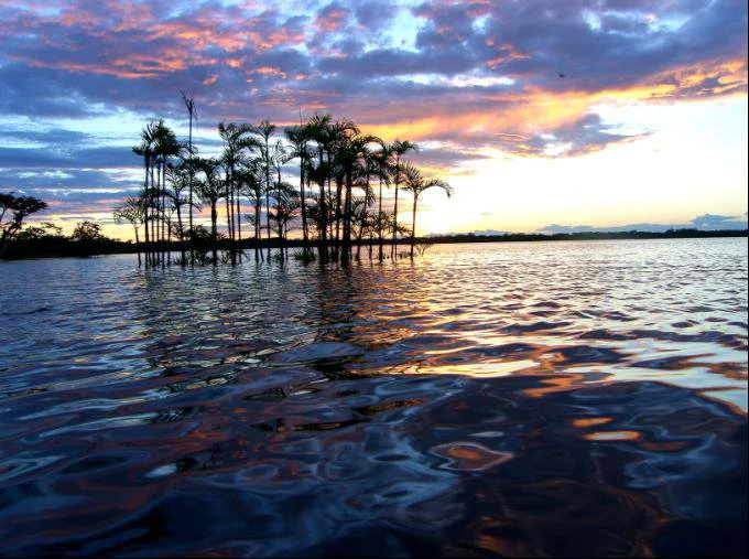
A tranquil sunset over a large, calm lake with silhouettes of tall palm trees rising directly out of the water.
Sunset over the waters of Laguna Grande in the Cuyabeno Wildlife Reserve.

Cuyabeno Fauna Production Reserve history and protected-area timeline

The Reserva de Producción de Fauna Cuyabeno was officially established on July 26, 1979, as part of Ecuador's effort to build a national system of natural protected areas, with technical groundwork provided by a 1976 FAO study. The original reserve covered roughly 155,000 hectares focused on the Cuyabeno river basin.

During the early 1980s, the construction of a new oil road and expanding petroleum activity brought an influx of colonists to the higher ground within the reserve, triggering widespread uncontrolled deforestation. In response, the reserve's director sought advisory support from the government of the Netherlands, which recommended expanding the protected area eastward to the border with Peru, ultimately enlarging Cuyabeno to roughly 600,000 hectares. The same advisors encouraged Ecuador to develop ecotourism to create alternative livelihoods and demonstrate the reserve's national importance.

Ecotourism effectively began in 1986 with a small group of sixteen visitors from the Netherlands, and in 1989 Neotropic Turis, formed specifically to support conservation through tourism, built Cuyabeno Lodge, the first ecological lodge inside the reserve. Working closely with indigenous communities, the company also launched the first guide-training programs. Over time, additional lodges such as Tapir Lodge and Guacamayo Ecolodge opened near Laguna Grande and downstream of it, and visitor numbers grew to around 12,000 per year, providing economic benefits to many Siona families. The reserve has since been modified administratively several times, with adjustments to its boundaries and regulations reflected in Ecuador's official registers during the 1990s.

Cuyabeno Fauna Production Reserve landscape and geographic character

The landscape of Cuyabeno is shaped by water. The reserve lies where the eastern foothills of the Andes give way abruptly to the Amazon lowlands, so the western edge still carries gently rolling terrain with low hills, but moving eastward the land flattens into broad, shallow floodplains crossed by rivers and studded with lagoons. From the bridge at the entrance on the Cuyabeno river, the hills quickly disappear and the terrain becomes a generally flat expanse of forest.

Two especially flat, low-lying floodplains define the hydrological character of the reserve. The first forms the system of interconnected lagoons around Laguna Grande, while the second lies along the Peruvian border. Beyond these floodplains the landscape continues as terra firme, low but well-drained terrain on very gentle uplands. The result is a mosaic of seasonally inundated forest, palm swamps, permanent and semi-permanent lakes, slow blackwater rivers such as the Cuyabeno itself, and sediment-rich whitewater rivers like the Aguarico, with the entire system pulsing seasonally between dry forests and vast submerged woodlands.
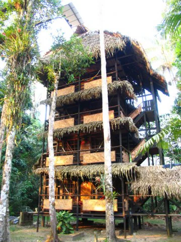
A tall wooden ecolodge building featuring several levels with thatched roofing and balconies, surrounded by dense tropical forest trees.
A multi-story ecolodge structure with a thatched roof situated within the rainforest of Cuyabeno Wildlife Production Reserve.

Cuyabeno Fauna Production Reserve ecosystems, habitats, and plant life

Cuyabeno lies entirely within the humid tropical forest belt of the western Amazon, a biome defined by high temperatures, very high rainfall, and consistently high humidity. The reserve's ecological interest comes not from a single habitat type but from the interplay between flooded and unflooded forest, between blackwater and whitewater river systems, and between permanently waterlogged swamps and terra firme soils.

The flooded ecosystems include the Mauritia flexuosa palm swamps, igapó forests darkened by tannin-rich blackwater rivers, and várzea forests enriched by the sediment-laden Aguarico. These inundated zones are relatively low in tree species diversity but are extraordinarily productive and important for fish, aquatic invertebrates, and the many animals that depend on seasonal flooding. The better-drained terra firme forests around them, by contrast, hold astonishing tree diversity at scales comparable to the richest sites on Earth.

Permanent lakes such as Zancudo Cocha and the semi-permanent Laguna Grande add another layer of ecological variety, with floating and emergent vegetation, shoreline Macrolobium trees draped in epiphytes, and seasonal exposures of lake bed that alter habitat availability year to year. Together these habitats produce the dense, layered tropical forest that defines Cuyabeno, where the canopy can close above broad stretches of stagnant, mirror-like water during the peak of the rainy season.

Cuyabeno Fauna Production Reserve wildlife and species highlights

Cuyabeno's wildlife profile is exceptionally broad thanks to its mosaic of habitats. All of the large Amazonian mammals are present, including the lowland tapir, two deer species, the full suite of Amazonian cats including jaguar and puma, both species of peccary, manatees, the giant otter, and two species of river dolphins, including the iconic pink dolphin. Ten monkey species are recorded, with the common squirrel monkey among the frequently observed primates, and the reserve is also rich in rodents and bats.

The birdlife is one of Cuyabeno's most celebrated features. Estimates of recorded bird species vary, with roughly 530 to over 580 species attributed to the reserve, including macaws, herons, and the strange Hoatzin, which nests in branches over the lagoons. Aquatic and semi-aquatic reptiles are abundant, with two caiman species, anacondas and other boas, numerous turtle species, and an overwhelming diversity of frogs and toads that chorus in the flooded forest during the rains.

Fish diversity is another major element, with around 350 species recorded. Many of these species follow the seasonal flooding into the inundated forest, where river dolphins have even been observed swimming among the trees in pursuit of prey. The combination of large mammals, primates, abundant reptiles, prolific birds, and rich fish faunas is what gives Cuyabeno its reputation as one of the most wildlife-rich protected areas in the Amazon.

Cuyabeno Fauna Production Reserve conservation status and protection priorities

Cuyabeno is part of Ecuador's national system of protected areas and is classified at the international level as an IUCN Category VI protected area, focused on the sustainable management of natural resources. Its conservation significance is principally tied to the protection of an enormous block of western Amazonian rainforest and its associated hydrological system, which together sustain some of the highest biodiversity levels on the planet.

The reserve was created in 1979 and later expanded precisely to prevent further uncontrolled deforestation driven by the construction of oil roads and the influx of colonists onto higher ground within the original boundaries. Expanding its footprint to the Peruvian border and developing ecotourism were both conservation strategies intended to give local communities, especially indigenous groups, a direct economic stake in protecting the forest.

Because flooding and terra firme forests generate very different levels of tree species diversity, protecting a representative mosaic of both habitats is essential to the reserve's long-term value. The presence of rare and emblematic species, including river dolphins, jaguar, manatee, tapir, and the Hoatzin, gives Cuyabeno particular weight in discussions of Amazonian conservation, while its sheer size and ecological complexity make it a critical refuge for a wide set of species whose survival increasingly depends on connected, intact rainforest.

Cuyabeno Fauna Production Reserve cultural meaning and human context

Cuyabeno is not only an ecological reserve but also a landscape inhabited and shaped by indigenous peoples. The Cofán and the Siona-Secoya communities live along the Aguarico and Cuyabeno rivers, with the Siona community traditionally established in the northern part of the reserve near Puerto Bolívar and along the Tarapuy river.

These communities are known not only for their presence in the rainforest but also for their tradition of shamanism. Siona, Secoya, and Cofán healers are respected throughout the broader Amazonian region for the depth of their medicinal and spiritual knowledge, which has been passed down over many generations. Their understanding of plants, animals, and forest cycles continues to inform local relationships with the landscape.

The reserve's ecotourism history is also a cultural one. From the construction of Cuyabeno Lodge onward, indigenous communities have been incorporated into both the building and operation of lodges and into specialized guide training. Today, ecotourism provides important economic support to many Siona families, and reserve management historically draws on partnerships between conservation authorities, specialized tourism operators, and these indigenous communities.

Top sights and standout views in Cuyabeno Fauna Production Reserve

Cuyabeno's most distinctive highlights are its vast flooded Amazonian forests and the lagoon system around Laguna Grande, where seasonally submerged woodlands, Macrolobium trees, and floating vegetation create one of the most photogenic and ecologically rich landscapes in Ecuador.

Equally important are the reserve's exceptional concentrations of wildlife, from the ten primate species and rich jaguar, tapir, and manatee populations to the over five hundred bird species and the approximately 350 fish species that move with the floodwaters. The presence of river dolphins, Hoatzins, caimans, and anacondas adds a strong sense of Amazonian character.

Finally, the cultural presence of the Cofán and Siona-Secoya communities, with their long traditions of forest knowledge and shamanism, combined with a pioneering community-influenced ecotourism model, makes Cuyabeno stand out as a reserve where biodiversity protection and indigenous heritage are closely intertwined.

Best time to visit Cuyabeno Fauna Production Reserve

Cuyabeno's seasonal cycle strongly shapes the experience of visiting. From December through March, a marked dry season reduces rainfall and exposes more land, making river and lagoon levels lower and forest trails more accessible, though wildlife is often more concentrated around remaining water bodies.

From April to July, the main rainy season brings extremely high precipitation and the annual flooding of vast forest areas, which produces the reserve's most iconic scenes of submerged forest, swimming dolphins, and abundant aquatic life. From August to November, rainfall moderates and the landscape gradually transitions, offering a balance between water levels, wildlife activity, and accessibility. Temperatures remain consistently warm throughout the year, and the high humidity and tropical climate always define the atmosphere of any visit.

Monthly climate preview

Long-term temperature ranges and monthly precipitation metrics for protected regional terrain

Reserva de Producción de Fauna Cuyabeno Climate Normals and Annual Weather Patterns

Measured NASA Power coordinates reveal steady thermal baselines alongside distinct monthly precipitation variations across the protected landscape. Examining the full twelve-month profile provides complete historical averages for temperature and rainfall rhythms.
Annual mean25 °C
24 °C25 °C
Jan25°
Feb25°
Mar25°
Apr25°
May25°
Jun24°
Jul24°
Aug25°
Sep25°
Oct25°
Nov25°
Dec25°
Warmest month
February

25.4 °C

Coolest month
July

24 °C

Wettest month
May

8.6 mm/day

Driest month
January

4.2 mm/day

Park location guide

Geography guide, regional context, and park location map for Cuyabeno Fauna Production Reserve

Cuyabeno Fauna Production Reserve park geography, regions, and map view in Ecuador

Understand where Cuyabeno Fauna Production Reserve sits in Ecuador through a broader geographic reading of the surrounding landscape, nearby location context, and its mapped position within the national park landscape.

How Cuyabeno Fauna Production Reserve fits into Ecuador

Ecuador is a presidential republic located in northwestern South America, with Quito as its capital and Guayaquil as its largest city. The country spans 283,561 km² and encompasses the Galápagos Islands, a volcanic archipelago famous for unique wildlife that helped shape Darwin's theory of evolution. Ecuador is a plurinational state with Spanish as the official language, though Kichwa and Shuar are recognized for indigenous peoples.

Wider geography shaping Cuyabeno Fauna Production Reserve in Ecuador

Ecuador is located in northwestern South America along the Pacific coast. It shares borders with Colombia to the north and Peru to the east and south. The country includes the Galápagos Islands, a volcanic archipelago in the Pacific Ocean approximately 1,000 km west of the mainland. The territory encompasses diverse terrain including the Amazon rainforest in the east, the Andean highlands in the center, and coastal plains along the Pacific.

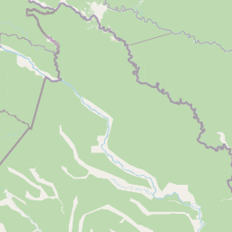
Map view of Cuyabeno Fauna Production Reserve

Use this park location map to pinpoint Cuyabeno Fauna Production Reserve in Ecuador, understand its exact geographic position, and read its mapped placement within the surrounding landscape more clearly.

Pigeon | © OpenStreetMap contributors

Location context for Cuyabeno Fauna Production Reserve

OrellanaSucumbíos
Recorded earthquake history

Explore Recorded Seismic History for Reserva de Producción de Fauna Cuyabeno

Review documented seismic events associated with the Reserva de Producción de Fauna Cuyabeno by distance. This MoriAtlas catalogue provides historical access to recorded magnitudes, depths, and epicentre coordinates to support geographic inquiry into the region surrounding this Amazonian reserve.

Cuyabeno Earthquake History

Catalogued events

1 event

Strongest magnitude

Magnitude 4

Most recent event

Apr 29, 2016

This history includes earthquakes recorded inside the park or within 50 km of its borders

Visualizing flooded Amazonian forest habitats and river scenery

Reserva de Producción de Fauna Cuyabeno Photos and Landscapes

Visual records capture the flooded forest terrain, blackwater river networks, and lagoon systems defining Reserva de Producción de Fauna Cuyabeno. Examining these protected area photographs reveals the complex seasonal habitats and lowland Amazonian geography supporting the reserve.

A tranquil sunset over a large, calm lake with silhouettes of tall palm trees rising directly out of the water.

A squirrel monkey with characteristic white facial markings standing on a thin tree branch in a dense green forest.

A tall wooden ecolodge building featuring several levels with thatched roofing and balconies, surrounded by dense tropical forest trees.

Park atlas

Compare surrounding lowland forests and regional Amazonian conservation zones

Explore Protected Areas and Parks Near Reserva de Producción de Fauna Cuyabeno

Browsing nearby national parks allows visitors to evaluate adjacent lowland tropical forests and regional river basins. Comparing protected areas across the surrounding landscape reveals broader ecological connections and diverse wetland geography.
Wildlife reserveLoreto Region
Park boundaries overlap#1 closest

Southeast

Airo Pai Communal Reserve: Protected Wildlife and Amazonian Landscapes in Loreto, Peru

Analyzing the geographic character of this communal wildlife reserve

Airo Pai Communal Reserve serves as a pillar of conservation in the Loreto Region of northern Peru. This wildlife reserve features a complex hydrological mosaic of upland forest, palm-dominated swamps, and periodically flooded lowlands. By protecting these vital ecosystems, the reserve ensures the continuity of both indigenous cultural heritage and the habitats of iconic Amazonian aquatic species.

Area
2,478.88 km²
Established
2012
IUCN
VI
Relief
Lowland
National parkPeru
Park boundaries overlap#2 closest

East

Güeppi-Sekime National Park: Protected National Park Atlas in Peru

Mapped landscape and regional geography of this Amazonian protected area.

Güeppi-Sekime National Park is a prominent protected area in Peru, recognized as a national park safeguarding a substantial expanse of tropical forest. Its landscape is characterized by diverse terrain, including rolling hills and seasonally inundated lowlands, vital for a rich tapestry of flora and fauna. The park's strategic location on the Ecuador border underscores its importance for transboundary conservation and ecological connectivity within the western Amazon basin. This page offers detailed information on its protected area identity, geographic context, and the mapped natural features that define this significant conservation landscape.

Area
2,036 km²
Established
2012
IUCN
II
Relief
Mixed relief
National parkEcuador
11 km away#3 closest

South

Yasuní National Park: Ecuador's Protected Landscape and Geographic Atlas Entry

Explore the mapped boundaries and regional terrain of this key national park.

Delve into the atlas-level details of Yasuní National Park, Ecuador's designated national park. This entry provides essential geographic context, focusing on the park's mapped boundaries and its role as a protected landscape within the region. Understand the specific terrain and protected area distribution that makes Yasuní National Park a significant point of geographic interest for atlas exploration.

Area
10,227.4 km²
Established
1979
IUCN
II
Relief
Lowland
Wildlife reserveLoreto Region
28 km away#4 closest

East

Huimeki Communal Reserve: Amazonian Geography and Protected Forest Atlas

Key wildlife reserve located in the Loreto Region, Peru

Huimeki Communal Reserve stands as a sentinel of the Putumayo basin, protecting vital lowland Amazonian environments. This reserve serves as a crucial link in a wider ecological corridor, preserving habitats that are restricted to this remote northeastern frontier of the Peruvian landscape.

Area
1,412.34 km²
Established
2012
IUCN
VI
Relief
Lowland
Wildlife reserveSucumbíos
29 km away#5 closest

West

Reserva Biológica Limoncocha: Geography, Wetland Ecosystems, and Protected Boundaries

A vital Amazonian wildlife reserve in the Sucumbíos province.

Reserva Biológica Limoncocha is a distinctive wetland reserve defined by its intricate system of lagoons, rivers, and seasonal floodplains. Its geography provides a rare look at Amazonian biodiversity, ranging from elevated forest plateaus to permanently inundated palm swamps and vital black caiman habitats.

Area
46.13 km²
Established
1985
IUCN
VI
Relief
Lowland
Nature reserveSucumbíos
66 km away#6 closest

West

Reserva Ecológica Cofán-Bermejo: Mapping Amazonian and Andean Biodiversity Landscapes

Indigenous-led conservation in the Sucumbíos river headwaters.

Reserva Ecológica Cofán-Bermejo encompasses a remarkable altitudinal range from 400 to 2,200 meters, protecting intact river basins and transitional ecosystems. This nature reserve offers deep insight into the convergence of Amazonian and Andean flora, functioning as a vital refuge for threatened megafauna and rare bird populations within an indigenous-managed territory.

Area
549.47 km²
Established
2002
IUCN
Ia
Relief
Mountain
National parkEcuador
75 km away#7 closest

West

Sumaco Napo-Galeras National Park: Ecuador's Volcanic National Park Landscape

Explore protected areas and biodiversity in the Andean-Amazon transition.

Sumaco Napo-Galeras National Park protects a dramatic volcanic landscape in Ecuador, showcasing a significant elevation gradient that supports diverse cloud forest and Amazonian rainforest habitats. This national park is recognized for its endemic species and rich avifauna, offering a compelling case study for understanding protected land geography and ecological transitions within South America.

Area
2,067.49 km²
Established
1994
IUCN
II
Relief
Mountain
Protected areaColombia
About 87 km away#8 closest

Northwest

Santuario Orito Indí-Andé Fauna and Flora Sanctuary: A Protected Area's Geographic and Landscape Identity in Colombia

Explore mapped boundaries and regional natural terrain context.

Gain insight into Santuario Orito Indí-Andé Fauna and Flora Sanctuary, a vital protected area contributing to Colombia's conservation landscape. This entry focuses on its distinct geographic characteristics and mapped territory. Understand the park's place within the national atlas and its contribution to regional geographic knowledge. It provides a structured foundation for exploring the natural terrain and protected boundaries specific to this important Colombian sanctuary.

Area
1,020 km²
Established
2008
Relief
Mountain
Access
Access unknown

Common questions about visiting, size, designation, and location context for Cuyabeno Fauna Production Reserve

Cuyabeno Fauna Production Reserve FAQs for park facts, access, geography, and protected area context

Find quick answers about Cuyabeno Fauna Production Reserve, including protected-area facts, park geography, trail and visitor context, and how the park fits into its surrounding country and regional landscape.
MoriAtlas Explorer

Continue Your Protected Areas Search Across the Global Atlas

Deepen your exploration by continuing the structured search for national parks and protected areas worldwide. Utilize the comprehensive filtering capabilities to compare different conservation landscapes and refine your understanding of global park geography. Discover more about the distribution and characteristics of protected natural areas.

Global natural geography
