Mori Atlas logo
Nature reserveRéserve naturelle nationale géologique du Luberon

A comprehensive atlas overview of protected paleontological sites, fossil trackways, and limestone formations in southeastern France

Réserve naturelle nationale géologique du Luberon: Geological Heritage and Mapped Provençal Landscapes

(Réserve naturelle nationale géologique du Luberon (RNN 90))

The Réserve naturelle nationale géologique du Luberon preserves a network of 28 critical paleontological and geological sites across the Provence-Alpes-Côte d'Azur region. Spanning millions of years of Cenozoic history, the protected zones document unique fossil-bearing rock formations, ancient mammal footprint surfaces, and sedimentary layers. This atlas entry provides a detailed look at the geographic distribution of these sites within the broader Luberon massif.

national nature reservegeological heritagepaleontologyfossil sitesCenozoicmammal trackways

Réserve naturelle nationale géologique du Luberon

Nature reserve

Park overview

Structured park overview, official facts, and landscape profile for Réserve naturelle nationale géologique du Luberon

Réserve naturelle nationale géologique du Luberon park facts, protected area profile, and essential visitor context

Review the core facts for Réserve naturelle nationale géologique du Luberon, including designation, size, terrain, visitor scale, habitats, and operating context in one park-focused overview.

About Réserve naturelle nationale géologique du Luberon

The Réserve naturelle nationale géologique du Luberon is one of the rare national natural reserves in France whose primary purpose is to protect geological heritage rather than living ecosystems. Located in the heart of Provence, it gathers together a series of fossil-rich outcrops and sedimentary exposures that together tell a deep-time story of the southeastern French landscape.

Spread across the départements of Alpes-de-Haute-Provence and Vaucluse, the reserve is not a single contiguous block of land. Instead, it is composed of dozens of individual sites dispersed through roughly twenty communes, including villages such as Céreste, Aubenas-les-Alpes, Reillanne, Oppedette, Bonnieux, Cucuron, and Saignon. This scattered configuration reflects the practical reality of preserving small but scientifically significant outcrops within a working cultural landscape of vineyards, lavender fields, orchards, and hilltop settlements.

The reserve's defining mission is to safeguard 28 geological localities that together preserve evidence of past life and environments from the Tertiary, more formally known today as the Cenozoic. The sites have been grouped into four main categories: Oligocene deposits containing fossil vertebrates, insects, and plants; Oligocene surfaces preserving mammal footprints; Eocene and Miocene vertebrate fossil sites; and Miocene and Pliocene invertebrate fossil localities. Together, they offer researchers a richly documented cross-section of the changing climates, ecosystems, and faunas of the region across many millions of years.

Administratively, the reserve is managed by the Parc naturel régional du Luberon, which also supervises a surrounding protection zone of roughly 70,000 hectares designated by prefectoral order to shield the geological sites from incompatible land use. This integration with the regional park allows the geological reserve to benefit from a broader territorial management framework while preserving its national-level protection status.

Quick facts and research context for Réserve naturelle nationale géologique du Luberon

The reserve was established by decree on 16 September 1987 and is classified as a national nature reserve, or Réserve naturelle nationale, under French law. Its code, RNN 90, places it among the long-running series of national nature reserves in France.

It covers a footprint of roughly 300 hectares of protected land area, supplemented by a much larger surrounding buffer of around 70,000 hectares established by prefectoral order. The reserve lies entirely within the region of Provence-Alpes-Côte d'Azur and is administered through the wider Parc naturel régional du Luberon. UNESCO has recognised the geological interest of the broader Luberon area through its Regional Nature Park geotourism programme.

Protection and recognition

Documented conservation records, management scope, and protected area designation details

Protection Status and International Recognition for Réserve naturelle nationale géologique du Luberon

Examination of Réserve naturelle nationale géologique du Luberon reveals documented protection status and official database records. Systematic review of protected area data provides verified baseline metrics for conservation management analysis.

Protection details

WDPA ID
106719
Park context

Deeper park guide and search-rich context for Réserve naturelle nationale géologique du Luberon

Réserve naturelle nationale géologique du Luberon history, landscape, wildlife, and travel context

Explore Réserve naturelle nationale géologique du Luberon through its history, landscape character, ecosystems, wildlife, conservation priorities, cultural context, and seasonal travel timing in a structured park guide built for atlas discovery and search intent.

Why Réserve naturelle nationale géologique du Luberon stands out

The reserve is best known for its network of 28 protected paleontological and geological sites documenting the Cenozoic Era, including Oligocene, Eocene, Miocene, and Pliocene localities of regional and international scientific importance. It is also recognised for its remarkable fossil trackways, particularly ancient mammal footprint surfaces in laminated lake sediments that preserve traces of Oligocene animals. These trace fossils, together with vertebrate, insect, and plant fossil-bearing sites, give the Luberon a distinctive place in European paleontology and make the reserve a frequent destination for scientific fieldwork and guided geological visits.

Réserve naturelle nationale géologique du Luberon history and protected-area timeline

The Réserve naturelle nationale géologique du Luberon was formally established by ministerial decree on 16 September 1987, placing it among the earliest generation of French national nature reserves dedicated specifically to geological heritage. Its creation reflected a growing recognition that France's national reserve system needed to address not only ecological values but also the country's rich and globally significant fossil record.

The choice of the Luberon was driven by the area's long history of paleontological research and the exceptional density of fossil-bearing localities across a relatively small geographic area. Throughout the twentieth century, geologists and paleontologists had documented significant vertebrate, invertebrate, and trace fossil sites scattered across the region's limestone terrain. When national-status protection became available, the Luberon offered a coherent set of scientifically important localities in a single territorial setting, making it a natural candidate for France's system of réserves naturelles nationales.

Following its designation, the reserve was placed under the management of the then-developing Parc naturel régional du Luberon. This administrative arrangement allowed the geological reserve to draw on the regional park's broader territorial presence, local partnerships, and conservation resources while maintaining its distinct national stature. Together with the surrounding prefectoral protection zone, the reserve has since functioned as a protected geological network embedded within a working agricultural and tourist landscape.

Réserve naturelle nationale géologique du Luberon landscape and geographic character

The reserve sits within the landscape of the Luberon massif, a chain of hills and plateaus in Provence characterised by alternating limestone ridges, soft marl basins, and deeply cut valleys. The region is shaped by Mediterranean climate conditions and centuries of human activity, producing a mosaic of cultivated fields, scrubland, oak woodland, pine forest, vineyard terraces, and perched villages.

The protected geological sites are not concentrated in a single dramatic landscape but rather scattered through these varied terrains. Some outcrops lie along road cuts and riverbanks where erosion has exposed fossil-rich layers, while others are found in working quarries, on hill flanks, or within the weathered surfaces of uplifted sedimentary formations. The underlying geology ranges from lacustrine and lagoonal deposits to marine sediments, reflecting a long history of changing environments as the region transitioned from a tectonically active margin to the more stable Provençal carbonate platform seen today.

Surface exposures of particular importance include laminated limestone and marl slabs that preserve delicate trace fossils, as well as harder limestone formations rich in vertebrate remains. The broader Luberon scenery, with its pale cliffs, dry valleys, and wide views across vineyards and olive groves, frames the scientific sites and gives the reserve a distinctly Provençal geographic character.

Réserve naturelle nationale géologique du Luberon ecosystems, habitats, and plant life

Although the Luberon geological reserve is defined by its paleontological mission rather than by living-habitat protection, it lies within one of the most ecologically distinctive regions of Mediterranean France. The surrounding landscape supports a rich variety of Provençal habitats, including garrigue scrub, mixed holm oak and pubescent oak woodland, Aleppo pine stands, cultivated terraces, and seasonal stream corridors.

This mosaic of environments produces the floral and faunal diversity typical of inland Provence, with aromatic plants such as rosemary, thyme, and lavender, as well as chestnut and olive groves on suitable slopes. The geological sites themselves are often modest in surface area, but their integration into the regional park's broader territory means they sit within a landscape whose biodiversity is shaped by traditional land management practices, climate, and topography.

The reserve's ecological role is therefore indirect but real: by protecting discrete, sensitive sites from destructive activities within a broader mosaic that includes agricultural land, it ensures that key geological exposures remain intact for future research while the surrounding habitats continue to function under the regional park's wider stewardship.

Réserve naturelle nationale géologique du Luberon wildlife and species highlights

The Réserve naturelle nationale géologique du Luberon does not protect wildlife as its primary mission, and so it does not maintain an inventory of living fauna in the way an ecological reserve might. Its scientific interest lies instead in ancient life, preserved as fossils and trace fossils within sedimentary rocks.

Among the most remarkable paleontological records of the reserve are fossil trackways attributed to Oligocene mammals, preserved on ancient lake-bottom surfaces that have since lithified into stone. These trace fossils provide direct evidence of the gait, behaviour, and ecological context of mammals that lived in the region tens of millions of years ago, and they have become one of the reserve's most celebrated scientific features.

The broader vertebrate fossil sites include Eocene and Miocene localities that have yielded significant mammal, reptile, and other vertebrate remains, while Miocene and Pliocene invertebrate sites document the changing marine and freshwater communities of the region. Insect and plant fossil localities further enrich the faunal and floral picture of past ecosystems, giving the reserve an unusually broad paleontological profile for a protected area of its size.

Réserve naturelle nationale géologique du Luberon conservation status and protection priorities

The reserve represents a particular form of conservation focused on geological and paleontological heritage, an important but often underrepresented category within protected-area networks. By placing individual fossil sites under national protection, it ensures that scientifically important exposures cannot be destroyed or degraded by quarrying, development, or uncontrolled collecting.

A core element of the reserve's conservation strategy is its four-category organisation of protected sites: Oligocene vertebrate, insect, and plant fossil sites; Oligocene mammal footprint sites; Eocene and Miocene vertebrate sites; and Miocene and Pliocene invertebrate sites. This categorisation allows targeted protection of the features of highest scientific value while accommodating continued land use around each site.

A surrounding prefectoral protection zone of approximately 70,000 hectares reinforces the reserve's effectiveness by regulating activities in the broader landscape that could affect the integrity of geological exposures. Managed jointly with the Parc naturel régional du Luberon, the reserve contributes to international recognition of the Luberon as a UNESCO-supported geotourism destination and serves as a reference site for geological heritage protection in France.

Réserve naturelle nationale géologique du Luberon cultural meaning and human context

The reserve is deeply embedded in the cultural landscape of the Luberon, a region long associated with the image of inland Provence through its hilltop villages, vineyards, lavender fields, and olive groves. The communes that host protected geological sites, including Céreste, Cucuron, Bonnieux, and Saignon, are themselves part of the broader Provençal heritage of rural settlement and traditional land management.

The relationship between stone, soil, and human history runs through the region. Local building traditions have long relied on the same limestone formations that contain the fossils now under protection, while agriculture has shaped and been shaped by the underlying geological substrates. The reserve's creation and its subsequent integration with the regional park reflect a wider Provençal tradition of valuing natural and cultural landscapes together, linking modern conservation to centuries of rural life.

Educational and guided-visit programmes connected to the reserve further tie its scientific role to the cultural identity of the territory, offering visitors a way to engage with deep geological time within a working Provençal countryside.

Top sights and standout views in Réserve naturelle nationale géologique du Luberon

The reserve's standout features include its 28 formally protected geological sites spanning the Cenozoic Era, from the Eocene through the Pliocene. Among them, the Oligocene mammal footprint surfaces are particularly notable for their scientific and interpretive value, capturing moments of ancient animal behaviour preserved in stone.

The reserve's location within the Parc naturel régional du Luberon and its UNESCO-recognised geotourism setting place it in a globally visible network of geological heritage sites. Its dispersed configuration across about twenty communes, combined with a large surrounding protection zone, gives it both scientific depth and territorial significance uncommon for a national nature reserve of its size.

Best time to visit Réserve naturelle nationale géologique du Luberon

Spring and early autumn are typically the most rewarding seasons to explore the Luberon geological sites, when the Provençal climate is mild, vegetation is not at its most parched, and field conditions are comfortable for walking between scattered outcrops. These seasons also align with the rhythms of regional tourism, when guided geological activities and cultural events in the surrounding villages are most active.

Summer brings high heat and the dry, golden character of the Provençal landscape, which can make longer exploration uncomfortable despite the clarity of the light and wide open views. Winter is generally quiet, with cooler temperatures and occasional snow on the highest parts of the Luberon. Visitors interested in particular paleontological sites or guided visits are best served by checking with the regional park for current information before travelling.
Monthly climate preview

Long-term representative monthly temperature and precipitation rhythm across the park coordinate

Climate Normals and Temperature Patterns for Réserve naturelle nationale géologique du Luberon

Representative coordinate measurements track long-term average temperature ranges from sub-zero winter minimums to warm summer maximums alongside measured precipitation rates. Reviewing the complete twelve-month dataset clarifies the full annual climate rhythm at this recorded elevation.
Annual mean11 °C
2 °C22 °C
Jan
Feb
Mar
Apr10°
May14°
Jun19°
Jul22°
Aug22°
Sep17°
Oct12°
Nov
Dec
Warmest month
July

22.2 °C

Coolest month
January

2.5 °C

Wettest month
November

3 mm/day

Driest month
July

0.8 mm/day

Park location guide

Geography guide, regional context, and park location map for Réserve naturelle nationale géologique du Luberon

Réserve naturelle nationale géologique du Luberon park geography, regions, and map view in France

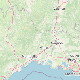
Understand where Réserve naturelle nationale géologique du Luberon sits in France through a broader geographic reading of the surrounding landscape, nearby location context, and its mapped position within the national park landscape.

How Réserve naturelle nationale géologique du Luberon fits into France

France is a unitary semi-presidential republic and one of the world's largest economies. It borders Belgium, Luxembourg, Germany, Switzerland, Italy, Monaco, Andorra, and Spain, with a maritime border to the United Kingdom. The country is known for its cultural influence, art, cuisine, and political history spanning centuries.

Wider geography shaping Réserve naturelle nationale géologique du Luberon in France

France is located in Western Europe. Metropolitan France extends from the Rhine to the Atlantic Ocean and from the Mediterranean Sea to the English Channel and North Sea. The country borders Belgium, Luxembourg, Germany, Switzerland, Italy, Monaco, Andorra, Spain, and has a maritime border with the United Kingdom.

Map view of Réserve naturelle nationale géologique du Luberon

Use this park location map to pinpoint Réserve naturelle nationale géologique du Luberon in France, understand its exact geographic position, and read its mapped placement within the surrounding landscape more clearly.

Pigeon | © OpenStreetMap contributors

Location context for Réserve naturelle nationale géologique du Luberon

Provence-Alpes-Côte d'Azur
Park atlas

Compare surrounding limestone ridges, fossil sites, and protected Mediterranean landscapes.

Parks Near Réserve Naturelle Nationale Géologique Du Luberon And Regional Protected Areas

Browsing other protected areas near Réserve naturelle nationale géologique du Luberon reveals the broader geological and ecological patterns of southeastern France. Examining adjacent regional landscapes helps connect scattered fossil localities to the wider terrain of Provence and the Mediterranean basin.
A soft watercolor illustration depicting layered rolling hills, distant mountain silhouettes, and clusters of trees in a pale color palette.
Regional parkProvence-Alpes-Côte d'Azur
About 0.4 km away#1 closest

Northwest

Parc naturel régional du Luberon: Regional Park Boundaries and Protected Landscape Atlas

Geology, mountain ridges, and Mediterranean ecosystems of Provence

Parc naturel régional du Luberon serves as a vital protected corridor in southeastern France. The park features three parallel limestone massifs, dramatic ochre formations, and fossil-rich plateaus. Its geography offers a case study in integrating sustainable land use with rich biodiversity across the Vaucluse and Alpes-de-Haute-Provence departments.

Area
1,747.26 km²
Established
1977
IUCN
V
Visitors
350K annual
Nature reserveProvence-Alpes-Côte d'Azur
About 30 km away#2 closest

Northwest

Réserve naturelle régionale Ermitage-Escampeaux: A Protected Landscape in the Vaucluse Department

Mapping regional nature reserves within inland Provence-Alpes-Côte d'Azur.

Located in the Villes-sur-Auzon commune, the Réserve naturelle régionale Ermitage-Escampeaux stands as a significant addition to the protected lands of Provence-Alpes-Côte d'Azur. This 252.9-hectare reserve offers a focused look at the transition between Mediterranean garrigue and the higher Provençal uplands, providing essential habitat conservation within a traditional rural mosaic.

Area
2.529 km²
Established
2026
IUCN
IV
Nature reserveProvence-Alpes-Côte d'Azur
About 45 km away#3 closest

Southwest

Réserve naturelle régionale de la Poitevine-Regarde-Venir: Steppe Conservation and Geography

Protected dry steppe landscapes in the French Crau region

Delve into the geography of the Réserve naturelle régionale de la Poitevine-Regarde-Venir, a specialized nature reserve that safeguards the distinctive pebbly coussoul of the Crau plain. The area represents a fundamental piece of Mediterranean pastoral history, balancing fragile steppe ecosystems with traditional agricultural meadows.

Area
2.207 km²
Established
2009
IUCN
IV
Nature reserveProvence-Alpes-Côte d'Azur
About 59 km away#4 closest

Southwest

Réserve naturelle régionale du Pourra - Domaine du Ranquet: Coastal Lagoon Protected Landscape

Regional Nature Reserve in Provence-Alpes-Côte d'Azur

Spanning over 300 hectares near Port-de-Bouc, this protected area preserves interconnected Mediterranean lagoons and surrounding marshlands. It offers a distinct geographic perspective on transitional coastal habitats situated within the heavily developed Bouches-du-Rhône department.

Area
3.153 km²
Established
2020
IUCN
IV
A horizontal watercolor painting depicting a soft-focus landscape of grassy wetlands in the foreground with gentle, rolling hills in the background.
Nature reserveProvence-Alpes-Côte d'Azur
About 61 km away#5 closest

West

Réserve naturelle régionale de l'Ilon: Protected Wetland Atlas and Geographic Context

Mapping Mediterranean marshes in the Alpilles foothills.

Covering 176 hectares of diverse wetland habitat, Réserve naturelle régionale de l'Ilon preserves critical marshlands and floodable meadows. This site demonstrates the interplay between lowland water systems and the rocky Alpilles range, providing a essential refuge for diverse dragonfly and bird species within the heart of Provence.

Area
1.76 km²
Established
2012
IUCN
IV
Nature reserveProvence-Alpes-Côte d'Azur
About 62 km away#6 closest

East

Réserve naturelle régionale de Saint-Maurin: Geological Heritage in the Verdon Gorge

Travertine formations and cave habitats in Provence

Covering 25 hectares at the mouth of the Gorges du Verdon, this regional nature reserve protects a rare set of travertine terraces and tufa caves. Its geography creates a micro-refuge for specific cave-dwelling species and cliff-nesting raptors, standing as a significant example of geological and biological preservation in the Alpes-de-Haute-Provence department.

Area
0.248 km²
Established
2009
IUCN
IV
Relief
Upland
Watercolor illustration of coastal mountains and shoreline with scattered trees
National parkBouches-du-Rhône
About 62 km away#7 closest

South

Calanques National Park: Mediterranean Limestone Cliffs and Marine Protected Area

France's First Peri-Urban National Park

Calanques National Park, situated in the Bouches-du-Rhône department, represents a significant protected landscape where dramatic limestone geology meets the Mediterranean Sea. This atlas-focused entry details the park's iconic calanques, its combined terrestrial and marine protected zones, and its rich prehistoric cultural significance. Understand its unique geographic setting and its importance as a conservation area accessible for map-based discovery and regional landscape context.

Area
520 km²
Established
2012
IUCN
II
Relief
Mountain
A horizontal watercolor illustration showing a marshy, grassy landscape with soft green and muted pink tones against a white background.
Regional parkProvence-Alpes-Côte d'Azur
About 65 km away#8 closest

West

Parc naturel régional de Camargue: Mapping the Rhône Delta Protected Wetland Landscape

Regional park geography and wetland conservation zones

Parc naturel régional de Camargue is a sprawling protected landscape at the confluence of the Rhône and the Mediterranean. This regional park contains significant saline lagoons, coastal dunes, and fertile marshes that serve as a crucial site for waterbird migration. Understand the interplay between traditional salt-making, pastoral ranching, and the strictly protected nature reserves that shape this delta territory.

Area
856.9 km²
Established
1970
IUCN
V
Relief
Lowland

Common questions about visiting, size, designation, and location context for Réserve naturelle nationale géologique du Luberon

Réserve naturelle nationale géologique du Luberon FAQs for park facts, access, geography, and protected area context

Find quick answers about Réserve naturelle nationale géologique du Luberon, including protected-area facts, park geography, trail and visitor context, and how the park fits into its surrounding country and regional landscape.
MoriAtlas Explorer

Continue Your Protected Areas Search Across the Global Atlas

Deepen your exploration by continuing the structured search for national parks and protected areas worldwide. Utilize the comprehensive filtering capabilities to compare different conservation landscapes and refine your understanding of global park geography. Discover more about the distribution and characteristics of protected natural areas.

Global natural geography