
Mori Atlas logo
Nature reserveRéserve naturelle régionale de la côte de la Fontaine

A rare calcareous grassland habitat overlooking the meanders of the Seine River Valley

Réserve naturelle régionale de la côte de la Fontaine: Protected Chalk Coteau in Normandie

The Réserve naturelle régionale de la côte de la Fontaine protects 12 hectares of southwest-facing limestone slopes and chalk coteau within the Seine-Maritime department of Normandie. This vital nature reserve features steep terrain descending from a plateau to the riverside, hosting a dense concentration of rare plants, insects, and bird species. Visitors and researchers use this map-based atlas to trace the boundaries of these protected grasslands and understand their conservation value within the larger Seine valley landscape.

regional nature reservechalk coteaucalcareous grasslandSeine valleyNormandySeine-Maritime
A digital illustration of a wide river valley with steep hillsides and forest on the banks, set under a sun in a soft, light-toned color palette.

Réserve naturelle régionale de la côte de la Fontaine

Nature reserve

Park overview

Structured park overview, official facts, and landscape profile for Réserve naturelle régionale de la côte de la Fontaine

Réserve naturelle régionale de la côte de la Fontaine park facts, protected area profile, and essential visitor context

Review the core facts for Réserve naturelle régionale de la côte de la Fontaine, including designation, size, terrain, visitor scale, habitats, and operating context in one park-focused overview.

About Réserve naturelle régionale de la côte de la Fontaine

The Réserve naturelle régionale de la côte de la Fontaine is a French regional nature reserve that protects a short but ecologically important chalk slope in the lower Seine valley. Although the site covers only about 12 hectares, it concentrates a remarkable diversity of habitats typical of limestone slopes, from open short grasslands and scrubby fringes to denser woodland, all set against a dramatic river panorama.

Located on the commune of Hénouville in Seine-Maritime, the reserve occupies a southwest-facing coteau that drops from a clay-with-flints plateau down toward a wide bend of the Seine. Its elevation range, from roughly 10 meters above the river to about 90 meters on the upper slopes, produces a range of microclimates that support different plant communities. Lower down, the cooler and more humid conditions near the river allow moisture-loving species such as the common adder's-tongue fern to persist, while the dry, sunny mid-slope supports a classic calcareous grassland flora.

The reserve sits within the Parc naturel régional des Boucles de la Seine normande, a larger regional park that aims to protect and manage the landscape of the meandering lower Seine. This broader setting gives the small reserve greater ecological context, linking its chalk slope habitats to the river valley's mosaic of woodlands, meadows, and cliffs. The site is also part of several overlapping conservation designations, including a Special Protection Zone for the lower Seine meanders and a ZNIEFF (Zones Naturelles d'Intérêt Écologique, Faunistique et Floristique, meaning natural areas of ecological, faunistic, and floristic interest) type I inventory for the coteaux of Hénouville.

Open to the public under the reserve's regulations, the côte de la Fontaine offers both a window into a rare regional habitat and a sweeping viewpoint over one of Normandy's most characteristic river landscapes. Its combination of scientific interest, scenic value, and accessibility makes it a particularly representative example of the small but ecologically rich regional nature reserves of northern France.

Quick facts and research context for Réserve naturelle régionale de la côte de la Fontaine

The Réserve naturelle régionale de la côte de la Fontaine covers a compact area of approximately 12 hectares on a southwest-facing chalk slope. It is located in the commune of Hénouville, in the Seine-Maritime department of Normandy, on the edge of a broad meander of the Seine River between roughly 10 and 90 meters of elevation.

The reserve is administered under the French regional nature reserve system and was reclassified in 2015 after an initial voluntary nature reserve designation in 1998. It lies within the Parc naturel régional des Boucles de la Seine normande and overlaps with several other protection designations, including a Special Protection Zone, a ZNIEFF type I inventory for the coteaux of Hénouville, and a classified site covering the Boucle de Roumare.

Protection and recognition

Review the official terrestrial protection scope and documented designation records.

Réserve naturelle régionale de la côte de la Fontaine Protection Status and Designation History

Comprehensive protected area records outline the established designation history and terrestrial management scope for Réserve naturelle régionale de la côte de la Fontaine. Structured conservation data details the official protection status and baseline international recognition parameters.

Protection details

Protection scope
Terrestrial
Designated year
2015
Transboundary protection
No
WDPA ID
555597231
Park context

Deeper park guide and search-rich context for Réserve naturelle régionale de la côte de la Fontaine

Réserve naturelle régionale de la côte de la Fontaine history, landscape, wildlife, and travel context

Explore Réserve naturelle régionale de la côte de la Fontaine through its history, landscape character, ecosystems, wildlife, conservation priorities, cultural context, and seasonal travel timing in a structured park guide built for atlas discovery and search intent.

Why Réserve naturelle régionale de la côte de la Fontaine stands out

The reserve is best known for its chalk coteau, a south-west-facing calcareous slope that rises above a meander of the Seine. This kind of limestone slope habitat hosts a distinctive open plant community of short calcareous grasslands, sometimes called pelouses calcicoles, which are rare and considered heritage habitats at the regional level. The combination of open calcareous grassland, wooded fringes, and a position overlooking the Seine valley gives the site its strong identity. It is also notable for the conservation value of its flora and fauna. Inventories on the site have recorded more than 500 taxa, including several regionally rare plant species and a number of protected insect and bird species. The site therefore functions as a small but biologically rich refuge for calcareous slope specialists in an otherwise heavily cultivated landscape.
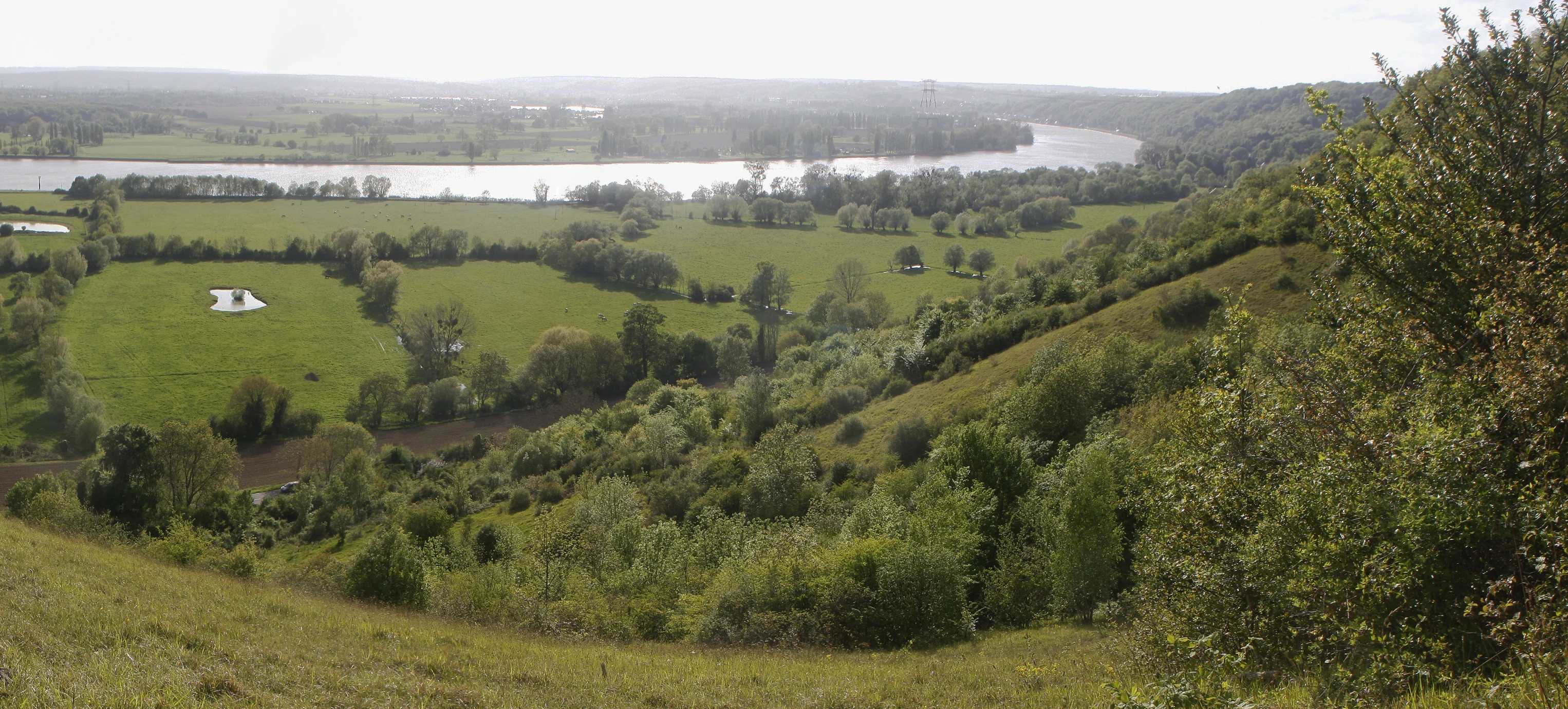
A wide landscape view from a high vantage point overlooking the Seine River valley with green pastures, wooded areas, and a river bend.
A view overlooking the Seine river from the slopes of the Côte de la Fontaine.

Réserve naturelle régionale de la côte de la Fontaine history and protected-area timeline

The history of the côte de la Fontaine reflects the broader evolution of human land use along the lower Seine. During the nineteenth century, the slope was cultivated, as were many similar limestone hillsides in the region. After the Second World War, the site shifted from cultivation to pasture, a transition that allowed open habitats to recover. Grazing continued until the 1970s, after which livestock use ceased and the slope began to close over as shrubs and trees expanded.

By the late twentieth century, the risk of losing the open calcareous grassland to scrub encroachment prompted local conservation action. In 1997, managers reintroduced brush clearing and grazing to maintain the open character of the slope. In 1998, the site was formally recognized as a voluntary nature reserve, an initial protective designation granted by prefectoral decree on 22 April 1998. The protection status was later strengthened: in 2015, a deliberation of the Regional Council reclassified the site as a full regional nature reserve, reflecting both its ecological importance and the success of the early management efforts.

These successive designations mark the site's transition from an abandoned pasture to a deliberately managed habitat reserve, and underline the role of active intervention in preserving the rare chalk slope flora and fauna.

Réserve naturelle régionale de la côte de la Fontaine landscape and geographic character

The defining landscape feature of the reserve is a southwest-facing chalk coteau that rises above a broad loop of the Seine River. The slope descends from a plateau of clay-with-flints down to the riverside, with elevation ranging from about 10 meters near the river to roughly 90 meters on the upper slopes. This combination of steep slope, varied geology, and southern aspect creates a strongly structured terrain, with abrupt transitions between plateau, slope, and valley.

The chalk geology of the slope, formed from Campanian and Santonian limestones (geological stages of the Late Cretaceous period), gives the coteau its pale, exposed character and supports the thin, dry soils that frame the reserve's ecological identity. Above the chalk, the plateau's clay-with-flints provides a contrasting substrate, while the wooded and scrubby fringes between slope and plateau soften the visual edges of the reserve. From the top of the coteau, the panorama opens widely over the meander of the Seine, with its mix of woodland, river, and farmland producing one of the most characteristic views of the lower Normandy valley.

Réserve naturelle régionale de la côte de la Fontaine ecosystems, habitats, and plant life

The reserve's ecological value rests on its chalk slope habitats, which support communities of plants and animals uncommon elsewhere in the region. The core of the site consists of open calcareous grasslands, locally known as pelouses calcicoles, with short, species-rich turf that has become rare in Normandy due to agricultural intensification and land abandonment. These open patches are bordered by scrubby fringes and denser woodlands, producing a transition between dry grassland and forest.

Overall inventories of the site have recorded more than 500 plant and animal taxa. The flora includes characteristic species of calcareous grasslands such as the pasqueflower (Anémone pulsatille) on the dry slope, while the moister foot of the coteau supports species such as the common adder's-tongue fern (Ophioglosse commun). The mosaic of open and wooded habitats also creates conditions favorable to a wide range of invertebrates, contributing to the reserve's status as an important refuge for calcareous slope biodiversity in the lower Seine valley.

Réserve naturelle régionale de la côte de la Fontaine wildlife and species highlights

The reserve's wildlife is shaped by its combination of open calcareous grassland, scrubby transitions, and wooded edges. Birds are particularly well represented, with five species of conservation interest recorded, including one classified as vulnerable and another as endangered in the regional context. Reptiles add further value, with two heritage species recorded on the site.

The invertebrate fauna is especially notable. Inventories have identified eight butterfly species of conservation interest, reflecting the high quality of the calcareous grassland habitat. Among the species documented are the small violet butterfly (Petite violette), the praying mantis (Mante religieuse), the Italian cricket (Grillon d'Italie), the marsh fritillary (Damier de la succise), and the Agreste butterfly. Together, these records highlight the role of the côte de la Fontaine as a sanctuary for grassland-associated insects that have become scarce in the wider Normandy countryside.

Réserve naturelle régionale de la côte de la Fontaine conservation status and protection priorities

The conservation significance of the côte de la Fontaine lies in the regional rarity of its open calcareous grassland habitats and the diversity of species they support. By maintaining a network of open, sun-exposed chalk slopes in an otherwise mostly cultivated and forested valley, the reserve helps preserve plant and insect communities that have largely disappeared elsewhere in Normandy.

The reserve's management strategy focuses on preventing ecological closure, the natural overgrowth of open habitats by shrubs and trees, through regular brush clearing and targeted grazing. These interventions, in place since 1997, are designed to keep the characteristic grassland flora and its associated fauna intact. The site's overlapping designations, including a Special Protection Zone for birds (ZPS) covering the lower Seine meanders, a ZNIEFF type I inventory, and a classified site status for the Boucle de Roumare, confirm its recognized value at both regional and European levels.

Top sights and standout views in Réserve naturelle régionale de la côte de la Fontaine

The reserve's strongest point of distinction is the contrast between its small footprint and the ecological density of its chalk slope habitats. In just over 12 hectares, it concentrates a regionally rare community of calcareous grassland plants, several protected bird and reptile species, and an unusually rich assemblage of butterflies and other insects.

Its position above a major meander of the Seine gives the côte de la Fontaine additional value as a viewpoint landscape, where visitors can observe both a protected natural habitat and a panoramic sweep of the Normandy river valley. The combination of scientific interest, low-intensity public access, and scenic setting makes it a textbook example of how small regional nature reserves can carry disproportionate conservation weight.

Best time to visit Réserve naturelle régionale de la côte de la Fontaine

The côte de la Fontaine is a year-round nature reserve whose appeal shifts with the seasons. Spring and early summer are the most rewarding periods for botanical interest, when the calcareous grasslands come into flower and the slope's characteristic plants are easiest to observe. This is also typically the best window for butterflies and other grassland insects, which are most active in warmer, drier conditions.

Late spring and summer also tend to offer the clearest views from the upper coteau over the Seine valley, while autumn brings colorful foliage in the wooded fringes of the reserve. Winters in this part of Normandy are mild and wet, with mild temperatures and persistent rainfall typical of the region's maritime-influenced climate, and visits during this period are more about quiet landscape appreciation than active wildlife watching.
Monthly climate preview

Long-term monthly temperature averages and precipitation patterns recorded at a representative coordinate

Climate Normals and Annual Temperature Range at Réserve naturelle régionale de la côte de la Fontaine

Historical data for Réserve naturelle régionale de la côte de la Fontaine documents monthly temperature variations and precipitation rates across a twelve-month climatology period. Examining the complete monthly climate record reveals deeper variations in average minimum and maximum temperatures.
Annual mean11 °C
4 °C18 °C
Jan
Feb
Mar
Apr
May13°
Jun16°
Jul18°
Aug18°
Sep15°
Oct12°
Nov
Dec
Warmest month
August

17.7 °C

Coolest month
January

4.5 °C

Wettest month
December

3 mm/day

Driest month
March

1.7 mm/day

Park location guide

Geography guide, regional context, and park location map for Réserve naturelle régionale de la côte de la Fontaine

Réserve naturelle régionale de la côte de la Fontaine park geography, regions, and map view in France

Understand where Réserve naturelle régionale de la côte de la Fontaine sits in France through a broader geographic reading of the surrounding landscape, nearby location context, and its mapped position within the national park landscape.

How Réserve naturelle régionale de la côte de la Fontaine fits into France

France is a unitary semi-presidential republic and one of the world's largest economies. It borders Belgium, Luxembourg, Germany, Switzerland, Italy, Monaco, Andorra, and Spain, with a maritime border to the United Kingdom. The country is known for its cultural influence, art, cuisine, and political history spanning centuries.

Wider geography shaping Réserve naturelle régionale de la côte de la Fontaine in France

France is located in Western Europe. Metropolitan France extends from the Rhine to the Atlantic Ocean and from the Mediterranean Sea to the English Channel and North Sea. The country borders Belgium, Luxembourg, Germany, Switzerland, Italy, Monaco, Andorra, Spain, and has a maritime border with the United Kingdom.

Map view of Réserve naturelle régionale de la côte de la Fontaine

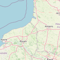
Use this park location map to pinpoint Réserve naturelle régionale de la côte de la Fontaine in France, understand its exact geographic position, and read its mapped placement within the surrounding landscape more clearly.

Pigeon | © OpenStreetMap contributors

Location context for Réserve naturelle régionale de la côte de la Fontaine

Normandie

Protected area views, calcareous slope habitats, and river valley scenery across Normandy

Visual Explorer and Landscape Photography of Réserve naturelle régionale de la côte de la Fontaine

Visual records capture the chalk coteau slopes, calcareous grasslands, and river panoramas defining Réserve naturelle régionale de la côte de la Fontaine. Detailed imagery reveals the protected terrain, distinct vegetation communities, and topographic transitions shaping this protected landscape.

A wide landscape view from a high vantage point overlooking the Seine River valley with green pastures, wooded areas, and a river bend.

Park atlas

Compare nearby calcareous slopes and protected river landscapes across the regional valley network.

Other Parks Near Réserve naturelle régionale de la côte de la Fontaine and Surrounding Protected Areas

Explore nearby protected areas and related valley reserves to compare regional chalk habitats and river ecosystems. Extending the geographic review helps place local limestone slope formations within the broader context of surrounding protected landscapes.
A watercolor painting showing a rolling rural landscape with green hills, scattered trees, and a light sky.
Nature reserveHauts-de-France
About 57 km away#1 closest

East

Réserve naturelle régionale des Larris et tourbières de Saint-Pierre-es-Champs Protected Area Geography

Regional nature reserve and limestone promontory in northern France

Understand the ecological and geological significance of the Réserve naturelle régionale des Larris et tourbières de Saint-Pierre-es-Champs. This site showcases a rare juxtaposition of dry chalk slopes and damp peatland habitats that characterize the local geography of the Pays de Bray, offering insight into the preservation of semi-natural landscapes through traditional conservation grazing practices.

Area
0.794 km²
Established
1992
IUCN
IV
Watercolor painting of a wide, soft green landscape featuring rolling hills, scattered trees, and meadows under a warm sky.
Nature reserveÎle-de-France
About 70 km away#2 closest

Southeast

Réserve naturelle régionale de la boucle de Moisson: Protected Seine Meander and Plain

Regional Nature Reserve in Île-de-France

Located in the Yvelines department, this protected area occupies a striking loop of the Seine river. The reserve preserves a blend of open meadow plains and birch-rich woodlands, offering insight into river valley geography and local landscape patterns within the Île-de-France basin.

Area
3.163 km²
Established
2009
IUCN
IV
Nature reserveÎle-de-France
About 80 km away#3 closest

Southeast

Réserve naturelle régionale du site géologique de Limay: Protected Landscapes and Geological Maps

A diverse nature reserve in the Yvelines department of Île-de-France.

Deeply rooted in the geological history of the Paris Basin, this former quarry site in Limay is now a thriving regional nature reserve. Its compact territory features a striking contrast between ancient limestone exposures and rich wetland pockets, providing a vital educational platform for studying biodiversity and land reclamation in north-central France.

Area
0.698 km²
Established
2009
IUCN
IV
Relief
Lowland
A watercolor illustration of a rural landscape with rolling green fields and distant trees, framed by delicate foliage in the foreground.
Nature reserveCentre-Val de Loire
About 81 km away#4 closest

Southeast

Réserve naturelle régionale de la Vallée des Cailles: Protected Area Map & Geography

Ecological landscape features in the Centre-Val de Loire

The Réserve naturelle régionale de la Vallée des Cailles encompasses forty-five hectares of calcareous chalk valley. This protected space preserves rare orchid species and diverse botanical communities shaped by a unique combination of flint geology, north-facing slopes, and long-running traditional land management practices.

Area
0.45 km²
Established
1999
IUCN
IV
Relief
Upland
Nature reserveÎle-de-France
About 85 km away#5 closest

Southeast

Réserve naturelle régionale du site géologique de Vigny-Longuesse: A Geological Reference Site

Protected limestone landscape in the Vexin region of Île-de-France

Protecting a critical paleontological and stratigraphic record, this reserve showcases a unique Tertiary reef complex. The site combines artificial quarry cliffs with natural geomorphological features, including paleolandslides and fossil-bearing limestone plates, providing a comprehensive outdoor archive of the Paris Basin.

Area
0.219 km²
Established
2009
IUCN
IV
Relief
Upland
Watercolor painting of a coastal salt marsh with winding tidal channels, grassy banks, and soft green and purple tones.
Nature reserveSomme
About 95 km away#6 closest

Northeast

Reserve naturelle nationale de la baie de Somme: Estuarine Geography and Protected Boundaries

Coastal mapping of the Somme estuary in northern France

Covering a wide range of tidal environments, the Reserve naturelle nationale de la baie de Somme represents one of France's most significant protected estuarine systems. This overview focuses on the interplay of river and tide, showcasing the expansive mudflats, salt marshes, and dune habitats that support immense bird populations and harbor seals along the Picardy shoreline.

Area
34.209 km²
Established
1994
IUCN
IV
Relief
Lowland
Nature reserveNormandie
About 97 km away#7 closest

South

Réserve naturelle régionale de la clairière forestière de Bresolettes: Normandy Protected Landscapes

Mapping forest ecosystems and historic industrial water features in the Perche region.

Spanning roughly 780 hectares, this regional nature reserve serves as a vital biodiversity refuge in northwestern France. The landscape integrates mature woodland, wet meadows, and mire ecosystems that support rare flora and specialized fauna, offering a clear view of the complex environmental history of the Perche forest.

Area
7.8 km²
Established
2010
IUCN
IV
A soft watercolor painting of a serene natural landscape featuring foreground grasses, a small body of water, a grassy shoreline, coniferous trees, and hazy hills in the background.
Nature reserveNormandie
About 98 km away#8 closest

West

Réserve naturelle nationale de la falaise du Cap-Romain: Coastal Nature Reserve Map

Explore protected maritime cliffs and Jurassic fossil sites in Calvados, France.

The Réserve naturelle nationale de la falaise du Cap-Romain stands as a compact but rich geological archive on the Côte de Nacre. It protects maritime cliffs, rocky tidal platforms, and significant Bathonian-age sponge fossil reefs. This site offers deep insights into the region's Quaternary history, encompassing glacial deposits, loess layers, and diverse marine fossil assemblages.

Area
0.24 km²
Established
1984
IUCN
III

Common questions about visiting, size, designation, and location context for Réserve naturelle régionale de la côte de la Fontaine

Réserve naturelle régionale de la côte de la Fontaine FAQs for park facts, access, geography, and protected area context

Find quick answers about Réserve naturelle régionale de la côte de la Fontaine, including protected-area facts, park geography, trail and visitor context, and how the park fits into its surrounding country and regional landscape.
MoriAtlas Explorer

Continue Your Protected Areas Search Across the Global Atlas

Deepen your exploration by continuing the structured search for national parks and protected areas worldwide. Utilize the comprehensive filtering capabilities to compare different conservation landscapes and refine your understanding of global park geography. Discover more about the distribution and characteristics of protected natural areas.

Global natural geography