Mori Atlas logo
Nature reserveRéserve naturelle régionale du site géologique de Vigny-Longuesse

A protected landscape featuring an international reference site for Tertiary reefs and complex stratigraphy

Réserve naturelle régionale du site géologique de Vigny-Longuesse: Geological Atlas of the Paris Basin

The Réserve naturelle régionale du site géologique de Vigny-Longuesse serves as a primary scientific archive within the Île-de-France region. This protected area preserves the only known Tertiary fossil reef complex in the Paris Basin, offering a rare window into ancient marine environments through its exposed limestone quarry walls and geomorphological structures. Visitors and researchers use the site to map paleoescarpments, study cryoturbated paleosols, and analyze the complex stratigraphic record of the Vexin plateau.

geological reservefossil reefpaleontological siteregional nature reservequarry sitecalcareous grassland

Réserve naturelle régionale du site géologique de Vigny-Longuesse

Nature reserve

Park overview

Structured park overview, official facts, and landscape profile for Vigny-Longuesse Regional Nature Reserve

Vigny-Longuesse Regional Nature Reserve park facts, protected area profile, and essential visitor context

Review the core facts for Vigny-Longuesse Regional Nature Reserve, including designation, size, terrain, visitor scale, habitats, and operating context in one park-focused overview.

About Vigny-Longuesse Regional Nature Reserve

The Vigny-Longuesse Regional Nature Reserve occupies a quiet corner of the Val-d'Oise, on the communes of Vigny and Longuesse, deep within the landscapes of the Vexin français. Its territory is small, only about 22 hectares, but its scientific significance far exceeds its size. The reserve protects the Carrière du Bois des Roches, an old limestone quarry whose cut walls expose a sequence of Cretaceous and Paleogene rocks that geologists across Europe have studied for decades.

Geologically, the quarry lies at the heart of the Vigny anticline, a fold structure locally punctured by a boutonnière that brings Campanian chalk and Danian limestone up to the surface. This particular window preserves something almost unique in northern France: a fossilized reef complex from the Tertiary, complete with structures that reveal how ancient marine organisms built and shaped a tropical carbonate platform. Because of this, the site functions both as a paleontological treasure trove, with more than 350 documented species, and as a historical co-stratotype for the Danian stage, giving it an importance that reaches well beyond regional borders.

The reserve sits inside the larger Parc naturel régional du Vexin français, where plateaus, dry valleys, and traditional building stone have long shaped local heritage. The quarry itself was worked from 1920 to produce the famed pierre de Vigny, a dense limestone prized for both construction and ornamentation in the châteaux and farmhouses of the Vexin. When extraction ended between 1999 and 2001, the site stood at a crossroads: a working industrial landscape on one hand, an irreplaceable geological archive on the other. The Val-d'Oise department acquired the land in 2003 under its Espaces Naturels Sensibles program, and in 2009 the site was formally classified as a regional nature reserve, locking in long-term protection.

Today Vigny-Longuesse is appreciated as a compact but layered place, simultaneously a reference geological site, a quiet pocket of calcareous habitat, and a teaching ground for school groups and researchers. Three belvederes with secure platforms, interpretive panels, and a sample box of local rocks allow visitors to engage directly with the stratigraphy exposed in the quarry faces. The result is a reserve that feels less like a sweeping wilderness and more like a focused, high-value outdoor classroom for the deep history of the Paris Basin.

Protection and recognition

Documented terrestrial protection scope, designation history, and official database records

Réserve naturelle régionale du site géologique de Vigny-Longuesse Protection Status

Terrestrial protection status for Réserve naturelle régionale du site géologique de Vigny-Longuesse establishes its official designation history starting in 2009. Official records outline the baseline conservation scope and administrative identifiers maintained within the global protected area registry.

Protection details

Protection scope
Terrestrial
Designated year
2009
Transboundary protection
No
WDPA ID
555514347
Park context

Deeper park guide and search-rich context for Vigny-Longuesse Regional Nature Reserve

Vigny-Longuesse Regional Nature Reserve history, landscape, wildlife, and travel context

Explore Vigny-Longuesse Regional Nature Reserve through its history, landscape character, ecosystems, wildlife, conservation priorities, cultural context, and seasonal travel timing in a structured park guide built for atlas discovery and search intent.

Why Vigny-Longuesse Regional Nature Reserve stands out

The reserve is best known for protecting the only known Tertiary fossil reef complex preserved in the Paris Basin. The Carrière du Bois des Roches exposes Danian limestone and Campanian chalk within an anticlinal structure breached by a geological window (boutonnière), creating a natural cross-section that is internationally recognized as a historical co-stratotype of the Danian stage. The site has yielded more than 350 identified fossil species, making it a major paleontological reference point as well as a stratigraphic one. The quarry faces also preserve rare geomorphological features including paleoescarpments, an in-place reef pavement partially collapsed into chaotic blocks, submarine paleolandslides, and paleosols bearing cryoturbation structures, all of which together qualify the site as a high-value inherited geomorphosite.
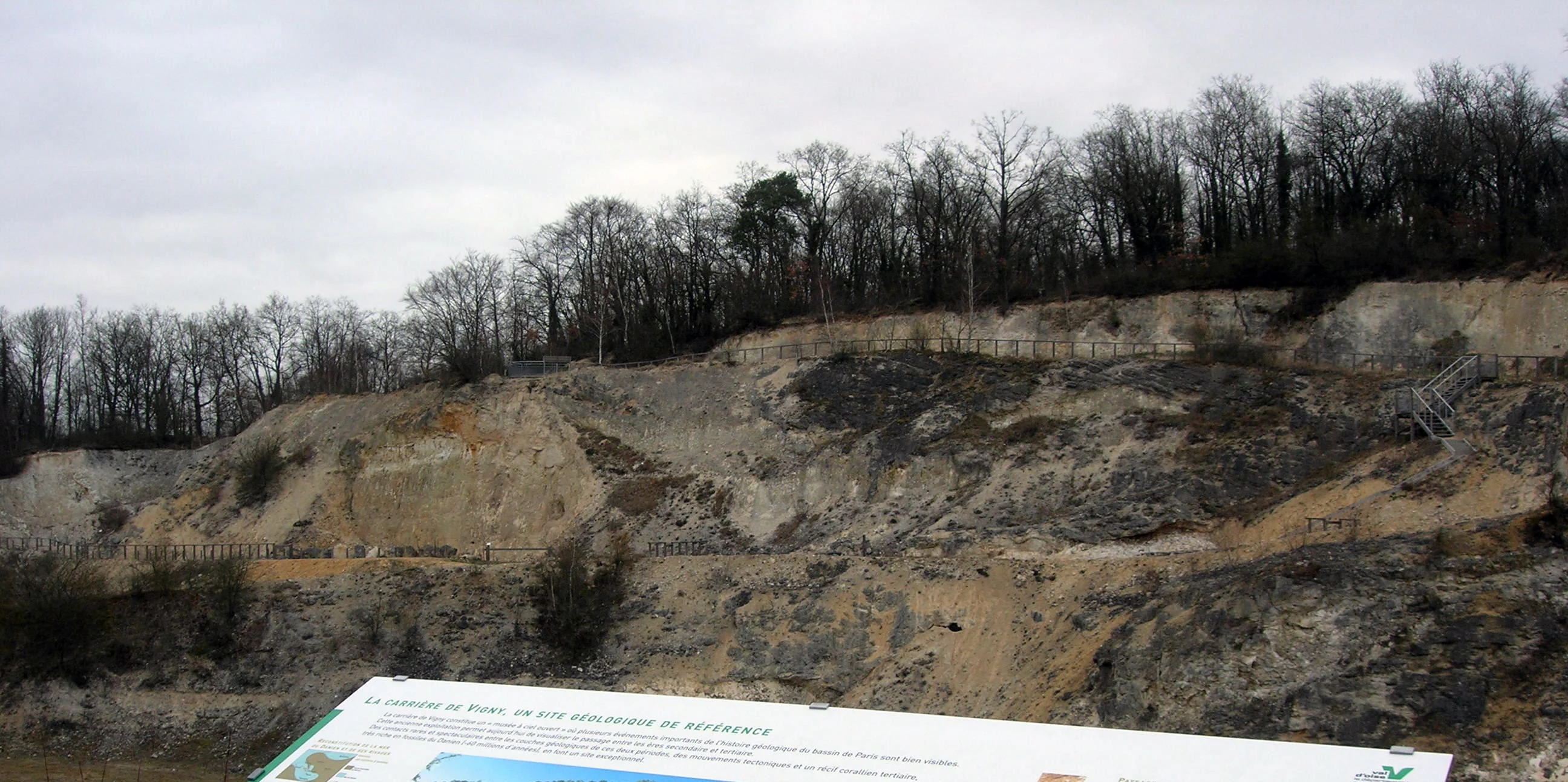
A wide view of a rocky, exposed quarry cliff face under a cloudy sky, with an educational sign in the foreground.
View of the Vigny geological quarry from the observation deck, featuring an informative sign in the foreground.

Vigny-Longuesse Regional Nature Reserve history and protected-area timeline

The story of Vigny-Longuesse begins not with conservation but with stone. The Carrière du Bois des Roches has been worked since 1920, supplying the pierre de Vigny, a dense, high-quality limestone used in the construction and restoration of traditional houses and châteaux across the Vexin. For most of the twentieth century the quarry was an active industrial site whose products shaped the regional built heritage.

Extraction continued into the late 1990s before finally winding down between 1999 and 2001. Once operations ceased, the exposed quarry faces, long appreciated by geologists for their fossil reefs and stratigraphic clarity, became both a vulnerability and an opportunity. With machinery gone, the site faced risks of degradation and uncontrolled access, yet it also stood revealed as a natural laboratory of international interest.

In 2003 the Conseil départemental du Val-d'Oise purchased the land through its Espaces Naturels Sensibles program, securing public ownership of this small but scientifically important site. Six years later, on 22 October 2009, the territory was formally classified as a regional nature reserve. The classification reflected a coalition of interests: the department, the local communes of Vigny and Longuesse, and scientific partners who had long championed the quarry's paleontological and stratigraphic value.

Since then, the reserve has become a focus for both protection and pedagogical use. The installation of belvederes, interpretive signage, and a geological sample station has translated the site's academic importance into a hands-on public experience, marking its transformation from a working quarry to a curated natural heritage site.

Vigny-Longuesse Regional Nature Reserve landscape and geographic character

The landscape of the reserve is shaped above all by the quarry itself. The Carrière du Bois des Roches bites into the plateau of the same name, its stepped faces and platforms forming a sequence of artificial cliffs that nonetheless read as a natural geological cross-section. Around the quarry margins the terrain rises gently toward the rim of the Bois des Roches plateau, while below, the floor of the workings collects a mix of fallen rock, grassy clearings, and shallow pools formed in the depressions of the quarry bottom.

At a broader scale, the reserve sits within the rolling plateau country of the Vexin français, a landscape of open fields, scattered woodlands, dry valleys, and small villages built from the same Vigny limestone that was once quarried here. The broader relief is subdued, marked by the long, gentle undulations typical of the western edge of the Île-de-France, but within the reserve itself the vertical relief is locally dramatic, with sheer quarry walls alongside flat working floors.

The most distinctive landscape features, however, are the geological structures themselves. Paleoescarpments along the quarry walls record ancient faulting, while a partially collapsed reef pavement forms a chaotic jumble of fallen blocks at the base of some faces. Submarine paleolandslides and paleosols marked by cryoturbation hint at dramatic events in the deeper past, freeze-thaw cycles, sediment slumping, and shifting sea levels, all frozen into the rock record. Together these features give the small reserve a landscape chronology that reads like a layered outdoor archive.

Vigny-Longuesse Regional Nature Reserve ecosystems, habitats, and plant life

Although small, the reserve supports a striking range of habitats. The bare rock of the quarry faces, the talus and rubble slopes below them, the grassy ledges and quarry floor, and the surrounding woodland and calcareous grassland of the Bois des Roches combine into a true habitat mosaic. This patchwork is the foundation of the site's biological diversity.

Calcareous grassland and rocky outcrops favor specialized plant communities adapted to thin, dry soils. Botanical surveys have recorded around 330 plant species across the reserve, roughly a quarter of the Île-de-France regional flora. Among these, three are particularly notable for their rarity in the area: the clustered bellflower (Campanule agglomérée), the dwarf restharrow (Bugrane naine), and Léman's fescue (Fétuque de Léman).

The mosaic also shapes animal communities. The mix of bare rock, scrub, and herbaceous vegetation creates favorable conditions for reptiles such as the wall lizard and slow worm, while sunny rocky areas host characteristic orthopterans like the blue-winged grasshopper (Œdipode bleue) and the Italian cricket. Damp microhabitats near the quarry floor and surrounding woodland support amphibians such as the midwife toad and the palmate newt. Insects overall are a major presence, and the diversity of microclimates within such a small footprint gives the reserve a disproportionately rich ecological profile for its size.

Vigny-Longuesse Regional Nature Reserve wildlife and species highlights

For a reserve defined primarily by geology, Vigny-Longuesse hosts a varied and ecologically meaningful fauna. Reptiles are a regular presence in the warm, sun-exposed rocky margins, where the wall lizard and the legless slow worm find both hunting grounds and shelter in the cracks and crevices of the limestone.

Amphibians make use of the moister retreats among the quarry floor and surrounding wooded edges, with species such as the midwife toad and the palmate newt recorded on site. Orthopterans, the grasshoppers and crickets, are particularly characteristic of the calcareous grassland and bare-rock habitats, with the blue-winged grasshopper and the Italian cricket among the species noted.

The mosaic of habitats, rock, rubble, grassland, scrub, woodland, also supports a broad insect fauna that underpins the food web for birds and other small predators. While the reserve is not primarily positioned as a birding site, its structural diversity gives it a consistent presence of common woodland, edge, and open-ground birdlife typical of the Vexin plateau landscape.

Vigny-Longuesse Regional Nature Reserve conservation status and protection priorities

The conservation significance of Vigny-Longuesse rests on its geological and paleontological rarity. Within the entire Paris Basin, it preserves the only known fossil reef complex of Tertiary age, a fact that gives it scientific importance well beyond its modest footprint of about 22 hectares. Its status as a historical co-stratotype for the Danian stage adds an internationally recognized stratigraphic dimension to that value.

The reserve also illustrates a model of post-industrial site conservation. Once extraction of the pierre de Vigny ended, the disused quarry would have faced gradual degradation without intervention. Public acquisition by the Val-d'Oise department in 2003, classification as a regional nature reserve in 2009, and ongoing management by the departmental council have together converted a vulnerable industrial scar into a protected natural heritage site.

Equally important is its role in preserving a high-value geomorphological inheritance. Paleoescarpments, collapsed reef blocks, submarine paleolandslides, and cryoturbated paleosols make the site a textbook example of an inherited geomorphosite. By safeguarding the visibility and accessibility of these features, the reserve protects not only fossils and rocks but a coherent landscape record of deep-time processes, an asset that, once lost through erosion, collapse, or redevelopment, could never be reconstructed.

Vigny-Longuesse Regional Nature Reserve cultural meaning and human context

The reserve is closely tied to the regional identity of the Vexin français, an area long characterized by its building stone, plateaus, and traditional rural architecture. The pierre de Vigny extracted from the very quarry now protected is the same limestone that gives shape to many of the Vexin's châteaux and farmhouses, embedding the site directly into the regional built heritage.

Local institutional involvement in the reserve's protection has been significant. The Conseil départemental du Val-d'Oise, the communes of Vigny and Longuesse, and scientific partners have together shaped both its management and its public image. Educational use of the site, through belvederes, panels, and a sample station, reflects a deliberate effort to share a piece of regional geological legacy with visitors, students, and researchers rather than to keep it as a hidden specialist site.

Top sights and standout views in Vigny-Longuesse Regional Nature Reserve

The reserve's defining highlight is the exposed reef complex of the Carrière du Bois des Roches, the only such Tertiary reef known in the Paris Basin, paired with the site's role as an international reference for the Danian stage.

Beyond that headline feature, the reserve stands out for the layered geomorphological story preserved in its quarry walls: paleoescarpments, collapsed reef pavement, submarine paleolandslides, and cryoturbated paleosols. Add to this a surprisingly rich flora of around 330 plant species in just 22 hectares, with three regionally rare species, and an accessible visitor setup of belvederes, panels, and a hands-on sample station, and the reserve becomes a compact, high-content destination for anyone interested in the deep geological history of northern France.
Monthly climate preview

Long-term representative monthly temperature and precipitation data measurements spanning 1991 through 2020

Climate Normals and Annual Temperature Rhythm for Réserve naturelle régionale du site géologique de Vigny-Longuesse

Historical climate records from a representative coordinate show steady thermal variation alongside consistent daily precipitation totals across the twelve-month cycle. Reviewing the complete monthly profile provides detailed context on long-term temperature ranges and precipitation patterns across the protected terrain.
Annual mean11 °C
3 °C19 °C
Jan
Feb
Mar
Apr10°
May13°
Jun17°
Jul19°
Aug19°
Sep15°
Oct11°
Nov
Dec
Warmest month
July

18.8 °C

Coolest month
January

3.1 °C

Wettest month
December

2.4 mm/day

Driest month
April

1.5 mm/day

Park location guide

Geography guide, regional context, and park location map for Vigny-Longuesse Regional Nature Reserve

Vigny-Longuesse Regional Nature Reserve park geography, regions, and map view in France

Understand where Vigny-Longuesse Regional Nature Reserve sits in France through a broader geographic reading of the surrounding landscape, nearby location context, and its mapped position within the national park landscape.

How Vigny-Longuesse Regional Nature Reserve fits into France

France is a unitary semi-presidential republic and one of the world's largest economies. It borders Belgium, Luxembourg, Germany, Switzerland, Italy, Monaco, Andorra, and Spain, with a maritime border to the United Kingdom. The country is known for its cultural influence, art, cuisine, and political history spanning centuries.

Wider geography shaping Vigny-Longuesse Regional Nature Reserve in France

France is located in Western Europe. Metropolitan France extends from the Rhine to the Atlantic Ocean and from the Mediterranean Sea to the English Channel and North Sea. The country borders Belgium, Luxembourg, Germany, Switzerland, Italy, Monaco, Andorra, Spain, and has a maritime border with the United Kingdom.

Map view of Vigny-Longuesse Regional Nature Reserve

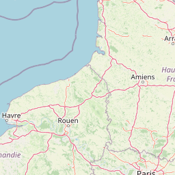
Use this park location map to pinpoint Vigny-Longuesse Regional Nature Reserve in France, understand its exact geographic position, and read its mapped placement within the surrounding landscape more clearly.

Pigeon | © OpenStreetMap contributors

Location context for Vigny-Longuesse Regional Nature Reserve

Île-de-France

Visualizing the ancient fossil reef complex, quarry faces, and limestone habitats

Réserve naturelle régionale du site géologique de Vigny-Longuesse Photos and Landscapes

Photographic collections reveal the steep limestone cliffs, exposed fossil strata, and quarry terrain that define Réserve naturelle régionale du site géologique de Vigny-Longuesse. Visual documentation provides essential context for interpreting the rare geological formations and protected natural habitats of the Paris Basin.

A wide view of a rocky, exposed quarry cliff face under a cloudy sky, with an educational sign in the foreground.

Park atlas

Compare surrounding regional nature reserves and protected landscapes across Île-de-France.

Parks Near Réserve Naturelle Régionale du Site Géologique de Vigny-Longuesse

Browse other protected areas and regional reserves situated throughout the surrounding limestone plateaus and river valleys. Comparing adjacent park geography reveals broader geological patterns and regional conservation contexts.
Nature reserveÎle-de-France
About 15 km away#1 closest

Southwest

Réserve naturelle régionale du site géologique de Limay: Protected Landscapes and Geological Maps

A diverse nature reserve in the Yvelines department of Île-de-France.

Deeply rooted in the geological history of the Paris Basin, this former quarry site in Limay is now a thriving regional nature reserve. Its compact territory features a striking contrast between ancient limestone exposures and rich wetland pockets, providing a vital educational platform for studying biodiversity and land reclamation in north-central France.

Area
0.698 km²
Established
2009
IUCN
IV
Relief
Lowland
Watercolor painting of a wide, soft green landscape featuring rolling hills, scattered trees, and meadows under a warm sky.
Nature reserveÎle-de-France
About 19 km away#2 closest

West

Réserve naturelle régionale de la boucle de Moisson: Protected Seine Meander and Plain

Regional Nature Reserve in Île-de-France

Located in the Yvelines department, this protected area occupies a striking loop of the Seine river. The reserve preserves a blend of open meadow plains and birch-rich woodlands, offering insight into river valley geography and local landscape patterns within the Île-de-France basin.

Area
3.163 km²
Established
2009
IUCN
IV
A pale, soft watercolor painting of a calm wetland or marsh, featuring muted green vegetation, light water reflection, and a gentle shoreline under a hazy sky.
Nature reserveÎle-de-France
About 22 km away#3 closest

East

Réserve naturelle régionale du marais de Stors: Atlas and Protected Landscape Overview

A rare wetland enclave in the Vallée de Chauvry

Focusing on the hydrological and ecological character of the Réserve naturelle régionale du marais de Stors, this overview examines its role as a protected nature reserve in the Paris region. Explore the marshland terrain and valley topography that define this unique pocket of conserved habitat in northern France.

Area
0.47 km²
Established
2009
IUCN
IV
A watercolor painting showing a rolling rural landscape with green hills, scattered trees, and a light sky.
Nature reserveHauts-de-France
About 41 km away#4 closest

North

Réserve naturelle régionale des Larris et tourbières de Saint-Pierre-es-Champs Protected Area Geography

Regional nature reserve and limestone promontory in northern France

Understand the ecological and geological significance of the Réserve naturelle régionale des Larris et tourbières de Saint-Pierre-es-Champs. This site showcases a rare juxtaposition of dry chalk slopes and damp peatland habitats that characterize the local geography of the Pays de Bray, offering insight into the preservation of semi-natural landscapes through traditional conservation grazing practices.

Area
0.794 km²
Established
1992
IUCN
IV
Nature reserveÎle-de-France
About 43 km away#5 closest

South

Réserve naturelle régionale du val et coteau de Saint-Rémy: Regional Nature Reserve Geography

A protected river valley and coteau habitat in Île-de-France

Spanning eighty-three hectares across five distinct parcels, this protected area serves as a vital ecological corridor along the Yvette river. Analyze the site's unique habitat distribution, ranging from moist bottomlands to dry, calcareous slopes, and trace its role in preserving regional biological diversity near Saint-Rémy-lès-Chevreuse.

Area
0.83 km²
Established
2008
IUCN
IV
A watercolor illustration of a rural landscape with rolling green fields and distant trees, framed by delicate foliage in the foreground.
Nature reserveCentre-Val de Loire
About 43 km away#6 closest

Southwest

Réserve naturelle régionale de la Vallée des Cailles: Protected Area Map & Geography

Ecological landscape features in the Centre-Val de Loire

The Réserve naturelle régionale de la Vallée des Cailles encompasses forty-five hectares of calcareous chalk valley. This protected space preserves rare orchid species and diverse botanical communities shaped by a unique combination of flint geology, north-facing slopes, and long-running traditional land management practices.

Area
0.45 km²
Established
1999
IUCN
IV
Relief
Upland
A soft, painterly watercolor illustration depicting a winding river flowing through a green basin with rolling hills, grasses, and scattered trees under a light sky.
Nature reserveÎle-de-France
About 45 km away#7 closest

Southeast

Réserve naturelle régionale du bassin de la Bièvre: Protected Wetland and Basin Geography

A vital urban nature reserve within the Île-de-France region

Located south of Paris, this six-hectare nature reserve demonstrates how an artificial stormwater basin can evolve into a functioning wetland. Its geography is defined by fluctuating water levels and reedbed habitats that provide sanctuary for migratory birds. Examine the protected boundaries and landscape terrain of this significant, compact ecological refuge in the Bièvre valley.

Area
0.06 km²
Established
2009
IUCN
IV
Relief
Lowland
Watercolor painting of a gentle, winding river or pond flowing through a green meadow with soft, rolling hills in the background under a pale sky.
Nature reserveÎle-de-France
About 51 km away#8 closest

South

Réserve naturelle régionale des étangs de Bonnelles: Regional Nature Reserve Geography

Wetland ecosystem analysis in the Yvelines department.

Defined by its two core ponds, this regional nature reserve creates a critical mosaic of wetland, marsh, and woodland habitats. It stands out in the Île-de-France area as a concentrated zone of freshwater biodiversity, supporting a variety of avian and invertebrate life in a region where such undisturbed watery terrain is limited.

Area
0.221 km²
Established
1990
IUCN
IV
Relief
Lowland

Common questions about visiting, size, designation, and location context for Vigny-Longuesse Regional Nature Reserve

Vigny-Longuesse Regional Nature Reserve FAQs for park facts, access, geography, and protected area context

Find quick answers about Vigny-Longuesse Regional Nature Reserve, including protected-area facts, park geography, trail and visitor context, and how the park fits into its surrounding country and regional landscape.
MoriAtlas Explorer

Continue Your Protected Areas Search Across the Global Atlas

Deepen your exploration by continuing the structured search for national parks and protected areas worldwide. Utilize the comprehensive filtering capabilities to compare different conservation landscapes and refine your understanding of global park geography. Discover more about the distribution and characteristics of protected natural areas.

Global natural geography