Mori Atlas logo
Nature reserveRéserve naturelle régionale du site géologique de Limay

Discover the unique mosaic of habitats and ancient rock strata within this Île-de-France nature reserve.

Réserve naturelle régionale du site géologique de Limay: A Geological and Ecological Heritage Site

(Réserve naturelle régionale du site géologique de Limay (RNR208))

Located on the right bank of the Seine in the Yvelines department, this nature reserve serves as an accessible window into the deep geological timeline of the Paris Basin. Spanning 35 million years of rock layers, the site functions as an outdoor classroom where limestone and clay outcrops meet a reclaimed mosaic of dry and wet habitats. This protected landscape offers a distinctive look at how industrial quarry sites transition into high-biodiversity refuges within the densly populated Île-de-France region.

geological reserveformer quarryregional nature reserveIle-de-FranceYvelinesParis Basin geology

Réserve naturelle régionale du site géologique de Limay

Nature reserve

Park overview

Structured park overview, official facts, and landscape profile for Réserve naturelle régionale du site géologique de Limay

Réserve naturelle régionale du site géologique de Limay park facts, protected area profile, and essential visitor context

Review the core facts for Réserve naturelle régionale du site géologique de Limay, including designation, size, terrain, visitor scale, habitats, and operating context in one park-focused overview.

About Réserve naturelle régionale du site géologique de Limay

The Réserve naturelle régionale du site géologique de Limay is a regional nature reserve located in the commune of Limay, on the right bank of the Seine in the Yvelines department of the Île-de-France region. Marked as RNR208 in the French regional nature reserve system, the reserve covers a little over 70 hectares on the edge of the Parc naturel régional du Vexin français, within easy reach of the western suburbs of the Paris metropolitan area.

The reserve occupies a former quarry worked for half a century by the Lafarge company for limestone and clay used in cement production. After extraction ceased in the late twentieth century, the site was progressively reclaimed by nature, and its industrial scars were transformed into a refuge for a striking variety of habitats. The geological faces, plateaus, slopes, and depressions of the old workings now expose rock layers from the Late Cretaceous through the Lutetian stage of the Eocene, giving visitors and researchers a continuous record of approximately 35 million years of sedimentation in the Paris Basin.

Ecologically, the reserve is defined by contrast. Dry habitats such as xeric grasslands, orchid-rich meadows, shrub thickets, and open woodlands cover the higher slopes, while wetlands, ponds, and damp hollows occupy the lower ground. The result is a dense mosaic of micro-habitats for a relatively small area, supporting more than 400 plant species and an estimated total of over a thousand species of fauna.

Because of its peri-urban location, its compact footprint, and the visibility of its features, the reserve has become an important site for environmental education. The co-managing bodies, the commune of Limay and the Parc naturel régional du Vexin français, run year-round guided walks and structured programs for schoolchildren, college students, and the general public. Access to the reserve is regulated at all times in order to protect both the geological outcrops and the sensitive habitats that have developed since quarrying ended.

Quick facts and research context for Réserve naturelle régionale du site géologique de Limay

The reserve covers slightly more than 70 hectares of an old quarry on the right bank of the Seine in the commune of Limay, Yvelines, in the Île-de-France region. Geologically, it preserves the Late Cretaceous and Eocene stages of the Paris Basin, including the Campanian, Ypresian, and Lutetian levels, an interval spanning on the order of 35 million years.

The area is classified as an IUCN Category IV protected area and is included in the French ZNIEFF type I inventory as the Carrière de Limay. Botanical surveys have documented more than 400 plant species, of which 83 are considered remarkable, including 16 orchid species. The fauna is estimated at over a thousand species overall, including more than 100 bird species, of which roughly 60 nest on the site.

Protection and recognition

Review documented terrestrial protection scope and official conservation designations

Protection Status and International Recognition for Réserve Naturelle Régionale du Site Géologique de Limay

Terrestrial protection records and baseline management criteria outline the conservation framework established for Réserve naturelle régionale du site géologique de Limay. Official database identifiers track the registered protected area boundaries without attributing unverified international recognition statuses.

Protection details

Protection scope
Terrestrial
Transboundary protection
No
WDPA ID
555514339
Park context

Deeper park guide and search-rich context for Réserve naturelle régionale du site géologique de Limay

Réserve naturelle régionale du site géologique de Limay history, landscape, wildlife, and travel context

Explore Réserve naturelle régionale du site géologique de Limay through its history, landscape character, ecosystems, wildlife, conservation priorities, cultural context, and seasonal travel timing in a structured park guide built for atlas discovery and search intent.

Why Réserve naturelle régionale du site géologique de Limay stands out

The reserve is best known for its geological exposures, an unusually accessible window into the history of the Paris Basin across the Cretaceous-Eocene transition, and for the ecological richness that has developed on a former industrial site. Its combination of dry and wet habitats within a single compact territory gives it a habitat density uncommon for the Île-de-France region. It also stands out as a regional reference for orchid-rich grasslands and for the presence of protected plant species such as Orobanche purpurea and Zannichellia palustris, as well as for a notable population of marsh helleborine orchids. The site is widely used as a teaching and awareness platform for geology, biodiversity, and the reconversion of industrial land.

Réserve naturelle régionale du site géologique de Limay history and protected-area timeline

The site that is now the Réserve naturelle régionale du site géologique de Limay was an active industrial quarry for fifty years. From 1928 to 1978, the Lafarge company extracted limestone and clay at Limay, supplying a local cement works and later shipping the clay alone to a cement plant at Cormeilles-en-Parisis. Extraction ceased at the end of the 1970s activity window, and the quarry was abandoned for more than a decade.

In 1992, with extraction definitively over, the former operator began safety works and ecological rehabilitation of the site. By 2003, a proposal had been put forward to register the area as a ZNIEFF (Zone naturelle d'intérêt écologique, faunistique et floristique), which in turn led, from 2005 onward, to a formal ecological diagnosis of the site.

In 2006, the commune of Limay acquired the site, supported by the Île-de-France region, with the express goal of securing its protection. The project culminated in 2009 with a deliberation by the regional council creating the regional nature reserve on 22 October 2009, for an initial term of twelve years, renewable. Since then the reserve has been jointly managed by the commune of Limay and the Parc naturel régional du Vexin français, and it is also identified within the national ZNIEFF type I inventory as the Carrière de Limay (reference 110020410).

Réserve naturelle régionale du site géologique de Limay landscape and geographic character

The reserve sits within the meandering landscape of the Seine valley in the Vexin area, on the right bank of the river just upstream of Limay. The terrain is shaped by the abandoned quarry, whose workings have left a varied topography of exposed faces, fragmented slopes, intermediate ledges, plateau surfaces, and lower depressions that have filled with water.

The surrounding regional landscape reflects the characteristic geology of the Paris Basin margins, where the river's loops have cut into Cretaceous chalk, clays, and loams, repeatedly exposing multilayered outcrops. Within the reserve itself this larger pattern is concentrated and amplified: visitors can see the contacts between three distinct geological stages, the Campanian, the Ypresian, and the Lutetian, in close succession.

The result is a visually unusual patchwork for the Île-de-France region: pale limestone faces and clay cuttings set against scrubby slopes, dense thickets, open plateaus, and intimate wetland hollows. The reserve's compact size and the abrupt transitions between dry and damp ground give the site a sense of varied geography compressed into a small footprint, especially visible on the seasonal imagery of the plateau under snow, autumn color, and winter fog.

Réserve naturelle régionale du site géologique de Limay ecosystems, habitats, and plant life

The reserve's ecological value rests on the close coexistence of dry and wet habitats within a few dozen hectares. From the dry, well-drained slopes the reserve inherits xeric grasslands, friche vegetation, open shrub thickets, and light woodlands. Lower ground collects moisture, producing ponds and marshy areas that contrast strongly with the dry upper surfaces.

Among these habitats, the orchid-rich meadows are particularly notable. Surveys have catalogued 16 orchid species, including what is considered one of the most regionally significant populations of marsh helleborine. Other grassland species contribute to a flora of more than 400 plant taxa, of which 83 are considered remarkable at regional level.

Protected or notable plant species confirmed in the reserve include Orobanche purpurea and Zannichellia palustris, both protected at the regional level in Île-de-France. The mosaic of habitats supports a wide range of invertebrates and pollinator groups, while the contrast between dry and wet environments allows species with very different ecological requirements to coexist within the same small site.

Réserve naturelle régionale du site géologique de Limay wildlife and species highlights

Despite its small size, the reserve hosts a remarkably rich fauna, estimated at more than a thousand species across all groups. Birds are particularly prominent: around 105 species have been recorded, of which approximately 62 breed on the site. Among them, characteristic species include the Eurasian stone-curlew, the cirl bunting, the little owl, the northern lapwing, and the little grebe.

The reserve is also significant for amphibians and odonates. Nine amphibian species are present, including the natterjack toad in its more typical French peri-urban habitat, and 34 dragonfly and damselfly species have been recorded. This high odonate count reflects the quality of the wetland habitats that have developed in the lower parts of the former quarry.

The varied plant communities and structural complexity of scrubland and grassland also support a large entomofauna, with flowering thistles in particular providing both nectar and seed resources, sometimes described informally as a winter 'birds' café'. The combination of breeding habitat, foraging habitat, and seasonal refuges makes the reserve disproportionately valuable for wildlife relative to its surface area.

Réserve naturelle régionale du site géologique de Limay conservation status and protection priorities

The reserve carries IUCN Category IV status and is the principal conservation designation for the site, complemented by its recognition as a ZNIEFF type I area. Its creation in 2009 reflects a deliberate effort to lock in the long-term protection of both geological exposures and ecological habitats on a former industrial site of clear regional interest.

From a conservation perspective, the reserve's importance lies less in rare individual species and more in the maintenance of a habitat mosaic that would be hard to recreate elsewhere in the densely populated Île-de-France region. The juxtaposition of xeric and wetland habitats on a single site, combined with a geology that reveals several stages of the Paris Basin at outcrop, gives the reserve both biodiversity and geoheritage value.

The current management framework, with the commune of Limay and the Parc naturel régional du Vexin français as joint managers, emphasizes regulated access, ongoing ecological monitoring, and active public engagement. Continuing challenges include balancing increasing public interest in the site with the protection of both fragile geological features and sensitive habitats, but the reserve has the legal and institutional backing to manage these tensions over twelve-year renewable cycles.

Réserve naturelle régionale du site géologique de Limay cultural meaning and human context

The reserve's human story is part of its identity. For half a century, from 1928 to 1978, the site was an industrial quarry feeding cement production, first to a local plant and later to the cement works at Cormeilles-en-Parisis. The transformation of that land from working quarry to protected natural area is itself a notable chapter of recent local history in the Yvelines and reflects a broader French pattern of converting post-industrial land into reserves.

Limay itself, near Mantes-la-Jolie, lies within a long-settled stretch of the Seine valley, and the reserve now sits at the meeting point of that older rural and river-valley identity with the peri-urban expansion of western Paris. Co-management by the commune together with the Parc naturel régional du Vexin français ties the site to the wider cultural and landscape project of the Vexin français, a regional natural park that emphasizes the rural and historical character of the area north-west of the capital.

Top sights and standout views in Réserve naturelle régionale du site géologique de Limay

Three features together define the reserve's identity for visitors and researchers: a 35-million-year geological sequence readable in a few hundred meters of outcrop, a compact mosaic of dry and wet habitats built from a former quarry, and an unusually high biodiversity count for such a small, accessible site in the Île-de-France.

On top of this, the reserve plays a strong role as an outdoor classroom for geology, botany, and biodiversity, with active programs for school groups from primary school through to master's level. Its character changes strongly with the seasons, from snow-covered plateaus and misty winter mornings to colorful autumns and rich spring flora, reinforcing its role as a place where geology, ecology, and education meet on a site whose history is itself part of the message.

Best time to visit Réserve naturelle régionale du site géologique de Limay

The reserve is open year-round, but the experience varies strongly with season. Spring is the most rewarding period for botany and orchid enthusiasts, when most of the site's 16 orchid species flower and the grasslands come into full color. Early summer adds active breeding bird and insect life, with butterflies, dragonflies, and the reserve's amphibian populations at their most visible around the wetlands.

Autumn brings strong color to the woodlands and thickets and a more contemplative atmosphere, while winter reveals the site's bare geological faces and broad plateau surfaces most clearly, especially under snow or in low morning mist. Because access is regulated and most visits happen as part of guided walks and educational programs, prospective visitors typically engage with the schedule of the co-managing bodies rather than visiting independently at any chosen moment.
Monthly climate preview

Long-term representative climate patterns and monthly averages across the protected terrain

Annual Temperature And Precipitation Normals For Réserve Naturelle Régionale Du Site Géologique De Limay

Representative coordinates record measured monthly temperature swings from winter minimums to summer maximums alongside consistent daily precipitation amounts. Detailed twelve-month climate tables provide a complete statistical profile for the protected area.
Annual mean11 °C
3 °C19 °C
Jan
Feb
Mar
Apr10°
May13°
Jun17°
Jul19°
Aug19°
Sep15°
Oct11°
Nov
Dec
Warmest month
July

18.8 °C

Coolest month
January

3.1 °C

Wettest month
December

2.4 mm/day

Driest month
April

1.5 mm/day

Park location guide

Geography guide, regional context, and park location map for Réserve naturelle régionale du site géologique de Limay

Réserve naturelle régionale du site géologique de Limay park geography, regions, and map view in France

Understand where Réserve naturelle régionale du site géologique de Limay sits in France through a broader geographic reading of the surrounding landscape, nearby location context, and its mapped position within the national park landscape.

How Réserve naturelle régionale du site géologique de Limay fits into France

France is a unitary semi-presidential republic and one of the world's largest economies. It borders Belgium, Luxembourg, Germany, Switzerland, Italy, Monaco, Andorra, and Spain, with a maritime border to the United Kingdom. The country is known for its cultural influence, art, cuisine, and political history spanning centuries.

Wider geography shaping Réserve naturelle régionale du site géologique de Limay in France

France is located in Western Europe. Metropolitan France extends from the Rhine to the Atlantic Ocean and from the Mediterranean Sea to the English Channel and North Sea. The country borders Belgium, Luxembourg, Germany, Switzerland, Italy, Monaco, Andorra, Spain, and has a maritime border with the United Kingdom.

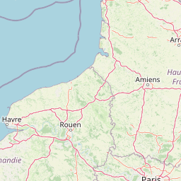
Map view of Réserve naturelle régionale du site géologique de Limay

Use this park location map to pinpoint Réserve naturelle régionale du site géologique de Limay in France, understand its exact geographic position, and read its mapped placement within the surrounding landscape more clearly.

Pigeon | © OpenStreetMap contributors

Location context for Réserve naturelle régionale du site géologique de Limay

Île-de-France
Park atlas

Compare surrounding regional landscapes and connected protected terrain across the Paris Basin

Other Protected Areas and Parks Near Réserve naturelle régionale du site géologique de Limay

Browsing other protected areas near Réserve naturelle régionale du site géologique de Limay allows users to evaluate neighboring geological sites and river valley habitats in the Île-de-France region. Expanding the park comparison reveals broader regional conservation patterns and related protected landscapes throughout the surrounding Yvelines department.
Watercolor painting of a wide, soft green landscape featuring rolling hills, scattered trees, and meadows under a warm sky.
Nature reserveÎle-de-France
About 9.6 km away#1 closest

Northwest

Réserve naturelle régionale de la boucle de Moisson: Protected Seine Meander and Plain

Regional Nature Reserve in Île-de-France

Located in the Yvelines department, this protected area occupies a striking loop of the Seine river. The reserve preserves a blend of open meadow plains and birch-rich woodlands, offering insight into river valley geography and local landscape patterns within the Île-de-France basin.

Area
3.163 km²
Established
2009
IUCN
IV
Nature reserveÎle-de-France
About 15 km away#2 closest

Northeast

Réserve naturelle régionale du site géologique de Vigny-Longuesse: A Geological Reference Site

Protected limestone landscape in the Vexin region of Île-de-France

Protecting a critical paleontological and stratigraphic record, this reserve showcases a unique Tertiary reef complex. The site combines artificial quarry cliffs with natural geomorphological features, including paleolandslides and fossil-bearing limestone plates, providing a comprehensive outdoor archive of the Paris Basin.

Area
0.219 km²
Established
2009
IUCN
IV
Relief
Upland
A watercolor illustration of a rural landscape with rolling green fields and distant trees, framed by delicate foliage in the foreground.
Nature reserveCentre-Val de Loire
About 28 km away#3 closest

Southwest

Réserve naturelle régionale de la Vallée des Cailles: Protected Area Map & Geography

Ecological landscape features in the Centre-Val de Loire

The Réserve naturelle régionale de la Vallée des Cailles encompasses forty-five hectares of calcareous chalk valley. This protected space preserves rare orchid species and diverse botanical communities shaped by a unique combination of flint geology, north-facing slopes, and long-running traditional land management practices.

Area
0.45 km²
Established
1999
IUCN
IV
Relief
Upland
A pale, soft watercolor painting of a calm wetland or marsh, featuring muted green vegetation, light water reflection, and a gentle shoreline under a hazy sky.
Nature reserveÎle-de-France
About 36 km away#4 closest

East

Réserve naturelle régionale du marais de Stors: Atlas and Protected Landscape Overview

A rare wetland enclave in the Vallée de Chauvry

Focusing on the hydrological and ecological character of the Réserve naturelle régionale du marais de Stors, this overview examines its role as a protected nature reserve in the Paris region. Explore the marshland terrain and valley topography that define this unique pocket of conserved habitat in northern France.

Area
0.47 km²
Established
2009
IUCN
IV
Nature reserveÎle-de-France
About 42 km away#5 closest

Southeast

Réserve naturelle régionale du val et coteau de Saint-Rémy: Regional Nature Reserve Geography

A protected river valley and coteau habitat in Île-de-France

Spanning eighty-three hectares across five distinct parcels, this protected area serves as a vital ecological corridor along the Yvette river. Analyze the site's unique habitat distribution, ranging from moist bottomlands to dry, calcareous slopes, and trace its role in preserving regional biological diversity near Saint-Rémy-lès-Chevreuse.

Area
0.83 km²
Established
2008
IUCN
IV
A watercolor painting showing a rolling rural landscape with green hills, scattered trees, and a light sky.
Nature reserveHauts-de-France
About 45 km away#6 closest

North

Réserve naturelle régionale des Larris et tourbières de Saint-Pierre-es-Champs Protected Area Geography

Regional nature reserve and limestone promontory in northern France

Understand the ecological and geological significance of the Réserve naturelle régionale des Larris et tourbières de Saint-Pierre-es-Champs. This site showcases a rare juxtaposition of dry chalk slopes and damp peatland habitats that characterize the local geography of the Pays de Bray, offering insight into the preservation of semi-natural landscapes through traditional conservation grazing practices.

Area
0.794 km²
Established
1992
IUCN
IV
Watercolor painting of a gentle, winding river or pond flowing through a green meadow with soft, rolling hills in the background under a pale sky.
Nature reserveÎle-de-France
About 48 km away#7 closest

Southeast

Réserve naturelle régionale des étangs de Bonnelles: Regional Nature Reserve Geography

Wetland ecosystem analysis in the Yvelines department.

Defined by its two core ponds, this regional nature reserve creates a critical mosaic of wetland, marsh, and woodland habitats. It stands out in the Île-de-France area as a concentrated zone of freshwater biodiversity, supporting a variety of avian and invertebrate life in a region where such undisturbed watery terrain is limited.

Area
0.221 km²
Established
1990
IUCN
IV
Relief
Lowland
A soft, painterly watercolor illustration depicting a winding river flowing through a green basin with rolling hills, grasses, and scattered trees under a light sky.
Nature reserveÎle-de-France
About 48 km away#8 closest

Southeast

Réserve naturelle régionale du bassin de la Bièvre: Protected Wetland and Basin Geography

A vital urban nature reserve within the Île-de-France region

Located south of Paris, this six-hectare nature reserve demonstrates how an artificial stormwater basin can evolve into a functioning wetland. Its geography is defined by fluctuating water levels and reedbed habitats that provide sanctuary for migratory birds. Examine the protected boundaries and landscape terrain of this significant, compact ecological refuge in the Bièvre valley.

Area
0.06 km²
Established
2009
IUCN
IV
Relief
Lowland

Common questions about visiting, size, designation, and location context for Réserve naturelle régionale du site géologique de Limay

Réserve naturelle régionale du site géologique de Limay FAQs for park facts, access, geography, and protected area context

Find quick answers about Réserve naturelle régionale du site géologique de Limay, including protected-area facts, park geography, trail and visitor context, and how the park fits into its surrounding country and regional landscape.
MoriAtlas Explorer

Continue Your Protected Areas Search Across the Global Atlas

Deepen your exploration by continuing the structured search for national parks and protected areas worldwide. Utilize the comprehensive filtering capabilities to compare different conservation landscapes and refine your understanding of global park geography. Discover more about the distribution and characteristics of protected natural areas.

Global natural geography