
Mori Atlas logo
Nature reserveRéserve naturelle régionale du bassin de la Bièvre

A rare urban wetland ecosystem preserving vital riverine habitats in the heart of Île-de-France.

Réserve naturelle régionale du bassin de la Bièvre: Protected Wetland Geography and Map

The Réserve naturelle régionale du bassin de la Bièvre stands as an essential protected area within the highly urbanized landscape of Île-de-France. This former stormwater retention basin now functions as a dynamic wetland, featuring a complex mosaic of reedbeds, willow thickets, and fluctuating muddy banks. Through structured geographic mapping, this site reveals the ecological potential of engineered flood-control infrastructure to serve as a vital refuge for avian species.

wetland reserveurban wetlandstormwater basinreedbedbirdwatchingregional nature reserve
A stylized vector illustration of a deep canyon with a tall waterfall, surrounded by evergreen trees and rocky cliffs under a light sun.

Réserve naturelle régionale du bassin de la Bièvre

Nature reserve

Park overview

Structured park overview, official facts, and landscape profile for Réserve naturelle régionale du bassin de la Bièvre

Réserve naturelle régionale du bassin de la Bièvre park facts, protected area profile, and essential visitor context

Review the core facts for Réserve naturelle régionale du bassin de la Bièvre, including designation, size, terrain, visitor scale, habitats, and operating context in one park-focused overview.

About Réserve naturelle régionale du bassin de la Bièvre

The Réserve naturelle régionale du bassin de la Bièvre is a compact regional nature reserve classified in 2009 and located in the Île-de-France region, in the densely built southern suburbs of Paris. Despite covering only about six hectares across the communes of Antony and Verrières-le-Buisson, it holds an ecological significance that is disproportionate to its size, because it preserves a fragment of wetland habitat that has almost entirely disappeared from the Paris metropolitan region.

At the heart of the reserve is a former storm-water retention basin originally excavated in the 1970s as part of urban flood management. Once the engineering works were complete and the immediate surroundings stabilized, the basin was colonized naturally by wetland vegetation. Over the following decades, the basin matured into a mosaic of reedbeds, willow stands, wet woodlands, open water, and seasonally exposed banks, a combination of small habitats that supports a dense and varied biological community.

The reserve's biodiversity record includes 198 plant species, 8 mammal species, 3 amphibians, 2 reptiles, 12 fish species, and 151 bird species, for a total inventory of around 374 species. Its bird community is especially significant, with rare winter visitors, rare passage migrants, and breeding species that find the wetland conditions they need within an otherwise dry and sealed urban landscape. The reserve's formal designation followed a long recognition process: ZNIEFF status in 1984, departmental Espace Naturel Sensible status in 2001, and finally regional nature reserve status on 9 July 2009.

Governance is shared between two organizations with very different missions. The SIAAP (Syndicat interdépartemental pour l'assainissement de l'agglomération parisienne), the public sanitation authority that manages the hydrological infrastructure, is one co-manager; the Centre Ornithologique Île-de-France (CORIF), a regional ornithological association, is the other. This unusual partnership has shaped the reserve as both a working piece of urban water infrastructure and a carefully monitored wildlife site, and it offers a model for the way engineered environments can be reconsidered as ecological assets within metropolitan regions.

Quick facts and research context for Réserve naturelle régionale du bassin de la Bièvre

The Réserve naturelle régionale du bassin de la Bièvre is a French regional nature reserve (réserve naturelle régionale), classified under the regional authority of Île-de-France and referenced as RNR206. It sits in the southern inner suburbs of the Paris metropolitan area, spanning the communes of Antony in Hauts-de-Seine and Verrières-le-Buisson in Essonne. The protected area covers approximately 5.96 hectares, an unusually small footprint for a formally designated nature reserve.

Ecologically, it centers on a former storm-water retention basin originally dug in the 1970s to protect surrounding neighborhoods from flooding. Over time, wetland habitats including reedbeds, willow thickets, wet woodland, open water, and exposed mudflats developed naturally. The site was recognized as a ZNIEFF in 1984, designated an Espace Naturel Sensible in 2001, and formally classed as a regional nature reserve on 9 July 2009.

It is co-managed by the Syndicat interdépartemental pour l'assainissement de l'agglomération parisienne (SIAAP) and the Centre Ornithologique Île-de-France (CORIF), reflecting its dual identity as both a piece of urban water infrastructure and a bird-focused natural area. The reserve supports a recorded total of around 374 species, of which 151 are bird species, including several rare wintering and migratory wetland birds.

Protection and recognition

Review documented terrestrial protection scope and baseline designation facts for the reserve

Protection Status and International Recognition for Réserve naturelle régionale du bassin de la Bièvre

Terrestrial protection status records for Réserve naturelle régionale du bassin de la Bièvre outline baseline conservation parameters and official data registries. Documented management scope details provide structured reference data for conservation research and protected area analysis.

Protection details

Protection scope
Terrestrial
Transboundary protection
No
WDPA ID
555514371
Park context

Deeper park guide and search-rich context for Réserve naturelle régionale du bassin de la Bièvre

Réserve naturelle régionale du bassin de la Bièvre history, landscape, wildlife, and travel context

Explore Réserve naturelle régionale du bassin de la Bièvre through its history, landscape character, ecosystems, wildlife, conservation priorities, cultural context, and seasonal travel timing in a structured park guide built for atlas discovery and search intent.

Why Réserve naturelle régionale du bassin de la Bièvre stands out

The reserve is best known for being one of the few remaining functional wetlands in the dense inner suburbs south of Paris, and for the way it transformed an artificial flood-control basin into a refuge for wetland birds. Its bird list includes rare wintering species such as the common snipe, water rail, jack snipe, and Eurasian bittern, and rare passage migrants like the spotted crake, little bittern, and great reed warbler, giving it an ornithological importance far out of proportion to its very small size. It is also recognized as a rare survival of Bièvre riverine habitat. The Bièvre, a historic Seine tributary, was progressively covered over, diverted, and lost to the expansion of Paris, and this small basin preserves a fragment of the wetland character that once defined the valley. Finally, the reserve is a notable example of cooperation between a public sanitation utility and a regional naturalist association, a governance model that has become a reference for small urban-adjacent nature reserves in France.
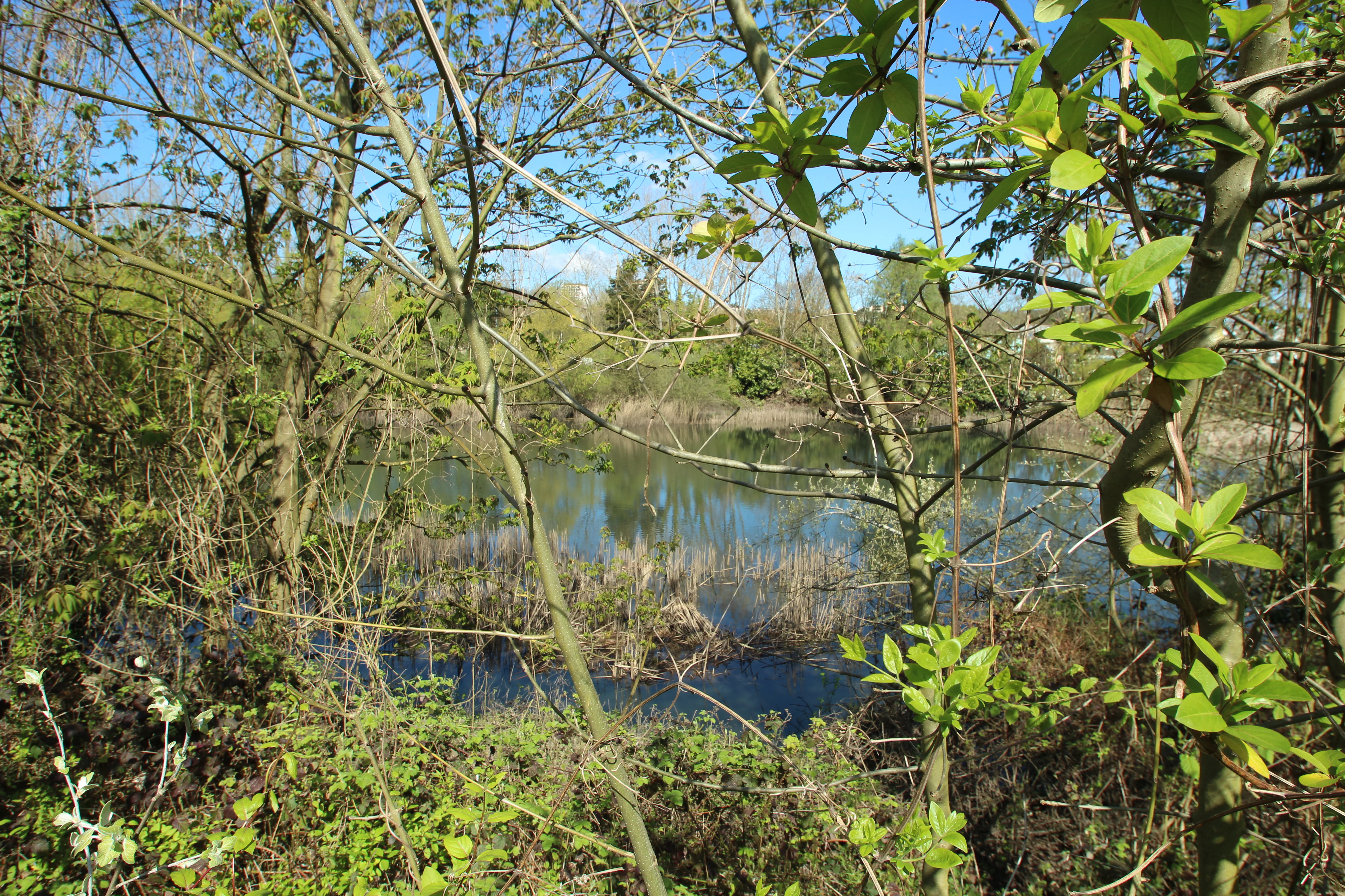
A view through dense spring foliage of a calm wetland pond surrounded by trees and shrubs in the Bièvre Basin Nature Reserve.
A view of the wetland basin within the Réserve naturelle régionale du bassin de la Bièvre, captured in April.

Réserve naturelle régionale du bassin de la Bièvre history and protected-area timeline

The basin that would become the nature reserve was excavated in the 1970s as a storm-water retention facility, designed to capture rainfall runoff and reduce flood risk in surrounding neighborhoods. Its construction reflected the broader mid-twentieth-century effort to manage surface water in the rapidly urbanizing southern outskirts of Paris, where former riverine landscapes such as the Bièvre valley were being sealed under new development.

Once the basin was operational and regular maintenance ensured its stability, wetland vegetation began to establish spontaneously. Over the following years, reedbeds, willow thickets, and wet woodland developed along the margins of the retained water, while invertebrate and vertebrate communities colonized in turn. This biological maturation led, in 1984, to the classification of the site as a ZNIEFF (Zone naturelle d'intérêt écologique, faunistique et floristique), giving it formal recognition as an ecologically valuable area within the French biodiversity inventory framework.

The drive toward stronger protection gained momentum in the 1990s. From 1995 onward, partners began exploring the possibility of classifying the site as a fully fledged nature reserve. In 2001, the basin was designated an Espace Naturel Sensible by the Hauts-de-Seine department, bringing additional recognition and funding support. The process culminated on 9 July 2009, when the regional council of Île-de-France formally classed the basin as a Réserve naturelle régionale. Co-management responsibility was assigned jointly to the SIAAP and the Centre Ornithologique Île-de-France, formalizing the partnership between public infrastructure management and specialized ornithological expertise that has shaped the reserve ever since.

Réserve naturelle régionale du bassin de la Bièvre landscape and geographic character

The reserve sits in a transitional zone at the edge of the built-up Parisian suburbs, where residential development, business parks, and transport infrastructure dominate the surroundings. Within this context, the protected area is essentially a bowl shaped landscape feature, a sunken basin whose lowest points hold open water and whose margins rise gently into vegetated banks and woodland edges.

Topographically, the site is modest: there are no cliffs, mountains, or dramatic relief. Its landscape value lies instead in the contrast it offers with the surrounding urban fabric and in the internal variation of its wetland terrain. Open water occupies the central portion of the basin, with reedbeds expanding outward from the shoreline into shallow, seasonally flooded zones. Willow thickets and wet woodland establish on slightly higher ground at the edges, where the water table drops, while small patches of drier scrubby vegetation and bare ground appear where the basin is regularly disturbed by water-level changes.

The hydrology is dominant in shaping the landscape. The basin is fed by storm water from the surrounding catchment, and water levels fluctuate with rainfall, leaving exposed muddy banks during drier periods. These fluctuations are ecologically significant: they create the dynamic mosaic of wet and dry microhabitats that the reserve's wildlife depends on, and they distinguish the basin from more static habitats such as ponds or ornamental lakes.

Réserve naturelle régionale du bassin de la Bièvre ecosystems, habitats, and plant life

The reserve's ecological identity is built around a small but functionally complete wetland mosaic. Seven distinct habitat types have been mapped, including four that are considered very poorly represented in the heavily urbanized Hauts-de-Seine department. This high habitat density within a small area, combined with dynamic water-level fluctuation, gives the reserve a high ecological interest score in regional assessments.

Vegetation patterns reflect the gradient from open water to drier edges. Aquatic and emergent species dominate the shallow margins, with reed canary grass, common reed, bulrush, and other typical marsh species forming dense reedbeds. Wet woodland and swamp willow thickets occupy the transition between marsh and higher ground, while small patches of scrub and grassy vegetation exist on the highest, driest parts of the basin margin.

The flora recorded at the site totals around 198 plant species, among them several characteristic and locally notable wetland plants. These include species such as Callitriche platycarpa, panicled sedge, water forget-me-not, water speedwell, and common club-rush, indicators of healthy lowland marsh conditions. The flora provides cover, food, and breeding substrate for the reserve's insect fauna and, through them, for fish, amphibians, and birds.

Réserve naturelle régionale du bassin de la Bièvre wildlife and species highlights

The reserve's wildlife profile is dominated by birds, even though the site supports a broad cross-section of animals. A total of 151 bird species have been recorded, ranging from common residents to rare winter visitors and passage migrants. Wintering birds include relatively rare species such as common snipe and water rail, and very rare winter visitors such as jack snipe and Eurasian bittern. Passage migration brings records of exceptionally rare species in the Île-de-France context, including spotted crake, little bittern, and great reed warbler.

Beyond birds, the site records 8 mammal species, 3 amphibian species, 2 reptile species, and 12 fish species. The fish community is directly linked to the occasional inputs of water from the Bièvre drainage system, while amphibians benefit from the combination of shallow water and adjacent sheltered banks. The reptile and mammal inventories are more modest but include species adapted to both wetland edge and suburban forest environments.

Because of its position in an exceptionally urban region, the reserve acts as a stepping stone for birds moving through the Parisian landscape, offering rest and feeding habitat in a matrix that is otherwise hostile to wetland-dependent species. Its role as a wintering site for shy marsh birds such as bitterns and snipes is particularly notable given that such habitats have largely vanished elsewhere in the inner suburbs.

Réserve naturelle régionale du bassin de la Bièvre conservation status and protection priorities

The reserve's conservation importance begins with its simple existence, since it preserves a viable functional wetland in one of Europe's most densely populated metropolitan regions. Where similar habitats on the Bièvre and other small rivers were drained, channeled, or buried during nineteenth- and twentieth-century urbanization, the basin survived as a working piece of flood infrastructure and gradually transformed into a natural area. Maintaining this fragment against further encroachment is itself a significant conservation outcome.

Formally, the reserve benefits from layered protection. Its 1984 ZNIEFF listing placed it in the national ecological inventory. Its 2001 designation as an Espace Naturel Sensible of the Hauts-de-Seine department gave it departmental-level recognition and resources. The 2009 classification as a Réserve naturelle régionale added binding regional nature reserve status, including controls on activities that could affect the site's ecological integrity. Together, these designations place the reserve within the broader French network of protected areas and align its management with national biodiversity objectives.

Co-management by the SIAAP and the Centre Ornithologique Île-de-France has been central to translating this status into practice. The SIAAP ensures that the basin's hydrological function continues without compromising ecological quality, while CORIF leads bird monitoring, habitat management, and public engagement. The reserve has also benefited from investment in visitor infrastructure, including a renewed bird hide, an observation platform, signage, and a reception area completed in 2017 and 2018, improving both ecological monitoring capacity and the public's ability to experience the site without causing disturbance.

Réserve naturelle régionale du bassin de la Bièvre cultural meaning and human context

The reserve lies within the broader cultural and historical landscape of the Bièvre river valley. The Bièvre, once a Seine tributary flowing into Paris from the south, was for centuries part of the rural hinterland supporting tanneries, laundries, and market gardens. From the nineteenth century onward, the lower Bièvre was progressively diverted, covered, and built over as Paris expanded, and the river effectively disappeared from the urban landscape. The small basin that forms the reserve is, in this sense, a vestigial piece of that vanished valley, embedded in landscape memory even if disconnected from the original watercourse.

The name itself, bassin de la Bièvre, anchors the reserve in that regional identity, reminding visitors and planners that the wetland is part of an older riverine geography rather than an isolated green pocket. Local discussions about reconnecting or restoring elements of the Bièvre frequently reference sites like this reserve as evidence that the valley still has ecological potential.

At a more everyday level, the reserve carries a cultural role as a place of nature access in a dense residential area. For the surrounding populations of Antony, Verrières-le-Buisson, and neighboring communes, it provides one of the few nearby opportunities to encounter wetland wildlife on foot, reinforcing a regional identity that blends urban life with surviving natural heritage.

Top sights and standout views in Réserve naturelle régionale du bassin de la Bièvre

The reserve's most distinctive highlight is the contrast between its extreme smallness and its ecological richness: around six hectares of former flood basin supporting 374 recorded species, including 151 bird species. Within a region where wetlands have largely been erased, this micro-reservoir of marsh habitat is exceptional.

A second highlight is the reserve's birdwatching value near Paris. Rare wintering bitterns and snipes, and rare passage migrants such as little bittern and spotted crake, are recorded here, offering a level of ornithological interest that draws birders from across the Île-de-France region despite the site's compact footprint.

Finally, the reserve stands out for its innovative governance model, in which a major sanitation utility and a regional bird association share responsibility. This partnership, combined with renewed pedestrian infrastructure completed in 2017 and 2018, gives the reserve both ecological credibility and practical accessibility, making it a reference example for small urban-adjacent nature reserves in France.

Best time to visit Réserve naturelle régionale du bassin de la Bièvre

The reserve is accessible year-round, and the character of a visit shifts with the seasons in ways that mirror the rhythms of wetland birdlife. Spring is one of the most rewarding periods, as arriving and passage migrants add to resident species and the reed habitat becomes especially active with calls and territorial behavior. Early mornings in spring tend to be the most productive time for birdwatching, both for activity levels and for light quality around the observation hide.

Autumn brings its own appeal, as post-breeding dispersal and the start of passage migration increase bird diversity. Winter is the season when several of the reserve's rarer observations are made, including sightings of bittern, jack snipe, and water rail, although shorter daylight hours and wetter conditions mean that visits need to be planned around midday or early afternoon. Summer is quieter in terms of rare species but pleasant for general wetland scenery and invertebrat e interest, and the site remains accessible.

Visitors should be aware that water levels fluctuate with rainfall, so the visual character of the basin can change quickly between visits. Wet boots and weather-appropriate clothing are practical considerations, especially in autumn and winter.
Monthly climate preview

Long term temperature ranges and monthly precipitation patterns across representative coordinates

Réserve naturelle régionale du bassin de la Bièvre Climate and Average Temperatures

Representative coordinates record measured monthly temperature swings and steady precipitation rates across the landscape. Detailed monthly climate normals reveal broader annual weather rhythms throughout the protected area.
Annual mean11 °C
3 °C20 °C
Jan
Feb
Mar
Apr10°
May14°
Jun17°
Jul20°
Aug19°
Sep16°
Oct11°
Nov
Dec
Warmest month
July

19.6 °C

Coolest month
January

3 °C

Wettest month
December

2.2 mm/day

Driest month
March

1.5 mm/day

Park location guide

Geography guide, regional context, and park location map for Réserve naturelle régionale du bassin de la Bièvre

Réserve naturelle régionale du bassin de la Bièvre park geography, regions, and map view in France

Understand where Réserve naturelle régionale du bassin de la Bièvre sits in France through a broader geographic reading of the surrounding landscape, nearby location context, and its mapped position within the national park landscape.

How Réserve naturelle régionale du bassin de la Bièvre fits into France

France is a unitary semi-presidential republic and one of the world's largest economies. It borders Belgium, Luxembourg, Germany, Switzerland, Italy, Monaco, Andorra, and Spain, with a maritime border to the United Kingdom. The country is known for its cultural influence, art, cuisine, and political history spanning centuries.

Wider geography shaping Réserve naturelle régionale du bassin de la Bièvre in France

France is located in Western Europe. Metropolitan France extends from the Rhine to the Atlantic Ocean and from the Mediterranean Sea to the English Channel and North Sea. The country borders Belgium, Luxembourg, Germany, Switzerland, Italy, Monaco, Andorra, Spain, and has a maritime border with the United Kingdom.

Map view of Réserve naturelle régionale du bassin de la Bièvre

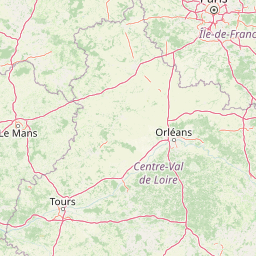
Use this park location map to pinpoint Réserve naturelle régionale du bassin de la Bièvre in France, understand its exact geographic position, and read its mapped placement within the surrounding landscape more clearly.

Pigeon | © OpenStreetMap contributors

Location context for Réserve naturelle régionale du bassin de la Bièvre

Île-de-France

Visual reference of wetland terrain, reedbeds, and urban-adjacent habitats

Réserve naturelle régionale du bassin de la Bièvre Photos and Mapped Landscape Scenery

Visual documentation captures the unique wetland terrain, open water zones, and dense reedbeds defining Réserve naturelle régionale du bassin de la Bièvre. Examining protected area imagery reveals how engineered urban hydrology supports rare avian habitats across the surrounding Parisian periphery.

A view through dense spring foliage of a calm wetland pond surrounded by trees and shrubs in the Bièvre Basin Nature Reserve.

A wooden birdwatching cabin with a small ramp leading up to its open door, situated in a wetland area.

Park atlas

Compare nearby regional reserves and wetland habitats across the surrounding Île-de-France region.

Parks Near Réserve Naturelle Régionale du Bassin de la Bièvre and Surrounding Protected Areas

Browsing nearby protected areas allows travelers to compare wetland habitats and urban nature reserves situated around the Bièvre valley. Expanding the geographic scope reveals additional regional landscapes sharing similar ecological profiles and conservation frameworks.
Nature reserveÎle-de-France
About 16 km away#1 closest

West

Réserve naturelle régionale du val et coteau de Saint-Rémy: Regional Nature Reserve Geography

A protected river valley and coteau habitat in Île-de-France

Spanning eighty-three hectares across five distinct parcels, this protected area serves as a vital ecological corridor along the Yvette river. Analyze the site's unique habitat distribution, ranging from moist bottomlands to dry, calcareous slopes, and trace its role in preserving regional biological diversity near Saint-Rémy-lès-Chevreuse.

Area
0.83 km²
Established
2008
IUCN
IV
Watercolor painting of a gentle, winding river or pond flowing through a green meadow with soft, rolling hills in the background under a pale sky.
Nature reserveÎle-de-France
About 24 km away#2 closest

Southwest

Réserve naturelle régionale des étangs de Bonnelles: Regional Nature Reserve Geography

Wetland ecosystem analysis in the Yvelines department.

Defined by its two core ponds, this regional nature reserve creates a critical mosaic of wetland, marsh, and woodland habitats. It stands out in the Île-de-France area as a concentrated zone of freshwater biodiversity, supporting a variety of avian and invertebrate life in a region where such undisturbed watery terrain is limited.

Area
0.221 km²
Established
1990
IUCN
IV
Relief
Lowland
A horizontal watercolor illustration showing a calm river winding around small tree-covered islands with low hills in the distance.
Nature reserveÎle-de-France
About 27 km away#3 closest

Northeast

Réserve naturelle régionale des îles de Chelles: Protected River Islands in Île-de-France

Wetland ecosystems and riparian landscape geography

Located on the Marne River, this protected regional nature reserve encompasses a series of river islands known for their rich wetland biodiversity. The site offers a unique geographic perspective on urban-adjacent conservation, featuring a mosaic of riparian thickets and hygrophilous flora that contrasts with the surrounding Seine-et-Marne landscape.

Area
0.05 km²
Established
2008
IUCN
IV
Relief
Lowland
A soft watercolor illustration depicting a serene landscape with rolling green fields, scattered deciduous trees, and a small meandering stream, set against a light, hazy background.
Nature reserveÎle-de-France
About 31 km away#4 closest

Southeast

Réserve naturelle régionale des bruyères de Sainte-Assise: Heathland Conservation Geography

A protected sandy heathland within the Île-de-France region

This reserve protects rare lowland heathland habitat on acidic soils within the Seine-et-Marne department. Spanning approximately 87 hectares near the Seine valley, the landscape is defined by heather and open vegetation. The site provides a vital sanctuary for biodiversity in a peri-urban setting, balancing conservation with its unique integration of historical land use and local geography.

Area
0.872 km²
Established
2009
IUCN
IV
Relief
Lowland
A pale, soft watercolor painting of a calm wetland or marsh, featuring muted green vegetation, light water reflection, and a gentle shoreline under a hazy sky.
Nature reserveÎle-de-France
About 38 km away#5 closest

North

Réserve naturelle régionale du marais de Stors: Atlas and Protected Landscape Overview

A rare wetland enclave in the Vallée de Chauvry

Focusing on the hydrological and ecological character of the Réserve naturelle régionale du marais de Stors, this overview examines its role as a protected nature reserve in the Paris region. Explore the marshland terrain and valley topography that define this unique pocket of conserved habitat in northern France.

Area
0.47 km²
Established
2009
IUCN
IV
Nature reserveÎle-de-France
About 45 km away#6 closest

Northwest

Réserve naturelle régionale du site géologique de Vigny-Longuesse: A Geological Reference Site

Protected limestone landscape in the Vexin region of Île-de-France

Protecting a critical paleontological and stratigraphic record, this reserve showcases a unique Tertiary reef complex. The site combines artificial quarry cliffs with natural geomorphological features, including paleolandslides and fossil-bearing limestone plates, providing a comprehensive outdoor archive of the Paris Basin.

Area
0.219 km²
Established
2009
IUCN
IV
Relief
Upland
Nature reserveÎle-de-France
About 48 km away#7 closest

Northwest

Réserve naturelle régionale du site géologique de Limay: Protected Landscapes and Geological Maps

A diverse nature reserve in the Yvelines department of Île-de-France.

Deeply rooted in the geological history of the Paris Basin, this former quarry site in Limay is now a thriving regional nature reserve. Its compact territory features a striking contrast between ancient limestone exposures and rich wetland pockets, providing a vital educational platform for studying biodiversity and land reclamation in north-central France.

Area
0.698 km²
Established
2009
IUCN
IV
Relief
Lowland
A horizontal watercolor illustration depicting a soft, light-toned marshy landscape with green trees, reeds, and rolling hills in the background.
Nature reserveÎle-de-France
About 56 km away#8 closest

Southeast

Réserve naturelle régionale du marais de Larchant: Protected Landscape and Map Context

Wetland ecosystems at the edge of the Gâtinais plateau

Located in the Seine-et-Marne department, this regional nature reserve features a dynamic calcareous marsh ecosystem shaped by the Gâtinais plateau scarp. The site serves as a vital hydrological nexus, providing essential habitats for waterbirds and wetland flora through cyclic aquifer-fed flooding and diverse terrain patterns.

Area
1.24 km²
Established
2008
IUCN
IV
Relief
Lowland

Common questions about visiting, size, designation, and location context for Réserve naturelle régionale du bassin de la Bièvre

Réserve naturelle régionale du bassin de la Bièvre FAQs for park facts, access, geography, and protected area context

Find quick answers about Réserve naturelle régionale du bassin de la Bièvre, including protected-area facts, park geography, trail and visitor context, and how the park fits into its surrounding country and regional landscape.
MoriAtlas Explorer

Continue Your Protected Areas Search Across the Global Atlas

Deepen your exploration by continuing the structured search for national parks and protected areas worldwide. Utilize the comprehensive filtering capabilities to compare different conservation landscapes and refine your understanding of global park geography. Discover more about the distribution and characteristics of protected natural areas.

Global natural geography