Mori Atlas logo
National parkParque nacional Río Negro-Sopladora

Analyzing the ecological vertical gradient from sub-Andean forests to pristine highland páramo

Parque nacional Río Negro-Sopladora: Mapping High-Elevation Andean Protected Landscapes in Ecuador

Parque nacional Río Negro-Sopladora stands as a significant protected area within the southern Ecuadorian Andes, bridging the provinces of Azuay and Morona Santiago. This atlas entry details its extensive elevational transition from 800-meter montane foothills to 3,900-meter páramo wetlands. The territory serves as a critical biological corridor within the broader Sangay-Podocarpus framework, maintaining a near-pristine mosaic of evergreen cloud forests and open highland grasslands essential for regional connectivity.

Andesparamomontane forestcloud forestwetlandsbiodiversity

Parque nacional Río Negro-Sopladora

National park

Park overview

Structured park overview, official facts, and landscape profile for Rio Negro-Sopladora National Park

Rio Negro-Sopladora National Park park facts, protected area profile, and essential visitor context

Review the core facts for Rio Negro-Sopladora National Park, including designation, size, terrain, visitor scale, habitats, and operating context in one park-focused overview.

About Rio Negro-Sopladora National Park

Río Negro-Sopladora National Park protects a substantial stretch of the southern Ecuadorian Andes where Andean forest and high-altitude páramo remain in close-to-natural condition. The park stretches across two provinces, Azuay and Morona Santiago, and connects the parishes of Amaluza in the canton of Sevilla de Oro with Copal in the canton of Santiago de Méndez. This regional position gives the park both highland and sub-Andean character, with landscapes ranging from steep cordillera slopes to open, wetland-rich páramo plateaus.

Designated in January 2018, the area became the 55th unit of Ecuador's National System of Protected Areas (SNAP). Its creation was driven by the recognition that the ecosystems within its borders are largely intact and that the area plays a critical bridging role between larger reserves nearby. The park both supplies and receives ecological flows from neighboring protected areas through the Sangay-Podocarpus conservation corridor, while also forming part of the broader Cóndor Kutukú-Palanda corridor, the first major connectivity corridor of its kind planned in Ecuador.

Ecologically, the park is dominated by two broad classes of habitat. Evergreen Andean forests of varying altitudinal bands cover the majority of the area and include piemontano, montano bajo, montano, and montano alto forest types of the southern Eastern Cordillera. Above the treeline, páramo grasslands with shrublands create a high-elevation mosaic that harbors wetlands, cushion-plant communities, and specialized flora. The elevational range, combined with abundant moisture, supports a striking variety of vascular plants, birds, amphibians, reptiles, and mammals documented during pre-establishment biological evaluations.

Beyond its biological richness, the park is significant for the cultural and ecological integrity of the region it occupies. Its forests influence local water cycles, and its highland systems help maintain the connectivity of the Andean-to-Amazonian gradient. By protecting intact páramo and forest at this scale, Río Negro-Sopladora contributes to the long-term resilience of southern Ecuador's protected-area network.

Quick facts and research context for Rio Negro-Sopladora National Park

Río Negro-Sopladora National Park is located in southern Ecuador, spanning the provinces of Azuay and Morona Santiago, and crosses the parishes of Amaluza in Sevilla de Oro canton and Copal in Santiago de Méndez canton. It was established on 23 January 2018 through Interministerial Agreement No. 009, becoming a national park under IUCN Category II and the 55th unit of Ecuador's SNAP.

The protected area covers just over 30,600 hectares, the vast majority of which lies in Morona Santiago. Its elevation spans roughly 800 to nearly 3,900 meters, producing transitions from lower montane forest up through cloud forest and into high-altitude páramo. The park's ecosystems fall within the Northern Andean Páramo and Eastern Cordillera Real montane forest ecoregions.

Protection and recognition

Examine documented terrestrial protection scope and management records

Parque nacional Río Negro-Sopladora Protection Status and Recognition

Parque nacional Río Negro-Sopladora maintains a documented terrestrial protection scope within the global conservation framework. Recorded records assemble official designation details, administrative management parameters, and international recognition data where available.

Protection details

Protection scope
Terrestrial
Transboundary protection
No
Park context

Deeper park guide and search-rich context for Rio Negro-Sopladora National Park

Rio Negro-Sopladora National Park history, landscape, wildlife, and travel context

Explore Rio Negro-Sopladora National Park through its history, landscape character, ecosystems, wildlife, conservation priorities, cultural context, and seasonal travel timing in a structured park guide built for atlas discovery and search intent.

Why Rio Negro-Sopladora National Park stands out

The park is best known for its extensive and largely undisturbed páramo and montane forest ecosystems, which together form a near-pristine Andean landscape at elevations between roughly 800 and 3,900 meters. Its forests and grasslands host a notable concentration of endemic plants and birds typical of the southern Eastern Cordillera of the Andes. It is also recognized for its role in regional connectivity. Río Negro-Sopladora anchors part of the Sangay-Podocarpus conservation corridor and lies within the Cóndor Kutukú-Palanda core area, making it a key link between protected landscapes in the Andes and the eastern Andean foothills.

Rio Negro-Sopladora National Park history and protected-area timeline

Río Negro-Sopladora National Park was officially created on 23 January 2018 through Interministerial Agreement No. 009, formalizing its designation as a national park under Ecuador's protected-area framework. The establishment followed a multi-investigator biological assessment completed in 2017, which documented the area's vegetation cover, species composition, and conservation significance.

The park's creation also completed an important step in Ecuador's landscape-scale conservation planning. By designating this area, the authorities extended the national system of protected areas and reinforced the role of the Sangay-Podocarpus connectivity corridor. Within that framework, the park lies inside one of the four core areas of the Cóndor Kutukú-Palanda corridor, recognized as the first major connectivity corridor designed in Ecuador. The park therefore emerged not just as an isolated reserve, but as part of a deliberate network intended to maintain ecological flows between Andean uplands and lower eastern Andean landscapes.

Since its designation, Río Negro-Sopladora has been administered under the Ministry of Environment and Water (MAAE) within the SNAP structure, continuing the country's approach of managing high-priority ecosystems through national-level coordination.

Rio Negro-Sopladora National Park landscape and geographic character

The landscape of Río Negro-Sopladora is defined by a steep Andean gradient. The park covers an elevational range from roughly 800 meters in its lower eastern reaches to nearly 3,900 meters along its highest ridges. This dramatic vertical change produces a transition from sub-Andean foothills up through increasingly moist montane forests, then into open páramo on the highest plateaus.

Geologically and ecologically, the territory belongs to the southern Eastern Cordillera of the Andes, with deeply dissected slopes, narrow valleys, and ridges that funnel water into the Río Negro and Sopladora basins. Above the main forest belt, the terrain opens into high-elevation páramo plains where wetlands, cushion-plant vegetation, and shrubby mosaics shape a landscape that feels starkly different from the forested slopes below.

The variation in altitude, slope orientation, and moisture produces a patchwork of forest subtypes across the park, from piemontano forests at lower elevations to the high-altitude montano alto cloud forest types near the treeline. The result is a landscape of continuous ecological transition, where dense evergreen forest gives way to open grassland and where elevation, slope, and humidity jointly determine what grows and what survives.

Rio Negro-Sopladora National Park ecosystems, habitats, and plant life

Ecologically, Río Negro-Sopladora is structured around two interlocking systems: evergreen Andean forest and high-altitude páramo. Together, these ecosystems occupy the overwhelming majority of the park's surface, and their distribution follows elevation closely.

Andean forest is the dominant ecosystem, covering roughly two-thirds of the park. Within this broad forest class, several altitudinal subtypes occur, ranging from piemontano forests at lower elevations through montano bajo, montano, and montano alto forests higher up. Each band supports distinct vegetation compositions and microclimates, creating layered habitats along the steep slopes of the Eastern Cordillera.

Above the forest limit, páramo occupies the highest terrain. This ecosystem forms a mosaic of herbaceous páramo grasslands and evergreen shrublands, interspersed with wetlands and localized patches where soils stay saturated year-round. The combination of varied habitats and unstable, moisture-rich highland conditions creates refugia for specialized plant species, including endemic and restricted-range taxa that are often vulnerable to disturbance elsewhere in the Andes.

Rio Negro-Sopladora National Park wildlife and species highlights

Wildlife in Río Negro-Sopladora reflects the diversity of its habitats, with documented records spanning birds, amphibians, reptiles, and mammals. The park has recorded around 136 bird species, including several endemics such as Cinnamon Screech-Owl (Megascops petersoni), Coppery-chested Jacamar (Galbula pastazae), Crescent-faced Antpitta (Grallaricula lineifrons), Chusquea Tapaculo (Scytalopus parkeri), Mouse-colored Thistletail (Asthenes griseomurina), Black-breasted Fruiteater (Pipreola lubomirskii), and Black-backed Bush-Finch (Urothraupis stolzmanni). Several of these are restricted to narrow ranges in the Andes and represent a key conservation priority for the park.

In the herpetofauna, the park hosts around 23 recorded species of amphibians and reptiles, many of them endemic to the southern Ecuadorian Andes and surrounding foothill forests. Notable records include Pristimantis balionotus, Lepidoblepharis festae, Alopoglossus buckleyi, Anolis fitchi, and Synophis zamora, the last being a snake endemic to the Amazonian slopes of the southeastern Andes.

Mammal diversity is also substantial, with around 43 species documented, including Andean Bear (Tremarctos ornatus), Mountain Tapir (Tapirus pinchaque), Andean White-tailed Deer (Odocoileus ustus), Puma (Puma concolor), White-lipped Peccary (Tayassu pecari), Northern Tiger Cat (Leopardus tigrinus), Andean Weasel (Nasuella olivacea), Mountain Paca (Cuniculus taczanowskii), Andean Cottontail (Sylvilagus andinus), and Caenolestes sangay, a rare marsupial. The presence of large mammals and rare species underscores the park's role as a refuge for wildlife that is increasingly pressured elsewhere in the Andes.

Rio Negro-Sopladora National Park conservation status and protection priorities

Río Negro-Sopladora holds a central conservation role within southern Ecuador. Its ecosystems remain nearly intact, which is unusual in a region where Andean forests and páramos have historically faced heavy pressure from agriculture, grazing, and burning. The site's condition makes it a critical source area for Andean biodiversity and an important reservoir of genetic and ecological diversity for the surrounding landscape.

The park is also a cornerstone of regional connectivity. As part of the Sangay-Podocarpus corridor and one of the four core areas of the Cóndor Kutukú-Palanda corridor, it sustains biological flows between highland páramos and the eastern Andean foothills. This functional role, linking protected environments across elevation and ownership, gives the park a conservation weight that extends well beyond its own borders.

The high concentration of endemic and threatened species within a relatively compact area reinforces this importance. Many of the plant species recorded are nationally endemic, and a substantial share of the documented flora falls into some category of national threat. Combined with the presence of sensitive mammals and amphibians, this profile positions the park as a priority site for long-term biodiversity protection in Ecuador.

Rio Negro-Sopladora National Park cultural meaning and human context

The cultural context of the park reflects its rural Andean setting, where traditional land use has long intersected with forests and páramos in the Azuay and Morona Santiago highlands. The protected area crosses parishes that are deeply tied to agricultural and pastoral traditions, and its creation reflects an evolving relationship between local communities, regional governments, and the national conservation system.

The park also contributes to regional identity through its role within long-standing conservation initiatives, including the Sangay-Podocarpus corridor and the Cóndor Kutukú-Palanda connectivity framework, both of which emphasize cooperative stewardship across multiple jurisdictions. While the park itself is primarily valued for its ecological integrity, its establishment reinforces a broader narrative of mountain landscapes as shared cultural and natural heritage in southern Ecuador.

Top sights and standout views in Rio Negro-Sopladora National Park

The most distinctive feature of Río Negro-Sopladora is its near-pristine condition: large expanses of Andean forest and páramo that still preserve their ecological structure with little modification. Within this setting, the park offers dramatic transitions from sub-Andean forest to high páramo in a relatively compact geographic footprint.

Equally important is the park's place within a connectivity network. Through the Sangay-Podocarpus corridor and the Cóndor Kutukú-Palanda core area, it functions as a living bridge for wildlife moving between Andean highlands and the eastern foothills. For conservation-minded visitors, researchers, and regional planners, this combination of integrity and connectivity makes Río Negro-Sopladora a standout among Ecuador's newer protected areas.

Best time to visit Rio Negro-Sopladora National Park

Given its high Andean setting, the park's character shifts meaningfully between drier and wetter seasons. Drier months generally offer clearer skies, better views of high-elevation páramo, and easier access on foot through forest and grassland landscapes. This period is also typically favorable for birdwatching, when many Andean species are most detectable along forest edges and páramo margins.

Wetter months bring more cloud cover, frequent mist in the montane forests, and saturated páramo wetlands. While conditions can be muddier and visibility more limited, the forest is at its lushest and many amphibians become more active. Travelers interested in the ecological atmosphere of cloud forest and páramo ecosystems often find this season rewarding, even though access can be more demanding. As always in high-Andean terrain, conditions vary year to year, and flexible planning helps accommodate local weather shifts.
Monthly climate preview

Long-term temperature ranges and monthly precipitation recorded at representative park coordinates

Parque nacional Río Negro-Sopladora Climate Normals and Annual Weather Patterns

Representative coordinates record measured monthly temperature swings and precipitation averages across the protected terrain. Detailed twelve-month climate profiles provide comprehensive long-term statistical context for this high elevation park.
Annual mean12 °C
10 °C12 °C
Jan12°
Feb12°
Mar12°
Apr12°
May12°
Jun11°
Jul10°
Aug10°
Sep11°
Oct12°
Nov12°
Dec12°
Warmest month
December

12.3 °C

Coolest month
July

10.3 °C

Wettest month
March

4.7 mm/day

Driest month
August

2.1 mm/day

Park location guide

Geography guide, regional context, and park location map for Rio Negro-Sopladora National Park

Rio Negro-Sopladora National Park park geography, regions, and map view in Ecuador

Understand where Rio Negro-Sopladora National Park sits in Ecuador through a broader geographic reading of the surrounding landscape, nearby location context, and its mapped position within the national park landscape.

How Rio Negro-Sopladora National Park fits into Ecuador

Ecuador is a presidential republic located in northwestern South America, with Quito as its capital and Guayaquil as its largest city. The country spans 283,561 km² and encompasses the Galápagos Islands, a volcanic archipelago famous for unique wildlife that helped shape Darwin's theory of evolution. Ecuador is a plurinational state with Spanish as the official language, though Kichwa and Shuar are recognized for indigenous peoples.

Wider geography shaping Rio Negro-Sopladora National Park in Ecuador

Ecuador is located in northwestern South America along the Pacific coast. It shares borders with Colombia to the north and Peru to the east and south. The country includes the Galápagos Islands, a volcanic archipelago in the Pacific Ocean approximately 1,000 km west of the mainland. The territory encompasses diverse terrain including the Amazon rainforest in the east, the Andean highlands in the center, and coastal plains along the Pacific.

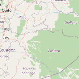
Map view of Rio Negro-Sopladora National Park

Use this park location map to pinpoint Rio Negro-Sopladora National Park in Ecuador, understand its exact geographic position, and read its mapped placement within the surrounding landscape more clearly.

Pigeon | © OpenStreetMap contributors

Location context for Rio Negro-Sopladora National Park

AzuayMorona Santiago
Recorded earthquake history

View the Recorded Earthquake History for Parque nacional Río Negro-Sopladora

Access the comprehensive list of seismic events associated with the location of Parque nacional Río Negro-Sopladora. Review historical records including magnitudes and epicentre proximity to understand the documented seismic context of the southern Andean region through a curated data collection.

Parque nacional Río Negro-Sopladora earthquake records

Catalogued events

50 events

Strongest magnitude

Magnitude 5.7

Most recent event

Nov 24, 2024

This history includes earthquakes recorded inside the park or within 50 km of its borders

Park atlas

Compare adjacent highland reserves and connected Andean conservation corridors

Parks near Parque nacional Río Negro-Sopladora and surrounding protected areas

Browse nearby national parks and protected areas sharing similar high-elevation Andean terrain and montane forest ecosystems. Comparing adjacent reserves reveals broader regional connectivity patterns across the southern Eastern Cordillera.
Watercolor illustration showing a mountain landscape with a snow-capped peak, a lake, and green hills.
National parkEcuador
0.4 km away#1 closest

North

Sangay National Park: Ecuador's National Park for Mapped Landscape and Geographic Discovery

Explore Ecuador's protected area boundaries and regional terrain.

Sangay National Park serves as a crucial protected landscape within Ecuador, offering rich opportunities for atlas and geography exploration. This page details the park's specific mapped boundaries and its natural terrain, providing essential context for understanding its place within South America's broader geographic tapestry. Investigate Sangay National Park's identity as a protected national park and its value for focused landscape and regional discovery.

Area
5,177.65 km²
Established
1979
IUCN
II
Watercolor painting of a mountain landscape with a lake, rolling hills, and coniferous trees in soft green and yellow tones.
National parkAzuay
59 km away#2 closest

West

Parque nacional Cajas: Mapping the Glacial Lakes and Paramo of the Ecuadorian Andes

Geographic analysis of high-elevation protected lands

Parque nacional Cajas encompasses a rugged, glacial-sculpted plateau characterized by cushion vegetation, boggy wetlands, and frequent fog. This protected area offers deep insight into the highland Andean geography of Azuay, where water bodies and mountain ridges intersect to form an essential ecological and cultural corridor for the region.

Area
293.89 km²
Established
1977
IUCN
II
Visitors
53K annual
Nature reserveMorona Santiago
59 km away#3 closest

South

Reserva biologica El Quimi: Protected Andean Watersheds and Cordillera del Condor Geography

A rugged nature reserve defined by complex metamorphic and volcanic mountain terrain.

Reserva biologica El Quimi guards the headwaters of the Quimi River along a strategically positioned watershed divide. Located in the province of Morona Santiago, this reserve features steep forested slopes and high plateau edges. Its varied geological foundation contributes to the broader regional ecological network, serving as a sanctuary for diverse mammal species including the Andean bear and jaguar.

Area
90.24 km²
Established
2006
Relief
Mountain
Climate
Subtropical
National parkEcuador
About 67 km away#4 closest

West

El Cajas National Park National Park: Ecuador's Protected Landscape Geography and Map Context

Explore the mapped protected areas and regional geography of El Cajas National Park.

El Cajas National Park is a protected national park in Ecuador, serving as a focal point for atlas-driven geographic exploration. This page provides detailed insight into the park's mapped boundaries and its significance as a protected natural landscape within Ecuador's broader geography. Understand the context of El Cajas National Park for structured discovery of protected lands and natural terrains across South America.

National parkPeru
About 71 km away#5 closest

Southeast

Ichigkat Muja, Cordillera del Cóndor National Park: Peru's National Park Geography and Mapped Boundaries

Explore its protected landscape and regional geographic context.

This detail entry focuses on Ichigkat Muja, Cordillera del Cóndor National Park, a designated national park in Peru. It provides essential information for understanding the park's geography, its protected landscape features, and its mapped extent. Users can explore this park's unique geographic identity and its place within the broader atlas of Peru's natural protected areas, offering a factual foundation for geographic research.

Area
884.77 km²
Established
2007
Relief
Mountain
Climate
Tropical
Wildlife reserveZamora Chinchipe
96 km away#6 closest

South

Refugio de vida silvestre El Zarza: Mapping Protected Lands in Zamora Chinchipe

Andean-Amazonian transition and sandstone tepuy habitats

Refugio de vida silvestre El Zarza serves as a critical conservation zone where the volcanic and metamorphic rocks of the Andes meet the sandstone formations of the Amazonian fringe. Explore the varied morphology of this wildlife refuge, which encompasses rounded ridges, steep river canyons, and pale, stratified farallones that define the eastern sector of the Cordillera del Condor.

Area
36.96 km²
Established
2006
IUCN
Ia
Relief
Mountain
A pale, soft watercolor painting showing a stylized, rolling landscape with light green, pink, and yellow hues representing hills and trees.
Nature reserveGuayas Province
111 km away#7 closest

West

Reserva ecológica Manglares Churute: Mapping a Coastal Nature Reserve in Guayas Province

An ecological mosaic of mangrove forests, estuaries, and forested ridges.

Spanning from the inner Gulf of Guayaquil into the Churute hill range, Reserva ecológica Manglares Churute acts as an essential protected area within Ecuador. The region contains one of the country's most significant mangrove complexes, complemented by freshwater lagoons and unique fog-affected forest summits that support diverse wildlife populations and endemic vegetation.

Area
471.74 km²
Established
1979
IUCN
Ia
Relief
Mixed relief
A soft watercolor painting of a hilly, grassy landscape with distant mountains in muted greens and pinks.
Wildlife reserveChimborazo
124 km away#8 closest

North

Reserva de Producción de Fauna Chimborazo: Volcanic Landscapes and Andean Wildlife Reserve

High-altitude watershed and páramo geography in central Ecuador.

Spanning from glacial summits to arid puna plains, the Reserva de Producción de Fauna Chimborazo represents a complex Andean ecosystem. This wildlife reserve protects vital watersheds, glacial meltwater sources, and native camelid habitats within the shadows of Ecuador's tallest peaks, offering a detailed look at high-altitude conservation and volcanic terrain.

Area
526.83 km²
Established
1987
IUCN
IV
Relief
Mountain

Common questions about visiting, size, designation, and location context for Rio Negro-Sopladora National Park

Rio Negro-Sopladora National Park FAQs for park facts, access, geography, and protected area context

Find quick answers about Rio Negro-Sopladora National Park, including protected-area facts, park geography, trail and visitor context, and how the park fits into its surrounding country and regional landscape.
MoriAtlas Explorer

Continue Your Protected Areas Search Across the Global Atlas

Deepen your exploration by continuing the structured search for national parks and protected areas worldwide. Utilize the comprehensive filtering capabilities to compare different conservation landscapes and refine your understanding of global park geography. Discover more about the distribution and characteristics of protected natural areas.

Global natural geography