
Mori Atlas logo
Nature reserveRiserva naturalistica dell'Adelasia

A vital protected woodland refuge situated along the northern slopes of the Ligurian Apennines

Riserva naturalistica dell'Adelasia: Geographic Atlas and Protected Nature Reserve Landscape in Liguria, Italy

Riserva naturalistica dell'Adelasia preserves a significant tract of mixed beech and chestnut woodland within the upper Bormida valley of Liguria. Situated near the historic divide between the Alps and the Apennines, this protected landscape features varied terrain ranging from stream-cut valleys to the prominent rocky spur of the Rocca dell'Adelasia. The area serves as an essential green lung, offering a detailed glimpse into the intersection of mature forest ecosystems and industrial-era regional history.

Ligurian ApenninesBeech forestChestnut forestDeciduous woodlandWildlife refugeGreen lung
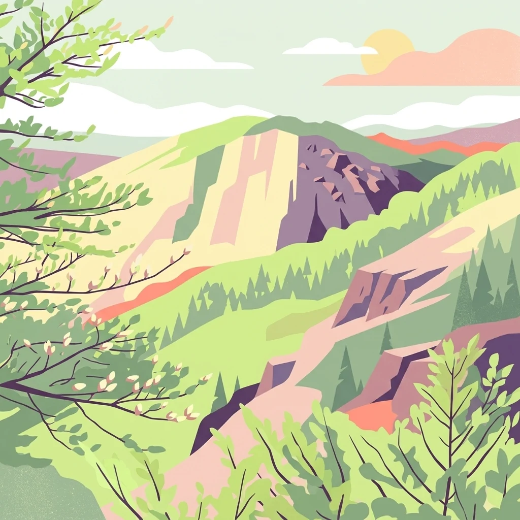
A digital illustration featuring a green, hilly landscape with rocky outcrops, forested slopes, and a soft sun in the sky.

Riserva naturalistica dell'Adelasia

Nature reserve

Park overview

Structured park overview, official facts, and landscape profile for Riserva naturalistica dell'Adelasia

Riserva naturalistica dell'Adelasia park facts, protected area profile, and essential visitor context

Review the core facts for Riserva naturalistica dell'Adelasia, including designation, size, terrain, visitor scale, habitats, and operating context in one park-focused overview.

About Riserva naturalistica dell'Adelasia

The Riserva naturalistica dell'Adelasia occupies a transitional zone of the Ligurian Apennines, where the mountains drop toward the Bormida di Millesimo and Bormida di Spigno valleys. Although the Ligurian Sea lies relatively close to the west, the reserve's climate is essentially Po Valley continental in character: winters can drop well below freezing, especially when the tramontana wind sweeps through, and summers are warm but generally mild. This continental feel, combined with elevation, supports beech forest at the highest levels, an unusual sight so close to the Mediterranean coast.

Ecologically, the reserve functions less as a remote wilderness and more as a vital refuge. The upper Bormida valley has hosted chemical, photographic and other industrial operations for much of the twentieth century, and at peak pollution periods the air quality and aquatic life suffered. The woodland block preserved around the Rocca dell'Adelasia, together with the closure of several polluting plants, has allowed ecosystems to recover: native crayfish have returned to the streams, forest mammals have rebounded, and the wooded corridor is slowly expanding into neighbouring parts of the province of Savona.

The reserve is also a place of recreational and educational value. Trails cross the wooded slopes, the ridge at Bric del Tesoro offers panoramic views across the Bormida valley, and the restored Cascina Miera at about 770 meters, close to the Altare to Montenotte road, serves as a mountain refuge. Visitors encounter a landscape that mixes natural forest, industrial heritage in the valley below, layered local history, and the medieval resonance of the Adelasia and Aleramo story that gives the Rocca its name.

In broader terms, the reserve represents a model of corporate-led conservation that turned an industrial liability into a long-term ecological asset. Although modest in size compared to major Italian national parks, its position in a densely populated and heavily industrialized Alpine-Apennine border zone makes it disproportionately valuable for biodiversity, air quality and regional ecological connectivity.

Quick facts and research context for Riserva naturalistica dell'Adelasia

The Adelasia reserve lies in the upper Val Bormida, on the northern face of the Ligurian Apennines east of the Colle di Cadibona. It is administered at regional level in Liguria, province of Savona, and falls within the territory of Cairo Montenotte. The reserve was established in 1989 on land contributed by 3M Italia, through its subsidiary Ferrania Imaging Technologies, to offset the environmental footprint of its historic film and imaging operations in the valley.

The protected area spans altitudes from roughly 400 to about 860 meters, with the summit at Bric del Tesoro, and features beech forest at higher elevations, chestnut woods lower down, and replanted stands of Norway spruce and black pine. It functions as both a biodiversity reserve and an environmental recovery zone for a valley long shaped by industrial activity, and includes the restored Cascina Miera mountain hut at around 770 meters near the Altare to Montenotte road.

Protection and recognition

Explore terrestrial conservation scope and official designation records

Riserva naturalistica dell'Adelasia Protection Status and Recognition

Documented protection records outline the terrestrial conservation scope and management framework established for Riserva naturalistica dell'Adelasia. Verified designation details and administrative data provide a clear baseline for understanding the protected area landscape.

Protection details

Protection scope
Terrestrial
Transboundary protection
No
Park context

Deeper park guide and search-rich context for Riserva naturalistica dell'Adelasia

Riserva naturalistica dell'Adelasia history, landscape, wildlife, and travel context

Explore Riserva naturalistica dell'Adelasia through its history, landscape character, ecosystems, wildlife, conservation priorities, cultural context, and seasonal travel timing in a structured park guide built for atlas discovery and search intent.

Why Riserva naturalistica dell'Adelasia stands out

The reserve is best known for being one of the rare mature woodland tracts remaining in the heavily industrialized upper Bormida valley, serving as a 'green lung' that has helped local air and water quality recover. Its beech and chestnut forests, mixed with Norway spruce and black pine replantations, support a surprisingly rich community of mammals and birds in a relatively compact area. It is also known for the Rocca dell'Adelasia, the rocky spur at about 698 meters that gives the reserve its name, and for the legend of Adelasia and Aleramo, a foundational story of the Monferrato and Ligurian borderlands. Combined, the ecological role and the romantic local heritage give the reserve a strong identity that distinguishes it from typical inland Ligurian woodlands.
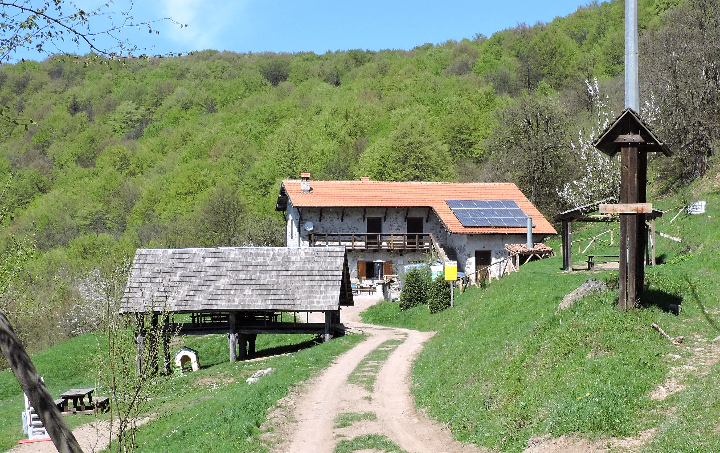
A stone farmhouse with a terracotta roof, solar panels, and an adjacent open-sided wooden structure, nestled in a green valley in the Adelasia Nature Reserve.
Miera Farmhouse, a historic building situated within the Adelasia Nature Reserve.

Riserva naturalistica dell'Adelasia history and protected-area timeline

The reserve has its origins in the industrial history of Ferrania, a small town in the Cairo Montenotte area that became the home of the Italian film and imaging industry. Ferrania Imaging Technologies, part of the 3M group, operated there for much of the twentieth century, and in 1989 the company set aside several hundred hectares of forested land around the Rocca dell'Adelasia as a contribution to the preservation of the natural environment in the area.

That 1989 act of protection came at a time when the upper Bormida valley was grappling with the cumulative effects of decades of industrial activity. Air quality in the valley had deteriorated over the previous century, and heavy pollution episodes had reduced local fauna. The decision effectively transformed part of the company's property into a permanent natural reserve, with management passing to the province of Savona.

Over the following decades, the reserve's ecological role expanded. With the closure or reduction of several polluting industrial facilities and gradual improvements in air and water quality, the woodland began functioning as a vital 'green lung' for the valley. Native aquatic species, including the freshwater crayfish, returned to the Bormida streams, and the reserve's small but stable ecosystem started to spread into neighbouring wooded areas of the province of Savona, reinforcing the original conservation investment.

Riserva naturalistica dell'Adelasia landscape and geographic character

Geographically, the reserve sits on the northern flank of the Ligurian Apennines, just east of the Colle di Cadibona, more precisely the Bocchetta di Altare at 459 meters, the traditional geographical divide between the Apennine and Alpine systems. From this threshold position, the protected slopes climb through a wide altitudinal band between roughly 400 and 860 meters, with Bric del Tesoro at 860.3 meters marking the highest point.

Terrain within the reserve is varied and visually striking. The Rocca dell'Adelasia at about 698 meters rises as a prominent rocky spur above the forest canopy and serves as both a landmark and the reserve's namesake feature. Around it, the slopes alternate between gentler wooded ridges, steeper rock faces and narrow stream-cut valleys. The cascading streams that run through the reserve shape small gorges and create the humid microhabitats that sustain amphibians and stream-loving birds.

From the higher ridges, views open across the wider Bormida valley, with its mix of villages, terraced fields and former industrial installations, providing a sharp visual contrast between the wooded reserve and the more heavily modified valley below. The restored Cascina Miera, at around 770 meters on the road between Altare and Montenotte, sits as a human-scale focal point within the otherwise forested landscape.
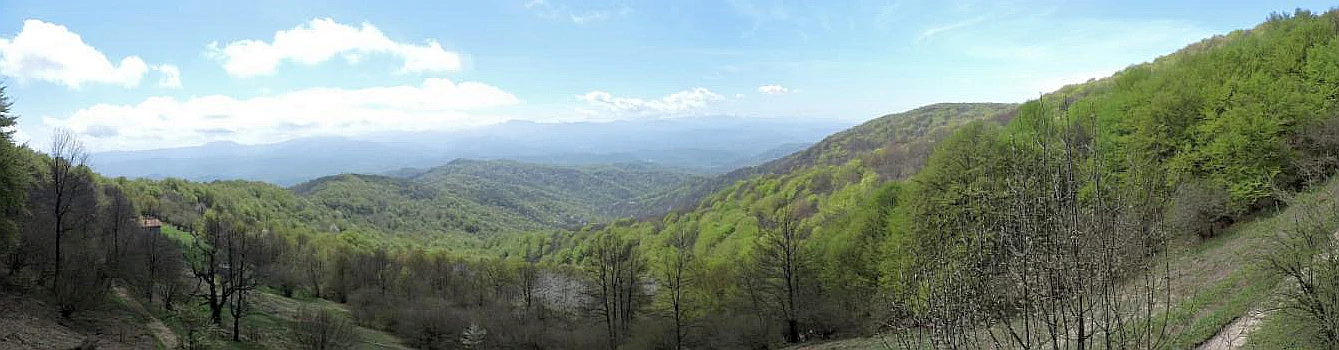
Wide panoramic view of green forested rolling hills and mountain ridges under a blue sky.
Panoramic view of the forested hills within the Riserva naturalistica dell'Adelasia.

Riserva naturalistica dell'Adelasia ecosystems, habitats, and plant life

Vegetation in the reserve is layered according to elevation and exposure. The upper slopes carry beech forest, a notably continental-influenced feature given the reserve's position only a short distance from the Ligurian coast. Lower elevations are dominated by chestnut, including both coppice and fruit-producing stands, along with hazel, sessile oak and holm oak in drier pockets. Alder colonises wetter zones along the streams, while broom and a wide range of other tree and shrub species enrich the understorey.

Planted Norway spruce and black pine stands reflect twentieth-century reforestation efforts and contribute to the current mosaic of forest types. Among the more noteworthy flowering plants, the orange lily, sometimes called the lily of Saint John, occurs in the reserve, and the rarer Turk's cap lily has also been recorded, adding seasonal botanical interest to the woodland.

The combination of elevation, continental climate, stream systems and varied forest cover produces a habitat mosaic that supports a richer fauna than the reserve's compact size might suggest. This mosaic is the reason the reserve has served as a stepping stone for ecological recovery in the wider valley.

Riserva naturalistica dell'Adelasia wildlife and species highlights

Mammals are well represented within the protected forest. Roe deer browse the understorey and forest edges, while wild boar root through the leaf litter, particularly in chestnut-dominated areas. Red foxes and Eurasian badgers are active across the slopes, and the edible dormouse, a typical resident of mature broadleaf and mixed forests, also occurs here. Polecats add to the carnivore community that thrives in this mosaic of habitats.

The reserve is notable for its birdlife, which spans both forest and stream species. Green woodpeckers work the trunks and open clearings, while grey wagtails frequent the streams. Raptors such as common kestrels, Eurasian sparrowhawks and little owls hunt along the forest edges and open ridges, giving the reserve a strong raptor presence for its size.

Aquatic and riparian habitats host their own distinctive community. White-throated dippers forage along the fast-flowing streams, grass snakes glide through the wet margins, and kingfishers as well as grey herons occasionally visit the watercourses. Fire salamanders breed in the moist valleys, and common frogs populate the edges of pools and slow-moving sections of the streams, confirming that the Bormida's waterways have largely recovered their ecological function.

Riserva naturalistica dell'Adelasia conservation status and protection priorities

From a conservation perspective, the reserve's significance lies in its position within one of the most industrialized valleys of north-western Italy. Surrounding the Bormida basin, chemical, metallurgical and photographic industries operated for over a century, and the cumulative environmental pressure on air, water and biological communities was severe. The 1989 creation of the reserve represented a deliberate effort to anchor a large block of forest that could act as a refuge, a biological corridor and a buffer against further ecological decline.

Its role as a 'green lung' for the upper Bormida is now central to its conservation identity. Over the past three decades, as polluting facilities have been closed or restructured, air quality in the valley has improved measurably, and the reserve has helped mediate and accelerate that recovery. Water quality has also rebounded to the point where sensitive aquatic species, including native freshwater crayfish, have recolonised some stretches of the Bormida's tributary streams.

The reserve's management, originally industrial and now provincial through the province of Savona, has also allowed the local ecosystem to expand. The wooded corridor around the Rocca dell'Adelasia is gradually extending into neighbouring forests of the Savona province, demonstrating how an initial protected nucleus can drive ecological recovery well beyond its formal boundaries. As such, the Adelasia reserve is a working example of how targeted woodland protection in an industrial setting can translate into broader regional environmental gain.

Riserva naturalistica dell'Adelasia cultural meaning and human context

The reserve's most prominent cultural reference is the legend of Adelasia and Aleramo, a foundational tale in the medieval history of this borderland between Liguria and the Monferrato. According to tradition, Adelasia, daughter of Otto, found refuge at the rocky spur now known as the Rocca dell'Adelasia, where she met Aleramo, later the first marquess of Monferrato. The reserve, and especially its iconic rock, still carries this romantic narrative as part of its identity.

In the twentieth century, the reserve's cultural meaning expanded with the industrial heritage of Ferrania. The land was donated by 3M Italia through Ferrania Imaging Technologies, tying the reserve's existence to the history of Italian photographic and imaging industry. This origin story makes the reserve an unusual meeting point of medieval legend and modern industrial landscape.

The restored Cascina Miera, a traditional stone mountain farmhouse at about 770 meters, adds an agricultural and pastoral dimension to the reserve's cultural layer. Once used by local herders and farmers, it now serves as a refuge and meeting point for visitors, anchoring the landscape in the rural heritage of the upper Bormida valleys.

Top sights and standout views in Riserva naturalistica dell'Adelasia

The Rocca dell'Adelasia at roughly 698 meters is the reserve's defining landmark, both visually and culturally, and is the focal point of the woodland around it. The summit ridge at Bric del Tesoro, at about 860 meters, offers the highest vantage point and panoramic views across the upper Bormida valley.

The mixed beech and chestnut forest, interspersed with replanted Norway spruce and black pine, is unusually diverse for an area so close to the Ligurian coast, and gives the reserve an unusually continental ecological tone. The restored Cascina Miera at around 770 meters serves both as a practical mountain refuge and as a tangible reminder of the valley's traditional rural economy.

Best time to visit Riserva naturalistica dell'Adelasia

Spring and early summer are particularly rewarding in the reserve, when the chestnut foliage is fully out, wildflowers such as the orange lily are at their peak, and streams are fed by snowmelt and seasonal rains. The fresh green forest cover and active birdlife make this the most visually lively period.

Autumn brings a second highlight, with chestnut harvest traditionally underway and the mixed forest taking on warm russet tones, while still offering mild temperatures for walking. Winter visits are possible, but worth noting that the reserve's continental climate means temperatures can drop sharply, especially under tramontana wind, with occasional readings well below minus ten degrees Celsius, so conditions are harsher than the nearby coast.


Monthly climate preview

Long-term temperature ranges and precipitation rhythm across twelve recorded intervals

Riserva naturalistica dell'Adelasia Climate Normals and Monthly Weather Patterns

Representative coordinate records show mean monthly temperatures ranging from 1.89 degrees Celsius in January to 23.4 degrees Celsius in July alongside daily precipitation rates between 1.17 and 3.92 millimeters. Reviewing the complete monthly climate normals for Riserva naturalistica dell'Adelasia reveals full temperature extremes and precipitation distributions across the entire annual cycle.
Annual mean12 °C
2 °C23 °C
Jan
Feb
Mar
Apr11°
May15°
Jun20°
Jul23°
Aug23°
Sep18°
Oct12°
Nov
Dec
Warmest month
July

23.4 °C

Coolest month
January

1.9 °C

Wettest month
November

3.9 mm/day

Driest month
July

1.2 mm/day

Park location guide

Geography guide, regional context, and park location map for Riserva naturalistica dell'Adelasia

Riserva naturalistica dell'Adelasia park geography, regions, and map view in Italy

Understand where Riserva naturalistica dell'Adelasia sits in Italy through a broader geographic reading of the surrounding landscape, nearby location context, and its mapped position within the national park landscape.

How Riserva naturalistica dell'Adelasia fits into Italy

Italy is a unitary parliamentary republic in Southern and Western Europe, located on the Italian Peninsula with the Alps to the north. It borders France, Switzerland, Austria, Slovenia, Vatican City, and San Marino, and shares maritime boundaries with several Mediterranean countries. The country has approximately 59 million residents and uses the Euro as its currency.

Wider geography shaping Riserva naturalistica dell'Adelasia in Italy

Italy occupies a boot-shaped peninsula in southern Europe, bordered by the Alps to the north. It shares land borders with France, Switzerland, Austria, Slovenia, Vatican City, and San Marino. The country includes the Mediterranean islands of Sicily and Sardinia, along with approximately 800 smaller islands.

Map view of Riserva naturalistica dell'Adelasia

Use this park location map to pinpoint Riserva naturalistica dell'Adelasia in Italy, understand its exact geographic position, and read its mapped placement within the surrounding landscape more clearly.

Pigeon | © OpenStreetMap contributors

Location context for Riserva naturalistica dell'Adelasia

Liguria
Recorded earthquake history

Examine the Recorded Seismic History of Riserva naturalistica dell'Adelasia

Consult the historical earthquake catalogue associated with the Ligurian Apennine landscape surrounding Riserva naturalistica dell'Adelasia. MoriAtlas provides detailed access to recorded event dates and magnitudes for those interested in the regional seismic geography and historical environmental data.

Riserva naturalistica dell'Adelasia Earthquake History

Catalogued events

104 events

Strongest magnitude

Magnitude 4.7

Most recent event

Nov 14, 2013

This history includes earthquakes recorded inside the park or within 50 km of its borders

Visual exploration of the rocky spurs, mixed beech forests, and Apennine ridge habitats.

Riserva naturalistica dell'Adelasia Photos: Scenery, Woodlands, and Protected Landscapes

Photographic records capture the dense woodland canopy, rocky elevation outcrops, and stream carved gorges defining the protected terrain of Riserva naturalistica dell'Adelasia. Visual documentation provides direct insight into the mature forest ecosystems and regional geography shaping the upper Bormida valley.

A stone farmhouse with a terracotta roof, solar panels, and an adjacent open-sided wooden structure, nestled in a green valley in the Adelasia Nature Reserve.

A distant, rounded mountain peak, identified as Rocca dell'Adelasia, covered in sparse, early-season forest with rocky patches, seen over a foreground of blurred tree branches.

Wide panoramic view of green forested rolling hills and mountain ridges under a blue sky.

Park atlas

Compare adjacent Ligurian Apennine reserves and surrounding regional woodland geography

Other Protected Areas and Parks Near Riserva naturalistica dell'Adelasia

Browsing parks near Riserva naturalistica dell'Adelasia reveals a wider network of protected upland forests, transitional ridge habitats, and river valleys spanning the regional borderlands. Evaluating these adjacent natural reserves provides deeper context into the diverse conservation landscapes and woodland ecosystems characterizing northwestern Italy.
Marine protected areaFrance
11 km away#1 closest

South

Sanctuaire Pelagos Marine Protected Area: Mediterranean Geography and Seascape

A transboundary conservation zone spanning 87,500 square kilometers.

Sanctuaire Pelagos represents a unique collaborative effort in marine conservation across the Mediterranean. Spanning the waters between France, Italy, and Monaco, this protected maritime area is defined by its deep-sea canyons and nutrient-rich currents that sustain diverse cetacean populations. Its immense scale and international governance make it a focal point for understanding Mediterranean marine biodiversity and environmental policy.

Area
87,500 km²
Established
1999
IUCN
IV
Relief
Lowland
Watercolor illustration of a mountainous landscape featuring a river, rolling hills, and green vegetation
National parkFrance
71 km away#2 closest

West

Mercantour National Park: Mapped Alpine Protected Landscape and Regional Geography

Explore France's dramatic Alps, park boundaries, and unique ecotones.

Mercantour National Park stands as a premier protected area within the French Alps, distinguished by its remarkable geographic diversity and ecological significance. This national park encompasses mountainous terrain featuring dramatic peaks, deep glacial valleys, and a unique ecotone where Mediterranean and Alpine ecosystems converge. MoriAtlas facilitates a detailed atlas-style exploration of Mercantour National Park, highlighting its mapped protected boundaries, varied natural landscapes, and its pivotal role in regional geography and conservation efforts.

Area
679 km²
Established
1979
IUCN
II
Visitors
800K annual
A digital illustration of a valley featuring jagged mountain peaks, a waterfall, a winding river, and pine forests in the foreground.
Marine protected areaMonaco
About 100 km away#3 closest

Southwest

Larvotto and Portier Coastal Reserve: Marine Protected Area and Coastal Habitat Atlas

Mapped marine refuge along the dense Monaco shoreline.

The Larvotto and Portier Coastal Reserve represents a distinct marine protected area in Monaco, featuring significant seagrass meadows and transplanted rocky habitats. This coastal zone acts as an essential refuge for Mediterranean biodiversity, providing a rare example of structured marine conservation embedded within a highly developed urban landscape.

Area
0.23 km²
Watercolor illustration of a mountainous coastal landscape with green vegetation and a body of water
National parkLiguria
About 104 km away#4 closest

East

Cinque Terre National Park: Protected Area Geography and Mapped Landscape

Explore its regional context in Liguria, Italy.

Examine Cinque Terre National Park as a key protected area within the rugged geography of Italy's Liguria region. This dedicated atlas entry provides essential geographic context, detailing the park's mapped boundaries and its significance as a national park. Understand how this protected landscape fits within the broader regional terrain, offering a structured view for geographic discovery and map-based exploration of Italy's protected areas.

Area
22 km²
Established
1999
IUCN
V
Relief
Mountain
A horizontal watercolor painting showing a soft alpine meadow with a stream running through it, framed by distant rolling mountains and patches of trees.
Regional parkPiemonte
About 104 km away#5 closest

West

Pian del Re Regional Park: Geography and Alpine Protected Landscapes in Piemonte

Glacial springs, peat bogs, and Monviso mountain terrain

Pian del Re is a significant regional park situated in the upper Po Valley of the Cottian Alps. Known for its high-altitude plateau, the area marks the origin of the Po River and hosts sensitive wetland habitats. The landscape is defined by the sharp relief of the Monviso group and a complex network of glacial meltwater, providing a distinct study in alpine ecology and mountain geography.

Relief
Mountain
Climate
Alpine
Access
Moderate access
Scope
Terrestrial
Nature reservePiemonte
About 109 km away#6 closest

North

Riserva naturale speciale dell'Isolone di Oldenico: Geography and Riverine Conservation Atlas

Protected riparian corridors in the Po Plain region of Northern Italy

This nature reserve preserves a distinct island feature formed by the Sesia river system. As a vital component of the lower Sesia valley network, the protected area contrasts sharply with the surrounding agricultural land by maintaining indigenous riverine vegetation, marshy habitat pockets, and natural levees within the flat terrain of the Province of Vercelli.

Area
0.52 km²
Established
1978
IUCN
IV
Watercolor painting of distant purple hills and foreground pine trees in soft washes of green, yellow, and red on a white background.
State or regional parkProvence-Alpes-Côte d'Azur
About 110 km away#7 closest

Southwest

Parc naturel départemental du Vinaigrier: Protected Limestone Landscapes near Nice

Regional state park with diverse Mediterranean woodland ecosystems

Parc naturel départemental du Vinaigrier offers a dense, 25 hectare mosaic of limestone plateaus and slopes near the Mediterranean coast. Its landscape is defined by traditional dry stone terraces and a rare flowering ash forest, creating a significant ecological bridge between the urban expansion of Nice and the hilly interior of the Alpes-Maritimes.

Area
0.25 km²
Established
1980
IUCN
IV
Nature reserveLombardia
About 114 km away#8 closest

Northeast

Riserva naturale garzaia di Porta Chiossa: Protected Woodland and Heronry in Lombardia

Historic lowland forest and bird sanctuary geography

Located in the heart of the Po Plain, this nature reserve maintains an essential mosaic of wet woodland and riverine trees. Explore the boundaries of this ecological sanctuary, which remains one of the few surviving sections of the ancient Visconti hunting grounds, offering a unique window into the natural history of the Lombardy region.

Area
0.8 km²
Established
1984
IUCN
IV

Common questions about visiting, size, designation, and location context for Riserva naturalistica dell'Adelasia

Riserva naturalistica dell'Adelasia FAQs for park facts, access, geography, and protected area context

Find quick answers about Riserva naturalistica dell'Adelasia, including protected-area facts, park geography, trail and visitor context, and how the park fits into its surrounding country and regional landscape.
MoriAtlas Explorer

Continue Your Protected Areas Search Across the Global Atlas

Deepen your exploration by continuing the structured search for national parks and protected areas worldwide. Utilize the comprehensive filtering capabilities to compare different conservation landscapes and refine your understanding of global park geography. Discover more about the distribution and characteristics of protected natural areas.

Global natural geography