Mori Atlas logo
National parkCinque Terre National Park

A detailed look at the mapped boundaries and regional context of this Italian National Park.

Cinque Terre National Park: Protected Landscape Geography and Map Exploration

Cinque Terre National Park represents a significant protected area within Italy's Liguria region, offering a unique focus for atlas-driven exploration. This page delves into the park's specific geographic identity, its mapped boundaries, and its place within the broader landscape of northwestern Italy. Understand the character of this protected national park through its regional setting and structured geographic data, providing essential context for map-based discovery and regional landscape analysis.

Mediterranean coastlineCoastal cliffsTerraced vineyardsHistoric villagesHiking trailsUNESCO World Heritage Site

Cinque Terre National Park

National park

Park overview

Structured park overview, official facts, and landscape profile for Cinque Terre National Park

Cinque Terre National Park park facts, protected area profile, and essential visitor context
Review the core facts for Cinque Terre National Park, including designation, size, terrain, visitor scale, habitats, and operating context in one park-focused overview.

About Cinque Terre National Park

Cinque Terre National Park occupies a dramatic section of the Ligurian coastline where the Apennine Mountains meet the Mediterranean Sea. The park's boundaries encompass not only the five villages themselves but also the surrounding hillsides, cultivated terraces, and a marine protected zone extending along the coast. The terrain is exceptionally rugged, with steep cliffs dropping directly into the sea and deep ravines cutting through the hillsides. For centuries, local inhabitants transformed this challenging landscape by constructing elaborate terracing systems that allowed agriculture on slopes that would otherwise be impossible to cultivate. These stone walls, some dating back to medieval times, create a distinctive stepped landscape that has become synonymous with the Cinque Terre identity. The villages themselves grew as fishing communities and trade ports, their colorful facades and narrow streets reflecting generations of adaptation to the constraints of the steep terrain. Beyond the famous villages, the park contains numerous smaller settlements, chapels, and archaeological sites that attest to the long human presence in this landscape. The marine component of the protected area helps preserve the coastal ecosystem and the traditional fishing practices that have shaped local culture.

Quick facts and research context for Cinque Terre National Park

Cinque Terre National Park is located in the Liguria region of northern Italy along the Riviera di Levante, approximately 120 kilometers southeast of Genoa. The park covers the coastal area and hillsides behind the five villages of Monterosso, Vernazza, Corniglia, Manarola, and Riomaggiore, along with a marine protected area extending offshore. The landscape is defined by steep limestone cliffs, deep ravines, and centuries-old agricultural terraces that climb from sea level to over 800 meters. The Mediterranean climate supports maquis vegetation, Aleppo pines, and cultivated vineyards and olive groves. The park was established in 1999 and was designated a UNESCO World Heritage Site in 1997 as part of the Portovenere, Cinque Terre, and the Palm Islands landscape.

Park context

Deeper park guide and search-rich context for Cinque Terre National Park

Cinque Terre National Park history, landscape, wildlife, and travel context
Explore Cinque Terre National Park through its history, landscape character, ecosystems, wildlife, conservation priorities, cultural context, and seasonal travel timing in a structured park guide built for atlas discovery and search intent.

Why Cinque Terre National Park stands out

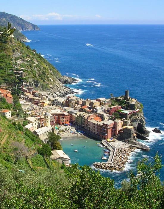
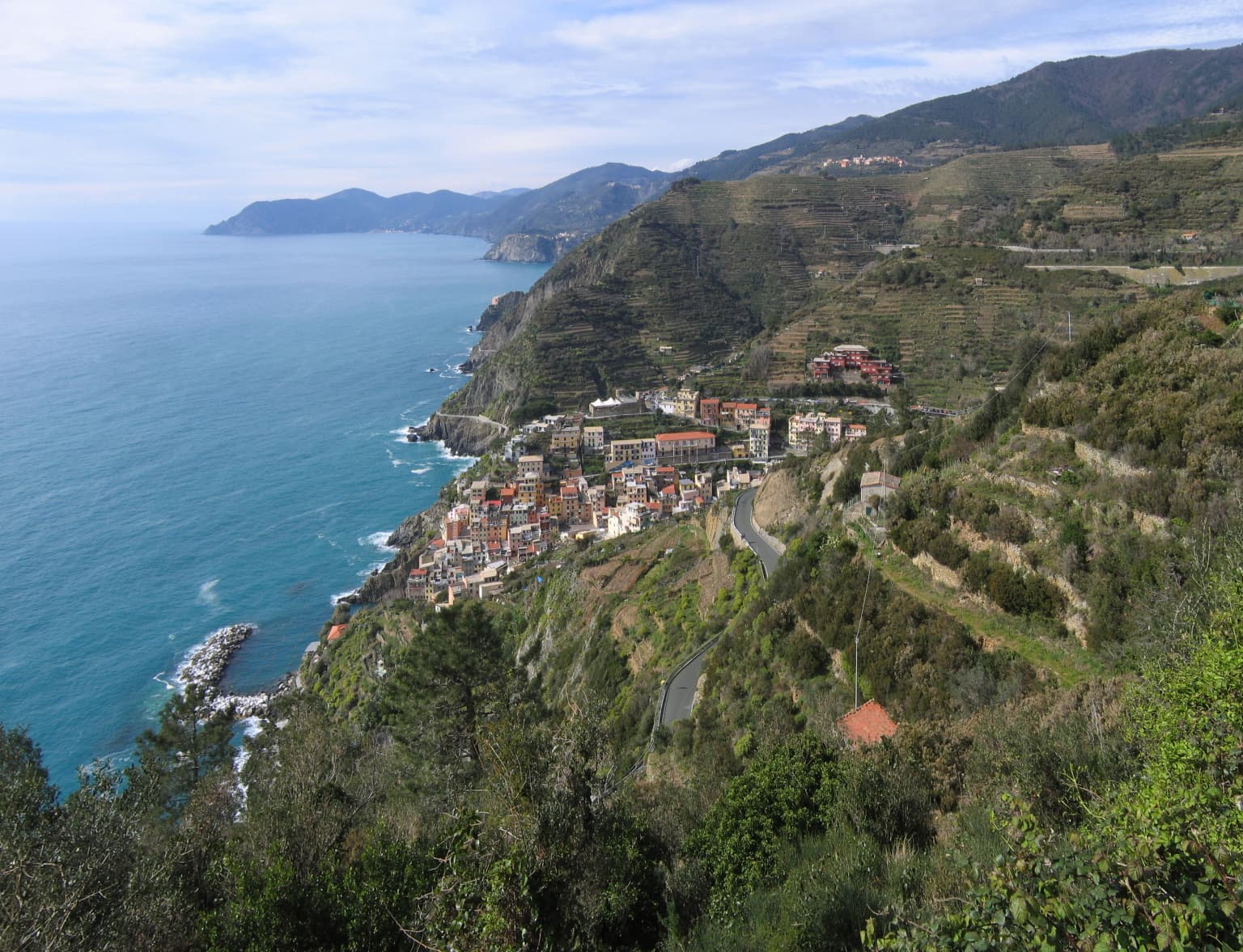
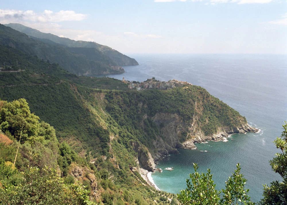
Cinque Terre is best known for its five impossibly picturesque fishing villages, whose colorful buildings appear to cling directly to the steep coastal cliffs. The area is famous for its network of historic hiking trails, particularly the Sentiero Azzurro that links all five villages along dramatic coastal paths carved into the rock face. The terraced vineyards, producing the famous Sciacchetrà wine, represent a centuries-old agricultural tradition that has transformed the hillside into a cascading landscape of stone walls and cultivated plots. The combination of natural rugged coastline, traditional architecture, and preserved rural practices makes this one of the most recognizable and photographed landscapes in the Mediterranean.

Cinque Terre National Park history and protected-area timeline

The Cinque Terre area has been inhabited since at least the medieval period, with the five villages developing as separate communities connected more by sea than by land. The construction of the coastal railway in the late 19th century brought the first modern overland access to the villages, transforming some aspects of their isolation while preserving their distinctive character. The region began attracting artistic and literary visitors in the 19th century, and its reputation as a place of unusual beauty grew steadily. The movement to protect the landscape began in earnest during the 20th century as development pressures increased and the traditional agricultural practices that maintained the terraces faced decline. Cinque Terre was inscribed as a UNESCO World Heritage Site in 1997 as part of a transboundary landscape designation recognizing its outstanding universal value. The national park was established in 1999, making it one of Italy's younger protected areas, and it was created with the specific dual mandate of preserving both the natural landscape and the traditional agricultural and fishing practices that shape the cultural environment. The park works closely with local municipalities and communities to balance conservation with the needs of residents and visitors.

Cinque Terre National Park landscape and geographic character

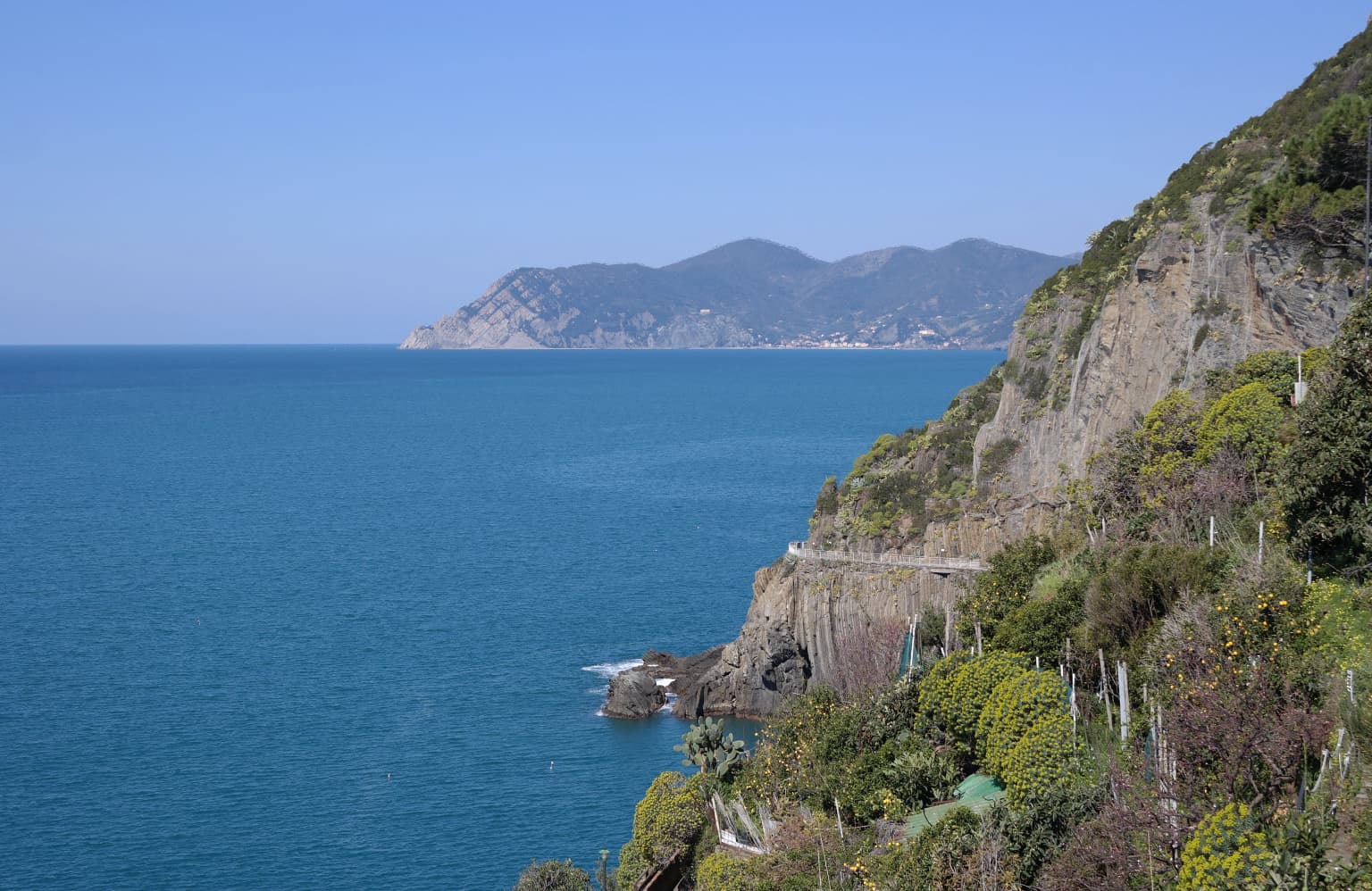
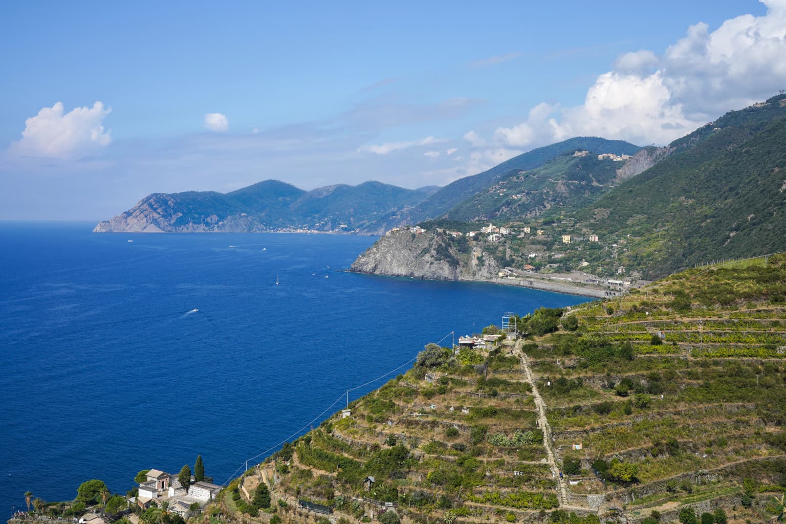
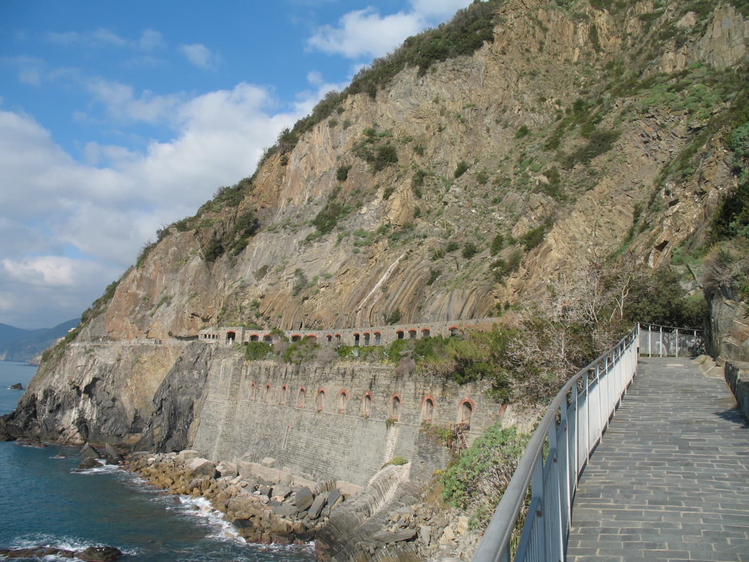
The landscape of Cinque Terre is defined by the collision between the steep-sided mountains of the Apennine foothills and the narrow coastal plain along the Ligurian Sea. Limestone cliffs rise abruptly from the water, with elevations climbing quickly from sea level to peaks exceeding 800 meters within just a few kilometers of the coast. The deep valleys that score the terrain create a succession of small bays, headlands, and ridges that give the coastline its distinctive irregular character. Between the villages, the hillsides are covered in an intricate pattern of dry-stone terracing, with walls stacked carefully to create flat platforms for cultivation. These terraces, maintained for centuries, represent an extraordinary feat of engineering and ongoing stewardship. Above the terraced zones, Mediterranean maquis covers the steeper, uncultivated slopes, while Aleppo pines and oak woodlands appear in the higher elevations. The villages themselves occupy small pocket beaches and level areas at the mouths of valleys, their colored buildings creating a sharp contrast against the darker rock and green vegetation of the surrounding hills.

Cinque Terre National Park ecosystems, habitats, and plant life

The terrestrial ecosystems of Cinque Terre reflect the Mediterranean climate and the complex terrain of the park. The lower slopes support typical Mediterranean maquis vegetation, including species such as cistus, Erica, and wild rosemary, interspersed with cultivated olive groves and vineyards. The terraced agricultural zones, though heavily modified by human activity, support a distinctive flora adapted to the specific conditions of the cultivated landscape. Higher slopes and the less-accessible areas contain Aleppo pine forests and mixed oak woodlands that represent the more natural vegetation of this part of the Ligurian coast. The marine environment within the protected area includes both rocky shores and Posidonia oceanica seagrass meadows, which are important for marine biodiversity and water quality. The park's location along the coast creates ecological corridors for migratory birds and supports populations of bird species adapted to the Mediterranean coastal environment.

Cinque Terre National Park wildlife and species highlights

The wildlife of Cinque Terre reflects the Mediterranean character of the park's coastal and hillside environments. Birdlife includes both resident species and migratory visitors, with the coastal cliffs providing nesting habitat for species such as the peregrine falcon and various seabirds. The Mediterranean maquis and woodland areas support populations of small mammals, reptiles, and insects that represent the typical fauna of this climatic zone. The marine protected area helps preserve fish populations and other marine organisms in the coastal waters, maintaining ecological connections between the terrestrial and marine environments. While Cinque Terre is not known for large mammal populations, the park's varied habitats support a decent diversity of smaller species that thrive in the Mediterranean landscape.

Cinque Terre National Park conservation status and protection priorities

Cinque Terre National Park was created with the explicit recognition that the landscape's outstanding value emerges from the interaction between natural processes and centuries of human agricultural activity. The park's conservation approach therefore focuses on maintaining both the natural ecosystems and the traditional practices, particularly terraced agriculture, that have shaped the environment over generations. The terraced vineyards and olive groves require constant maintenance, and the park works with local farmers to ensure these traditional practices continue in the face of economic pressures. The marine protected area helps safeguard the coastal waters and seabed, limiting activities that could damage the marine environment. The high visitor numbers present both a challenge and a resource for the park, as tourism revenue supports local communities while also creating pressures on the trail system and sensitive areas. Management efforts focus on sustainable visitor use, trail maintenance, and supporting the economic viability of traditional land uses.

Cinque Terre National Park cultural meaning and human context

The five villages of Cinque Terre represent a distinctive cultural tradition rooted in the particular constraints and opportunities of this rugged coastline. Fishing was historically the primary livelihood, supplemented by agriculture in the terraced fields above the villages. The villages themselves developed their characteristic dense, vertical architecture as a response to the limited flat land available along the steep coast. The distinctive colored facades of the buildings, painted in shades of ochre, pink, and terracotta, create the iconic visual character that has made the villages so widely recognized. Local cuisine reflects the maritime and agricultural traditions of the region, with anchovies, pesto alla Genovese, and the Sciacchetrà wine from the hillside vineyards representing culinary highlights. The community's connection to the land and sea has produced distinctive festivals, traditions, and social practices that continue to animate village life despite the pressures of modern tourism. The park recognizes this cultural dimension as inseparable from the natural landscape and works to support the living culture that makes Cinque Terre meaningful beyond its visual beauty.

Top sights and standout views in Cinque Terre National Park

The five villages themselves remain the heart of the Cinque Terre experience, each offering distinct characters from the larger beach resort of Monterosso to the intimate harbor of Manarola. The Sentiero Azzurro hiking trail, which winds between the villages along paths carved into the cliffs, provides the most iconic way to experience the landscape and has been described as one of the world's great walks. The terraced vineyards, particularly those above Manarola and Riomaggiore, showcase the agricultural tradition that transformed the hillsides into productive landscape. The small beaches and rocky coves along the coast offer swimming opportunities in the clear Ligurian waters. The characteristic train that connects the villages, tunneling through the hillsides, provides an alternative way to move between the five towns and allows visitors to appreciate the dramatic coastal scenery from another perspective.

Park location guide

Geography guide, regional context, and park location map for Cinque Terre National Park

Cinque Terre National Park park geography, regions, and map view in Italy
Understand where Cinque Terre National Park sits in Italy through a broader geographic reading of the surrounding landscape, nearby location context, and its mapped position within the national park landscape.

How Cinque Terre National Park fits into Italy

Italy is a unitary parliamentary republic in Southern and Western Europe, located on the Italian Peninsula with the Alps to the north. It borders France, Switzerland, Austria, Slovenia, Vatican City, and San Marino, and shares maritime boundaries with several Mediterranean countries. The country has approximately 59 million residents and uses the Euro as its currency.

Wider geography shaping Cinque Terre National Park in Italy

Italy occupies a boot-shaped peninsula in southern Europe, bordered by the Alps to the north. It shares land borders with France, Switzerland, Austria, Slovenia, Vatican City, and San Marino. The country includes the Mediterranean islands of Sicily and Sardinia, along with approximately 800 smaller islands.

Map view of Cinque Terre National Park

Use this park location map to pinpoint Cinque Terre National Park in Italy, understand its exact geographic position, and read its mapped placement within the surrounding landscape more clearly.

Pigeon | © OpenStreetMap contributors

Location context for Cinque Terre National Park

Liguria
Park atlas

Map surrounding Ligurian coastal landscapes and compare adjacent protected areas across Italy

Discover National Parks and Protected Areas Near Cinque Terre National Park, Italy
Browse additional national parks and protected areas situated geographically near Cinque Terre National Park, extending across the diverse Italian coastline and mountain regions. Explore these mapped conservation landscapes to compare their unique characteristics and understand the broader geographic context of Italy's natural heritage.
Watercolor painting of rolling green hills under a sunset sky with soft color transitions
National parkEmilia-Romagna

Appennino Tosco-Emiliano National Park: Explore Its National Park Boundaries and Geography

Discover the mapped landscape and regional context of this protected area.

Appennino Tosco-Emiliano National Park is a designated national park offering a rich area for geographic exploration. This MoriAtlas entry details the park's protected landscape, providing insights into its mapped boundaries and its contribution to the natural terrain of the Emilia-Romagna region. Understand its significance within the broader atlas of Italian protected areas, focusing on its unique geographic identity and landscape context.

Area
227.92 km²
Established
2001
IUCN
II
Relief
Mountain
National parkTuscany

Arcipelago Toscano National Park: Protected Islands and Mediterranean Landscape Atlas

Explore Tuscany's unique archipelago geography and protected natural terrain.

Arcipelago Toscano National Park offers a unique perspective on Mediterranean island ecosystems through its comprehensive atlas and mapped landscape context. Covering seven main islands and surrounding marine areas off the coast of Tuscany, this park protects dramatic granite cliffs, endemic flora, and vital habitats for marine and avian life. Understand its geographic scope, protected boundaries, and the distinctive natural terrain that defines this significant Italian conservation landscape.

Area
746.63 km²
Established
1996
IUCN
II
Relief
Mixed relief
National parkForlì-Cesena Province

Foreste Casentinesi, Monte Falterona, Campigna National Park: A Mapped Protected Landscape in Italy

National Park within Forlì-Cesena Province, Emilia-Romagna

Foreste Casentinesi, Monte Falterona, Campigna National Park is an important protected natural area situated in Forlì-Cesena Province, northeastern Italy. As a designated national park, it serves as a key landmark for exploring mapped protected land boundaries and understanding its specific contribution to the regional geography. This page provides an atlas-centric view, highlighting the park's geographic context and its identity as a significant protected landscape for discovery and reference.

Area
368 km²
Established
1993
IUCN
II
Relief
Mountain
Watercolor illustration of a mountainous landscape featuring a river, rolling hills, and green vegetation
National park

Mercantour National Park: Mapped Alpine Protected Landscape and Regional Geography

Explore France's dramatic Alps, park boundaries, and unique ecotones.

Mercantour National Park stands as a premier protected area within the French Alps, distinguished by its remarkable geographic diversity and ecological significance. This national park encompasses mountainous terrain featuring dramatic peaks, deep glacial valleys, and a unique ecotone where Mediterranean and Alpine ecosystems converge. MoriAtlas facilitates a detailed atlas-style exploration of Mercantour National Park, highlighting its mapped protected boundaries, varied natural landscapes, and its pivotal role in regional geography and conservation efforts.

Area
679 km²
Established
1979
IUCN
II
Visitors
800K annual
Watercolor illustration showing green mountains, forests, a river, and snow-capped peaks in the distance
National parkPiedmont

Val Grande National Park: National Park Protected Landscape in Piedmont

Explore its mapped boundaries and regional geographic context.

Val Grande National Park represents a key protected landscape within the Piedmont region of northwest Italy. This canonical page offers detailed insights into the park's designated status as a national park, its specific geographic placement, and its mapped protected boundaries. Users can navigate its atlas-level details to understand its role in the regional geography and conservation landscape, providing a structured foundation for further discovery of Italy's natural protected areas.

Area
170.21 km²
Established
1992
IUCN
II
Relief
Mountain
Watercolor illustration depicting green valleys, forests, and distant mountain peaks
National park

Gran Paradiso National Park: Italy's National Park Protected Landscape Atlas

Mapped boundaries and regional geography for a key Italian protected area.

Gran Paradiso National Park is a distinct national park entity within Italy, offering rich potential for atlas-driven geographic discovery. This MoriAtlas profile focuses on its protected landscape identity, providing essential context for understanding its mapped boundaries and its role within the regional geography of Italy. Explore the structured geographic details that make Gran Paradiso National Park a valuable component of any mapped landscape analysis.

Area
703 km²
Established
1922
IUCN
II
Relief
Mountain
National parkSavoie

Vanoise National Park: Explore France's Original National Park in the Savoie Alps

Mapped Alpine geography, glacial terrain, and protected landscape.

Vanoise National Park is France's pioneering national park, a protected landscape of immense alpine beauty situated in the Savoie department. Renowned for its dramatic glacial terrain, over 100 peaks above 3,000 meters, and the iconic Alpine ibex, this park offers a profound geographic context. Explore its mapped boundaries and discover the unique atlas-level insights into France's mountainous protected areas and their ecological significance.

Area
534 km²
Established
1963
IUCN
II
Relief
Mountain
National parkTrentino-Alto Adige/Südtirol

Stelvio National Park National Park: Protected Landscape and Regional Geographic Context

Explore its mapped boundaries and natural terrain.

Navigate Stelvio National Park, a designated national park in Italy's Trentino-Alto Adige/Südtirol region, through a map-centric lens. This page provides critical context for understanding the park's protected landscape, its geographic position within the Alps, and its mapped terrain. Utilize MoriAtlas to grasp the park's boundaries and its place in regional geography for structured natural landscape discovery.

Established
1935
IUCN
II
Relief
Mountain
Scope
Terrestrial

Common questions about visiting, size, designation, and location context for Cinque Terre National Park

Cinque Terre National Park FAQs for park facts, access, geography, and protected area context
Find quick answers about Cinque Terre National Park, including protected-area facts, park geography, trail and visitor context, and how the park fits into its surrounding country and regional landscape.
MoriAtlas Explorer

Continue Your Protected Areas Search Across the Global Atlas

Deepen your exploration by continuing the structured search for national parks and protected areas worldwide. Utilize the comprehensive filtering capabilities to compare different conservation landscapes and refine your understanding of global park geography. Discover more about the distribution and characteristics of protected natural areas.

Global natural geography