Mori Atlas logo
Natural monumentRoudný

Discover a unique sandy refuge for rare tiger beetles and threatened fungal species within historical mining terrain.

Roudný Natural Monument and Protected Anthropogenic Landscape in Středočeský Kraj

Roudný serves as a distinct protected area where a former gold mine spoil heap has transformed into a vital ecological refuge. This compact site in the Středočeský kraj region features sandy, disturbed terrain that supports a rare tiger beetle population, specialized orchids, and a significant diversity of fungi. It provides a specialized map-based perspective on how human-altered landscapes serve as critical habitats for rare species in the Central Bohemian countryside.

sandy habitatformer gold minespoil heapinvertebrate conservationtiger beetle habitatleaf beetle habitat

Roudný

Natural monument

Park overview

Structured park overview, official facts, and landscape profile for Roudný Natural Monument

Roudný Natural Monument park facts, protected area profile, and essential visitor context

Review the core facts for Roudný Natural Monument, including designation, size, terrain, visitor scale, habitats, and operating context in one park-focused overview.

About Roudný Natural Monument

Roudný Natural Monument centers on a single, deceptively small feature: the spoil heap of a long-abandoned gold mine near Zvěstov in the Benešov District of Central Bohemia. Although the protected footprint is modest and the topography is limited to a single mound, the locality has become a focal point for conservation biology in the region because the sandy, exposed substrate left by historical mining closely mimics the kind of open, dry sand habitat that has become increasingly rare in the modern Czech landscape.

The ecological character of the site is shaped entirely by this disturbance legacy. Gold mining removed vegetation, churned the substrate, and left behind a slope of loose sandy material that continued to evolve after the mining ceased. Over time, the heap developed into a specialized habitat mosaic: open sandy areas, partially stabilized slopes, and edges where the mining substrate meets surrounding vegetation. These conditions are unfavorable for conventional forestry or agriculture but ideal for a narrow set of species that depend on bare or sparsely vegetated sandy ground.

The monument is administered at the regional level and lies within the broader framework of the surrounding protected landscape area centered on Blaník, whose administration has an active interest in preserving the site's condition. Because Roudný is small and shaped by past human activity rather than by current management, much of its ecological value depends on maintaining open conditions and preventing further disturbance of the sandy slope.

What makes Roudný especially significant within the Czech protected-area network is that it does not protect a wilderness landscape, a forest, or a river system; it protects a localized biological phenomenon created by industry. The site's importance is measured not in hectares or dramatic scenery, but in the rarity of the species that depend on its unique substrate, and in the broader lessons it offers about conserving secondary habitats created by human history.

Quick facts and research context for Roudný Natural Monument

Roudný Natural Monument is a small protected area in the Středočeský kraj of the Czech Republic, administered at the regional level and located on the cadastral territory of Bořkovice, part of the municipality of Zvěstov in Benešov District. It was designated in 1994 under the category of přírodní památka, a designation corresponding to IUCN Category IV, focused on the protection of a particular species or habitat.

The protected site covers roughly 2.5 hectares on a former gold mining spoil heap at elevations of about 436 to 450 meters above sea level. It is a habitat shaped by human activity, and its value lies primarily in the rare sandy-substrate flora, beetle fauna, and mycological assemblages that have colonized the disturbed ground.

Protection and recognition

Documented terrestrial conservation measures and management scope

Roudný Protection Status and International Recognition Data

Roudný maintains a documented terrestrial protection scope that outlines its formal conservation boundaries and management context. Official designation records detail the administrative framework governing this protected natural terrain.

Protection details

Protection scope
Terrestrial
Transboundary protection
No
Park context

Deeper park guide and search-rich context for Roudný Natural Monument

Roudný Natural Monument history, landscape, wildlife, and travel context

Explore Roudný Natural Monument through its history, landscape character, ecosystems, wildlife, conservation priorities, cultural context, and seasonal travel timing in a structured park guide built for atlas discovery and search intent.

Why Roudný Natural Monument stands out

Roudný is best known as the only known Bohemian locality for the rare tiger beetle Cicindela arenata ssp. viennensis, a subspecies tied to open sandy terrain. The protected site is also known for its concentration of threatened leaf beetle species, including the critically endangered Cryptocephalus rufipes, and for harboring orchids and marsh plants such as lesser butterfly orchid, marsh helleborine, and grass-of-Parnassus at the edges of the heap. The former gold mine spoil heap is, in addition, recognized as a remarkable mycological locality. Surveys have documented more than 60 fungal species here, including the critically endangered Tricholoma focale, several threatened hydnoid fungi, and Sistotrema dennisii, a species newly recorded for the Czech Republic at Roudný.
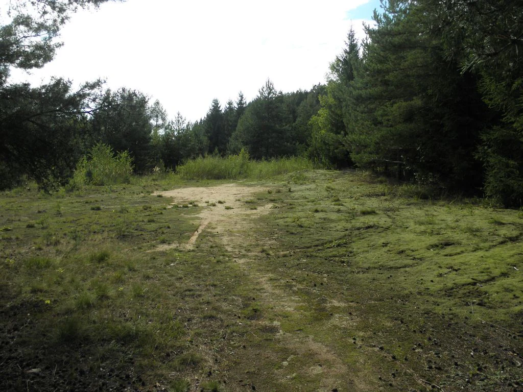
A view of an open grassy field with patches of bare sand, bordered by dense coniferous forest.
A grassy clearing with sandy soil patches within the Roudný natural monument area.

Roudný Natural Monument history and protected-area timeline

The Roudný locality is rooted in a history of gold mining whose surface legacy still defines the modern protected site. Mining activity disturbed the local substrate and left behind a slope of sandy spoil material, and it is this disturbed ground, rather than any long-standing natural ecosystem, that forms the basis of the protected area.

In 1994, Czech authorities formally designated the locality as a přírodní památka, a natural monument, recognizing the biological value the spoil heap had developed. The designation placed the site under regional administration and tied its management to the protection of the species and habitats that had colonized the former mine workings.

In the years since designation, the most prominent historical chapter has been the recurring pressure to resume mining activity. Proposals from foreign and domestic companies to carry out geological exploration for gold and silver have repeatedly reached the locality. In 2014, the Czech Ministry of the Environment rejected a request from the company Delta Bohemia s.r.o. to explore gold and silver deposits near Roudný, and the administration of the surrounding Blaník protected landscape area subsequently fined a different firm, Bioanalytika CZ, after it conducted exploratory drilling and removed material from the area in 2015. The persistent pressure from exploration interests has become, in itself, part of the locality's modern history.

Roudný Natural Monument landscape and geographic character

The landscape of Roudný is essentially the landscape of a single artificial landform: the spoil heap of the former Roudný gold mine. The mound rises between roughly 436 and 450 meters above sea level and covers a compact area of only about 2.5 hectares. Its defining physical feature is the slope of loose, sandy mining waste that spreads outward from the former workings.

Unlike conventional parks, Roudný has no broad vistas, no extensive forests, and no river corridors. The terrain is shaped by the way material was moved and deposited during historical mining: a core of disturbed ground, sandy slopes, and edges where the mining substrate transitions into surrounding vegetation. Erosion continues to slowly reshape the slope, while vegetation encroachment gradually stabilizes parts of the heap.

The broader visual context is shaped by Roudný's location in the Central Bohemian countryside near Zvěstov, where agricultural land, small villages, and forested patches surround the protected mound. Within that wider setting, the protected heap stands out as a small, distinctly open, sandy feature in an otherwise heavily vegetated Czech landscape.

Roudný Natural Monument ecosystems, habitats, and plant life

The ecological identity of Roudný is defined by the unusual habitat conditions created by the sandy spoil heap. The exposed mineral substrate, low nutrient levels, and ongoing disturbance mimic the kind of inland sandy habitats that were once more widespread in Central Europe but have become increasingly rare due to land use change. This makes the locality a refugium for plants and animals that depend on open, dry, sandy conditions.

The habitat pattern at Roudný is layered: a core area of bare and sparsely vegetated sand where pioneer species establish; slightly more stable slopes where vegetation gradually takes hold; and edges where the sandy substrate meets adjacent grasslands or shrub cover. Each zone supports a slightly different ecological community, and the overall biodiversity of the site is enhanced by the proximity of these contrasting conditions within a very small footprint.

The vegetation of the locality is unusually diverse for such a small area. At the edge of the heap, the rare orchid Platanthera bifolia has been recorded, while the sandy slopes support marsh-adapted species such as Epipactis palustris and Parnassia palustris, both strongly threatened in the Czech Republic. The mixture of dry sandy slope vegetation with wetland-affiliated plant species reflects the unusual combination of substrate and microtopography that defines the heap.

Roudný Natural Monument wildlife and species highlights

Roudný's wildlife significance is focused on a very narrow but nationally important suite of invertebrates, especially beetles associated with sandy open ground. The most distinctive species is the rare tiger beetle Cicindela arenaria ssp. viennensis, which, according to current findings, exists in Bohemia only at this one locality. The presence of this single subspecies is a primary reason the site carries formal protection.

The site also supports a notable assemblage of leaf beetles, including several threatened and critically endangered species. Recorded taxa include Smaragdina flavicollis, Cryptocephalus vittatus, and the critically endangered Cryptocephalus rufipes. The warm-adapted flea beetle Phyllotreta austriaca has also been documented here, contributing to the picture of a sandy, heat-retaining microclimate that supports a distinctive insect fauna.

Larger vertebrates are not the focus of the site's protection, and the locality's wildlife value lies overwhelmingly in its specialized invertebrate communities rather than in charismatic mammal or bird presence. The invertebrate assemblage is in many ways the core conservation argument for the monument's existence.

Roudný Natural Monument conservation status and protection priorities

From a conservation perspective, Roudný is significant because it protects a habitat type that has become rare in the modern Czech landscape: open, dry, sandy ground with sparse vegetation. The site's value is conserved not for scenery but for the rare beetles, orchids, marsh-edge plants, and fungi that depend on its specific substrate. Its designation as a přírodní památka aligns with the IUCN Category IV model of protecting a single species or habitat.

The protected area exists largely because the disturbed ground left by historical mining happens to mimic the open sandy habitats that many of these species require. The conservation challenge at Roudný is therefore partly about preserving that open character: preventing vegetation from fully overgrowing the slope, managing surface stability, and limiting erosion-driven loss of habitat on the heap.

The most visible long-term conservation pressure has come from renewed interest in gold exploration and extraction. Repeated applications by mining companies to conduct geological surveys and drilling near the protected heap have tested the regulatory framework around the site. Decisions by the Czech Ministry of the Environment and the Blaník protected landscape area administration to reject or sanction these proposals have, in practice, become important elements of Roudný's modern conservation story.

Roudný Natural Monument cultural meaning and human context

The cultural context of Roudný is closely tied to the long history of gold prospecting in the Central Bohemian countryside. The protected area is, in essence, a relic of historical mining: the landscape was reshaped by industrial-era gold digging, and the modern ecological value of the site is directly tied to the surface legacy of that activity. The locality is associated with the nearby Mořic adit and with the educational trail Naučná stezka Zlatodůl Roudný, which connects the natural monument to wider regional interest in mining heritage and natural history.

Top sights and standout views in Roudný Natural Monument

Roudný is a compact protected site whose importance far exceeds its size. Its principal highlights include the only known Bohemian population of Cicindela arenaria ssp. viennensis, a concentration of threatened leaf beetle species on the sandy slopes, and a remarkable mycological record that includes more than 60 fungal species, several of which are nationally rare or critically endangered.

Equally notable is the orchid-rich edge vegetation, where Platanthera bifolia, Epipactis palustris, and Parnassia palustris occur alongside beetle fauna typical of dry sandy habitats. The locality's highlight profile is therefore a combination of rare invertebrates, rare plants, and rare fungi, all concentrated on a single artificial landform.

Best time to visit Roudný Natural Monument

Roudný is a small biological site rather than a developed visitor landscape, so seasonal timing matters primarily for what observers hope to see. Late spring and early summer tend to bring out the activity of tiger beetles and other surface-dwelling insects on the sandy slopes, when warm, dry conditions favor the open sandy microclimate of the heap. This same period coincides with the flowering of orchids and marsh-edge plants at the edges of the spoil. Mycological interest is strongest in late summer and autumn, when fungal surveys at the site have historically documented the highest diversity, including the rare and critically endangered species that make Roudný notable among Czech myco-localities. Visitors in any season should expect a quiet, working conservation locality rather than a scenic destination.

Monthly climate preview

Examine long-term representative temperature ranges and monthly precipitation patterns for Roudný.

Roudný Climate Normals, Annual Temperature and Precipitation Rhythm

Representative coordinates record measured multi-year temperature variations and monthly precipitation distribution across the protected area. Reviewing complete twelve-month normals provides clear analytical insight into long-term meteorological trends at a representative elevation of 501 meters.
Annual mean8 °C
-3 °C19 °C
Jan-3°
Feb-2°
Mar
Apr
May12°
Jun16°
Jul19°
Aug18°
Sep13°
Oct
Nov
Dec-2°
Warmest month
July

18.6 °C

Coolest month
January

-3.1 °C

Wettest month
July

2.9 mm/day

Driest month
February

1.3 mm/day

Park location guide

Geography guide, regional context, and park location map for Roudný Natural Monument

Roudný Natural Monument park geography, regions, and map view in Czechia

Understand where Roudný Natural Monument sits in Czechia through a broader geographic reading of the surrounding landscape, nearby location context, and its mapped position within the national park landscape.

How Roudný Natural Monument fits into Czechia

Czech Republic is a landlocked Central European country with a population of approximately 10.9 million people. The nation was established as an independent state on January 1, 1993, following the dissolution of Czechoslovakia. Its capital and largest city is Prague, with other major urban centers including Brno, Ostrava, Plzeň, and Liberec.

Wider geography shaping Roudný Natural Monument in Czechia

The Czech Republic is a landlocked country in Central Europe. It is bordered by Germany to the west, Austria to the south, Poland to the northeast, and Slovakia to the southeast. The landscape is predominantly hilly, with the territory covering 78,871 square kilometers.

Map view of Roudný Natural Monument

Use this park location map to pinpoint Roudný Natural Monument in Czechia, understand its exact geographic position, and read its mapped placement within the surrounding landscape more clearly.

Pigeon | © OpenStreetMap contributors

Location context for Roudný Natural Monument

Středočeský kraj

Explore Roudný terrain, sandy habitats, and rare ecosystem photography.

Roudný Landscape and Scenery Photos: Visual Guide to the Protected Area

Visual documentation captures the unique sandy terrain and sparse slopes of Roudný. Studying these protected-area photographs reveals how historical industrial landforms support specialized regional habitats.

A view of an open grassy field with patches of bare sand, bordered by dense coniferous forest.

Park atlas

Compare nearby reserves and examine regional conservation landscapes

Explore Protected Areas and Parks Near Roudný in Central Bohemia

Visitors exploring Roudný can continue comparing nearby protected areas and regional conservation landscapes across the Central Bohemian countryside. Examining adjacent natural monuments provides broader context on local terrain and specialized habitats within the district.
Natural monumentJihočeský kraj
About 1.5 km away#1 closest

South

Vlašimská Blanice Natural Monument: Mapped River Geography and Protected Valley Terrain

A vital riverine habitat in the South Bohemian Region

Vlašimská Blanice forms a protected natural monument around an unregulated, meandering section of the Blanice River. This landscape is defined by its continuous riparian woodland, gravel-rich riverbed structures, and a surrounding mosaic of floodplains and meadows, providing essential habitat continuity within the Jihočeský kraj terrain.

Area
0.304 km²
Established
2014
IUCN
III
Relief
Upland
Watercolor painting of a peaceful wetland landscape with a pond, tall grasses, rolling hills, and a soft, muted color palette.
Natural monumentCentral Bohemia Region
About 4.2 km away#2 closest

East

Rybník Louňov Natural Monument: Mapped Geography and Protected Wetland Ecosystems

Central Bohemia Region protected wetland and pond habitat

Rybník Louňov serves as a protected natural monument defined by its intimate mosaic of open water, emergent reed beds, and wet meadow patches. Located in the Central Bohemia Region, this site provides a critical refuge for rare flora and fauna, illustrating the role of small-scale landscape preservation in maintaining regional ecological health.

Area
0.019 km²
Established
2001
IUCN
IV
Relief
Lowland
A horizontal watercolor illustration of a gentle, rolling landscape with green fields, patches of forest, and faint pink floral accents in the foreground.
Protected landscapeBenešov District
About 12 km away#3 closest

Northwest

Přírodní park Džbány-Žebrák: Geography and Protected Area Landscape Map

Mapping the forests and meadows of the Benešov District

Přírodní park Džbány-Žebrák offers a distinct look into the central Bohemian uplands, marked by gentle ridges and spring-fed valleys. This protected area supports an interconnected web of small ponds, damp woodland clearings, and rural agricultural mosaics. Use this resource to trace the park boundaries and understand the regional significance of its protected waters, orchid-rich meadows, and varied, bird-populated forests.

Area
53 km²
Established
1996
Water
Major water bodies
Natural monumentStředočeský kraj
About 16 km away#4 closest

Northeast

Na ostrově Natural Monument: Protected Juniper Habitats in Středočeský kraj, Czech Republic

Geographic landscape profile and ecological monument overview

Investigate the natural terrain and conservation value of Na ostrově, a protected site in the Benešov District. This area preserves a rare juniper-dominated hillside, offering insight into dry grassland and heath ecosystems maintained through traditional pastoral management.

Area
0.05 km²
Established
1972
IUCN
IV
Relief
Upland
Natural monumentStředočeský kraj
About 24 km away#5 closest

Northeast

Na Stříbrné Natural Monument: A Geological and Forest Sanctuary in Central Bohemia

Protected woodland and historical mining terrain

Spanning less than five hectares, Na Stříbrné represents a dense mosaic of metamorphic geology and vibrant woodland habitat. This protected area in Středočeský kraj showcases the persistence of forest flora like mezereon amidst historic industrial relics, offering a clear window into the varied terrain of the Czech landscape.

Area
0.048 km²
Established
1972
IUCN
IV
Relief
Upland
Natural monumentStředočeský kraj
About 28 km away#6 closest

West

Vápenické jezero Natural Monument: Wetland Geography and Protected Landscape in Středočeský kraj

Mapping the ecological features of the Sedlčany Basin.

Located in the Sedlčany Basin, Vápenické jezero is a protected pond system serving as a vital sanctuary for the fire-bellied toad and diverse wetland bird species. This entry provides a detailed look at its spring-fed water body, bulrush-covered surface, and long-standing ecological role in the broader landscape of central Bohemia.

Area
0.084 km²
Established
2013
IUCN
III
Relief
Upland
A watercolor painting showing a soft, panoramic landscape with rolling hills, a line of trees, and a small pond or marshy area in the foreground.
Protected landscapeStředočeský kraj
About 34 km away#7 closest

Northwest

Hornopožárský les Nature Park: Atlas of Protected Landscapes in Středočeský kraj

Granite Bedrock and Forested Terrains in Central Bohemia

Trace the undulating ridges and rocky outcrops of Hornopožárský les Nature Park, where central Bohemian geography meets historical quarrying heritage. This protected area offers a deep look into the regional forests and river valley ecosystems characteristic of the lower Posázaví landscape.

Area
25 km²
Established
2002
Relief
Upland
Climate
Temperate
Natural monumentStředočeský kraj
About 35 km away#8 closest

West

Vrškámen Natural Monument: Granite Boulder Geography and Regional Protected Area Map

Geological preservation in the Středočeský kraj region

Vrškámen is a significant natural monument defined by its massive porphyritic syenite boulder. This compact protected site highlights the erosion history of the Central Bohemian Pluton. It functions as an essential reference for geologists interested in the residual rock forms of the Vlašimská pahorkatina hill country and the broader Sedlčansko geological landscape.

Established
1977
IUCN
III
Relief
Upland
Climate
Temperate

Common questions about visiting, size, designation, and location context for Roudný Natural Monument

Roudný Natural Monument FAQs for park facts, access, geography, and protected area context

Find quick answers about Roudný Natural Monument, including protected-area facts, park geography, trail and visitor context, and how the park fits into its surrounding country and regional landscape.
MoriAtlas Explorer

Continue Your Protected Areas Search Across the Global Atlas

Deepen your exploration by continuing the structured search for national parks and protected areas worldwide. Utilize the comprehensive filtering capabilities to compare different conservation landscapes and refine your understanding of global park geography. Discover more about the distribution and characteristics of protected natural areas.

Global natural geography