
Mori Atlas logo
Natural monumentVápenické jezero

Understanding the mapped pond topography, reedbed habitats, and ecological significance of this Central Bohemian site.

Vápenické jezero Natural Monument: A Wetland Protected Landscape in Středočeský kraj

(Přírodní památka Vápenické jezero)

Vápenické jezero represents a significant natural monument and wetland habitat within the rolling terrain of the Benešov Hills in the Czech Republic. This protected area features a spring-fed pond with a sandy bottom and dense bulrush stands that serve as critical nesting and foraging grounds. By analyzing its mapped boundaries and regional context, one can observe how this site functions as an integrated node within the Natura 2000 network for the protection of amphibians.

wetlandpondnatural monumentamphibian habitatfire-bellied toadbulrush beds
A flat-style digital illustration showing a lush wetland foreground with reeds, a winding stream, a distant waterfall cascading down rocky canyon walls, and a soft sun in the sky.

Vápenické jezero

Natural monument

Park overview

Structured park overview, official facts, and landscape profile for Vápenické jezero

Vápenické jezero park facts, protected area profile, and essential visitor context

Review the core facts for Vápenické jezero, including designation, size, terrain, visitor scale, habitats, and operating context in one park-focused overview.

About Vápenické jezero

Vápenické jezero is a small but ecologically significant protected natural area in the Central Bohemian Region of the Czech Republic, located a short distance east of the village of Vysoký Chlumec. Although its overall extent is modest, the reserve captures an unusual concentration of wetland biodiversity, including a regionally important population of amphibians and several protected plant and bird species.

The site lies in the Sedlčany Basin, a broad depression within the Benešov Hills, a geomorphological region of rolling countryside south of Prague. This setting gives the area a relatively gentle terrain, with the protected pond occupying a natural low point where groundwater emerges. The result is a spring-fed water body with a sandy bottom, fringed and partially overgrown by bulrush and other wetland vegetation.

Beyond the central pond, the reserve is closely connected to a wider historical landscape of artificial ponds, the so-called Vápenice Lakes. These ponds, traditionally attributed to the 16th-century fishpond builder Jakub Krčín of Jelčany and Sedlčany, illustrate how centuries-old human landscape engineering continues to define the hydrological and ecological character of the area.

Vápenické jezero is also embedded in the wider European conservation framework. The protected area coincides with a European Site of Community Importance, reflecting its value for habitats and species of EU-level concern. Its primary conservation target is the fire-bellied toad, but the supporting habitat conditions also benefit a wider suite of wetland-dependent plants, reptiles, and birds.

As a whole, the reserve functions both as a refuge for rare species and as an example of the kind of small-scale, biodiversity-rich freshwater sites that characterise the Central Bohemian countryside. Its combination of natural groundwater influence, historical pond infrastructure, and dense emergent vegetation gives the site a layered ecological identity that goes beyond any single species or habitat.

Quick facts and research context for Vápenické jezero

Vápenické jezero is a Czech natural monument (přírodní památka), declared on 30 August 2013 by the Regional Authority of the Central Bohemian Region and administered by it. The protected area covers about 8.36 hectares in the Příbram district of central Bohemia, at an elevation of roughly 404 to 407 meters above sea level.

The core of the reserve is a pond of approximately 2.5 hectares with a sandy bottom, fed mainly by springs and partly by a local surface stream. It lies in a depression of the Sedlčany Basin, within the larger Benešov Hills geomorphological unit, together with a broader system of ponds historically known as the Vápenice Lakes.

The designation as a European Site of Community Importance reflects the site's role in conserving threatened wetland-dependent species, especially amphibians such as the fire-bellied toad.

Protection and recognition

Documented terrestrial protection scope and official Natura 2000 records

Vápenické Jezero Protection Status and International Recognition Data

Vápenické jezero holds documented terrestrial protection status supported by official Natura 2000 recognition records. Structured conservation metadata details the established administrative boundary parameters for this protected area.

International recognition

Protection details

Protection scope
Terrestrial
Transboundary protection
No
Park context

Deeper park guide and search-rich context for Vápenické jezero

Vápenické jezero history, landscape, wildlife, and travel context

Explore Vápenické jezero through its history, landscape character, ecosystems, wildlife, conservation priorities, cultural context, and seasonal travel timing in a structured park guide built for atlas discovery and search intent.

Why Vápenické jezero stands out

Vápenické jezero is best known as one of the key Czech sites for the fire-bellied toad, a strongly endangered species whose presence triggered the area's formal protection. The site is also notable for its combination of spring-fed pond habitat and large bulrush stands, which together support a distinctive wetland community. On a broader level, the reserve stands out as a representative example of the smaller, ecologically rich lowland pond systems of central Bohemia. Its overlap with a European Site of Community Importance highlights its role within the EU Natura 2000 network, particularly for the conservation of amphibians and associated wetland habitats.
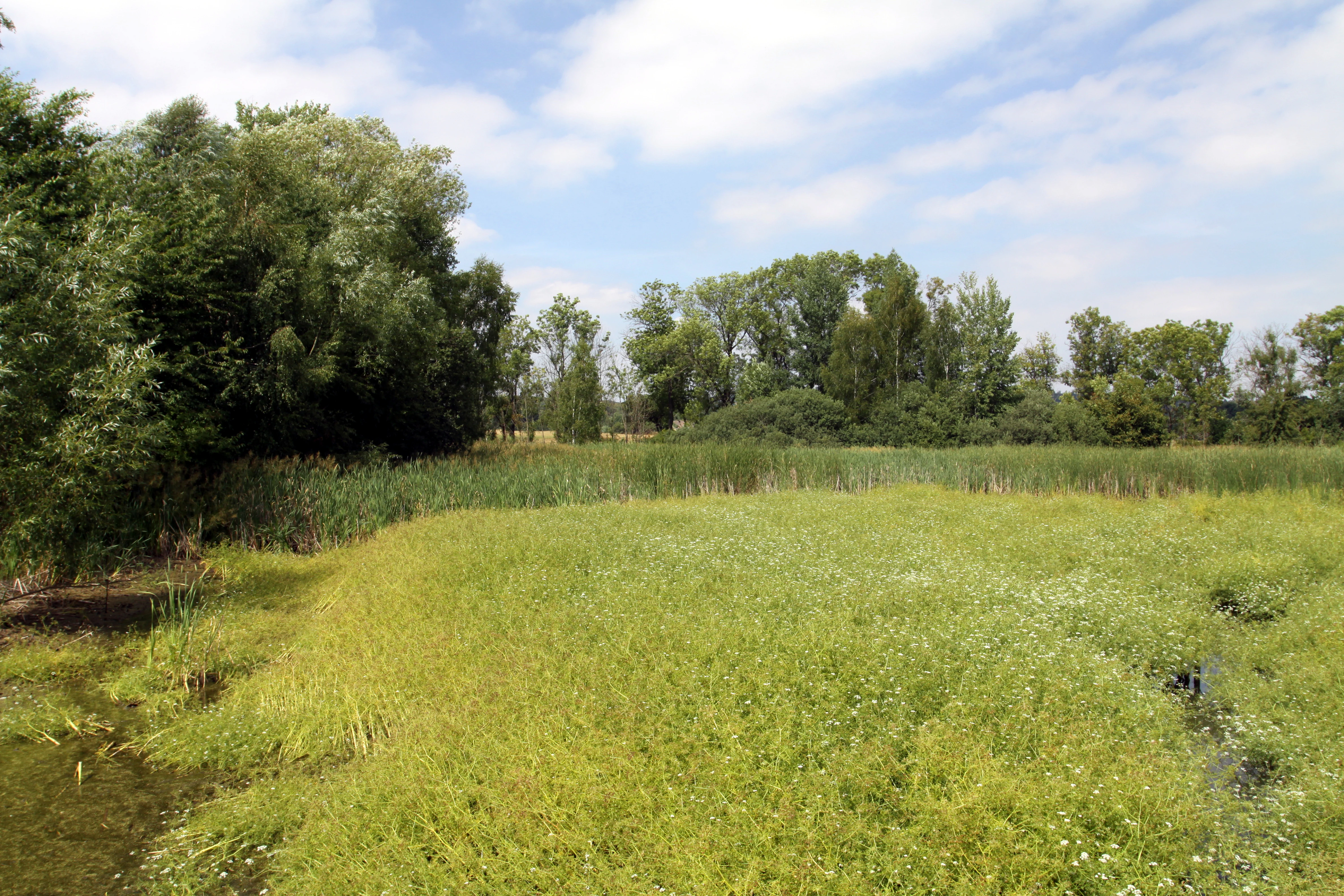
A wetland landscape featuring a lush green grassy area in the foreground and a dense line of trees in the background under a blue sky with light clouds.
A summer view of the wetland habitat at the Vápenické jezero natural monument.

Vápenické jezero history and protected-area timeline

Vápenické jezero was formally declared a Czech natural monument (přírodní památka) on 30 August 2013 by the Regional Authority of the Central Bohemian Region, which remains the administrative body responsible for the site. The designation was prompted by the area's ecological value, particularly its importance for endangered wetland species.

Although the formal protection of the site is recent, the pond itself is part of a much older cultural landscape. The wider cluster of ponds around the village of Vápenice, often referred to as the Vápenice Lakes, is traditionally believed to have been established in the 16th century by the celebrated Bohemian fishpond builder Jakub Krčín of Jelčany and Sedlčany, who shaped many of the most important artificial water bodies of southern and central Bohemia.

Over time, what began as a man-made hydrological feature evolved into a biologically rich wetland. The gradual spread of bulrush beds and the accumulation of protected flora and fauna eventually gave the site the ecological profile that justified its inclusion in the Natura 2000 network as a European Site of Community Importance, and ultimately its designation as a national natural monument in 2013.

Vápenické jezero landscape and geographic character

Vápenické jezero lies in the Sedlčany Basin, a broader structural depression within the Benešov Hills geomorphological region of central Bohemia. The surrounding terrain is gently rolling, typical of this part of the Czech landscape south of Prague, with elevations in the reserve itself ranging between roughly 404 and 407 meters above sea level.

The defining landscape feature of the site is the central pond, which occupies the lowest part of the local topography. The pond has a sandy bottom and measures about 2.5 hectares, with water input dominated by groundwater springs and supplemented by a small local surface stream. Outflow from the pond feeds the neighbouring Olešný pond, linking Vápenické jezero into an active network of small water bodies.

Vegetation strongly shapes the visual character of the site. Approximately two thirds of the pond's surface is covered by dense stands of bulrush, creating a patchwork of open water, reedbeds, and wet margins. Away from the water, the broader landscape retains the character of the Central Bohemian countryside, with mixed land use around the historic village of Vápenice.

Vápenické jezero ecosystems, habitats, and plant life

The natural character of Vápenické jezero is defined by its spring-fed pond ecosystem and the dense emergent vegetation that has developed around it. The combination of stable groundwater input, sandy substrate, and extensive bulrush stands creates habitat conditions that support both submerged aquatic plants and the animal communities dependent on shallow, vegetated freshwater.

The site's flora is remarkable for including the critically endangered common bladderwort (Utricularia vulgaris), which grows here relatively abundantly along with tussock sedge (Carex cespitosa) and bogbean (Menyanthes trifoliata). These species are typical indicators of nutrient-poor, spring-influenced wetland conditions, and their presence reflects the relatively undisturbed hydrological character of the site.

Ecologically, the reserve functions as a stepping stone in the wider Central Bohemian freshwater network. The shore zones, open water patches, and reedbeds each host different groups of organisms, giving the small site a layered habitat structure. This mosaic of microhabitats is what makes it valuable not only for a single flagship species, but for a broader wetland community.

Vápenické jezero wildlife and species highlights

The wildlife significance of Vápenické jezero centres on its amphibian population, particularly the fire-bellied toad, a strongly endangered species in the Czech Republic and the principal reason for the site's conservation designation. Several other amphibian species also occur in and around the pond, contributing to a rich frog and toad community supported by the shallow, well-vegetated water.

Reptile presence is also documented. The sand lizard (Lacerta agilis), grass snake (Natrix natrix), and slow worm (Anguis fragilis) have all been recorded at the locality, taking advantage of the warm, open margins around the water body. Such reptile records reinforce the site's value as a mosaic habitat combining wet and dry microconditions.

The reedbeds and open water attract a characteristic assemblage of wetland birds. Among the species observed are the great reed warbler (Acrocephalus arundinaceus), Savi's warbler (Locustella luscinioides), common kingfisher (Alcedo atthis), marsh harrier (Circus aeruginosus), great crested grebe (Podiceps cristatus), and grey heron (Ardea cinerea). Signs of the Eurasian otter (Lutra lutra) have also been documented, indicating the functioning of the broader pond network as a corridor for larger wetland mammals.

Vápenické jezero conservation status and protection priorities

From a conservation perspective, Vápenické jezero is significant because it combines national-level nature protection with European-level recognition. The site is simultaneously a Czech natural monument, declared in 2013, and part of a European Site of Community Importance under the Natura 2000 network, both bearing the name Vápenické jezero. This dual designation reflects the site's transboundary ecological importance.

The core conservation goal is the protection and continued presence of the fire-bellied toad, a strongly endangered amphibian species. Protecting the surrounding pond habitats, springs, and bulrush stands is essential to maintaining viable breeding conditions, not only for the toad itself but for the wider wetland community.

Beyond the flagship amphibian, the reserve conserves a network of rare or threatened plants, reptiles, and birds whose long-term survival depends on the integrity of the spring-fed hydrology and the relatively undisturbed shoreline vegetation. Maintaining the natural water regime and limiting habitat disturbance remain the central management priorities for this small but ecologically dense site.

Vápenické jezero cultural meaning and human context

The cultural context of Vápenické jezero is closely tied to the long tradition of fishpond construction in southern and central Bohemia. The pond is part of a wider system of historic water bodies around the village of Vápenice, often referred to as the Vápenice Lakes, which are traditionally attributed to the work of Jakub Krčín of Jelčany and Sedlčany, a prominent 16th-century fishpond engineer whose influence shaped much of the region's water landscape.

This historical pond-building heritage gives the site a dual identity: it is simultaneously a cultural artefact of medieval and early modern landscape management, and a modern-natural wetland of recognized ecological importance. The surrounding villages, including Vápenice and the nearby Vysoký Chlumec, form the rural Central Bohemian setting within which the protected area is embedded.

Top sights and standout views in Vápenické jezero

Vápenické jezero offers a compact but unusually rich combination of natural features: a spring-fed pond with a sandy bottom, extensive bulrush growth covering roughly two thirds of its surface, and a protected status at both national and European levels. Its most distinctive attribute is the presence of the fire-bellied toad, supported by a broader community of amphibians, reptiles, and wetland birds.

The site is also notable for its layered identity. It is both a heritage of 16th-century Bohemian pond-building and a contemporary Natura 2000 site, illustrating how centuries-old human-made water features can evolve into ecologically valuable natural habitats. The result is a small reserve with an unusually strong concentration of conservation, ecological, and cultural significance.

Best time to visit Vápenické jezero

Vápenické jezero is fundamentally a wetland and amphibian-focused site, so the richest experience of its ecological character comes in the warmer half of the year. Late spring and early summer, when amphibians are active in and around the pond and bulrush stands are fully developed, offer the most vivid sense of its wetland biodiversity.

Bird activity is also highest from late spring through summer, when reedbed-nesting warblers, marsh harriers, kingfishers, and grebes are present. Outside of this period, the open water and surrounding countryside of the Benešov Hills still retain their gentle, rural character, though much of the site's wildlife interest is reduced in the colder months.

Monthly climate preview

Long-term representative coordinate measurements for monthly temperature and precipitation rhythms

Vápenické jezero Climate Normals, Annual Temperature and Precipitation Patterns

Historical climate data for Vápenické jezero tracks measured average monthly temperatures alongside recorded daily precipitation values from 1991 to 2020. Detailed month-by-month records provide complete context for the regional temperature range and precipitation totals.
Annual mean8 °C
-3 °C19 °C
Jan-3°
Feb-1°
Mar
Apr
May13°
Jun17°
Jul19°
Aug19°
Sep14°
Oct
Nov
Dec-2°
Warmest month
July

18.9 °C

Coolest month
January

-2.7 °C

Wettest month
June

2.8 mm/day

Driest month
February

1.2 mm/day

Park location guide

Geography guide, regional context, and park location map for Vápenické jezero

Vápenické jezero park geography, regions, and map view in Czechia

Understand where Vápenické jezero sits in Czechia through a broader geographic reading of the surrounding landscape, nearby location context, and its mapped position within the national park landscape.

How Vápenické jezero fits into Czechia

Czech Republic is a landlocked Central European country with a population of approximately 10.9 million people. The nation was established as an independent state on January 1, 1993, following the dissolution of Czechoslovakia. Its capital and largest city is Prague, with other major urban centers including Brno, Ostrava, Plzeň, and Liberec.

Wider geography shaping Vápenické jezero in Czechia

The Czech Republic is a landlocked country in Central Europe. It is bordered by Germany to the west, Austria to the south, Poland to the northeast, and Slovakia to the southeast. The landscape is predominantly hilly, with the territory covering 78,871 square kilometers.

Map view of Vápenické jezero

Use this park location map to pinpoint Vápenické jezero in Czechia, understand its exact geographic position, and read its mapped placement within the surrounding landscape more clearly.

Pigeon | © OpenStreetMap contributors

Location context for Vápenické jezero

Středočeský kraj
Recorded earthquake history

Review Historical Seismic Activity Associated with Vápenické jezero

Examine the complete, filterable record of historical earthquakes associated with the Vápenické jezero natural monument. MoriAtlas presents this seismic data to help users understand the history of regional ground motion and epicentre distribution without providing predictive hazard assessments.

Vápenické jezero Earthquake History

Catalogued events

2 events

Strongest magnitude

Magnitude 3.5

Most recent event

Jun 15, 2000

This history includes earthquakes recorded inside the park or within 50 km of its borders

Explore detailed park photos, spring-fed pond terrain, and bulrush ecosystems.

Vápenické jezero Landscape and Scenery: Visualizing Central Bohemian Wetland Habitats

Visual records reveal the spring-fed waters, sandy bottom features, and extensive bulrush stands that define the protected landscape of Vápenické jezero. Examining these detailed habitat photographs helps researchers understand the environmental character and wetland ecology of this Central Bohemian natural monument.

A wetland landscape featuring a lush green grassy area in the foreground and a dense line of trees in the background under a blue sky with light clouds.

Park atlas

Compare nearby wetland reserves and regional conservation areas across central Bohemia

Other Parks Near Vápenické Jezero and Surrounding Protected Landscapes

Browse protected areas and regional wetland reserves situated close to Vápenické jezero. Expanding the geographical search reveals connected aquatic ecosystems and similar lowland habitats across the surrounding terrain.
Natural monumentStředočeský kraj
About 8.8 km away#1 closest

Southwest

Vrškámen Natural Monument: Granite Boulder Geography and Regional Protected Area Map

Geological preservation in the Středočeský kraj region

Vrškámen is a significant natural monument defined by its massive porphyritic syenite boulder. This compact protected site highlights the erosion history of the Central Bohemian Pluton. It functions as an essential reference for geologists interested in the residual rock forms of the Vlašimská pahorkatina hill country and the broader Sedlčansko geological landscape.

Established
1977
IUCN
III
Relief
Upland
Climate
Temperate
A horizontal watercolor illustration of a gentle, rolling landscape with green fields, patches of forest, and faint pink floral accents in the foreground.
Protected landscapeBenešov District
About 19 km away#2 closest

East

Přírodní park Džbány-Žebrák: Geography and Protected Area Landscape Map

Mapping the forests and meadows of the Benešov District

Přírodní park Džbány-Žebrák offers a distinct look into the central Bohemian uplands, marked by gentle ridges and spring-fed valleys. This protected area supports an interconnected web of small ponds, damp woodland clearings, and rural agricultural mosaics. Use this resource to trace the park boundaries and understand the regional significance of its protected waters, orchid-rich meadows, and varied, bird-populated forests.

Area
53 km²
Established
1996
Water
Major water bodies
A horizontal watercolor painting depicting a soft green landscape with scattered trees, rolling hills, and a pale pink sky on a white background.
Natural monumentJihočeský kraj
About 22 km away#3 closest

Southwest

Sobědražský Prales Natural Monument: Protected Woodland Map and Geographic Context

An ancient oak and beech forest remnant in the South Bohemian Region.

Sobědražský prales represents a significant natural monument within the Czech Republic, protecting a rare stand of aged oaks and beeches. This site offers valuable insights into the historical composition of local forests, supporting critical biodiversity such as hole-nesting birds amidst the managed landscapes of the Jihočeský kraj.

Area
0.017 km²
Established
1986
IUCN
IV
Relief
Upland
A watercolor painting of a river landscape with rolling hills in the background and soft vegetation along the banks.
Natural monumentJihočeský kraj
About 22 km away#4 closest

South

Smutný Natural Monument: Geographic Profile and Protected Fluvial Landscape in Jihočeský Kraj

A naturally meandering lowland stream corridor in the Czech Republic

The Smutný Natural Monument protects a significant 2.5 kilometer reach of the Smutná River, characterized by its remarkably intact fluvial morphology. Unlike typical agricultural watercourses in the region, this corridor features natural riffle-pool sequences and sediment deposition patterns along a gentle Bohemian valley. The protected site serves as a vital ecological anchor for riparian vegetation and wetland flora, demonstrating how undisturbed stream dynamics shape local terrain and provide persistent freshwater habitats.

Area
0.044 km²
Established
1985
IUCN
III
Relief
Lowland
A minimalist watercolor illustration depicting a soft, light-toned landscape with a row of trees on the right and distant, blurred hills in the background.
Natural monumentJihočeský kraj
About 24 km away#5 closest

South

Rukávečská obora: Natural Monument and Protected Beech Forest in Jihočeský kraj

A historic protected landscape in the Písek Highlands

Located in the Czech Republic, Rukávečská obora represents a significant natural monument defined by its 225-year-old beech stands. This site provides an essential look at the geological and botanical history of the Písek Highlands, serving as a key protected area for local invertebrate and bird species within the Vltava river valley watershed.

Area
0.067 km²
Established
1929
IUCN
V
Relief
Upland
Natural monumentStředočeský kraj
About 28 km away#6 closest

East

Roudný Natural Monument: Mapping Protected Mining Habitats in Středočeský Kraj

Explore the geography of this rare sandy sanctuary for invertebrates and fungi.

Roudný is a specialized natural monument protecting the sandy, nutrient-poor substrate of a former gold mine. The site stands as a significant biological island in Středočeský kraj, supporting species dependent on open, eroded sandy slopes that are now rare in the wider regional landscape. Its compact geography highlights the intersection of industrial history and conservation in the Czech Republic.

Area
0.025 km²
Established
1994
IUCN
IV
Relief
Lowland
Natural monumentJihočeský kraj
29 km away#7 closest

East

Vlašimská Blanice Natural Monument: Mapped River Geography and Protected Valley Terrain

A vital riverine habitat in the South Bohemian Region

Vlašimská Blanice forms a protected natural monument around an unregulated, meandering section of the Blanice River. This landscape is defined by its continuous riparian woodland, gravel-rich riverbed structures, and a surrounding mosaic of floodplains and meadows, providing essential habitat continuity within the Jihočeský kraj terrain.

Area
0.304 km²
Established
2014
IUCN
III
Relief
Upland
Nature reserveStředočeský kraj
About 30 km away#8 closest

North

Vlčí rokle Nature Reserve: Geological Ravines and Ancient Beech Forests in Středočeský kraj

Mapping protected natural monument boundaries and ancient woodland remnants

Explore the geological and botanical features of Vlčí rokle, an exceptional nature reserve set within the Středočeský kraj. This protected area safeguards a fragment of ancient beech forest and a granite-boulder-strewn ravine, representing a classic example of central Bohemian geological and ecological heritage.

Area
0.085 km²
Established
1990
IUCN
III
Relief
Upland

Common questions about visiting, size, designation, and location context for Vápenické jezero

Vápenické jezero FAQs for park facts, access, geography, and protected area context

Find quick answers about Vápenické jezero, including protected-area facts, park geography, trail and visitor context, and how the park fits into its surrounding country and regional landscape.
MoriAtlas Explorer

Continue Your Protected Areas Search Across the Global Atlas

Deepen your exploration by continuing the structured search for national parks and protected areas worldwide. Utilize the comprehensive filtering capabilities to compare different conservation landscapes and refine your understanding of global park geography. Discover more about the distribution and characteristics of protected natural areas.

Global natural geography