
Mori Atlas logo
Natural monumentRudmose Aggerø

Explore the unique coastal terrain, shallow marine habitats, and protected sandbank ecosystems

Rudmose Aggerø Natural Monument and Protected Fjord Landscape in Northern Denmark

Rudmose Aggerø sits as a quiet, low-lying island within the shallow waters of the western Limfjorden. This natural monument is defined by its integration into a vital Natura 2000 network that safeguards complex intertidal flats, sandbanks, and diverse avian habitats. The landscape is characterized by its gentle, horizontal coastal vistas where rural island geography meets the still waters and protected reefs of northern Denmark.

fjord islandLimfjordenshallow marine habitatsandbanksintertidal flatsbird protection area
A stylized illustration showing a waterfall cascading from a cliff into a body of water, with a foreground of a pebble beach and yellow and white flowers.

Rudmose Aggerø

Natural monument

Park overview

Structured park overview, official facts, and landscape profile for Rudmose Aggerø

Rudmose Aggerø park facts, protected area profile, and essential visitor context

Review the core facts for Rudmose Aggerø, including designation, size, terrain, visitor scale, habitats, and operating context in one park-focused overview.

About Rudmose Aggerø

Rudmose Aggerø is a small, flat Danish island in the Limfjorden, the broad, shallow sound that cuts across northern Jutland. Positioned between the island of Mors to the north and the Thyholm peninsula to the south, it covers only a few square kilometers of land and is bordered almost entirely by calm, sheltered fjord waters. A causeway links the island to Mors, anchoring its modern everyday life to the larger landmass while preserving its distinct island identity.

The character of Rudmose Aggerø is shaped by its relationship with the surrounding fjord. Rather than dramatic cliffs or forested hills, the island presents the typical low-relief coastal scenery of the western Limfjorden: gentle shorelines, shallow tidal flats, sandy banks, and views across open water to neighboring land. A scattering of small uninhabited islands and reefs lies offshore, creating the kind of quiet, varied inshore environment that distinguishes this part of Denmark from the more exposed North Sea coast further west.

Although the island itself is small and largely rural, its ecological setting is nationally and Europeanly significant. The marine and intertidal areas around Rudmose Aggerø are part of a designated Natura 2000 site that protects both habitat types and bird populations, and a dedicated nature reserve on the island is managed by the Danish Ornithological Protection Fund. Together with neighboring Mors and the broader Limfjorden system, Rudmose Aggerø forms a piece of a much larger protected fjord landscape in northern Denmark.

Quick facts and research context for Rudmose Aggerø

Rudmose Aggerø lies in the Limfjorden in the Central Denmark Region, administratively part of Morsø Kommune. It is one of the many small Danish fjord islands, separated from Mors to the north by a short stretch of water crossed by a causeway, and from Thyholm to the south by a wider section of the fjord.

The island is small and largely rural, with a long-standing but very limited permanent population. The coastal and marine environment around the island carries formal European protection status through Natura 2000, and the island itself hosts a privately owned nature reserve managed by a national bird conservation organization. These factors together give Rudmose Aggerø an ecological profile that is disproportionately significant relative to its modest size.

Protection and recognition

Examine official designation history, management scope, and recognition data.

Rudmose Aggerø Protection Status and Documented Conservation Scope

Rudmose Aggerø maintains a documented mixed protection status within regional conservation inventories and administrative frameworks. Review verified designation records, management scope details, and international recognition facts compiled for this protected area.

Protection details

Protection scope
Mixed
Transboundary protection
No
Core area
0.28 km²
Park context

Deeper park guide and search-rich context for Rudmose Aggerø

Rudmose Aggerø history, landscape, wildlife, and travel context

Explore Rudmose Aggerø through its history, landscape character, ecosystems, wildlife, conservation priorities, cultural context, and seasonal travel timing in a structured park guide built for atlas discovery and search intent.

Why Rudmose Aggerø stands out

Rudmose Aggerø is best known for its integration into the protected shallow-water ecosystem of the western Limfjorden, an area recognized under Natura 2000 for both its habitat value and its importance for waterbirds. The island sits within a mosaic of sandbanks, sand flats, and small offshore islets that characterize this part of the fjord. The presence of a nature reserve on the northwestern part of the island, held by the Danish Ornithological Protection Fund, reinforces Rudmose Aggerø's reputation as a quiet but meaningful refuge for coastal birdlife within an otherwise inhabited, working agricultural landscape.
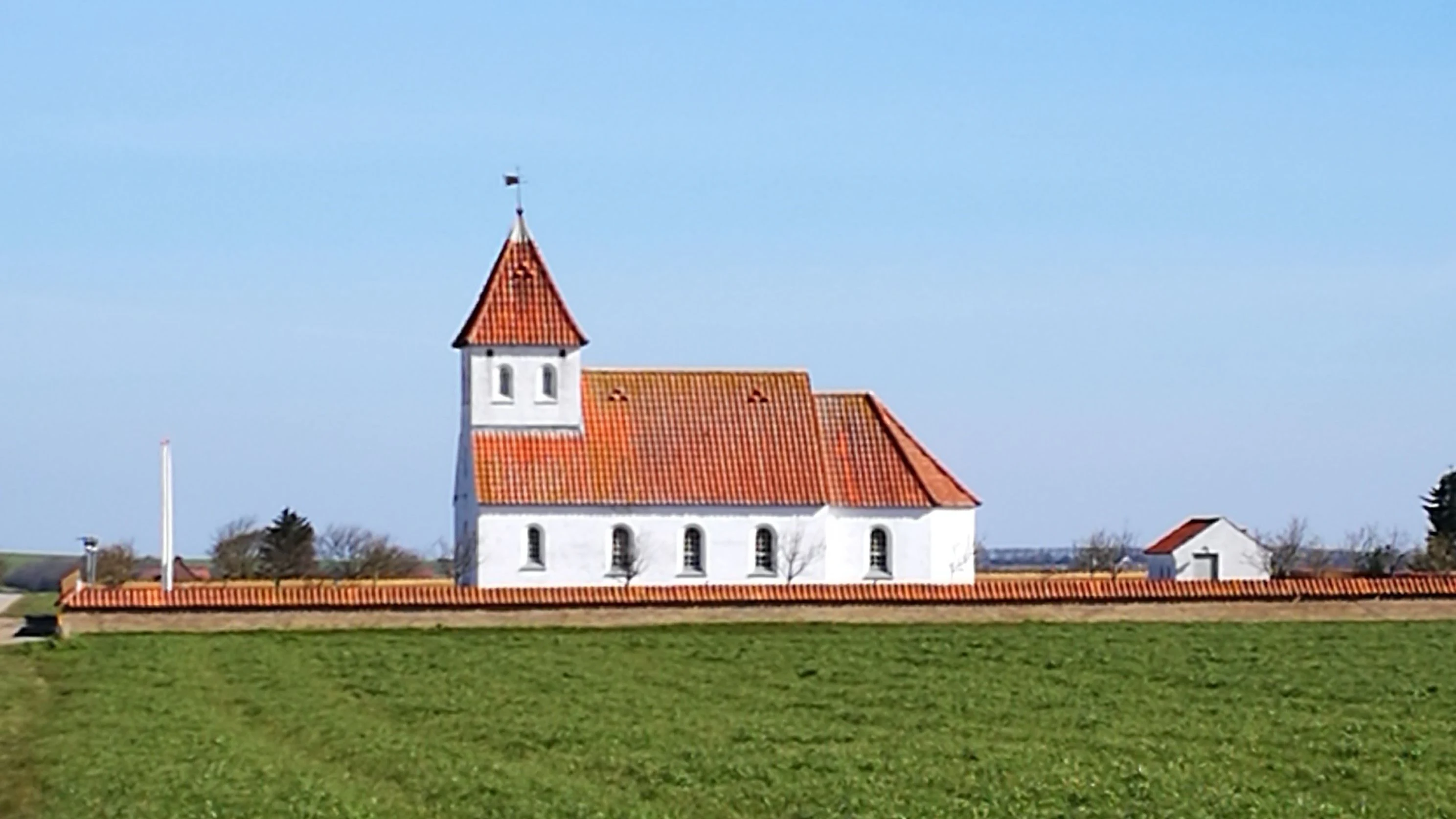
A white church with a red tiled roof and a small tower, surrounded by a low brick wall, standing in a green field under a clear blue sky.
Agerø Church, a white building with a red tiled roof, situated in a green field in North Jutland, Denmark.

Rudmose Aggerø landscape and geographic character

The landscape of Rudmose Aggerø is defined by its position in the western Limfjorden, one of the calmest and shallowest marine areas in Denmark. The island is essentially flat, with no dramatic relief, and its coastline is shaped by gentle inlets, shallow bays, and stretches of beach facing broad expanses of still water. From shore-level vantage points the eye is drawn west across the fjord, where the water meets a low horizon of more islands, sand, and the distant outline of Thyholm.

Surrounding the island, sandbanks, reefs, and small uninhabited islets create an almost archipelago-like texture in the fjord. These shallow offshore features mean that the waters close to Rudmose Aggerø are often barely submerged, producing the sand-flat and sand-wad environments typical of the western Limfjorden. The result is a soft, layered seascape rather than a rugged one, defined more by horizontals, light on water, and shifting tidal patterns than by any vertical relief.
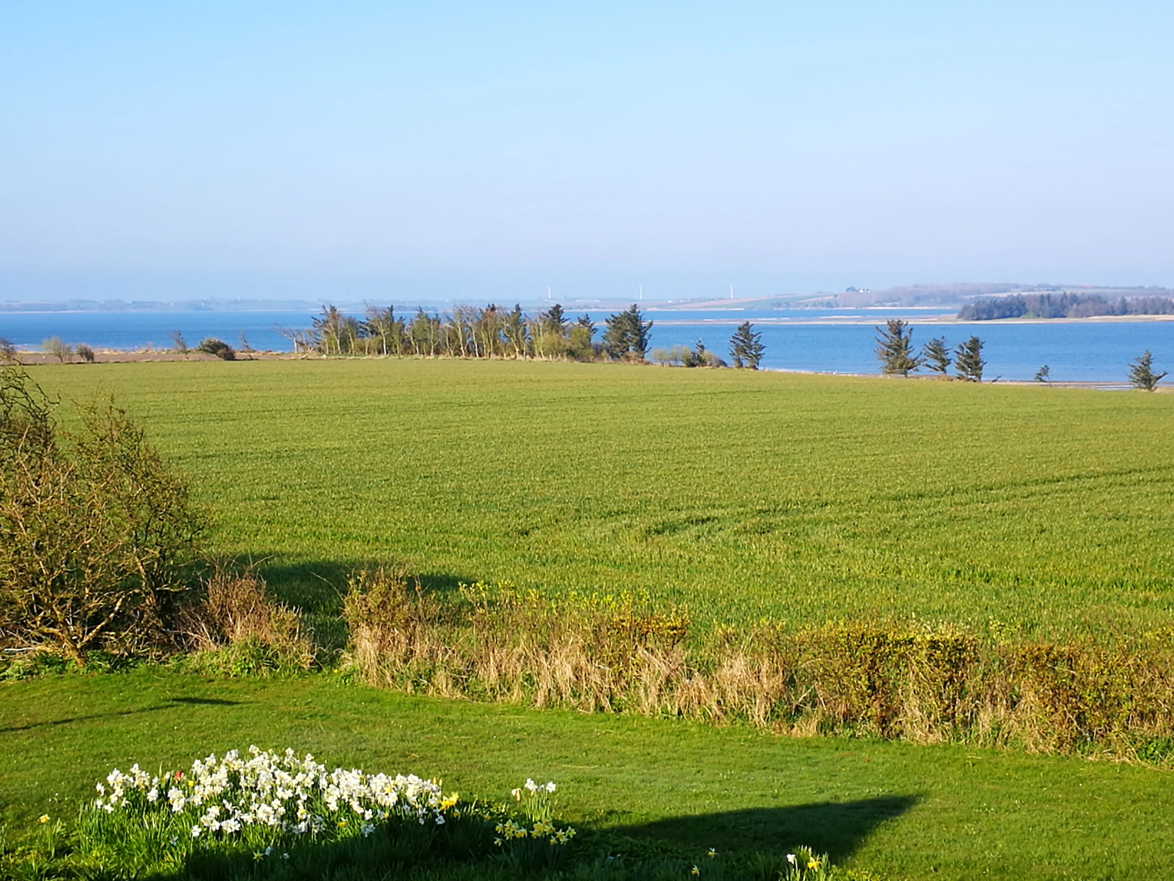
A wide landscape view showing a large green agricultural field in the foreground and midground, bordered by a hedge and white flowers, leading to a blue body of water and distant shoreline under a clear blue sky.
View looking west across green fields towards the water from Agerovey on Aggerø.

Rudmose Aggerø ecosystems, habitats, and plant life

The ecosystems of Rudmose Aggerø are closely tied to the Limfjorden's shallow-water environment. On land, the island carries a typical mix of small-scale agricultural fields, coastal grassland, and shoreline vegetation adapted to the brackish, sheltered conditions of the fjord. The limited human footprint and the reserve on the northwestern part of the island allow these habitats to persist in close juxtaposition with traditional land use.

The most ecologically significant zone, however, is the marine and intertidal area around the island. The combination of calm shallow water, sandy shoals, offshore sandbanks, and small islets creates a mosaic of habitat types that are formally recognized under the European Natura 2000 framework. The site is designated both as a habitat area and as a bird protection area, reflecting that the same stretch of shallow fjord supports both a distinctive physical habitat and the wildlife that depends on it.
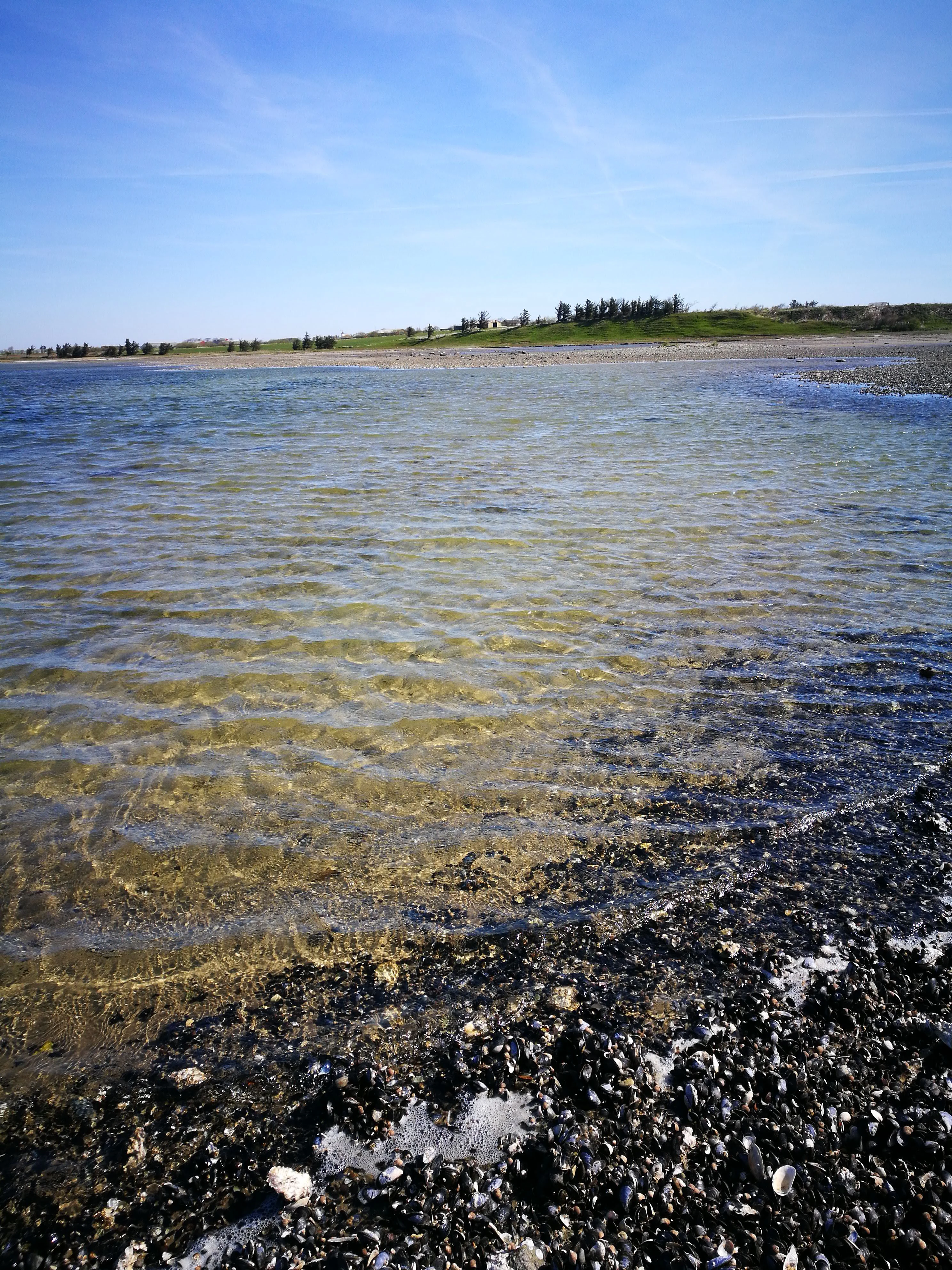
A vertical view of shallow, clear water lapping against a dark, pebbly shoreline, with a green coastline and blue sky in the background.
Shallow water along the rocky coast of Agerø.

Rudmose Aggerø conservation status and protection priorities

Rudmose Aggerø sits at the heart of one of the more ecologically significant protected marine and coastal complexes in the central Limfjorden. The surrounding waters form part of Natura 2000 area number 28, a combined habitat and bird protection site that also covers Agger Tange, Nissum Bredning, Skibsted Fjord, and Rudmose Aggerø itself. This designation is grounded in the area's shallow, sheltered seas, sandbanks, reefs, and sand flats, and in the bird populations that rely on them.

On land, the island hosts a dedicated nature reserve of approximately 27.5 hectares on its northwestern coast, owned and managed by the Danish Ornithological Protection Fund. This reserve is the principal vehicle of formal conservation on the island itself, complementing the broader marine protections by tying a portion of the terrestrial and shoreline environment directly into national bird conservation efforts. Together, the Natura 2000 marine designation and the reserve's shoreline protection give Rudmose Aggerø a layered conservation profile within what is otherwise a small inhabited farming island.

Rudmose Aggerø cultural meaning and human context

Culturally, Rudmose Aggerø is a small, long-established part of the Limfjorden's rural island life. With only around forty permanent residents, it retains the quiet character of many of Denmark's smaller fjord islands, where farming, fishing traditions, and small coastal communities have shaped the landscape for generations. A parish church on the island anchors local community life and reflects the long ecclesiastical history typical of Danish rural islands.

The island's cultural identity is inseparable from its broader Limfjorden context. For centuries the fjord has been both a highway and a barrier, joining and separating communities across northern Jutland, and Rudmose Aggerø has historically shared in this dual relationship, connected by water and, more recently, by causeway to neighboring Mors. Today it offers a glimpse of the kind of inhabited, working island landscape that has become increasingly rare in Denmark.

Top sights and standout views in Rudmose Aggerø

Rudmose Aggerø's strongest points of distinction lie in its protected marine environment and its conservation partnership with the Danish Ornithological Protection Fund. The island is a tangible, inhabited piece of one of the larger Natura 2000 complexes in the western Limfjorden, with both habitat and bird protection status in the surrounding waters.

Equally distinctive is the contrast itself: a quiet, low-lying farming island of only a few square kilometers that nonetheless sits within a regionally and nationally important network of protected shallow fjord habitats. The combination of causeway-linked rural island life and substantial formal environmental protection makes Rudmose Aggerø an unusually layered place within the Danish fjord landscape.

Best time to visit Rudmose Aggerø

The character of a visit to Rudmose Aggerø shifts gently with the seasons. Late spring and early summer bring longer days, calmer sea conditions, and active bird life across the fjord, making the shallow waters and sand flats especially lively. Summer also offers the most comfortable conditions on the water and along the low, exposed shorelines.

Autumn and winter carry their own appeal in this part of the Limfjorden, when migrant and wintering waterbirds concentrate around the protected shallow areas, and the soft horizontal light over the fjord gives the landscape a quieter, more open feel. Visitors interested primarily in birdlife will find the cooler months particularly rewarding, while those drawn to general coastal atmosphere may prefer the warmer, more forgiving season.

Monthly climate preview

Long-term representative monthly averages and temperature spans for Rudmose Aggerø

Rudmose Aggerø Climate Normals, Annual Temperature and Precipitation Rhythm

Historical NASA POWER data records a measured annual rhythm of monthly average temperatures and precipitation rates across a representative coordinate in Rudmose Aggerø. Examining the complete twelve-month climatology profile reveals detailed baseline variations in long-term temperature and moisture patterns.
Annual mean8 °C
1 °C17 °C
Jan
Feb
Mar
Apr
May11°
Jun14°
Jul17°
Aug17°
Sep14°
Oct
Nov
Dec
Warmest month
August

16.7 °C

Coolest month
February

1.2 °C

Wettest month
October

3.2 mm/day

Driest month
April

1.7 mm/day

Park location guide

Geography guide, regional context, and park location map for Rudmose Aggerø

Rudmose Aggerø park geography, regions, and map view in Denmark

Understand where Rudmose Aggerø sits in Denmark through a broader geographic reading of the surrounding landscape, nearby location context, and its mapped position within the national park landscape.

How Rudmose Aggerø fits into Denmark

Denmark is a constitutional monarchy and Nordic country in Northern Europe. It is the southernmost of the Scandinavian countries, bordering Germany to the south, Norway to the north, and Sweden to the southwest. The country consists of the Jutland peninsula and an archipelago of islands, with Copenhagen as its capital and largest city. Denmark has a population of over 6 million and is characterized by flat, arable land, sandy coasts, and a temperate climate.

Wider geography shaping Rudmose Aggerø in Denmark

Denmark occupies the Jutland peninsula and roughly 406 islands in Northern Europe. It is situated between the North Sea to the west and the Baltic Sea to the east. The country borders Germany to the south and is connected to Sweden via the Øresund Bridge. Denmark is predominantly flat terrain with low elevation, the highest point being Møllehøj at 170.86 meters.

Map view of Rudmose Aggerø

Use this park location map to pinpoint Rudmose Aggerø in Denmark, understand its exact geographic position, and read its mapped placement within the surrounding landscape more clearly.

Pigeon | © OpenStreetMap contributors

Location context for Rudmose Aggerø

Rudmose Aggerø

Visualizing the shallow marine habitats, sandbanks, and protected coastal environment of Rudmose Aggerø.

Rudmose Aggerø Photos and Scenery: Exploring the Lowland Fjord Landscape

Visual documentation reveals the soft, low-lying coastal terrain and intertidal sand flats defining the protected fjord ecosystem around Rudmose Aggerø. Studying these images helps observers understand the quiet interplay between working agricultural shores and vital bird conservation areas in northern Denmark.

A white church with a red tiled roof and a small tower, surrounded by a low brick wall, standing in a green field under a clear blue sky.

A wide landscape view showing a large green agricultural field in the foreground and midground, bordered by a hedge and white flowers, leading to a blue body of water and distant shoreline under a clear blue sky.

A vertical view of shallow, clear water lapping against a dark, pebbly shoreline, with a green coastline and blue sky in the background.

A wide landscape photograph showing rolling green fields with scattered trees in the foreground and midground, leading to a blue body of water and distant shoreline in the background.

Park atlas

Discover connected coastal habitats and regional fjord reserves across northern Denmark

Explore Other Parks Near Rudmose Aggerø and Surrounding Protected Landscapes

Browse protected areas and shallow marine reserves located close to Rudmose Aggerø in the Limfjorden. Comparing adjacent coastal landscapes provides deeper geographic context for regional bird protection networks.
Nature reserveRegion Nordjylland
About 4 km away#1 closest

North

Mågerodde og Karby Odde Nature Reserve: Coastal Protected Landscapes in Region Nordjylland

Limfjorden shoreline, shallow bays, and saline meadows.

Mågerodde og Karby Odde serves as a key coastal reserve in Denmark, defined by its extensive Limfjorden shoreline and complex mix of aquatic and terrestrial habitats. From saline meadows and coastal lagoons to acidic grasslands and spring-fed mires, this protected area offers a look at a diverse maritime ecosystem. The site is recognized for its importance to migratory waterfowl and breeding coastal birds, providing a essential link in the regional geography of the Limfjorden.

Area
4.97 km²
Established
2011
Relief
Lowland
Climate
Temperate
Protected areaDenmark
About 10 km away#2 closest

Southwest

Nissum Bredning Protected Area: Geography and Coastal Mapping in Denmark

Shallow bay ecosystems, glacial cliffs, and Limfjorden sand flats.

Nissum Bredning is a broad, low-lying basin in western Denmark known for its extensive shallow sand flats, including Fjordgrund and Gåseholm. The protected area encompasses a diverse coastal mosaic of brackish lagoons, salt meadows, and the distinctive Toftum Bjerge glacial cliff. This geography offers a clear view into the intersection of active North Sea currents and sheltered inland fjord environments.

Area
200 km²
Relief
Lowland
Climate
Temperate
Access
Easy access
A soft watercolor painting depicting a flat, open coastal landscape with rolling, pale-colored dunes in the distance and muted green grasses in the foreground against a white background.
Protected areaDenmark
About 14 km away#3 closest

West

Agger Tange Protected Area: Coastal Peninsula and Wetland Geography in Northwestern Denmark

Mapping the North Sea and Limfjorden interface

Agger Tange is a significant coastal landform in northwestern Denmark, characterized by its exposed western dunes and sheltered eastern salt marshes. This protected landscape documents the dramatic influence of storm surges on the Jutland coast, resulting in a complex network of lagoons and tidal flats that support critical bird habitats.

Area
24 km²
Established
1984
Relief
Lowland
Scope
Mixed
Watercolor illustration of a landscape with trees, water, and distant hills
National parkDenmark
About 17 km away#4 closest

North

Thy National Park: Explore Denmark's First Protected Coastal Landscape and Heathlands

Mapped dune systems, rare heath habitats, and coastal geography.

Thy National Park, Denmark's inaugural national park, protects a significant expanse of windswept coastal terrain. This area is renowned for its rare dune heaths, a habitat of particular European ecological importance, and a landscape shaped by a century of sand drift stabilization efforts. The park's diverse geography includes extensive sandy heaths, conifer plantations, and a striking coastline along the North Sea, offering rich opportunities for atlas exploration of protected natural areas and their surrounding regional context. Discover the mapped extent of this vital conservation landscape.

Area
244 km²
Established
2007
IUCN
II
Relief
Lowland
A soft, painterly watercolor illustration of a shallow lake landscape featuring gentle green grassy foreground, a calm body of water, and distant treelined hills under a pale, warm sky.
Protected areaRegion Nordjylland
About 19 km away#5 closest

Northwest

Ove Sø Protected Area: Geographic Overview of the Thy Wetland Landscape in Denmark

Mapped freshwater terrain in Region Nordjylland

Ove Sø features a long, shallow basin and complex wetland margins within the Thy landscape of Denmark. This entry provides a detailed look at the lake's hydrographic position, its connection to the Limfjorden system, and the protected status of its surrounding reed beds and meadow habitats.

Area
3.5 km²
Relief
Lowland
Scope
Terrestrial
Water
Water-dominated
Protected areaRegion Midtjylland
About 21 km away#6 closest

South

Natura 2000-område nr. 62 Veno, Veno Sund: Protected Coastal and Marine Landscape Map

Regional geography and protected coastal habitat overview

Analyze the protected area characteristics of Natura 2000-område nr. 62 Veno, Veno Sund, where shallow brackish sound meets dune heaths and calcareous grasslands. This site provides essential habitat for waders and marine mammals within the broader Limfjorden ecosystem in Region Midtjylland.

Area
29.26 km²
Established
2011
Relief
Lowland
Climate
Temperate
Protected areaDenmark
About 23 km away#7 closest

Northwest

Natura 2000-område nr. 43 Klitheder mellem Stenbjerg og Lodbjerg Coastal Heath Atlas

Denmark protected coastal dunes and heathland geography

Spanning over 2,900 hectares on the Danish coast, this protected area features a coherent sequence of active dunes, inland heathlands, and freshwater slacks. The site provides essential habitat for breeding cranes and rare flora, reflecting the complex ecological transitions of the Thy coastline. Use this reference to trace the regional boundaries and unique terrain features of this designated European habitat.

Area
29.18 km²
Water
Minor water
Protected areaRegion Midtjylland
About 26 km away#8 closest

Southeast

Skørsø Protected Area: Mapped Geography and Habitat Context in Region Midtjylland

Natural glacial basin and rare aquatic ecosystem in Central Denmark

The Skørsø site offers a detailed look at a rare clearwater, nutrient-poor lake basin formed by post-glacial processes. The protected area features a unique, unfragmented transition between open water and wet heath vegetation, serving as a critical refuge for specialized flora and protected wildlife within the cultivated landscape of Denmark.

Area
0.12 km²
Established
2011
Water
Major water bodies

Common questions about visiting, size, designation, and location context for Rudmose Aggerø

Rudmose Aggerø FAQs for park facts, access, geography, and protected area context

Find quick answers about Rudmose Aggerø, including protected-area facts, park geography, trail and visitor context, and how the park fits into its surrounding country and regional landscape.
MoriAtlas Explorer

Continue Your Protected Areas Search Across the Global Atlas

Deepen your exploration by continuing the structured search for national parks and protected areas worldwide. Utilize the comprehensive filtering capabilities to compare different conservation landscapes and refine your understanding of global park geography. Discover more about the distribution and characteristics of protected natural areas.

Global natural geography