

Mori Atlas logo
National parkSaddle Peak National Park

Discover the mapped boundaries and terrain of this vital national park in India.

Saddle Peak National Park: India's Protected Landscape and Geographic Context

Saddle Peak National Park represents a significant protected area within India's diverse geography. This page offers an atlas-centric view, detailing the park's specific location and mapped boundaries. Understand its role as a national park and explore its contribution to the regional landscape context, providing a foundation for structured geographic discovery.

tropical island parkendemic speciesmountain forestAndaman and Nicobar Islandssaltwater crocodile habitatendemic plants

Saddle Peak National Park

National park

Park overview

Structured park overview, official facts, and landscape profile for Saddle Peak National Park

Saddle Peak National Park park facts, protected area profile, and essential visitor context

Review the core facts for Saddle Peak National Park, including designation, size, terrain, visitor scale, habitats, and operating context in one park-focused overview.

About Saddle Peak National Park

Saddle Peak National Park occupies a meaningful position among India's national parks as a protected area on one of the most remote and ecologically significant island chains in the Bay of Bengal. The park was formally established in 1979, designation that brought formal protection to the forests surrounding Saddle Peak on North Andaman Island. This archipelago location, approximately 1,200 kilometers east of the Indian mainland, has resulted in evolutionary isolation that produced unique flora and fauna found nowhere else on Earth. The park's terrain centers on Saddle Peak, a prominent hill formation that rises from the island's interior, with the protected area extending across the slopes and surrounding lowland areas. The marine and coastal environments adjacent to the park boundaries add additional ecological zones to the protected landscape, including mangrove areas and shoreline habitats that support diverse species. Conservation of this area protects not only forest ecosystems but also the watershed functions that supply freshwater to local communities on the island.

Quick facts and research context for Saddle Peak National Park

Saddle Peak National Park is situated on North Andaman Island in the Andaman and Nicobar Islands union territory of India. The park was established in 1979 and covers 32.54 square kilometers around Saddle Peak, the highest point in the island group. The climate is oceanic with temperatures ranging from 20 to 30 degrees Celsius, and the monsoon season brings heavy rainfall from June through October. The park protects moist tropical vegetation and deciduous evergreen forest, with two endemic plant species, Scolopia pusilla and Cleistanthus robustus, found only in these islands and not on the Indian mainland.

Protection and recognition

Tracking regional management scope and terrestrial conservation status

Documented Protection Status and Boundaries of Saddle Peak National Park

National park seekers can explore the officially documented protection status and terrestrial conservation scope defined for Saddle Peak National Park. Verifying such structured designation parameters provides essential regional context for understanding how the park sits within broader global protected area frameworks.

Protection details

Protection scope
Terrestrial
Transboundary protection
No
Park context

Deeper park guide and search-rich context for Saddle Peak National Park

Saddle Peak National Park history, landscape, wildlife, and travel context

Explore Saddle Peak National Park through its history, landscape character, ecosystems, wildlife, conservation priorities, cultural context, and seasonal travel timing in a structured park guide built for atlas discovery and search intent.

Why Saddle Peak National Park stands out

Saddle Peak National Park is best known for protecting Saddle Peak, the highest mountain in the Andaman and Nicobar Islands, which dominates the landscape of North Andaman. The park is particularly notable for its endemic plant species, including Scolopia pusilla and Cleistanthus robustus, which are found only in these islands and represent botanical significance for conservation. The protected area also serves as a refuge for saltwater crocodiles, one of the largest living reptiles, which inhabit the coastal and wetland areas within and adjacent to the park boundaries. The combination of mountain forest, tropical vegetation, and coastal ecosystems makes this park a distinctive conservation area within the Indian subcontinent.

Saddle Peak National Park history and protected-area timeline

Saddle Peak National Park was established in 1979 as part of India's expanding network of protected areas during the late 20th century. The creation of the park reflected growing recognition of the Andaman and Nicobar Islands' ecological significance and the need to preserve unique island ecosystems from development pressures. The park was designated with the intention of protecting the forests around Saddle Peak, the dominant geographical feature of North Andaman Island. Prior to formal protection, the area had experienced logging and land conversion, and the establishment of the national park provided legal framework for safeguarding the remaining natural vegetation and wildlife. The park's IUCN category II designation places it among India's national parks that are managed primarily for ecosystem conservation and public recreation.

Saddle Peak National Park landscape and geographic character

The landscape of Saddle Peak National Park is defined by its mountainous terrain centered on Saddle Peak, which rises as the highest point in the Andaman and Nicobar Islands archipelago. The mountain and its surrounding slopes are covered in dense tropical vegetation that transitions from evergreen forest on the wetter slopes to semi-evergreen and deciduous forest types in drier areas. The park's terrain includes steep ridgelines descending from the peak, valleys that channel seasonal water flow, and lower slopes that approach coastal areas. The underlying volcanic geology of the Andaman island chain has shaped the landforms, with ancient volcanic rocks contributing to the soil conditions that support the lush vegetation. The overall visual character combines the dense green canopy of tropical forest with the stark rocky outcrops and exposed terrain that characterize the peak itself.

Saddle Peak National Park ecosystems, habitats, and plant life

The ecological character of Saddle Peak National Park reflects its location in a tropical island setting with moist conditions supporting luxuriant vegetation. The park contains moist tropical vegetation and deciduous evergreen forest that covers the slopes and valleys surrounding Saddle Peak. The forest supports a complex community of plant species adapted to the island's climate, with high humidity and abundant rainfall during the monsoon season. Two plant species of particular note occur within the park: Scolopia pusilla and Cleistanthus robustus, both endemic to the Andaman and Nicobar Islands and not found on the Indian mainland. This endemism makes the park botanically significant, as these species represent evolutionary lineages confined to this island group. The combination of forest types, from evergreen to semi-deciduous, creates a heterogeneous habitat that supports diverse ecological communities.

Saddle Peak National Park wildlife and species highlights

Saddle Peak National Park is home to several notable animal species that inhabit its forest and coastal environments. The Andaman wild pig is among the mammals found within the park, representing a subspecies adapted to island conditions. Birdlife includes the Andaman hill myna, a vocal and distinctive thrush known for its ability to mimic sounds, and the Andaman imperial pigeon, a large fruit-eating dove that feeds on forest fruits. The park's reptile fauna includes the saltwater crocodile, one of the world's largest reptiles, which occurs in coastal waters and mangrove areas bordering the protected area. Water monitors, large lizards that are skilled swimmers, also inhabit wetland areas within the park. Marine mammals including dolphins and whales are reported in the waters surrounding North Andaman Island, suggesting the park's coastal boundaries provide habitat for these species as well.

Saddle Peak National Park conservation status and protection priorities

Saddle Peak National Park plays an important role in conserving the unique ecosystems of the Andaman and Nicobar Islands, an archipelago with high levels of endemism. The protection of forest areas around Saddle Peak preserves habitat for endemic plant species and island-adapted wildlife populations. The park's designation as an IUCN Category II protected area reflects its primary management objective of ecosystem conservation, maintaining the natural forests and the species they support. The presence of endangered species such as the saltwater crocodile adds conservation significance, as this species faces threats from habitat loss and human conflict across its range. The protected status helps buffer the island's forest ecosystems from development pressures that might otherwise convert natural areas to agriculture or infrastructure. Maintaining connectivity between forest areas on North Andaman Island supports wildlife populations and preserves the ecological processes that sustain biodiversity in this isolated island setting.

Top sights and standout views in Saddle Peak National Park

Saddle Peak National Park protects the highest peak in the Andaman and Nicobar Islands, offering a mountainous backdrop to one of India's most remote island national parks. The park contains endemic plant species found nowhere else in the world, specifically Scolopia pusilla and Cleistanthus robustus, which are confined to these islands. Saltwater crocodiles inhabit the coastal areas bordering the park, representing one of the largest reptile species within India's protected areas. The combination of tropical forest, mountain terrain, and coastal ecosystems creates a diverse protected landscape on this isolated Indian Ocean archipelago.

Best time to visit Saddle Peak National Park

The best time to visit Saddle Peak National Park falls outside the monsoon season, with the period from November through April offering more favorable conditions for exploration. The monsoon season from June to October brings heavy rainfall to North Andaman Island, which can restrict access and make outdoor activities challenging. The pre-monsoon months of March and April feature warmer temperatures but generally clear conditions. Visitors should be aware that the park's remote island location requires travel by sea or air to reach the Andaman archipelago, and access within the park may be limited by infrastructure and seasonal conditions.
Monthly climate preview

Long-term temperature averages and monthly precipitation distributions for Saddle Peak National Park

Saddle Peak National Park Climate Normals and Annual Weather Patterns

Saddle Peak National Park records measured monthly temperature values alongside varying precipitation rates across the year at its representative coordinate. Reviewing the complete twelve-month profile provides deeper insight into long-term climate normals and annual environmental rhythms.
Annual mean28 °C
26 °C29 °C
Jan26°
Feb27°
Mar28°
Apr29°
May29°
Jun28°
Jul28°
Aug28°
Sep28°
Oct28°
Nov28°
Dec27°
Warmest month
April

29.3 °C

Coolest month
January

26.1 °C

Wettest month
July

13.6 mm/day

Driest month
February

0.4 mm/day

Park location guide

Geography guide, regional context, and park location map for Saddle Peak National Park

Saddle Peak National Park park geography, regions, and map view in India

Understand where Saddle Peak National Park sits in India through a broader geographic reading of the surrounding landscape, nearby location context, and its mapped position within the national park landscape.

How Saddle Peak National Park fits into India

India is a South Asian country bordered by the Indian Ocean, Arabian Sea, and Bay of Bengal. It shares land borders with Pakistan, China, Nepal, Bhutan, Bangladesh, and Myanmar. The country has a population of over 1.4 billion people and operates as a federal parliamentary republic with its capital in New Delhi.

Wider geography shaping Saddle Peak National Park in India

India occupies the Indian subcontinent in South Asia, bordered by the Arabian Sea to the southwest, the Bay of Bengal to the southeast, and the Indian Ocean to the south. It shares land borders with Pakistan to the west, China, Nepal, and Bhutan to the north, and Bangladesh and Myanmar to the east. The territory also includes the Andaman and Nicobar Islands in the Indian Ocean.

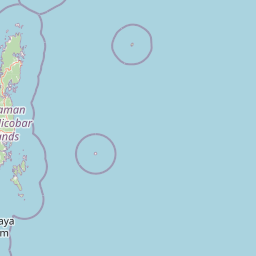
Map view of Saddle Peak National Park

Use this park location map to pinpoint Saddle Peak National Park in India, understand its exact geographic position, and read its mapped placement within the surrounding landscape more clearly.

Pigeon | © OpenStreetMap contributors

Location context for Saddle Peak National Park

Andaman and Nicobar Islands
Recorded earthquake history

Examine Recorded Seismic History Near Saddle Peak National Park

Explore the structured catalogue of historical earthquakes recorded within the proximity of Saddle Peak National Park. This resource offers a transparent look at regional seismic data, event magnitudes, and epicentre distances for those interested in the geographic history of this Andaman island protected area.

Saddle Peak National Park Earthquake History

Catalogued events

268 events

Strongest magnitude

Magnitude 6.5

Most recent event

Aug 21, 2024

This history includes earthquakes recorded inside the park or within 50 km of its borders

Park atlas

Trace the regional spread of protected landscapes, mapping connected conservation units across the Andaman and Nicobar Islands.

Discover More Protected Areas Near Saddle Peak National Park and its Tropical Island Geography

Browse a curated selection of national parks and protected areas located near Saddle Peak National Park, exploring the diverse conservation landscapes across the Andaman and Nicobar Islands archipelago. Compare their unique geographical contexts and ecological features to broaden your understanding of this remote Indian Ocean region's park distribution.
Wildlife reserveAndaman and Nicobar Islands
About 11 km away#1 closest

Southwest

Bamboo Island Wildlife Sanctuary: Mapping Coastal Protected Landscapes in the Andaman Archipelago

Coastal habitat, coral reefs, and littoral forest geography

Bamboo Island Wildlife Sanctuary represents a crucial protected area within the Andaman and Nicobar Islands, focusing on the interface between unique littoral bamboo thickets and surrounding marine reef environments. This reserve highlights the role of small island geography in conserving coastal stability and sensitive marine habitats within the Indian Bay of Bengal territory.

Area
0.05 km²
Established
1987
IUCN
IV
Relief
Lowland
Wildlife reserveAndaman and Nicobar Islands
About 23 km away#2 closest

North

Kwangtung Island Wildlife Sanctuary: Protected Forest and Shoreline Atlas

Geography and island habitat analysis in North Andaman.

Kwangtung Island Wildlife Sanctuary preserves a representative tropical island forest and coastal ecosystem in the North Andaman Islands. This wildlife reserve offers insight into the region's distinctive island-based conservation, featuring a dense mosaic of vegetation and marine-influenced margins that support a range of native Andaman fauna.

Area
0.57 km²
Established
1987
IUCN
IV
Relief
Lowland
Protected areaAndaman and Nicobar Islands
About 43 km away#3 closest

Southwest

Interview Island Protected Area: Geography, Forested Plateau, and Island Map

A remote wilderness sanctuary in the Andaman archipelago

Interview Island encompasses a secluded, 23 kilometer long landscape characterized by dense tropical forests and a rising southern plateau. This protected area stands out for its feral elephant population and near-undisturbed coastal environment, providing a compelling focus for geographic exploration and study of the Andaman island chain.

Area
101 km²
Established
1997
Relief
Upland
Water
Major water bodies
Wildlife reserveAndaman and Nicobar Islands
About 46 km away#4 closest

South

Cuthbert Bay Wildlife Sanctuary: Coastal Habitat and Sea Turtle Nesting Ground

Eastern Middle Andaman protected coastal geography

Cuthbert Bay Wildlife Sanctuary covers 5.8 square kilometres of critical coastal terrain along the eastern Middle Andaman coastline. Renowned for its concentration of sea turtle nesting beaches, the reserve supports diverse coastal ecosystems ranging from open sand to inland forest patches. It serves as a compact but vital ecological anchor within the broader landscape of the Andaman and Nicobar Islands.

Area
5.8 km²
Established
1997
IUCN
IV
Scope
Terrestrial
Wildlife reserveAndaman and Nicobar Islands
About 74 km away#5 closest

Southwest

Flat Island Wildlife Sanctuary: Protected Island Geography in the Andaman and Nicobar Islands

Coastal wildlife reserve and isolated island terrain

Flat Island Wildlife Sanctuary stands as a distinct, low lying protected area within the Andaman and Nicobar Islands. Its compact oval shape and shoreline focused landscape provide a clear example of the archipelago's small scale, uninhabited marine reserves. This protected island serves as a vital geographic marker for those mapping the diverse coastal habitats found across the Bay of Bengal.

Area
2.48 km²
Relief
Lowland
Climate
Tropical
Access
Remote access
National parkAndaman and Nicobar Islands
About 89 km away#6 closest

South

North Button Island National Park: Protected Landscape and Mapped Geographic Identity

Explore the mapped boundaries and regional natural terrain.

Gain a clear understanding of North Button Island National Park as a distinct protected landscape within the Andaman and Nicobar Islands region. This entry offers detailed geographic context, focusing on the park's mapped boundaries and its role within the archipelago's natural terrain. It serves as a foundational element for understanding this Indian National Park's place in a broader atlas of conservation areas.

Area
114 km²
Established
1979
National parkAndaman and Nicobar
About 94 km away#7 closest

South

Middle Button Island National Park: National Park within Andaman and Nicobar's Geography

Explore protected landscape context and mapped park boundaries.

Middle Button Island National Park represents a significant protected natural landscape, offering users a focused entry point for geographic discovery. As a designated national park, it contributes distinct mapped boundaries and terrain characteristics to the Andaman and Nicobar region's atlas data. Understanding its specific identity helps contextualize the broader protected-area network and regional geography. This page details the park's role as a conserved territory, vital for those seeking structured landscape and geography information.

Area
64 km²
Established
1979
Relief
Lowland
Climate
Tropical
National parkAndaman and Nicobar Islands
About 100 km away#8 closest

South

South Button Island National Park: Mapped Boundaries and Regional Protected Landscape

Key National Park in the Andaman and Nicobar Islands

South Button Island National Park is a protected natural area offering critical insight into the geography of the Andaman and Nicobar Islands. This detailed view focuses on its mapped boundaries and its significance as a national park within this Indian archipelago. Understanding its position within the regional geography provides essential context for exploring protected lands and natural landscapes across the Andaman and Nicobar Islands.

Area
5 km²
Relief
Lowland
Climate
Tropical
Access
Moderate access

Common questions about visiting, size, designation, and location context for Saddle Peak National Park

Saddle Peak National Park FAQs for park facts, access, geography, and protected area context

Find quick answers about Saddle Peak National Park, including protected-area facts, park geography, trail and visitor context, and how the park fits into its surrounding country and regional landscape.
MoriAtlas Explorer

Continue Your Protected Areas Search Across the Global Atlas

Deepen your exploration by continuing the structured search for national parks and protected areas worldwide. Utilize the comprehensive filtering capabilities to compare different conservation landscapes and refine your understanding of global park geography. Discover more about the distribution and characteristics of protected natural areas.

Global natural geography