Mori Atlas logo
National parkSan Lorenzo Marine Archipelago National Park

Discover this national park's distinct protected area identity within Baja California's regional context.

San Lorenzo Marine Archipelago National Park: Mapped Boundaries and Protected Landscape Geography

(Parque Nacional Marino Archipiélago de San Lorenzo)

San Lorenzo Marine Archipelago National Park stands as a significant protected landscape within the Baja California region, offering a unique focus for atlas-based exploration. This page details the park's identity as a national park, highlighting its mapped boundaries and contributing to a broader understanding of its protected area status. Engage with the geographic context of this remarkable natural reserve, designed for those seeking structured insights into the world's conservation lands and their mapped terrains.

Marine National ParkGulf of CaliforniaWhale WatchingSeabird ColoniesIsland EcosystemsDesert Islands

San Lorenzo Marine Archipelago National Park

National park

Park overview

Structured park overview, official facts, and landscape profile for San Lorenzo Marine Archipelago National Park

San Lorenzo Marine Archipelago National Park park facts, protected area profile, and essential visitor context

Review the core facts for San Lorenzo Marine Archipelago National Park, including designation, size, terrain, visitor scale, habitats, and operating context in one park-focused overview.

About San Lorenzo Marine Archipelago National Park

San Lorenzo Marine Archipelago National Park represents a critical marine conservation area in the Gulf of California, a region often called the "aquarium of the world" for its extraordinary marine biodiversity. The park was established in 2005 to protect the fragile and ecologically vital archipelago ecosystem, which supports a remarkable concentration of marine life including endangered species, commercially important fish populations, and internationally significant seabird nesting colonies. The park's marine waters are characterized by deep, cold, nutrient-rich conditions that support extensive marine food webs. The surrounding islands, though arid and lacking freshwater, provide essential terrestrial habitat for nesting seabirds and serve as protected breeding grounds for multiple endangered species. The archipelago's location in the central Gulf of California positions it at a critical juncture where oceanic currents create highly productive fishing grounds. The Mexican federal government designated this area for protection under NOM-059-SEMARNAT-2001 due to the presence of numerous species classified as threatened, vulnerable, or endangered. Beyond its ecological significance, the area holds importance for commercial and recreational fishing, cultural activities, and increasingly for sustainable tourism centered on whale watching and wildlife observation.

Quick facts and research context for San Lorenzo Marine Archipelago National Park

The park is located in the Gulf of California within the municipality of Mexicali, Baja California, Mexico. It was established by national decree on April 25, 2005, making it one of Mexico's more recently designated national parks. The terrestrial portion consists of rugged volcanic islands with elevations reaching 485 meters on San Lorenzo Island. The surrounding waters are deep, cold, and nutrient-rich, supporting over 800 fish species and 2,000 invertebrate species. The islands serve as critical nesting sites for seabirds including Heermann's gull and elegant tern, which represent approximately 95% of their respective world populations.

Protection and recognition

Documenting the marine boundary protection scope and official 2005 designation history within the archipelago.

San Lorenzo Marine Archipelago National Park Protection Status and Official Designation

San Lorenzo Marine Archipelago National Park features a dedicated marine protection scope established in 2005 to safeguard the regional aquatic geography. Understanding formal marine designation frameworks helps researchers trace the legal conservation history of critical island habitats.

Protection details

Protection scope
Marine
Designated year
2005
Transboundary protection
No
Park context

Deeper park guide and search-rich context for San Lorenzo Marine Archipelago National Park

San Lorenzo Marine Archipelago National Park history, landscape, wildlife, and travel context

Explore San Lorenzo Marine Archipelago National Park through its history, landscape character, ecosystems, wildlife, conservation priorities, cultural context, and seasonal travel timing in a structured park guide built for atlas discovery and search intent.

Why San Lorenzo Marine Archipelago National Park stands out

San Lorenzo Marine Archipelago is best known for its extraordinary marine mammal populations and globally significant seabird colonies. The surrounding waters provide critical habitat for endangered blue whales, humpback whales, killer whales, and sperm whales. Rasa Island hosts one of the largest seabird nesting colonies in the Gulf of California, supporting approximately 260,000 Heermann's gulls and 200,000 elegant terns, representing roughly 95% of each species' total world population. The archipelago also serves as important nesting habitat for brown pelicans and supports populations of endangered sea turtles including green, hawksbill, and olive ridley turtles.

San Lorenzo Marine Archipelago National Park history and protected-area timeline

San Lorenzo Marine Archipelago National Park was formally established through a national decree signed on April 25, 2005, making it one of Mexico's more recently created protected areas. The creation of this marine national park responded to growing scientific recognition of the archipelago's exceptional ecological importance within the Gulf of California and the urgent need to protect its fragile marine ecosystems. The decree designated approximately 50,442 hectares of maritime area surrounding the San Lorenzo archipelago for protection, with the explicit goals of preserving marine ecosystems and regulating the sustainable use of aquatic flora and fauna. Prior to formal protection, the area faced increasing pressure from commercial fishing and other human activities that threatened the sensitive species populations inhabiting these waters. The establishment of the park reflected Mexico's commitment to fulfilling international conservation obligations and protecting critical habitat for endangered marine species that depend on the Gulf of California's unique ecological conditions.

San Lorenzo Marine Archipelago National Park landscape and geographic character

The San Lorenzo Marine Archipelago consists of five main islands: San Lorenzo, Las Animas, Salsipuedes, Rasa, and Partida, surrounded by their maritime waters in the central Gulf of California. The terrestrial portions of these islands are characterized by rugged, arid terrain with dramatic topographic relief. San Lorenzo Island, the largest in the archipelago, rises to approximately 485 meters above sea level at its southern end, creating a prominent landmark in the Gulf. The islands feature irregular coastlines eroded by sea action, forming numerous sea cliffs and rocky shores. Despite their proximity to the Pacific, these islands experience a hot desert climate with extremely limited rainfall, averaging only about 2.54 inches annually. The lack of freshwater resources has resulted in sparse terrestrial vegetation, with only desert shrubs and cactus able to survive on the islands. The surrounding marine environment contrasts sharply with the terrestrial conditions, as the deep waters around the archipelago are cold, nutrient-rich, and highly productive.

San Lorenzo Marine Archipelago National Park ecosystems, habitats, and plant life

The marine environment of San Lorenzo Marine Archipelago supports one of the most biodiverse ecosystems in the Gulf of California, often considered one of the world's most productive marine regions. The nutrient-rich waters, enhanced by seasonal wind patterns that bring cold, fertile waters from the Pacific Ocean in winter, support more than 800 species of fish and 2,000 species of invertebrates. The marine food web centers on extensive kelp forests and algal communities that provide habitat and nutrition for smaller marine organisms, which in turn support larger predators and seabird populations. The islands' arid terrestrial environment supports only limited vegetation, primarily desert shrubs and cactus adapted to extreme drought conditions. However, the surrounding waters support diverse marine flora including various algae species that form critical habitat structures for juvenile fish and invertebrates. The archipelago's position in the central Gulf places it at a biogeographic crossroads, contributing to its exceptional species diversity and the presence of both tropical and temperate marine species.

San Lorenzo Marine Archipelago National Park wildlife and species highlights

San Lorenzo Marine Archipelago supports remarkable marine wildlife diversity, including several endangered species that depend on these waters for feeding, breeding, or migration. The archipelago is a critical habitat for blue whales, humpback whales, killer whales, and sperm whales, with blue whales particularly known to frequent the area during winter months. Endangered sea turtles regularly occur in the surrounding waters, including green turtles, hawksbill turtles, and olive ridley turtles. The totoaba, a large marine fish endemic to the Gulf of California, also inhabits these waters. Commercially important fish species include swordfish and hake, while Risso dolphins are commonly observed in the area. The islands provide exceptional seabird nesting habitat, with Rasa Island supporting globally significant colonies of Heermann's gull and elegant tern. Brown pelicans nest on Salsipuedes, Las Animas, and San Lorenzo islands, with an estimated 6,000 to 18,000 nesting pairs across these three islands. The archipelago also supports migratory birds including Cooper's hawk, golden eagle, peregrine falcon, magnificent frigatebird, and Nazca booby.

San Lorenzo Marine Archipelago National Park conservation status and protection priorities

San Lorenzo Marine Archipelago National Park holds exceptional conservation significance as one of the most important ecological areas in the Gulf of California. The Mexican government designated this area for protection under NOM-059-SEMARNAT-2001 due to the presence of numerous species classified under various risk categories. The park protects critical habitat for some of the world's most endangered marine species, including blue whales, which are considered endangered globally, and several species of sea turtles that face significant population declines. The seabird colonies on Rasa Island represent extraordinary conservation value, as the Heermann's gull and elegant tern populations nesting here account for approximately 95% of each species' total global population, making the archipelago essential for the survival of these birds. The marine ecosystem supports important commercial and recreational fishing resources, and protection of this area helps maintain sustainable fish populations that are vital to the regional economy. The park's designation as a marine national park reflects Mexico's commitment to preserving the Gulf of California's unique biodiversity and ecological processes.

San Lorenzo Marine Archipelago National Park cultural meaning and human context

The San Lorenzo Archipelago falls within the municipal jurisdiction of Mexicali in Baja California, Mexico. The islands have historically served as important resources for surrounding coastal communities, supporting commercial and recreational fishing activities that form part of the regional cultural and economic identity. The archipelago's separation from the mainland by the Salsipuedes Channel has contributed to its relative isolation and the preservation of its ecological integrity. Traditional maritime activities, including fishing and more recently wildlife observation tourism, have shaped human relationships with this marine environment. The area's significance extends beyond its immediate regional context to national conservation priorities, as evidenced by its designation as a federal protected area.

Top sights and standout views in San Lorenzo Marine Archipelago National Park

The San Lorenzo Marine Archipelago stands out for its extraordinary concentration of marine life and global significance for seabird conservation. The protected waters host regular congregations of blue whales, humpback whales, and other marine mammals, making whale watching a major draw for visitors. Rasa Island's seabird colonies represent one of the most important nesting sites in the Eastern Pacific, with Heermann's gull and elegant tern populations that are essentially irreplaceable on a global scale. The dramatic contrast between the arid island landscapes and the vibrant marine environment creates a distinctive visual experience. The archipelago's position in the central Gulf of California places it in one of the world's most productive marine ecosystems, where nutrient-rich waters support remarkable biodiversity.

Best time to visit San Lorenzo Marine Archipelago National Park

The optimal time to visit San Lorenzo Marine Archipelago National Park coincides with the winter months when whale activity peaks in the Gulf of California. Between December and March, blue whales and humpback whales are commonly observed in the surrounding waters, making this period particularly popular for whale watching excursions. The summer months of July and August bring the hottest conditions, with temperatures ranging from 95°F to 104°F, while winters remain warm with lows around 52°F. The dry desert climate means that rainfall is minimal throughout the year, so visitors should expect consistently sunny conditions. Winds are a significant factor affecting sea conditions, with calmer waters typically prevailing during the summer months, though the intense heat may make outdoor activities less comfortable.

Monthly climate preview

Decades of historical averages detailing the annual temperature and precipitation trends in Baja California

San Lorenzo Marine Archipelago National Park Climate Normals and Weather by Month

Climatology records for San Lorenzo Marine Archipelago National Park show mean temperatures ranging from a cool 15.98 degrees Celsius up to a warm 30.32 degrees Celsius. Expanding the complete historical dataset reveals monthly precipitation trends and seasonal variances across the marine ecosystem.
Annual mean22 °C
16 °C30 °C
Jan16°
Feb16°
Mar18°
Apr19°
May22°
Jun26°
Jul29°
Aug30°
Sep29°
Oct25°
Nov21°
Dec17°
Warmest month
August

30.3 °C

Coolest month
January

16 °C

Wettest month
September

0.7 mm/day

Driest month
May

0 mm/day

Park location guide

Geography guide, regional context, and park location map for San Lorenzo Marine Archipelago National Park

San Lorenzo Marine Archipelago National Park park geography, regions, and map view in Mexico

Understand where San Lorenzo Marine Archipelago National Park sits in Mexico through a broader geographic reading of the surrounding landscape, nearby location context, and its mapped position within the national park landscape.

How San Lorenzo Marine Archipelago National Park fits into Mexico

Mexico, officially the United Mexican States, is a country in North America spanning the Sierra Madre mountain ranges, coastal plains, and tropical regions. It borders the United States to the north, Guatemala and Belize to the southeast, and has coastlines along the Pacific Ocean, Gulf of Mexico, and Caribbean Sea. With a population exceeding 130 million, Mexico is home to one of the world's most significant concentrations of Indigenous languages alongside Spanish.

Wider geography shaping San Lorenzo Marine Archipelago National Park in Mexico

Mexico occupies a land area of 1,972,550 km2, making it the thirteenth-largest country in the world. The terrain is highly diverse, featuring the Sierra Madre Occidental and Sierra Madre Oriental mountain ranges, the Mexican Plateau, coastal lowlands along the Pacific and Gulf/Caribbean margins, and the Yucatan Peninsula. The country spans multiple climate zones from desert in the north to tropical rainforest in the south.

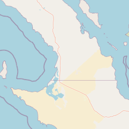
Map view of San Lorenzo Marine Archipelago National Park

Use this park location map to pinpoint San Lorenzo Marine Archipelago National Park in Mexico, understand its exact geographic position, and read its mapped placement within the surrounding landscape more clearly.

Pigeon | © OpenStreetMap contributors

Location context for San Lorenzo Marine Archipelago National Park

Baja CaliforniaMexicali Municipality
Park atlas

Compare marine and island protected areas across the Gulf of California, exploring regional park geography.

Discover Nearby National Parks and Protected Areas Around San Lorenzo Marine Archipelago National Park

After exploring San Lorenzo Marine Archipelago National Park, continue your discovery by browsing other national parks and protected areas in the surrounding Gulf of California and Baja California region. Compare diverse marine environments, arid island ecosystems, and coastal conservation landscapes to gain valuable geographic context for these critical protected areas.
Biosphere reserveBaja California
About 58 km away#1 closest

West

Bahía de los Ángeles Biosphere Reserve: Geography and Protected Area Atlas

Coastal desert, volcanic islands, and Sea of Cortez marine channels

Spanning 1,500 square miles, this biosphere reserve preserves the dramatic transition from the arid Baja California desert to the deep, productive waters of the Gulf of California. The protected area encompasses a diverse chain of volcanic islands, including Isla Ángel de la Guarda, and supports high biological productivity driven by deep submarine canyons and marine currents.

Area
3,879.56 km²
Established
2007
Relief
Mixed relief
Climate
Arid
Nature reserveSonora
About 80 km away#2 closest

Southeast

Isla San Pedro Mártir Nature Reserve: Mapping the Geography of the Gulf of California

Isolated rocky terrain and productive marine sanctuary

Isla San Pedro Mártir serves as a distinct protected area marked by its extreme isolation and dramatic vertical cliffs. The reserve acts as a core seabird nesting site supported by nutrient-rich cold-water upwellings in the Gulf of California, providing a vital example of arid island and marine geography.

Area
2.729 km²
Scope
Mixed
Marine protected areaMexico
About 130 km away#3 closest

Southeast

Gulf of California: Marine Protected Area and Volcanic Geography of the Pacific Basin

Mapping protected islands and deep-sea terrain in Mexico

The Gulf of California represents a critical marine protected area defined by its tectonic youth and biological complexity. From the northern delta zones to the tropical southern waters, this basin offers a rare look at how submarine rifting and arid coastal geography influence marine habitat development. Explore its distribution of volcanic islands, deep canyons, and tidal environments through our detailed geographic records.

Area
177,000 km²
Established
2005
Relief
Mixed relief
Climate
Subtropical
Protected areaBaja California Sur
About 209 km away#4 closest

South

San Ignacio Lagoon: Protected Coastal Desert Geography in Baja California Sur

Coastal lagoons, tidal channels, and desert ecosystems.

Examine the geographic boundaries and landscape features of San Ignacio Lagoon. This protected coastal nursery provides a rare desert-to-sea interface, characterized by shallow tidal flats, narrow channels, and expansive arid terrain within the Baja California Peninsula.

Area
175 km²
Established
2004
Relief
Lowland
Climate
Arid
Wildlife reserveBaja California
About 253 km away#5 closest

Northwest

Valle de los Cirios Wildlife Reserve: Mapped Geography and Protected Desert Landscapes

Exploring the diverse arid terrain of the Baja California peninsula

Valle de los Cirios represents a premier protected landscape in Mexico, characterized by its iconic cirio cactus woodlands and deep mountain sierras. The reserve connects vast stretches of desert habitat from the Pacific coast to the Gulf of California, creating a unique geographic corridor for endemic species and wide-ranging desert mammals.

Area
25,217.8 km²
Established
1980
Relief
Mountain
Climate
Arid
Watercolor painting of a mountainous landscape with pine trees, rolling hills, and a pastel sky
National parkBaja California
About 338 km away#6 closest

Northwest

Sierra de San Pedro Mártir National Park: Protected Landscape and Geographic Exploration

National park boundaries and natural terrain in Baja California.

Sierra de San Pedro Mártir National Park is a vital protected landscape situated in Baja California. This destination offers users a focused atlas exploration of its national park status, detailing its geographic setting and mapped protected area. Understand the park's specific place within the region, examining its natural terrain and boundaries for a clear geographic context, essential for any structured discovery of Mexico's conserved lands.

Area
729.09 km²
Established
1947
IUCN
II
Relief
Mountain
Wildlife reserveSonora
About 369 km away#7 closest

Northeast

Bavispe Flora and Fauna Protection Area: Sierra Madre Occidental Mountain Geography

Mapped protected forest tracts across Sonora ranges

Spanning five distinct mountain tracts in Sonora, this wildlife reserve preserves rare pine-oak forest communities within the Sierra Madre Occidental. Learn how these ridges and basins act as a vital hydrological anchor for the Yaqui River and provide critical corridors for wildlife through the diverse, transition-heavy terrain of northern Mexico.

Area
2,009 km²
Established
1936
IUCN
VI
Relief
Mountain
National parkBaja California Sur
About 372 km away#8 closest

Southeast

Bahía de Loreto National Park: National Park Protected Landscape and Geographic Identity

Explore its mapped boundaries and regional context.

Bahía de Loreto National Park offers a distinct focus on its protected natural landscape and geographic features within Baja California Sur. This destination provides detailed mapping and regional context, enabling a focused exploration of its boundaries and natural environment. It is ideal for users seeking to understand the specific protected area identity and its geographical placement as part of a broader atlas of conservation landscapes.

Area
2,065.81 km²
Established
1996
IUCN
II
Relief
Mixed relief

Common questions about visiting, size, designation, and location context for San Lorenzo Marine Archipelago National Park

San Lorenzo Marine Archipelago National Park FAQs for park facts, access, geography, and protected area context

Find quick answers about San Lorenzo Marine Archipelago National Park, including protected-area facts, park geography, trail and visitor context, and how the park fits into its surrounding country and regional landscape.
MoriAtlas Explorer

Continue Your Protected Areas Search Across the Global Atlas

Deepen your exploration by continuing the structured search for national parks and protected areas worldwide. Utilize the comprehensive filtering capabilities to compare different conservation landscapes and refine your understanding of global park geography. Discover more about the distribution and characteristics of protected natural areas.

Global natural geography