
Mori Atlas logo
Nature reserveSaumain in der Stadt Schweinfurt

A rare urban nature reserve protecting river dynamics and riparian woodland in Bavaria

Saumain in der Stadt Schweinfurt Nature Reserve: Mapping the Protected River Main Floodplain

(Naturschutzgebiet Saumain in der Stadt Schweinfurt)

Saumain in der Stadt Schweinfurt serves as a vital nature reserve and ecological refuge within the industrial cityscape of Schweinfurt. This protected area preserves a unique, regulated arm of the River Main, featuring diverse aquatic zones, reed beds, and riparian forest habitats. Through this atlas entry, discover the geographic boundaries and landscape character of this significant Bavarian floodplain site, which remains a key component of the broader Maintal bird protection area.

nature reserveurban nature reserveriver armMain riverfloodplain habitatriparian woodland
A flat, vector-style illustration of a winding river flowing through a lush green valley at sunset, with low mountains or cliffs in the background.

Saumain in der Stadt Schweinfurt

Nature reserve

Park overview

Structured park overview, official facts, and landscape profile for Saumain in der Stadt Schweinfurt

Saumain in der Stadt Schweinfurt park facts, protected area profile, and essential visitor context

Review the core facts for Saumain in der Stadt Schweinfurt, including designation, size, terrain, visitor scale, habitats, and operating context in one park-focused overview.

About Saumain in der Stadt Schweinfurt

Saumain in der Stadt Schweinfurt is a compact, ecologically focused nature reserve situated in the southern part of the city of Schweinfurt, in the Stadtteil Hafen-Ost. Despite being embedded in a large urban agglomeration, the reserve preserves a stretch of near-natural river landscape that has largely disappeared from the heavily regulated Main river corridor further downstream. Its roughly 11.57 hectares include the waters of an old Main arm, the steep reinforced embankments flanking it, narrow flat-shore zones on the southern side, several vegetated islands, and transitions into the adjacent Schweinfurt Stadtpark with its historic fortifications.

The reserve's hydrology is one of its defining features. A lock and weir system isolates the Saumain arm from the heavily navigated main flow of the River Main, protecting it from the sharp water level changes that shipping traffic would otherwise impose. A controllable inflow regulates the water level, leaving some sections with measurable current while other zones take on a still-water character. The arm also serves as a flood retention basin, absorbing excess water during high-flow events. This combination of regulated but ecologically calm water conditions supports the development of aquatic and riparian habitats that have become rare along larger German river systems.

Ecologically, the reserve is characterized by overlapping zones of open water, floodplain vegetation, and embankment communities. The still zones host Schwimmblattgesellschaften with yellow water lily and floating pondweed, while the islands support extensive Schilf-Röhrichte (common reed beds) and tall-herb flood meadows. The embankment edges carry a mix of Weichholzauen species such as white willow, basket willow, and black poplar alongside Hartholzauen species including pedunculate oak, wych elm, and European elm, with ash and alder appearing across the wetter zones. Although neophytes such as Indian balsam are noted as spreading under the nutrient-rich conditions, the site still functions as an important refuge for floodplain plant communities and as a stepping-stone within the wider Main valley ecosystem.

The area also has cultural and historical context, since part of the reserve extends into the historic Stadtpark and the old defensive works that once protected Schweinfurt. The Cramer Mühle, a historic mill, borders the northern edge of the site. Surrounding protected areas, including the larger LSG Schweinfurt landscape protection area and the ecologically valuable Spitalholz bei Gochsheim reserve, reinforce Saumain's role as an anchor point in a broader network of floodplain and forest conservation along the Main.

Quick facts and research context for Saumain in der Stadt Schweinfurt

Designated as a Naturschutzgebiet (nature reserve) in 1993, Saumain in der Stadt Schweinfurt is the only formally protected nature reserve within the city of Schweinfurt. The reserve covers about 11.57 hectares and lies within the Verdichtungsraum Schweinfurt, a densely populated agglomeration zone in Lower Franconia, Bavaria. It is managed by the Untere Naturschutzbehörde der Stadt Schweinfurt and is registered under the designation NSG-00458.01 and WDPA ID 165338. The area is part of the larger Maintal zwischen Schweinfurt und Dettelbach bird protection area, which adds an EU-level bird conservation context to the small local reserve.

Protection and recognition

Review documented terrestrial protection scope and baseline administrative records.

Saumain in der Stadt Schweinfurt Protection Status and Designation Data

Saumain in der Stadt Schweinfurt holds a documented terrestrial protection status within global conservation databases. Official records outline the verified designation scope and baseline administrative metrics for this protected area.

Protection details

Protection scope
Terrestrial
Transboundary protection
No
WDPA ID
165338
Park context

Deeper park guide and search-rich context for Saumain in der Stadt Schweinfurt

Saumain in der Stadt Schweinfurt history, landscape, wildlife, and travel context

Explore Saumain in der Stadt Schweinfurt through its history, landscape character, ecosystems, wildlife, conservation priorities, cultural context, and seasonal travel timing in a structured park guide built for atlas discovery and search intent.

Why Saumain in der Stadt Schweinfurt stands out

Saumain is best known for protecting an old, isolated arm of the River Main that retains near-natural river dynamics within an otherwise highly urbanized setting. The reserve is particularly valued for its combination of slow-flowing and still-water zones, reed-covered islands, floating-leaved aquatic vegetation, and a mosaic of softwood and hardwood floodplain woodland along its banks. Its designation as the sole nature reserve within Schweinfurt city limits and its inclusion in an EU bird protection area give it an outsized ecological significance relative to its compact size.
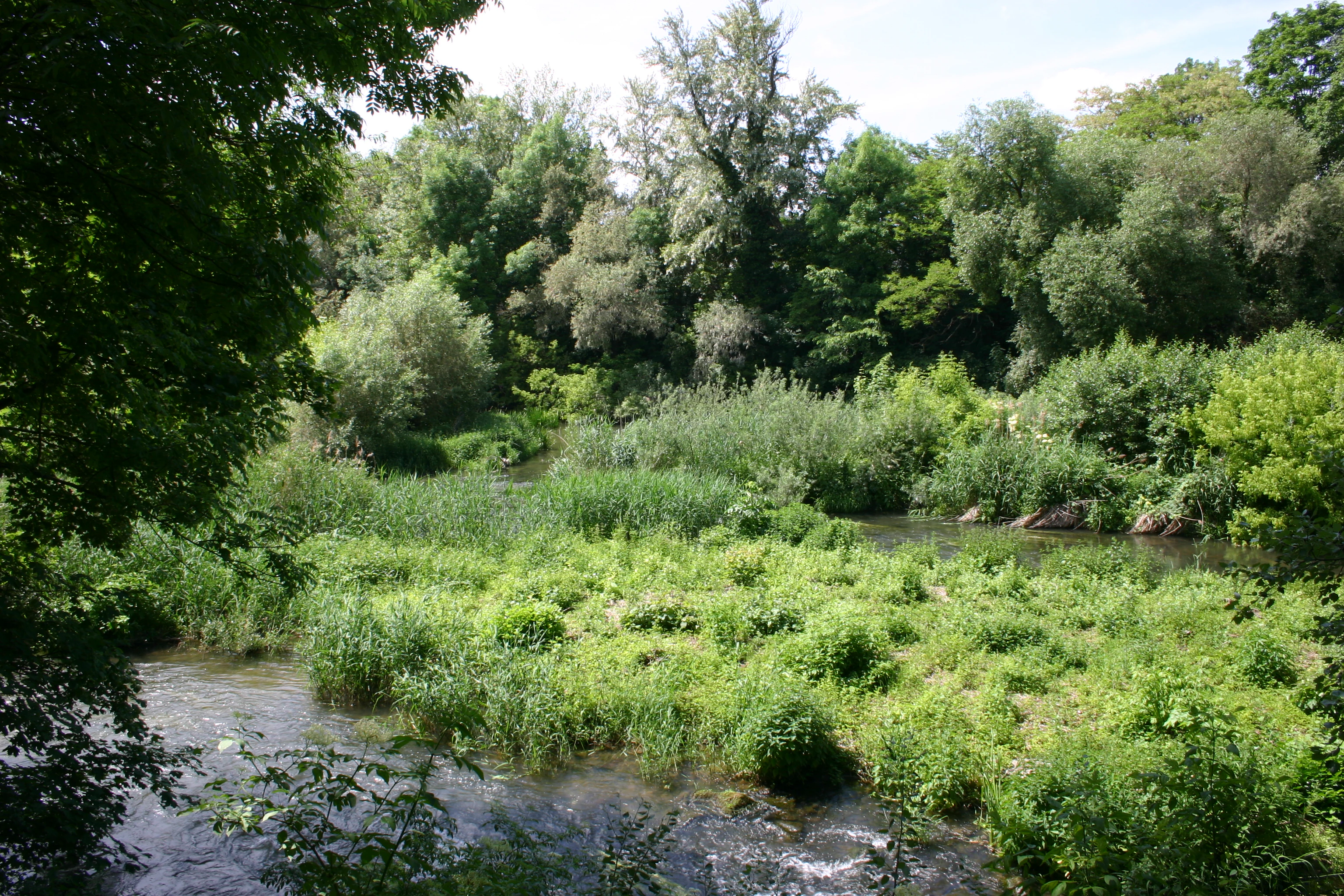
A green, wooded river scene showing a side arm of the Main river with lush vegetation, reeds, and trees.
A view of the Saumain river arm within the nature reserve in Schweinfurt.

Saumain in der Stadt Schweinfurt history and protected-area timeline

Saumain in der Stadt Schweinfurt was formally designated as a Naturschutzgebiet in 1993, becoming the only nature reserve within the independent city of Schweinfurt. Its establishment came as part of broader efforts in Bavaria and Lower Franconia to preserve remaining near-natural stretches of the Main river system, many of which had been lost to navigation regulation, flood control engineering, and urban expansion.

Prior to protection, the site existed as an old Main arm that was partially cut off from the main river by hydraulic infrastructure, including a lock and weir system designed to manage flow and protect the arm from shipping-induced water level changes. Over time, this infrastructure inadvertently created conditions favorable to floodplain vegetation, still-water communities, and riparian woodland.

The reserve's administrative identity is tied to the Untere Naturschutzbehörde der Stadt Schweinfurt, which continues to oversee its management. A formal biotope survey in 2002 documented four distinct habitat types within the small area, helping to establish a baseline for ongoing monitoring and habitat protection. Its later inclusion in the EU-level Maintal zwischen Schweinfurt und Dettelbach bird protection area added an international layer of conservation status to what had begun as a municipal nature reserve.

Saumain in der Stadt Schweinfurt landscape and geographic character

The landscape of Saumain in der Stadt Schweinfurt is shaped primarily by water. The central feature is an old, regulated arm of the River Main, separated from the shipping channel by a lock and weir system that stabilizes water levels around 204 to 209 meters above sea level. The arm combines flowing sections near the inflow with slower, almost still zones further along, producing a varied aquatic character within a very compact footprint.

Along the edges of the water body, the banks rise as steep, reinforced embankments, characteristic of engineered Main valley flood infrastructure. On the southern side, however, the topography softens: a narrow flat-shore zone and a roughly five-meter-wide bank terrace provide gentler transitions between water and land. Within the open water, several small islands rise above the surface, breaking up the channel and creating sheltered microhabitats.

Beyond the water and embankments, the reserve blends into the surrounding urban Schweinfurt landscape. Part of the area extends into the Schweinfurt Stadtpark and the city's historic defensive structures, while the wider surroundings include the industrial and residential districts of Hafen-Ost and Hafen-West, the neighboring community of Sennfeld to the east, and the more rural fringes of Gochsheim to the south. The result is a distinctive landscape where engineered river infrastructure, floodplain vegetation, and urban parkland meet within a few hundred meters.

Saumain in der Stadt Schweinfurt ecosystems, habitats, and plant life

The nature of Saumain is dominated by floodplain and aquatic ecosystems despite the reserve's very small size. The combination of regulated flow, sheltered still-water sections, and varied banks creates conditions for a layered ecological structure: open water surfaces, islands, shallow waters, reed beds, tall-herb communities, and mixed riparian woodland.

In the calmer water zones, Schwimmblattgesellschaften flourish, with yellow water lily and floating pondweed forming floating-leaved plant communities typical of lowland river floodplains. The islands and shallow margins support extensive Schilf-Röhrichte (common reed beds) and feuchte Hochstaudenfluren (wet tall-herb meadows), which together cover much of the non-open-water area. Peripheral wet zones host moisture-loving species such as purple loosestrife, hemp agrimony, and shore wolf's bane.

The riparian woodland shows the characteristic two-layer structure of Central European floodplain forests. Along the base of the embankments and in flatter sections, Weichholzauen species dominate, including white willow, basket willow, and black poplar, all adapted to periodic flooding and sediment deposition. In slightly higher or more stable zones, Hartholzauen species such as pedunculate oak, wych elm, European elm, common ash, and black alder form a more diverse upper canopy. The documented biotope mapping from 2002 records vegetation-free open water as the largest habitat type, followed by water-adjacent woodlands, wet tall-herb meadows, and large reed beds; together, these four biotope types capture the reserve's principal ecological character.

A noted pressure on the ecosystem is the spread of neophytes, particularly Indian balsam, which thrives under nutrient-rich conditions and can displace higher-value native vegetation along the banks. This makes ongoing management of nutrient inputs and invasive species a recurring concern for the reserve's ecological integrity.

Saumain in der Stadt Schweinfurt wildlife and species highlights

Although the source material does not document specific animal species in detail, the inclusion of Saumain in the EU-designated Maintal zwischen Schweinfurt und Dettelbach bird protection area indicates that the reserve has recognized significance for birdlife along the Main valley. The combination of open water, reed-covered islands, still-water zones with extensive floating vegetation, and adjacent softwood and hardwood riparian woodland provides habitat for waterbirds, reed-dependent species, and woodland birds typical of Central European floodplain landscapes.

The reed beds and tall-herb meadows on the islands and along the flat southern shore offer nesting and foraging habitat for typical wetland bird species, while the surrounding trees and shrubs support insect populations and the bird and small mammal communities associated with floodplain forests. The proximity to the larger Main river system also enhances the reserve's role as a refuge and movement corridor for fauna moving through the urban Schweinfurt landscape.

Saumain in der Stadt Schweinfurt conservation status and protection priorities

Conservation significance at Saumain in der Stadt Schweinfurt operates on multiple scales. Locally, the reserve preserves a near-natural Main arm with associated floodplain vegetation within a heavily urbanized area, providing one of the few unhurried ecological pockets in the city. Its designation as a Naturschutzgebiet since 1993 protects the site from further alteration of its water regime and land cover, and the Untere Naturschutzbehörde der Stadt Schweinfurt is responsible for ongoing management.

Regionally, the reserve forms part of a network of protected areas along the Schweinfurt stretch of the Main valley, sitting alongside the larger LSG Schweinfurt landscape protection area to the east and the ecologically valuable Naturschutzgebiet Spitalholz bei Gochsheim to the south. At the European level, its inclusion in the Vogelschutzgebiet Maintal zwischen Schweinfurt und Dettelbach connects it to the EU Birds Directive framework, giving it transboundary relevance for protected bird species using the Main corridor.

The reserve also functions as a regeneration space for adjacent Main sections, offering a buffer and source area from which plant and animal communities can recolonize neighboring stretches. The principal conservation challenge is the spread of invasive neophytes, especially Indian balsam, under nutrient-rich conditions, which requires active habitat management to maintain the integrity of the native floodplain flora. Protecting the regulated hydrology of the arm against further infrastructure pressures also remains a central concern.

Saumain in der Stadt Schweinfurt cultural meaning and human context

The cultural context of Saumain in der Stadt Schweinfurt reflects the layered history of Schweinfurt as a Main valley city. Part of the reserve extends into the Schweinfurt Stadtpark and the city's historic defensive works (Wehranlagen), connecting the ecological site directly with the city's older urban fabric and its historic fortification landscape. The Cramer Mühle, a historic mill located at the northern edge of the reserve, ties the site to the long-standing milling and water-management history that shaped human use of the Main.

The reserve's name derives from the Saumain, the old Main arm that gives the protected area its identity, and reflects how local residents historically distinguished the slower side branch from the main shipping channel. Although Schweinfurt is today strongly associated with industry and its dense urban settlement, the existence of this small protected river landscape within the city limits highlights an ongoing relationship between the community and its river valley setting.

Top sights and standout views in Saumain in der Stadt Schweinfurt

Saumain in der Stadt Schweinfurt stands out as a remarkably compact yet ecologically rich refuge within an industrial city. Its defining strength is the protected old Main arm, isolated from shipping flow and supporting a succession of aquatic, reed, and floodplain woodland habitats. The reserve's particular value lies in its layered role: a local Naturschutzgebiet, a component of the Schweinfurt–Gochsheim protected-area network, and a contributor to the EU-level Maintal bird protection area. Despite pressures from invasive neophytes and its small footprint, it offers an unusually complete cross-section of Main valley floodplain habitats within city limits.

Best time to visit Saumain in der Stadt Schweinfurt

Because Saumain in der Stadt Schweinfurt is a small, low-elevation urban nature reserve along a regulated river arm, seasonal variation is most visible in vegetation and waterbird activity rather than in dramatic landscape change. Late spring and early summer typically bring the strongest development of reed beds, tall-herb meadows, and floating-leaved aquatic vegetation, while late summer and early autumn often concentrate waterbird activity around the still-water zones and islands. Winter and early spring tend to be quieter visually but can offer clearer views across the open water and easier observation of waterbirds and riparian woodland structure.

Monthly climate preview

Long-term representative monthly temperature and precipitation data patterns for Schweinfurt

Saumain in der Stadt Schweinfurt Climate Normals and Annual Temperature Rhythm

Historical climate records for Saumain in der Stadt Schweinfurt document measured monthly temperature ranges and precipitation rates based on long-term point observations. Analyzing the complete twelve-month profile provides deeper structural insight into the protected area's environmental rhythm.
Annual mean9 °C
-1 °C20 °C
Jan-1°
Feb
Mar
Apr
May13°
Jun17°
Jul20°
Aug19°
Sep15°
Oct
Nov
Dec
Warmest month
July

19.7 °C

Coolest month
January

-0.7 °C

Wettest month
July

2.4 mm/day

Driest month
April

1.3 mm/day

Park location guide

Geography guide, regional context, and park location map for Saumain in der Stadt Schweinfurt

Saumain in der Stadt Schweinfurt park geography, regions, and map view in Germany

Understand where Saumain in der Stadt Schweinfurt sits in Germany through a broader geographic reading of the surrounding landscape, nearby location context, and its mapped position within the national park landscape.

How Saumain in der Stadt Schweinfurt fits into Germany

Germany is a federal republic in Western and Central Europe with a population of over 83 million across sixteen constituent states. It is Europe's largest economy by nominal GDP and a major global exporter and importer. The capital is Berlin, and the country borders Denmark, Poland, Czech Republic, Austria, Switzerland, France, Luxembourg, Belgium, and the Netherlands.

Wider geography shaping Saumain in der Stadt Schweinfurt in Germany

Germany is located in Western and Central Europe, spanning 357,022 km². It borders Denmark to the north, Poland and the Czech Republic to the east, Austria and Switzerland to the south, and France, Luxembourg, Belgium, and the Netherlands to the west. The country has coastlines on the Baltic Sea and North Sea to the north, with the Alps located in the southern region.

Map view of Saumain in der Stadt Schweinfurt

Use this park location map to pinpoint Saumain in der Stadt Schweinfurt in Germany, understand its exact geographic position, and read its mapped placement within the surrounding landscape more clearly.

Pigeon | © OpenStreetMap contributors

Location context for Saumain in der Stadt Schweinfurt

Bavaria

Visualizing the protected river arm, floodplain habitats, and urban nature reserve character

Saumain in der Stadt Schweinfurt Photos and Landscape Scenery

Examine detailed photography highlighting the isolated river arm, emergent reed beds, and riparian woodlands of Saumain in der Stadt Schweinfurt. Visual records capture the distinctive topography of engineered embankments, slow-flowing aquatic zones, and protected habitats situated within the urban landscape.

A green, wooded river scene showing a side arm of the Main river with lush vegetation, reeds, and trees.

Park atlas

Discover adjacent river reserves and protected landscapes across Lower Franconia

Parks Near Saumain in der Stadt Schweinfurt and Regional Protected Areas to Compare

Compare Saumain in der Stadt Schweinfurt with other protected natural areas and river habitats located throughout the surrounding Franconian region. Evaluating nearby reserves provides broader geographic context for urban floodplain ecosystems and regional conservation networks.
A horizontal watercolor painting showing a soft, layered forest landscape with coniferous trees in the foreground and rolling mountains in the distance.
Nature reserveGermany
About 7.1 km away#1 closest

Southeast

Naturwaldreservat Riedholz: Protected Woodland and Floodplain Forest in Lower Franconia

Mapped natural forest reserves in the Steigerwaldvorland region

Naturwaldreservat Riedholz represents a pioneering municipal initiative in Bavaria to preserve lowland forest processes permanently. Located near Grettstadt and Schwebheim, this protected woodland preserves moisture-loving vegetation and relict oaks, acting as a vital ecological anchor within the agricultural landscape of the Schweinfurt Basin.

Area
0.11 km²
Established
1999
Relief
Lowland
Scope
Terrestrial
A soft, light watercolor painting of a pastoral landscape with rolling green fields, scattered trees, and distant hills under a pale yellow sky.
Nature reserveBavaria
About 19 km away#2 closest

South

Sandgrasheiden am Elgersheimer Hof Nature Reserve and Main Valley Protected Landscapes

Rare sand grassland geography and conservation status in Lower Franconia, Bavaria

Sandgrasheiden am Elgersheimer Hof protects two distinct parcels of sand grassland, a rare habitat type that provides a refuge for specialized plant communities like Jurinea cyanoides. Situated within the Maintal between Schweinfurt and Dettelbach, the reserve creates a critical ecological link between agricultural plains and riverine meadow landscapes. This atlas entry details the geographic context and habitat mosaic of this significant Bavarian nature reserve.

Area
0.035 km²
Established
1999
IUCN
IV
A soft watercolor painting of a rolling forested landscape with green hills and trees on a white background.
Nature reserveBayern
About 22 km away#3 closest

Southeast

Naturwald Knetzberge-Böhlgrund Nature Reserve and Steigerwald Forest Geography

A mapped overview of protected broadleaf forests in Lower Franconia.

Spanning over 800 hectares, Naturwald Knetzberge-Böhlgrund is a major protected forest entity in the Steigerwald that integrates mature stands, deadwood habitats, and steep valley topographies. This area offers a unique perspective on natural forest succession and ecological preservation within the German landscape, marked by its distinct sandstone ridges and high biodiversity.

Area
8.474 km²
Established
2020
Relief
Mountain
Climate
Temperate
A watercolor painting of a gentle landscape showing grassy plains, distant rolling hills, and patches of trees.
Nature reserveBayern
About 23 km away#4 closest

South

Sandfluren bei Volkach, Schwarzach am Main und Sommerach: Protected Sand Habitats

Inland dune formations and xerothermic grasslands in Bayern

Located in the Main valley, this nature reserve is defined by its inland sand dunes and drift sand flats that provide a refuge for specialized flora and fauna. As a designated Geotop and Natura 2000 site, it offers a distinct study of arid habitats surviving within an agricultural landscape. Explore the geographic boundaries and terrain mosaic that make this protected area a noteworthy feature of the Lower Franconian environment.

Area
1.048 km²
Established
1989
IUCN
IV
Nature reserveLandkreis Haßberge
About 24 km away#5 closest

Southeast

Naturwald Wotansborn: A Protected Old-Growth Beech Reserve in the Heart of the Steigerwald

Ancient forest geography within the Haßberge district

Naturwald Wotansborn is a protected woodland enclave that preserves centuries-old beech trees and high concentrations of deadwood habitat. Located in the Steigerwald of Landkreis Haßberge, this reserve offers a window into natural forest cycles, housing the historic Wotansborn spring and a vital corridor for amphibian life along the Erlesbach stream.

Area
0.033 km²
Established
2020
IUCN
IV
Relief
Upland
Watercolor painting showing rolling green hills, trees in the midground, and purple-tinted mountains in the background against a white backdrop.
Nature reservePrichsenstadt
About 24 km away#6 closest

Southeast

Naturwald Krackentännig Nature Reserve: A Protected Forest Landscape in Northern Bavaria

Geography of the Steigerwaldvorland and Gänsseegraben valley floor

Situated near Prichsenstadt, Naturwald Krackentännig acts as a refuge for ash and alder trees that thrive in the moist soils of the Lower Franconian countryside. This nature reserve provides a critical example of undisturbed forest development, showcasing a specialized ecosystem within the rolling hills of the Steigerwaldvorland and a commitment to preserving small-scale woodland habitats.

Area
0.026 km²
Established
2021
Relief
Lowland
Scope
Terrestrial
Watercolor painting of a forest landscape with a grassy clearing and distant hills, rendered in soft green and pink tones.
Nature reserveGermany
About 25 km away#7 closest

Southeast

Naturwald Waldhaus: Geographic Mapping of an Ancient Beech Reserve in Steigerwald, Bavaria

Protected natural woodland and forest biodiversity in northern Germany.

Naturwald Waldhaus stands as a prime example of a protected forest in the Steigerwald, recognized for its exceptionally old beech stands and documented saproxylic beetle populations. This nature reserve provides essential ecological continuity within the Bamberg district, representing a rare, undisturbed woodland landscape that serves as a cornerstone for forest research in southern Germany.

Area
1.062 km²
Established
1978
Relief
Upland
Climate
Temperate
Nature reserveLandkreis Haßberge
About 29 km away#8 closest

Southeast

Schulterbachtal Nature Reserve: Mapped Geography and Protected Wetland Landscapes in Bavaria

A focused analysis of the Steigerwald wetland and brook habitats

Schulterbachtal occupies a protected valley floor within the Haßberge district, characterized by its near-natural stream, extensive wet meadow communities, and characteristic alder-ash woodland belts. As a key segment of the northern Steigerwald ecosystem, this site demonstrates the ecological significance of managed cultural landscapes and provides a detailed view of its hydrological and vegetative terrain.

Area
0.341 km²
Established
1990
IUCN
IV

Common questions about visiting, size, designation, and location context for Saumain in der Stadt Schweinfurt

Saumain in der Stadt Schweinfurt FAQs for park facts, access, geography, and protected area context

Find quick answers about Saumain in der Stadt Schweinfurt, including protected-area facts, park geography, trail and visitor context, and how the park fits into its surrounding country and regional landscape.
MoriAtlas Explorer

Continue Your Protected Areas Search Across the Global Atlas

Deepen your exploration by continuing the structured search for national parks and protected areas worldwide. Utilize the comprehensive filtering capabilities to compare different conservation landscapes and refine your understanding of global park geography. Discover more about the distribution and characteristics of protected natural areas.

Global natural geography