
Mori Atlas logo
Nature reserveSandgrasheiden am Elgersheimer Hof

Analyzing the protected terrain and rare ecological mosaic of this Main Valley nature reserve

Sandgrasheiden am Elgersheimer Hof: Exploring the Sand Grassland Landscapes of Bavaria

Sandgrasheiden am Elgersheimer Hof serves as a vital relict habitat within the Main valley of Bavaria, protecting rare sand grassland ecosystems that have largely disappeared from central Europe. This nature reserve, integrated into the Maintal Natura 2000 network, offers a distinct mosaic of open sandy soils, dry grassland vegetation, and surrounding woodland. Explore the geographic boundaries and ecological significance of these protected land parcels in Lower Franconia.

sand grasslanddry grasslandNatura 2000 siteLower FranconiaMain valleyrare plants
A flat-style digital illustration showing a valley with a two-tiered waterfall cascading down sheer rock cliffs, surrounded by pine forests and a foreground meadow.

Sandgrasheiden am Elgersheimer Hof

Nature reserve

Park overview

Structured park overview, official facts, and landscape profile for Sandgrasheiden am Elgersheimer Hof

Sandgrasheiden am Elgersheimer Hof park facts, protected area profile, and essential visitor context

Review the core facts for Sandgrasheiden am Elgersheimer Hof, including designation, size, terrain, visitor scale, habitats, and operating context in one park-focused overview.

About Sandgrasheiden am Elgersheimer Hof

Sandgrasheiden am Elgersheimer Hof is a small but ecologically focused nature reserve located in the southern part of the village of Fahr, a district of the town of Volkach in the Bavarian district of Kitzingen. The reserve lies south of a road called Am Sportplatz and is made up of two separate parcels of land. The western parcel sits between surrounding fields and the meadows that run down to the Main river, while the eastern parcel is enclosed by forest, giving the area a quiet, edge-of-the-village feel rather than an open wilderness character.

The site originated as a natural monument known as Flugsande bei Fahr, or drifting sands near Fahr, which was converted into a protected area in 1986. In December 1999, the protection was expanded through the formal designation of the present nature reserve, registered under the catalog number NSG-00285.01. The two parcels together cover roughly 3.4 hectares, divided into units of about 1.8 and 1.5 hectares.

As a formally protected area, the reserve belongs to the wider Natura 2000 network under the designation DE6027471 and forms part of the protected Main valley landscape between Schweinfurt and Dettelbach. It is classified under the IUCN system as a Category IV habitat and species management area. The reserve is also listed as both a Flora-Fauna-Habitat site and a bird protection area within the broader Main valley complex. From a conservation perspective, the site is unusual for the region because it preserves an open, dry sand grassland community that would otherwise be expected on much warmer lowland landscapes further south.

Quick facts and research context for Sandgrasheiden am Elgersheimer Hof

Sandgrasheiden am Elgersheimer Hof is a German nature reserve on the territory of the Volkach village of Fahr, in the district of Kitzingen in Lower Franconia, Bavaria. The reserve was formally designated on 1 December 1999 and is registered as NSG-00285.01. It covers two separate parcels of land totalling about 3.4 hectares of sand grassland habitat.

The reserve forms part of a Natura 2000 site designated DE6027471 and lies within the broader Main valley between Schweinfurt and Dettelbach. It is classified as an IUCN Category IV habitat and species management area, and serves as a refuge for the protected sand grassland plant Jurinea cyanoides along with several rare mosses, lichens, and fungi.

Protection and recognition

Examine the official conservation framework, management records, and designation status.

Sandgrasheiden am Elgersheimer Hof Protection Status and Protected Area Recognition

Sandgrasheiden am Elgersheimer Hof maintains documented protection status within the global protected area registry. Official records compile available designation history, administrative scope, and international recognition details for geographic analysis.

Protection details

WDPA ID
165305
Park context

Deeper park guide and search-rich context for Sandgrasheiden am Elgersheimer Hof

Sandgrasheiden am Elgersheimer Hof history, landscape, wildlife, and travel context

Explore Sandgrasheiden am Elgersheimer Hof through its history, landscape character, ecosystems, wildlife, conservation priorities, cultural context, and seasonal travel timing in a structured park guide built for atlas discovery and search intent.

Why Sandgrasheiden am Elgersheimer Hof stands out

Sandgrasheiden am Elgersheimer Hof is primarily known for its surviving sand grassland habitat, a vegetation type that has largely vanished from the landscapes of central Europe. The reserve acts as a relict site for this community, harbouring Jurinea cyanoides, a species of European conservation concern, alongside a diverse mix of rare flowering plants, mosses, lichens, and fungi that depend on open dry sandy soils. Beyond its botanical value, the site is also appreciated as a small but ecologically coherent part of the larger Main valley Natura 2000 network. Its combination of exposed sandy ground, grassland vegetation, and nearby woodland and farmland is considered a useful reference example for the kind of habitat mosaic that once dominated warmer lowland areas along the Main.
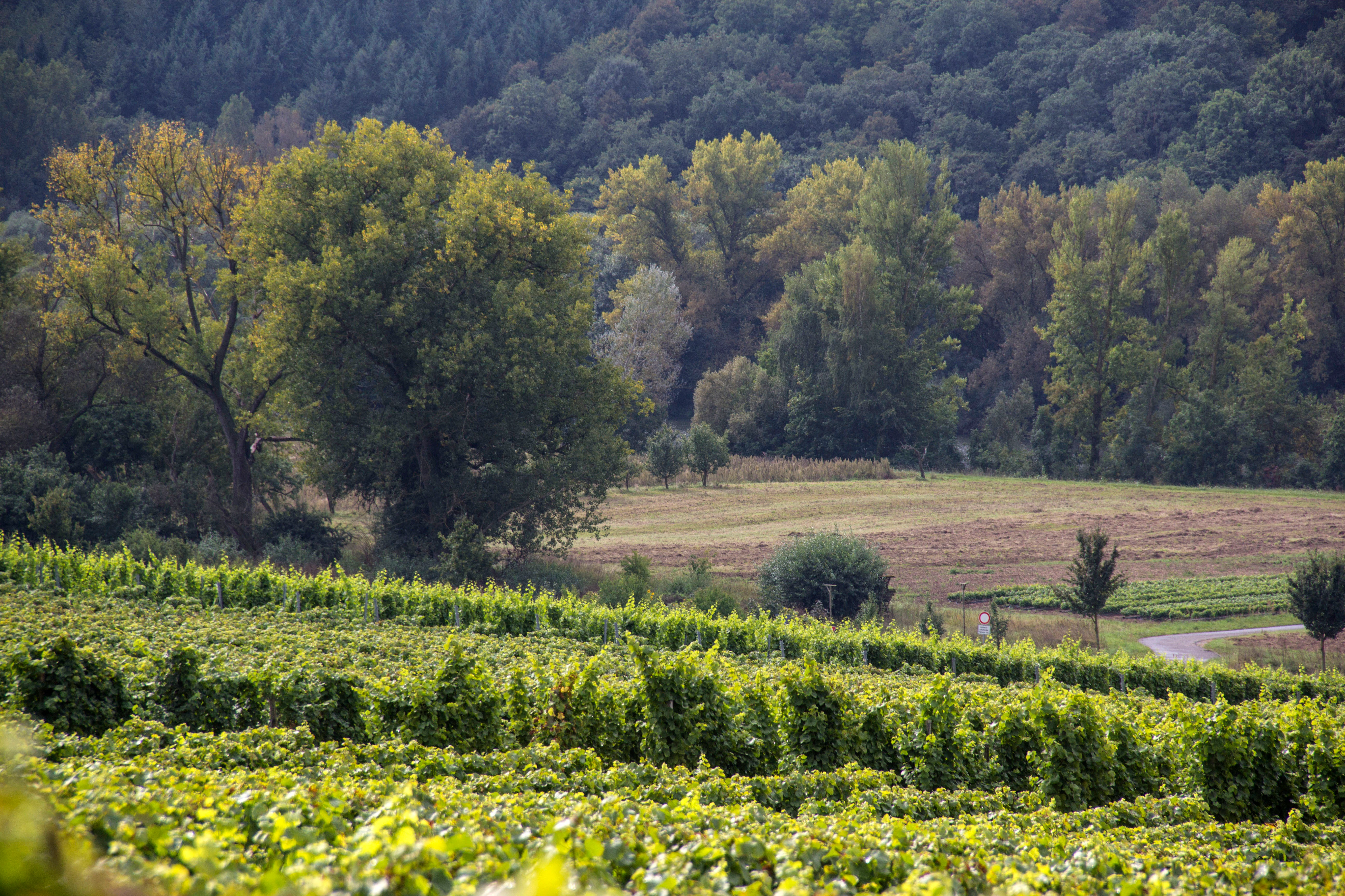
A landscape view featuring rows of grapevines in the foreground, sloping toward a middle ground of open fields, and a dense forest background.
Vineyards and riparian forest along the Main River near Sommerach.

Sandgrasheiden am Elgersheimer Hof history and protected-area timeline

The history of Sandgrasheiden am Elgersheimer Hof begins in 1986, when an earlier natural monument known as Flugsande bei Fahr, the drifting sands near the village of Fahr, was elevated to a formal protection status. This first step recognized the ecological value of the open sandy soils in the southern part of the Fahr village territory, an area that had probably retained its unusual dry grassland character because the loose sandy ground was unsuitable for intensive farming.

On 1 December 1999, the protection was extended and reorganized into the present nature reserve. The new designation brought together two adjacent but physically separate zones south of the road Am Sportplatz, creating the two-part structure that defines the reserve today. Since then, the area has been managed as part of the Natura 2000 ecological network and is listed under the identifier DE6027471, contributing to the broader Main valley conservation corridor between Schweinfurt and Dettelbach. A regional natural heritage inventory by Andreas Pampuch has helped document the importance of such small protected sites within the Landkreis Kitzingen.

Sandgrasheiden am Elgersheimer Hof landscape and geographic character

The landscape of Sandgrasheiden am Elgersheimer Hof is shaped by the unusual presence of loose, sandy soils in a region that is otherwise dominated by the agricultural and forested slopes of the Main valley in Lower Franconia. The two protected parcels sit in the southern part of the Fahr village territory, on gently undulating ground that lies between the settled farmland of the village and the meadows bordering the Main river. The western parcel opens out into this more agricultural transitional zone, while the eastern parcel is enclosed by woodland on its flanks.

This combination of open sand, dry grassland vegetation, wetter riverine meadows to the west, and forest to the east gives the reserve a distinctive mosaic character for such a small area. The exposed sandy ground is the central feature of the landscape and the reason it is called Sandgrasheiden, or sand grasslands. The soils are dry and free-draining, and they have historically supported open plant communities rather than closed forest, which is unusual in a region where woodland cover has been increasing.

Sandgrasheiden am Elgersheimer Hof ecosystems, habitats, and plant life

The ecological character of Sandgrasheiden am Elgersheimer Hof is dominated by its sand grassland vegetation, a relict habitat type that depends on ongoing open, dry conditions to survive. The loose sandy substrate prevents the build-up of richer soils, which in turn sustains a specialised community of plants, mosses, fungi, and lichens adapted to drought, heat, and low nutrient levels. Compared with the surrounding agricultural land and forest, the reserve therefore functions as a small island of uncommon, light-requiring biodiversity in the Main valley.

Because the sandy soils are easily disturbed, the habitat is also vulnerable. The presence of Jurinea cyanoides, a species listed as endangered across much of Europe, elevates the site's conservation significance well beyond its modest size. The combination of rare vascular plants, mosses, lichens, and fungi gives the reserve an unusually rich small-scale biodiversity profile for a habitat of this type, and reinforces the value of local protection to prevent the area from being overtaken by scrub or woodland succession.

Sandgrasheiden am Elgersheimer Hof wildlife and species highlights

Although the reserve is best known for its plant communities, the sand grassland and its surroundings also provide habitat for characteristic dry-ground invertebrates and the bird species associated with open sandy landscapes and the wider Main valley. The designation of the broader area DE6027471, which includes this reserve, as a bird protection area reflects the importance of these open and semi-open habitats for birds that depend on rough grassland, low scrub, and nearby farmland or water bodies.

The mosaic of dry sandy ground, meadow, and forest creates a variety of microhabitats within a very small footprint, supporting a mix of species typical of dry habitats alongside those associated with the wooded edges and the Main river corridor. While the site is not primarily a large mammal reserve, this habitat diversity contributes to the broader ecological network of the Main valley.

Sandgrasheiden am Elgersheimer Hof conservation status and protection priorities

From a conservation perspective, Sandgrasheiden am Elgersheimer Hof is significant as a surviving relict of a sand grassland habitat that has been heavily reduced across central Europe through agricultural intensification, afforestation, and urban development. Its formal protection as a nature reserve and its inclusion in the Natura 2000 network both as a Flora-Fauna-Habitat area and as part of a larger bird protection area underline its value at the European scale.

The conservation aim of the reserve is explicitly focused on maintaining the open sand conditions necessary for Jurinea cyanoides and the associated community of rare plants, mosses, lichens, and fungi. Management efforts are therefore directed at preventing the gradual encroachment of shrubs and trees, which would otherwise shade out the dry grassland community and undermine the ecological function of the site.

Sandgrasheiden am Elgersheimer Hof cultural meaning and human context

Sandgrasheiden am Elgersheimer Hof fits into a wider local context of small, ecologically valuable protected sites within the Landkreis Kitzingen in Lower Franconia. The reference to the historic farmstead Elgersheimer Hof, from which the reserve takes its name, reflects the long-standing pattern of small isolated farms and hamlets along the Main valley. The persistence of open sandy ground in an otherwise heavily farmed and forested landscape is itself tied to the historical difficulty of cultivating these soils, which left the area unsuitable for intensive arable use and helped preserve the unusual vegetation that modern conservation now seeks to protect.

Top sights and standout views in Sandgrasheiden am Elgersheimer Hof

Sandgrasheiden am Elgersheimer Hof stands out for the survival of open sand grassland habitat in an intensively used agricultural and forested region of the Main valley. The reserve's two-part structure, with a more open western parcel near river meadows and an eastern parcel enclosed by woodland, gives visitors a real sense of how this unusual habitat sits within its surrounding landscape. Its role as a refuge for Jurinea cyanoides and a relict community of specialised plants, mosses, lichens, and fungi gives it disproportionate conservation value relative to its size, and its integration into the larger Maintal zwischen Schweinfurt und Dettelbach Natura 2000 site connects it to one of the most important nature conservation corridors in Lower Franconia.

Best time to visit Sandgrasheiden am Elgersheimer Hof

The reserve is best experienced in the warmer half of the year, when the sand grassland vegetation is actively growing and the rare plants, mosses, and lichens are easiest to observe. Late spring and summer typically offer the most vivid display of flowering plants and the clearest view of how open the sandy ground remains between the surrounding forest and agricultural land. Early autumn can also be rewarding for observing fungi associated with the dry sandy soils and for appreciating the contrast between the open reserve and the surrounding wooded and farmed landscape of the Main valley.

Monthly climate preview

Measured long-term temperature ranges and monthly precipitation averages for Bavaria

Sandgrasheiden am Elgersheimer Hof Climate Normals and Annual Weather Pattern

Representative coordinate records show average temperatures ranging from negative sub-zero winter minimums to warm summer maximums alongside consistent daily precipitation. Reviewing the complete twelve-month climatology profile provides detailed insight into long-term thermal rhythms across this protected landscape.
Annual mean9 °C
-1 °C20 °C
Jan-1°
Feb
Mar
Apr
May13°
Jun17°
Jul20°
Aug19°
Sep15°
Oct
Nov
Dec
Warmest month
July

19.7 °C

Coolest month
January

-0.7 °C

Wettest month
July

2.4 mm/day

Driest month
April

1.3 mm/day

Park location guide

Geography guide, regional context, and park location map for Sandgrasheiden am Elgersheimer Hof

Sandgrasheiden am Elgersheimer Hof park geography, regions, and map view in Germany

Understand where Sandgrasheiden am Elgersheimer Hof sits in Germany through a broader geographic reading of the surrounding landscape, nearby location context, and its mapped position within the national park landscape.

How Sandgrasheiden am Elgersheimer Hof fits into Germany

Germany is a federal republic in Western and Central Europe with a population of over 83 million across sixteen constituent states. It is Europe's largest economy by nominal GDP and a major global exporter and importer. The capital is Berlin, and the country borders Denmark, Poland, Czech Republic, Austria, Switzerland, France, Luxembourg, Belgium, and the Netherlands.

Wider geography shaping Sandgrasheiden am Elgersheimer Hof in Germany

Germany is located in Western and Central Europe, spanning 357,022 km². It borders Denmark to the north, Poland and the Czech Republic to the east, Austria and Switzerland to the south, and France, Luxembourg, Belgium, and the Netherlands to the west. The country has coastlines on the Baltic Sea and North Sea to the north, with the Alps located in the southern region.

Map view of Sandgrasheiden am Elgersheimer Hof

Use this park location map to pinpoint Sandgrasheiden am Elgersheimer Hof in Germany, understand its exact geographic position, and read its mapped placement within the surrounding landscape more clearly.

Pigeon | © OpenStreetMap contributors

Location context for Sandgrasheiden am Elgersheimer Hof

Bavaria
Recorded earthquake history

Explore Historical Earthquake Records near Sandgrasheiden am Elgersheimer Hof

Review the recorded seismic history associated with the protected landscapes of Sandgrasheiden am Elgersheimer Hof. This catalogue provides valuable geographic context on nearby earthquake events, allowing for a clearer understanding of the seismic environment surrounding this rare Bavarian nature reserve.

Sandgrasheiden am Elgersheimer Hof Earthquake History

Catalogued events

4 events

Strongest magnitude

Magnitude 3.4

Most recent event

Jul 2, 2001

This history includes earthquakes recorded inside the park or within 50 km of its borders

Photographic reference for rare sand grassland habitats and protected terrain

Visualizing Sandgrasheiden am Elgersheimer Hof, Landscape Photos and Scenery

Visual records capture the rare sand grassland habitats, exposed sandy soils, and distinctive ecological mosaic of Sandgrasheiden am Elgersheimer Hof. Detailed park photography reveals the terrain, dry vegetation, and protected character of this Bavarian nature reserve.

A landscape view featuring rows of grapevines in the foreground, sloping toward a middle ground of open fields, and a dense forest background.

A metal information sign on a post in the foreground, with an open grassy field and forest in the background.

Park atlas

Compare regional nature reserves and connected conservation corridors across the Main valley.

Explore Parks Near Sandgrasheiden am Elgersheimer Hof and Surrounding Protected Landscapes

Discover other protected areas and regional nature reserves situated close to Sandgrasheiden am Elgersheimer Hof. Comparing these neighboring habitats provides a broader geographic view of the wider Lower Franconia conservation network.
A watercolor painting of a gentle landscape showing grassy plains, distant rolling hills, and patches of trees.
Nature reserveBayern
5.6 km away#1 closest

Southeast

Sandfluren bei Volkach, Schwarzach am Main und Sommerach: Protected Sand Habitats

Inland dune formations and xerothermic grasslands in Bayern

Located in the Main valley, this nature reserve is defined by its inland sand dunes and drift sand flats that provide a refuge for specialized flora and fauna. As a designated Geotop and Natura 2000 site, it offers a distinct study of arid habitats surviving within an agricultural landscape. Explore the geographic boundaries and terrain mosaic that make this protected area a noteworthy feature of the Lower Franconian environment.

Area
1.048 km²
Established
1989
IUCN
IV
Watercolor painting of a green forested landscape with soft rolling hills in the background.
Nature reserveBavaria
About 12 km away#2 closest

South

Naturwald Schwarzacher Tännig: Protected Oak Forest and Regional Landscape Context

Natural forest reserve in the Steigerwaldvorland of Bavaria

Naturwald Schwarzacher Tännig stands as a dedicated nature reserve in Bavaria, focused on the preservation of old-growth oak habitats. By removing this state forest area from active timber production, the reserve supports essential natural regeneration and structural biodiversity. The site functions as a key element within the regional ecological network of the Steigerwald foothills, illustrating the importance of small protected areas for maintaining diverse lowland forest habitats.

Area
0.095 km²
Established
2021
Relief
Upland
Scope
Terrestrial
A watercolor painting of a rolling landscape with scattered trees, grasslands, and soft rolling hills in the background, rendered in pale pastel tones.
Nature reserveUnterfranken
About 13 km away#3 closest

Southeast

Sande am Tannenbusch bei Kleinlangheim Nature Reserve: Protected Area and Atlas Overview

Geography of the Steigerwaldvorland sand landscape

Discover the ecological composition of Sande am Tannenbusch bei Kleinlangheim, a nature reserve in Unterfranken defined by its inland sand deposits and fragmented woodland footprint. This site is significant for its sand grassland mosaic, serving as a primary habitat for farmland birds and representing a specialized enclave within the broader Klosterforst region.

Area
0.382 km²
Established
1995
IUCN
IV
Relief
Lowland
A horizontal watercolor painting showing a soft, layered forest landscape with coniferous trees in the foreground and rolling mountains in the distance.
Nature reserveGermany
About 15 km away#4 closest

Northeast

Naturwaldreservat Riedholz: Protected Woodland and Floodplain Forest in Lower Franconia

Mapped natural forest reserves in the Steigerwaldvorland region

Naturwaldreservat Riedholz represents a pioneering municipal initiative in Bavaria to preserve lowland forest processes permanently. Located near Grettstadt and Schwebheim, this protected woodland preserves moisture-loving vegetation and relict oaks, acting as a vital ecological anchor within the agricultural landscape of the Schweinfurt Basin.

Area
0.11 km²
Established
1999
Relief
Lowland
Scope
Terrestrial
Watercolor painting showing rolling green hills, trees in the midground, and purple-tinted mountains in the background against a white backdrop.
Nature reservePrichsenstadt
About 16 km away#5 closest

East

Naturwald Krackentännig Nature Reserve: A Protected Forest Landscape in Northern Bavaria

Geography of the Steigerwaldvorland and Gänsseegraben valley floor

Situated near Prichsenstadt, Naturwald Krackentännig acts as a refuge for ash and alder trees that thrive in the moist soils of the Lower Franconian countryside. This nature reserve provides a critical example of undisturbed forest development, showcasing a specialized ecosystem within the rolling hills of the Steigerwaldvorland and a commitment to preserving small-scale woodland habitats.

Area
0.026 km²
Established
2021
Relief
Lowland
Scope
Terrestrial
A horizontal watercolor painting showing a soft, natural landscape with rolling hills in the background, a line of trees in the midground, and a meadow with light wildflowers in the foreground.
Nature reserveSchweinfurt
About 19 km away#6 closest

North

Saumain in der Stadt Schweinfurt Nature Reserve: Protected Main River Floodplain Geography

A vital riverine nature reserve in Schweinfurt, Bavaria

Spanning over 11 hectares within the city limits of Schweinfurt, this nature reserve protects an isolated, stable arm of the River Main. The area functions as a critical riparian habitat, featuring still water zones, emergent reeds, and hardwood floodplains that provide essential refuge in an urbanized region of Lower Franconia. Explore the geographic footprint of this protected site within the context of the greater Maintal landscape.

Area
0.116 km²
Established
1993
Relief
Lowland
Climate
Temperate
Watercolor painting of a forest landscape with a grassy clearing and distant hills, rendered in soft green and pink tones.
Nature reserveGermany
About 21 km away#7 closest

East

Naturwald Waldhaus: Geographic Mapping of an Ancient Beech Reserve in Steigerwald, Bavaria

Protected natural woodland and forest biodiversity in northern Germany.

Naturwald Waldhaus stands as a prime example of a protected forest in the Steigerwald, recognized for its exceptionally old beech stands and documented saproxylic beetle populations. This nature reserve provides essential ecological continuity within the Bamberg district, representing a rare, undisturbed woodland landscape that serves as a cornerstone for forest research in southern Germany.

Area
1.062 km²
Established
1978
Relief
Upland
Climate
Temperate
A watercolor illustration depicting a soft, rolling landscape of green hills, distant mountain silhouettes, and a winding stream.
Protected areaBavaria
About 22 km away#8 closest

Southeast

Naturwald Speckfeld: Protected Forest Reserve and Steigerwald Geographic Detail

Broadleaf woodland and gypsum ridge landscapes in Bavaria

Naturwald Speckfeld offers a look into unharvested forest dynamics within the Steigerwald mountains. This protected area stands out for its steep topography, historical castle ruins, and rare broadleaf woodland transitions, providing a critical reference point for natural forest conservation in the Lower Franconia region of Bavaria.

Area
0.195 km²
Established
1978
Relief
Upland
Climate
Temperate

Common questions about visiting, size, designation, and location context for Sandgrasheiden am Elgersheimer Hof

Sandgrasheiden am Elgersheimer Hof FAQs for park facts, access, geography, and protected area context

Find quick answers about Sandgrasheiden am Elgersheimer Hof, including protected-area facts, park geography, trail and visitor context, and how the park fits into its surrounding country and regional landscape.
MoriAtlas Explorer

Continue Your Protected Areas Search Across the Global Atlas

Deepen your exploration by continuing the structured search for national parks and protected areas worldwide. Utilize the comprehensive filtering capabilities to compare different conservation landscapes and refine your understanding of global park geography. Discover more about the distribution and characteristics of protected natural areas.

Global natural geography