Mori Atlas logo
Wildlife reserveSierra de Quila

Analyzing the mountain terrain, forested ridges, and hydrological features of this protected natural area

Sierra de Quila: A Comprehensive Geographic Atlas of a Protected Wildlife Reserve in Jalisco, Mexico

Sierra de Quila represents a vital protected landscape in western Jalisco, characterized by its rugged mountain range and high-elevation peaks reaching toward 2,540 meters. This wildlife reserve encompasses a diverse array of ecosystems, including pine and oak forests, cloud forest patches, and subtropical deciduous vegetation. By serving as a critical watershed divide, the area supports complex hydrological networks, such as the Salto de Santa Rosa waterfall, while providing a habitat for numerous plant and animal species.

mountain rangepine forestsoak foreststemperate forestcloud forestsubtropical deciduous forest

Sierra de Quila

Wildlife reserve

Park overview

Structured park overview, official facts, and landscape profile for Sierra de Quila

Sierra de Quila park facts, protected area profile, and essential visitor context

Review the core facts for Sierra de Quila, including designation, size, terrain, visitor scale, habitats, and operating context in one park-focused overview.

About Sierra de Quila

Sierra de Quila is a protected mountain range in the western part of the Mexican state of Jalisco, lying between the municipalities of Tecolotlán, Tenamaxtlan, Ameca, and San Martín Hidalgo. Though the area was designated as a protected natural area on August 4, 1982, the forested mountains themselves have long defined the geography and identity of this part of Jalisco, shaping drainage patterns, settlement, and local livelihoods. The protected area covers roughly 151.92 square kilometers, a substantial block of intact mountain terrain in a region otherwise heavily shaped by agriculture and ranching.

The mountain range sits in a transitional zone where temperate and subtropical vegetation meet. Pine forests dominate higher elevations, while oak woodlands and mixed pine-oak associations fill the slopes, and subtropical deciduous forest, mesophilic cloud forest patches, grasslands, and scrubland occupy lower and drier areas. This mosaic of forest types contributes directly to the area's broad biodiversity, with the national biodiversity information system documenting more than 715 species of plants and animals, including species listed under Mexican conservation risk categories.

Geographically, Sierra de Quila also functions as a significant hydrological landmark. It acts as a watershed divide, separating the Ameca River basin on the north side of the range from the Armería River basin on the south. Streams descending from the northern slopes converge into the Río Grande, eventually becoming the Ameca River, which forms part of the boundary between Jalisco and Nayarit. Beyond its ecological importance, Sierra de Quila is appreciated for its scenic landscape, including waterfall features such as the Salto de Santa Rosa and panoramic views from its highest peaks, making it a destination for visitors year-round from nearby municipalities.

Quick facts and research context for Sierra de Quila

Sierra de Quila is a federally recognized Area for Protection of Flora and Fauna located in western Jalisco, roughly 100 kilometers southwest of Guadalajara. The protected area covers approximately 152 square kilometers across the municipalities of Tecolotlán, Tenamaxtlan, Ameca, and San Martín Hidalgo, and was established on August 4, 1982.

The territory is dominated by temperate mountain terrain, with elevations that include Cerro del Huehuentón at around 2,540 meters above sea level. It functions as a major watershed divide between the Ameca River basin to the north and the Armería River basin to the south, and supports more than 715 documented species of plants and animals.

Protection and recognition

Documented management scope and official protected area records

Sierra de Quila Protection Status and Terrestrial Conservation Data

Sierra de Quila maintains a documented terrestrial protection scope within its regional conservation framework. Official records compile available management parameters and designation details for thorough geographical analysis.

Protection details

Protection scope
Terrestrial
Transboundary protection
No
Park context

Deeper park guide and search-rich context for Sierra de Quila

Sierra de Quila history, landscape, wildlife, and travel context

Explore Sierra de Quila through its history, landscape character, ecosystems, wildlife, conservation priorities, cultural context, and seasonal travel timing in a structured park guide built for atlas discovery and search intent.

Why Sierra de Quila stands out

Sierra de Quila is especially known for its extensive pine and oak mountain forests and its role as a biodiversity refuge in western Jalisco. The range harbors over 715 plant and animal species and contains recognized ecological value for species such as white-tailed deer and pumas. Equally important is the area's status as a watershed divide, separating the Ameca and Armería river basins and feeding streams and springs that supply nearby communities. Its protected status as an Area for Protection of Flora and Fauna since 1982 gives it a strong conservation profile within Jalisco's network of natural areas.
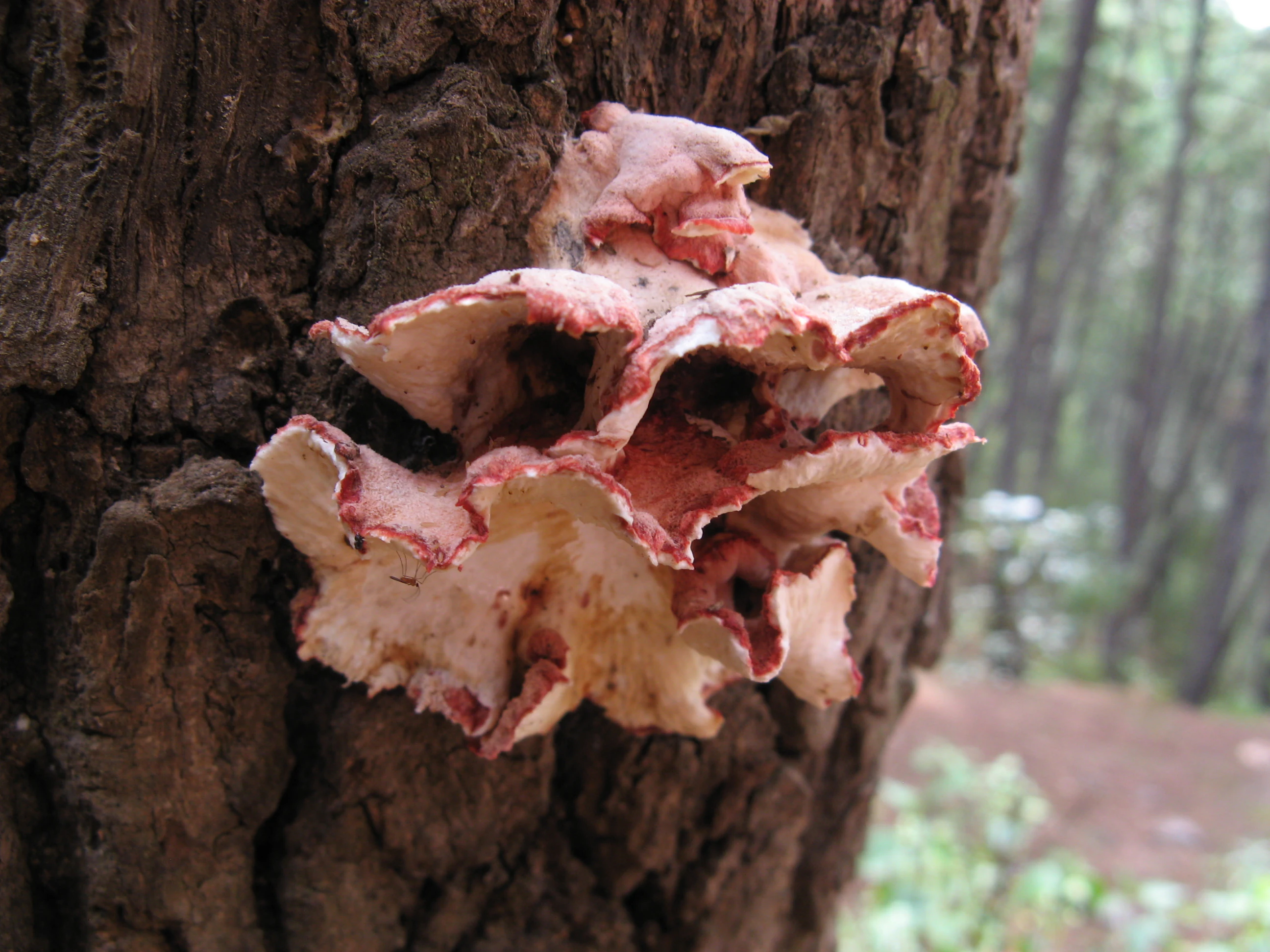
A cluster of pink, ruffled-edged shelf fungi growing directly out of the deep, dark, textured bark of a tree trunk in a forest.
Fruit bodies of the fungus Phlebia incarnata growing on a tree trunk in Sierra de Quila.

Sierra de Quila history and protected-area timeline

Sierra de Quila was formally recognized as a protected natural area by Mexican federal authorities on August 4, 1982. This designation reflected growing awareness of the ecological value of the mountain range, its forests, and its watershed functions in western Jalisco.

The protected category applied to the area is an Area for Protection of Flora and Fauna, a Mexican conservation designation focused on safeguarding ecosystems, species, and natural resources rather than purely scenic preservation. Since its establishment, the area has remained an important component of Jalisco's network of federally recognized natural protected areas, and it has continued to anchor regional conservation efforts for the pine and oak forests of the region.

Sierra de Quila landscape and geographic character

Sierra de Quila is a rugged mountain range in western Jalisco characterized by sharp elevation changes, forested ridges, and deeply incised canyons. The highest peak, Cerro del Huehuentón, rises to around 2,540 meters above sea level and serves as one of the most prominent summits in the state, offering expansive views of the surrounding region.

The terrain features steep-sided valleys and canyons filled with pine, oak, and mixed forests. Along the slopes and at lower elevations, the landscape transitions into subtropical deciduous forest, mesophilic cloud forest pockets, grasslands, and scrublands. Streams and springs feed distinctive hydrological features, including the Salto de Santa Rosa, a waterfall of more than 60 meters that drops through the forested canyons of the range.

The overall topographic character of Sierra de Quila gives it a strong visual identity. Sloping forested hills, high ridges, hidden springs, and dramatic waterfalls combine to form a classic temperate mountain landscape, contrasting with the agricultural lowlands that surround the range.

Sierra de Quila ecosystems, habitats, and plant life

The ecosystems of Sierra de Quila reflect the transition between temperate and subtropical climate zones in western Mexico. The dominant vegetation types are pine forest and oak forest, often occurring together as mixed pine-oak woodland, with additional communities including mesophilic cloud forest, subtropical deciduous forest, grasslands, and shrublands. This ecological diversity supports the protected area's broad species richness.

Climatic conditions across the range are predominantly temperate and humid, with annual mean temperatures typically between 12°C and 18°C and cooler conditions in higher elevations. Rainfall is concentrated in the months from June through September, with average annual precipitation ranging from around 700 to 1,000 millimeters depending on local conditions. These climate and vegetation patterns create a layered environment where montane, mesic, and drier habitats coexist in relatively close proximity.

Hydrologically, the range behaves as a major water source for the surrounding region. The mountains act as a divide between the Ameca and Armería river basins, and the springs and streams originating in Sierra de Quila supply several nearby communities. This combination of habitat diversity, climatic variability, and watershed function makes the area ecologically significant within Jalisco.

Sierra de Quila wildlife and species highlights

The protected area of Sierra de Quila supports a diverse fauna shaped by its mosaic of pine, oak, and subtropical forests. Documented wildlife includes white-tailed deer, pumas, wild boar, armadillos, and foxes, each occupying different niches within the mountain habitats. The presence of large predators such as pumas indicates that the area retains functional predator-prey dynamics and relatively intact habitat corridors.

Beyond these larger mammals, the range provides refuge for a wide variety of additional species, with biodiversity inventories recording more than 715 plant and animal species across the area. A portion of these are recognized under Mexican conservation risk categories, underscoring the area's importance for species that may be vulnerable elsewhere in the region.

The varied elevations, vegetation types, and water availability support a rich bird community and a broad spectrum of smaller vertebrates and invertebrates. This ecological richness reinforces the protected area's role as an important biological reservoir in western Jalisco.

Sierra de Quila conservation status and protection priorities

Sierra de Quila has been protected since August 4, 1982, under the Mexican federal category of Area for Protection of Flora and Fauna, a designation that prioritizes conservation of ecosystems, species, and watershed functions. Its protected status provides formal safeguards for its forests, wildlife, and hydrological resources, and integrates the area into Mexico's national system of protected natural areas.

The area's conservation significance is heightened by the fact that it contains more than 715 recorded species of plants and animals, including species listed under Mexico's official conservation risk categories. By preserving extensive tracts of pine and oak forest along with mesophilic and subtropical vegetation, Sierra de Quila helps maintain habitat connectivity and ecological processes in a region where land conversion for agriculture and ranching is widespread.

The range's role as a watershed divide between the Ameca and Armería river basins also gives it strong conservation importance beyond its biodiversity. Protecting the forested slopes helps regulate water flow, maintain water quality, and sustain springs and streams that supply nearby human communities, linking the area's ecological value directly to regional well-being.

Sierra de Quila cultural meaning and human context

The Sierra de Quila region reflects a long-standing relationship between human communities and the surrounding mountain landscape. The protected area overlaps with municipalities including Tecolotlán, Tenamaxtlan, Ameca, and San Martín Hidalgo, with the community of Quila el Grande providing the range with its name and serving as a regional reference point.

Local towns have historically depended on the mountains for water, forest products, and small-scale agriculture, and the streams and springs emanating from the range continue to supply several nearby populations. The presence of established visitor infrastructure in surrounding municipalities, including accommodations and camping options, reflects the integration of the Sierra into the cultural and economic life of western Jalisco.

Top sights and standout views in Sierra de Quila

Sierra de Quila stands out for the combination of its extensive pine and oak forests, its elevation reaching more than 2,500 meters at Cerro del Huehuentón, and its dramatic hydrological features such as the Salto de Santa Rosa waterfall. These landscape elements create a strong scenic and ecological profile within Jalisco.

Equally distinctive is the area's biodiversity, with more than 715 documented species and the presence of large mammals like white-tailed deer and pumas across varied habitats. Together with its role as a watershed divide between two major river basins and its protected status since 1982, these qualities make Sierra de Quila a high-value protected natural area in western Mexico.

Best time to visit Sierra de Quila

Sierra de Quila can be visited throughout the year, given its status as a year-round destination for visitors from nearby municipalities. The landscape changes character seasonally: the cooler months offer crisper conditions and clearer views from high points such as Cerro del Huehuentón, while the rainy season from June to September brings greener forests, fuller streams, and more powerful water flow at sites like the Salto de Santa Rosa waterfall.

Travelers who want lush vegetation, active wildlife behavior, and dramatic waterfall displays often find the wetter months rewarding, while those who prioritize drier trails, panoramic vistas, and milder walking conditions may prefer the cooler, drier parts of the year. Visitors typically access the area from Tecolotlán or Tenamaxtlan, which serve as gateways year-round.
Monthly climate preview

Track long-term monthly averages and temperature ranges across the protected landscape

Sierra de Quila Climate Normals, Annual Temperature and Precipitation Patterns

Representative coordinates record measured monthly temperature swings and seasonal precipitation rhythms across the protected terrain of Sierra de Quila. Examining the complete twelve-month climatology dataset reveals detailed variations in average minimum and maximum thresholds.
Annual mean20 °C
16 °C24 °C
Jan16°
Feb18°
Mar20°
Apr22°
May24°
Jun23°
Jul21°
Aug21°
Sep20°
Oct19°
Nov18°
Dec16°
Warmest month
May

24.1 °C

Coolest month
January

15.9 °C

Wettest month
July

6.9 mm/day

Driest month
April

0.1 mm/day

Park location guide

Geography guide, regional context, and park location map for Sierra de Quila

Sierra de Quila park geography, regions, and map view in Mexico

Understand where Sierra de Quila sits in Mexico through a broader geographic reading of the surrounding landscape, nearby location context, and its mapped position within the national park landscape.

How Sierra de Quila fits into Mexico

Mexico, officially the United Mexican States, is a country in North America spanning the Sierra Madre mountain ranges, coastal plains, and tropical regions. It borders the United States to the north, Guatemala and Belize to the southeast, and has coastlines along the Pacific Ocean, Gulf of Mexico, and Caribbean Sea. With a population exceeding 130 million, Mexico is home to one of the world's most significant concentrations of Indigenous languages alongside Spanish.

Wider geography shaping Sierra de Quila in Mexico

Mexico occupies a land area of 1,972,550 km2, making it the thirteenth-largest country in the world. The terrain is highly diverse, featuring the Sierra Madre Occidental and Sierra Madre Oriental mountain ranges, the Mexican Plateau, coastal lowlands along the Pacific and Gulf/Caribbean margins, and the Yucatan Peninsula. The country spans multiple climate zones from desert in the north to tropical rainforest in the south.

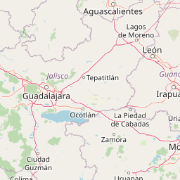
Map view of Sierra de Quila

Use this park location map to pinpoint Sierra de Quila in Mexico, understand its exact geographic position, and read its mapped placement within the surrounding landscape more clearly.

Pigeon | © OpenStreetMap contributors

Location context for Sierra de Quila

Jalisco

Mountain ridges, forest transitions, and watershed terrain through photographs

Sierra de Quila protected-landscape images from western Jalisco

Discover Sierra de Quila through imagery that shows the rugged mountain form and elevation changes of this protected western Jalisco landscape. Forest structure, high ridges, valleys, and water-shaped terrain provide visual reference for understanding how the reserve functions as a watershed divide.

A cluster of pink, ruffled-edged shelf fungi growing directly out of the deep, dark, textured bark of a tree trunk in a forest.

Park atlas

Compare regional mountain terrain and connected protected landscapes in western Jalisco

Other Protected Areas and Parks Near Sierra de Quila

Browse nearby national parks and protected areas to compare regional mountain terrain across western Jalisco. Extending the geographic review beyond Sierra de Quila reveals broader patterns in temperate forests and watershed ecosystems.
A watercolor painting showing a stylized, soft-focus landscape with rolling green hills and tall grasses against a pale background.
Protected areaJalisco
About 61 km away#1 closest

East

Laguna de Sayula Protected Area: Exploring the Salt Lake Basins and Geography of Jalisco

Ramsar wetland habitat within the Neo-Volcanic Axis

Laguna de Sayula spans a shallow tectonic depression in central-western Mexico, defined by its endorheic lake system and saline margins. This protected area provides a critical flyway for migratory birds while preserving a unique landscape of volcanic mountains, tropical deciduous forest, and ancestral salt harvesting sites. Trace the boundaries and natural features of this significant wetland in the southern region of Jalisco.

Area
168 km²
Relief
Lowland
Climate
Subtropical
Access
Access unknown
A horizontal watercolor painting depicting a soft-focus landscape with rolling green hills, patches of forest, and light golden hues representing meadows or dry terrain.
Biosphere reserveJalisco
About 67 km away#2 closest

Northeast

La Primavera Biosphere Reserve: Mapping Volcanic Landscapes and Protected Watersheds

Ecological geography and forest distribution in Jalisco, Mexico

Centering on the Sierra la Primavera volcanic complex, this biosphere reserve functions as an essential green corridor and water catchment zone. The terrain consists of a complex mosaic of vegetation types, including pine-oak forests and relict cloud forest patches across high-elevation ridges. Discover the structural role of these protected lands in moderating the climate and supporting biodiversity in the Guadalajara metropolitan region.

Area
305 km²
Established
2000
IUCN
VI
Relief
Mountain
State or regional parkJalisco
About 73 km away#3 closest

South

Bosque Mesófilo Nevado de Colima State Park: Atlas and Geographic Landscape Overview

Protected montane ecosystems of the Jalisco volcanic complex

Bosque Mesófilo Nevado de Colima State Park serves as a crucial protected area on the volcanic slopes of western Mexico. The territory captures an entire elevational gradient, shielding rare cloud forest stands from disturbance while providing a detailed study of volcanic topography, ranging from deep barrancas to high-altitude subalpine zacatonal grassland.

Area
72.14 km²
Established
2009
Relief
Mountain
Scope
Terrestrial
A watercolor painting showing a panoramic view of rolling hills and a light forest in a park setting.
Protected areaZapopan
About 82 km away#4 closest

Northeast

Bosque el Nixticuil Protected Area: Mapping the Urban Forest Landscape in Zapopan

Volcanic terrain and watershed protection in Jalisco

Bosque el Nixticuil represents a key case of community-led urban conservation. Covering roughly 1,860 hectares in the municipality of Zapopan, this area protects a rare old-growth oak and pine ecosystem from metropolitan development. The park encompasses diverse topographic features including shallow canyons and plains, serving as a vital ecological anchor for the surrounding Río Blanco basin.

Area
18.6 km²
Established
2008
Visitors
3.2M annual
Relief
Mixed relief
A horizontal watercolor illustration depicting rolling green hills and distant muted mountain ranges.
Nature reserveJalisco
About 90 km away#5 closest

Northeast

Barranca de Oblatos: Protected Canyon Nature Reserve and Geographical Landmark in Jalisco

Urban-adjacent nature reserve and protected river corridor

Barranca de Oblatos is a striking geological feature and nature reserve that anchors the biodiversity of the Guadalajara metropolitan region. Featuring a deep canyon system carved by the Rio Grande de Santiago, this protected area holds a complex mosaic of tropical deciduous forests and historical landmarks within its dramatic vertical walls. Explore the landscape context and natural boundaries that define this essential western Mexican wilderness area.

Area
11.37 km²
Established
1997
Relief
Highland
Climate
Subtropical
National parkJalisco
About 93 km away#6 closest

Southeast

Volcán Nevado de Colima National Park: National Park Protected Landscape Exploration

Mapping the geographic context and protected boundaries.

Delve into the protected landscape identity of Volcán Nevado de Colima National Park, a designated national park in Jalisco, Mexico. This detailed view focuses on its geographic context, providing insights into mapped park boundaries and the natural terrain that defines this significant protected area for comprehensive atlas discovery.

Area
65.55 km²
Established
1936
IUCN
II
Relief
Mountain
Wildlife reserveColima
About 100 km away#7 closest

Southeast

El Jabalí Flora and Fauna Protection Area: Volcanic Terrain and Forest Reserves in Colima

Mapping a diverse protected landscape in western Mexico

Located in the state of Colima, El Jabalí Flora and Fauna Protection Area presents a layered geography of volcanic slopes, pine-oak forests, and high-humidity cloud forest pockets. The area is defined by a series of permanent lagoons and streams that create a vital aquatic refuge. This entry provides a structured look at the physical boundaries and landscape characteristics of this essential Mexican wildlife sanctuary.

Area
51.79 km²
Established
2000
IUCN
VI
Relief
Mountain
Watercolor painting of a wide, calm lake surrounded by low, rolling hills and lush green vegetation under a soft, hazy sky.
Wildlife reserveJalisco
About 106 km away#8 closest

East

Lake Chapala Wildlife Reserve: A Geographic Exploration of Mexico's Largest Freshwater Basin

Highland volcanic landscapes and protected wetland boundaries in Jalisco

Lake Chapala functions as the central hydrological anchor of the Lerma-Santiago watershed. Situated on a high volcanic plateau, this protected wildlife reserve spans a broad valley floor surrounded by dramatic sierras. Gain detailed perspective on its unique endemic fauna, including rare fish species and migratory waterbirds, while navigating the mapped geography of its shoreline, islands, and basin-wide ecological footprint.

Area
1,100 km²
Established
2009
Relief
Mixed relief
Climate
Temperate

Common questions about visiting, size, designation, and location context for Sierra de Quila

Sierra de Quila FAQs for park facts, access, geography, and protected area context

Find quick answers about Sierra de Quila, including protected-area facts, park geography, trail and visitor context, and how the park fits into its surrounding country and regional landscape.
MoriAtlas Explorer

Continue Your Protected Areas Search Across the Global Atlas

Deepen your exploration by continuing the structured search for national parks and protected areas worldwide. Utilize the comprehensive filtering capabilities to compare different conservation landscapes and refine your understanding of global park geography. Discover more about the distribution and characteristics of protected natural areas.

Global natural geography