
Mori Atlas logo
Biosphere reserveLa Primavera Biosphere Reserve

Geographic analysis of the Sierra la Primavera volcanic complex and regional watershed

La Primavera Biosphere Reserve: Volcanic Terrain and Protected Landscapes in Jalisco, Mexico

(La Primavera Flora and Fauna Protection Area)

La Primavera Biosphere Reserve encompasses over 30,500 hectares of rugged volcanic terrain immediately west of Guadalajara, Jalisco. This protected landscape is defined by the Sierra la Primavera, an inactive volcanic complex featuring a large caldera, deep ravines, and elevation gradients ranging from 1,400 to 2,200 meters. The area serves as a critical hydrological regulator for the region, supporting diverse pine-oak and tropical deciduous forest ecosystems that provide vital environmental services to the surrounding urban population.

biosphere reservepine-oak forestvolcanic landscapeSierra la Primaveraflora and fauna protection areatropical deciduous forest
A stylized digital illustration of a mountainous landscape with a prominent cliff face, rolling green hills, and foreground trees silhouetted against a soft sunrise.

La Primavera Biosphere Reserve

Biosphere reserve

Park overview

Structured park overview, official facts, and landscape profile for La Primavera Biosphere Reserve

La Primavera Biosphere Reserve park facts, protected area profile, and essential visitor context

Review the core facts for La Primavera Biosphere Reserve, including designation, size, terrain, visitor scale, habitats, and operating context in one park-focused overview.

About La Primavera Biosphere Reserve

La Primavera Biosphere Reserve is a substantial protected natural area in western Mexico, anchored on the wooded slopes of Sierra la Primavera directly west of Guadalajara. Spanning about 30,500 hectares, it overlaps the municipalities of Tala, El Arenal, Zapopan, and Tlajomulco de Zúñiga, and forms one of the largest blocks of well-preserved forest in the central part of Jalisco.

The area lies at the biogeographic meeting point of the Nearctic and Neotropical regions, and spans two floristic provinces: the southern end of the Sierra Madre Occidental and the northern reaches of the Trans-Mexican Volcanic Belt. This positioning gives La Primavera a transitional character, blending northern pine-oak forests with more tropical vegetation types such as tropical deciduous forest and relict cloud forest fragments in sheltered stream valleys.

La Primavera holds layered designations that reflect its long history of protection. The first official safeguard came in 1934, when President Lázaro Cárdenas declared a forest protection zone around Guadalajara that encompassed the area. A broader public campaign and federal intervention led to its 1980 designation as a Forest Protection Zone and Wildlife Refuge by President José López Portillo, followed by a 2000 designation as a flora and fauna protection area and its 2006 recognition as a UNESCO Biosphere Reserve.

For the people of Guadalajara, La Primavera serves as a nearby natural escape, with a network of trails, educational camps, and recreational areas that draw weekend visitors from the city. Beyond recreation, the reserve plays a critical ecological role by filtering air, regulating water flow, and storing carbon, making it both a conservation site and a vital piece of urban infrastructure for the metropolitan region.

Quick facts and research context for La Primavera Biosphere Reserve

La Primavera is a 30,500 hectare protected natural area in Jalisco, Mexico, located immediately west of Guadalajara. It is administered under Mexico's National Commission of Natural Protected Areas as both a flora and fauna protection area (declared 2000) and a UNESCO Biosphere Reserve (designated 2006), after earlier protection decrees dating to 1980 and a first state-level protection in 1934.

The reserve sits across the municipalities of Tala, El Arenal, Zapopan, and Tlajomulco de Zúñiga, and is built around Sierra la Primavera, a geologically recent volcanic complex at the meeting point of the Sierra Madre Occidental and the Trans-Mexican Volcanic Belt. Its mosaics of pine, oak, and tropical deciduous forest, combined with cloud forest remnants in some stream valleys, give it unusually high biodiversity near one of Mexico's largest cities.

Protection and recognition

Documented protection history and official international designation details

La Primavera Biosphere Reserve Protection Status And UNESCO Recognition

Terrestrial conservation framing outlines the designation history and management scope established for La Primavera Biosphere Reserve in 2006. Official records incorporate documented UNESCO biosphere recognition alongside core administrative attributes for structured analysis.

International recognition

Protection details

Protection scope
Terrestrial
Designated year
2006
Transboundary protection
No
Core area
188.17 km²
Buffer area
118.19 km²
Park context

Deeper park guide and search-rich context for La Primavera Biosphere Reserve

La Primavera Biosphere Reserve history, landscape, wildlife, and travel context

Explore La Primavera Biosphere Reserve through its history, landscape character, ecosystems, wildlife, conservation priorities, cultural context, and seasonal travel timing in a structured park guide built for atlas discovery and search intent.

Why La Primavera Biosphere Reserve stands out

La Primavera is best known for being a young volcanic landscape cloaked in pine-oak forest, perched on the edge of a major Mexican metropolis. Its central feature, the Sierra la Primavera, is a relatively recent volcanic complex formed in eruptions between roughly 120,000 and 20,000 years ago, and its terrain rises from about 1,400 to 2,200 meters in elevation. The reserve is also recognized for its ecological service to Guadalajara: it captures an estimated 240 million cubic meters of rainwater annually, recharges surrounding aquifers, moderates the city's climate, and absorbs air pollutants. Together, these qualities have earned it a reputation as the green lung of the Guadalajara metropolitan area and a textbook example of an urban-adjacent biosphere reserve.
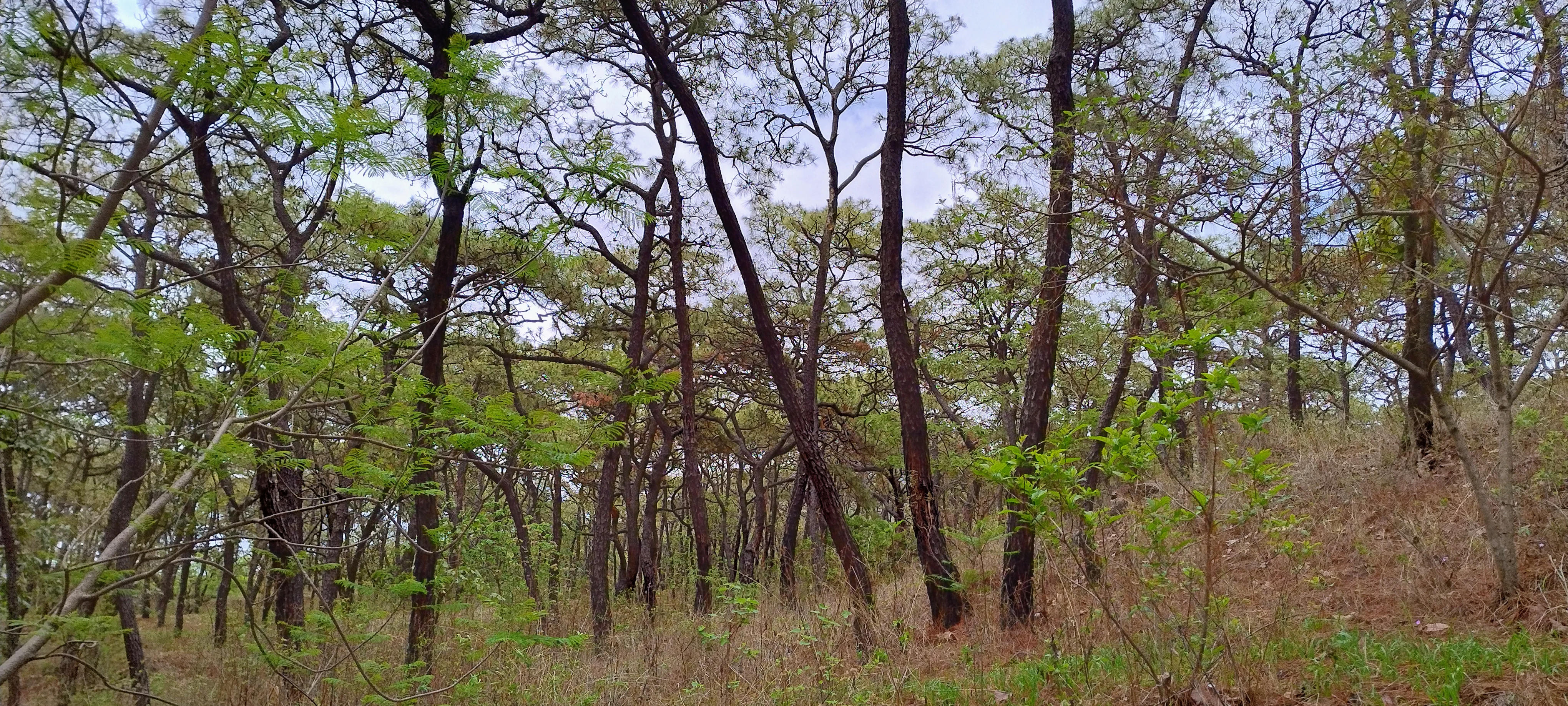
A mid-level view of a light pine,oak forest with thin tree trunks and green foliage against a pale sky.
A view of the pine,oak forest landscape within the La Primavera Biosphere Reserve.

La Primavera Biosphere Reserve history and protected-area timeline

The conservation history of La Primavera stretches back to the early twentieth century, and includes periods of protection, threat, and recovery. The first formal protection came in 1934, when President Lázaro Cárdenas declared a forest protection zone covering about 10,000 square kilometers around Guadalajara, an area that encompassed the Sierra la Primavera.

In the early 1960s, the Jalisco Forestry Commission, then under Governor Juan Gil Preciado, began coordinating the creation of a state park in La Primavera, a project that received federal support by 1964. However, in 1971 the State of Jalisco reclassified the forest as land of public utility and tourist use, opening the door to real estate development. Urbanization permits followed, with developments such as Pinar de la Venta, El Palomar, and Ciudad Bugambilias encroaching on the protected landscape.

A turning point came on 6 March 1980, when President José López Portillo issued a federal decree establishing the area as a Forest Protection Zone and Wildlife Refuge, restoring protection over roughly 30,500 hectares. Later that year, the state government moved to repeal earlier reclassifications that had designated parts of the forest for tourism or urban reserves, and acquired additional land to support environmental education and forestry research, including a 672-hectare transfer to the University of Guadalajara.

In 2000, the Mexican government redesignated La Primavera as a flora and fauna protection area, and in 2006 UNESCO added it to the World Network of Biosphere Reserves. These designations have not ended pressures on the reserve; a long-running geothermal installation by the national power company and recurrent wildfires in dry years have repeatedly tested the resilience of the forest and shaped ongoing conservation work.

La Primavera Biosphere Reserve landscape and geographic character

The landscape of La Primavera is shaped by the Sierra la Primavera, an inactive volcanic complex that forms the reserve's backbone. The Sierra is geologically young, built up by eruptions occurring between roughly 120,000 and 20,000 years ago, and contains within it a volcanic caldera of notable size. Its terrain is rugged and well dissected, with elevations that climb from about 1,400 meters to over 2,200 meters, producing sharp changes in forest composition along elevation gradients.

The reserve's volcanic origin has left a varied topography of ridges, ravines, and slopes, cut by streams and punctuated by small valleys. Approximately 20 permanent streams rise within the area, and numerous springs emerge from the volcanic substrate. Some drain north or east into the Río Grande de Santiago, while others flow west to form the headwaters of the Ameca River, making the reserve a critical water source for surrounding valleys and aquifers.

Climate conditions are tropical and subhumid, with warm temperatures year-round, an annual mean of about 21 degrees Celsius, and roughly 980 millimeters of rainfall each year. This combination of volcanic terrain, varied elevation, and reliable moisture supports a complex mosaic of vegetation types, from oak and pine forests on the higher slopes to tropical deciduous forest and gallery vegetation in the lower valleys.
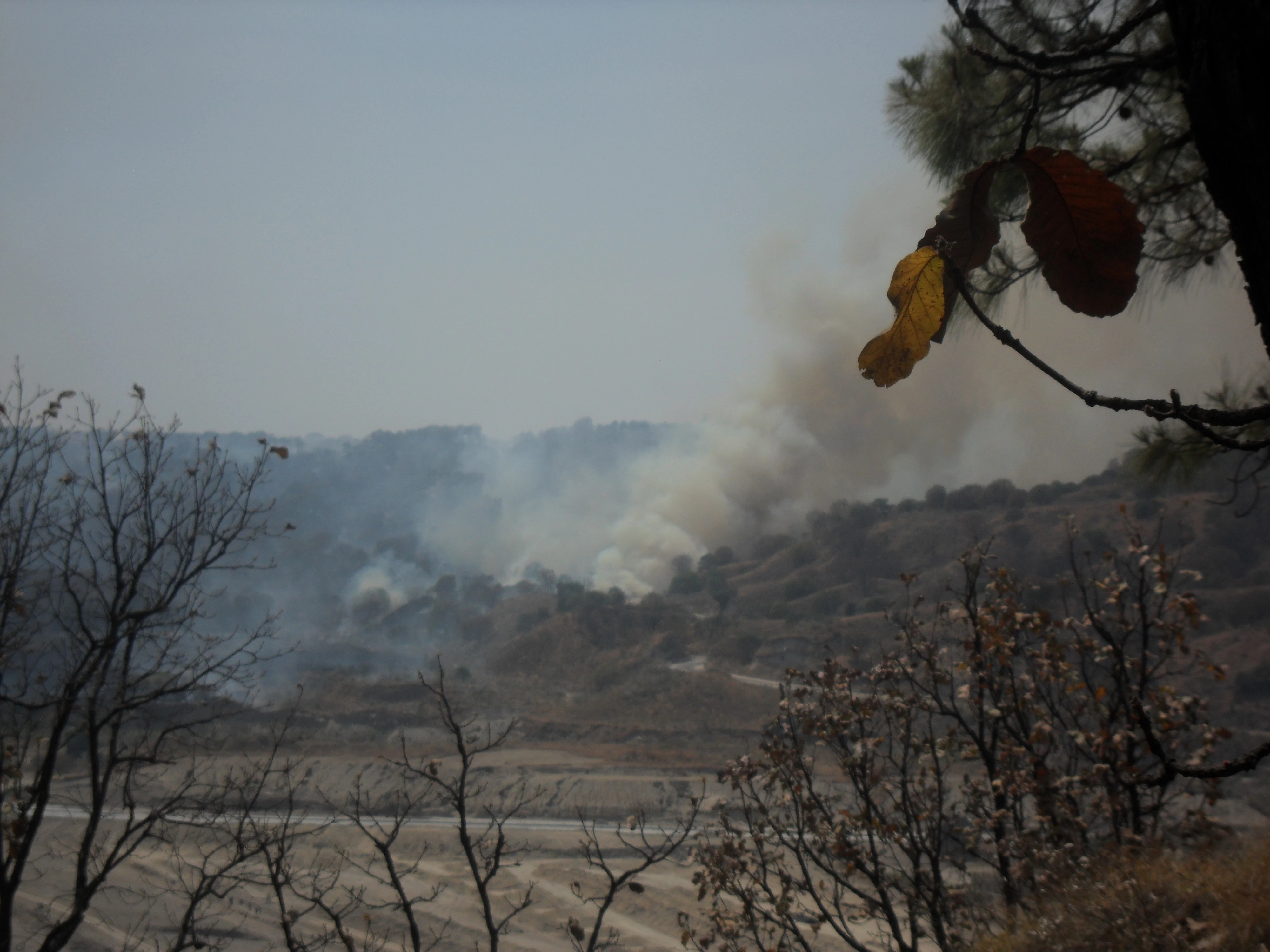
A view of a hillside in the La Primavera Biosphere Reserve covered in thick smoke from a forest fire, framed by foreground trees.
Smoke rising from a forest fire within the La Primavera Biosphere Reserve.

La Primavera Biosphere Reserve ecosystems, habitats, and plant life

Vegetation in La Primavera is organized into distinct communities that reflect altitude, slope, and moisture. The dominant forest is pine-oak woodland, which contains pure oak forest, pine forest, and several pine-oak and oak-pine mixtures. Tropical deciduous forest occupies lower and drier sites, while riparian, rupicolous, and ruderal communities grow along streams, on rocky outcrops, and in disturbed areas. With more than 740 plant species recorded in some inventories and over 1,000 according to national biodiversity data, the reserve has unusually high botanical richness for an area of its size.

A distinctive ecological feature is the presence of small patches of relict cloud forest in the wetter stream valleys of the western portion of the reserve, particularly along the headwaters of the Ameca River. These humid micro-refuges shelter trees such as Clethra rosei, Ficus insipida, Ilex dugesii, Morella cerifera, Persea hintonii, Prunus serotina subsp. capuli, Quercus magnoliifolia, Quercus confertifolia, and Salix taxifolia, and have even produced newly described endemic species, including a local poplar, Populus primaveralepensis.

The reserve lies at the overlap of two biogeographic regions, the Nearctic and Neotropical, and two floristic provinces, giving it a transitional ecological character shared by relatively few sites in Mexico. This dual identity is reinforced by the altitudinal zonation of its vegetation, with lowland oak associations giving way to higher pine-oak and pine forests on Cerro San Miguel and Cerro Planillas, the tallest peaks within the reserve.

La Primavera Biosphere Reserve wildlife and species highlights

La Primavera supports a remarkably diverse fauna for an area so close to a major urban center. Birdlife is particularly rich, with around 200 resident and migratory bird species recorded, representing roughly 135 species in some national counts. Characteristic species include lesser roadrunner, berylline hummingbird, russet-crowned motmot, black-throated magpie-jay, spotted wren, brown-backed solitaire, blue mockingbird, collared towhee, blue bunting, black-vented oriole, and rusty-crowned ground sparrow, many of which are emblematic of western Mexico's transitional forests.

The mammal community counts at least 29 species across roughly 25 genera and 14 families, with puma considered an indicator of habitat quality because of its wide-ranging needs. White-tailed deer, coyote, gray fox, bobcat, ringtail, common opossum, hooded skunk, long-tailed weasel, and jaguarundi are among the notable mammals documented, along with armadillo species. The jaguarundi is of particular conservation interest because of its threatened status under Mexican environmental standards.

Reptiles and amphibians also contribute to the reserve's biodiversity, with around 49 species recorded. Reptiles present include the Mexican black iguana, the Mexican rattlesnake Crotalus basiliscus, and the turtle Kinosternon integrum, while tarantulas in the genus Brachypelma represent some of the more charismatic invertebrate inhabitants of the forest.

La Primavera Biosphere Reserve conservation status and protection priorities

La Primavera's conservation role is closely tied to its position as an ecological buffer for the Guadalajara metropolitan area. Federal and state authorities have layered protections over the area across nearly a century, culminating in its 2000 designation as a flora and fauna protection area and its 2006 recognition as a UNESCO Biosphere Reserve. Its status under IUCN Category VI reflects an approach that allows controlled, sustainable use of natural resources alongside strict conservation objectives.

Beyond biodiversity, the reserve performs critical ecosystem services for urban Jalisco. Its forests capture an estimated 240 million cubic meters of rainwater per year, recharge aquifers in the Atemajac-Tesistán, Toluquilla, and Etzatlán-Ahualulco valleys, and indirectly support the Ameca Valley. They moderate Guadalajara's microclimate, improve air quality by absorbing carbon dioxide and other pollutants, reduce downstream flood risk, and safeguard water quality in regional rivers, a function that has become more important as the city continues to grow.

Despite this multi-tiered protection, the reserve faces persistent threats. Land tenure is fragmented between private owners, ejido communities, and state-held land, which complicates integrated management. Past and ongoing pressures include real estate development, geothermal drilling by the national power company, illegal logging, gravel extraction, contamination of streams such as Arroyo las Tortugas, overgrazing, and recurrent wildfires, including major events that have burned thousands of hectares and triggered environmental emergencies in the metropolitan area. Conservation planning thus combines biodiversity protection, fire prevention, water resource management, and careful regulation of public use.

La Primavera Biosphere Reserve cultural meaning and human context

La Primavera sits within a landscape that has supported human activity for at least a millennium and a half, with documented settlement in and around the forest dating back to around 350 CE. The arrival of Spanish settlers in the sixteenth century led to the founding of nearby Guadalajara and Tlajomulco, both of which relied on the forest's timber for construction and trade, beginning a long history of resource extraction that has shaped the region ever since.

In the late nineteenth and early twentieth centuries, the area was redefined by the Hacienda La Primavera, a tequila and resin-producing estate built by the Lancaster Jones family that gave the modern forest its name. By the 1960s, the hacienda's name had become commonly extended to the surrounding woodland and to the small community that grew around it, now part of the municipality of Zapopan. This blend of pre-Hispanic, colonial, hacienda, and modern urban history gives La Primavera a layered cultural geography that extends well beyond its ecological identity.

Top sights and standout views in La Primavera Biosphere Reserve

La Primavera stands out for combining volcanic geomorphology, transitional forest ecosystems, and proximity to one of Mexico's largest cities. Its youngest features, the slopes and caldera of Sierra la Primavera, give the reserve a distinctive profile of rugged ridges, deep ravines, and a mosaic of pine, oak, and tropical deciduous forest that changes quickly with altitude.

The reserve's biodiversity, with over 1,000 plant species, more than 130 bird species, and a mammal community that includes puma and jaguarundi, makes it a significant refuge within Jalisco. At the same time, its role in recharging aquifers and moderating Guadalajara's climate and air quality makes it a model of how a biosphere reserve can serve both conservation and urban sustainability at the same time.

Best time to visit La Primavera Biosphere Reserve

Because La Primavera has a warm subhumid tropical climate, conditions are broadly favorable throughout the year, but the dry season, roughly from late autumn through spring, brings the most stable weather and clearer skies. Dry months are also the best time for hiking and mountain biking on the reserve's network of trails, though they coincide with the period of greatest wildfire risk, so visitors should check current conditions before going.

The rainy season, generally running from late spring through early autumn, transforms the forest with greener vegetation, flowing streams, and more active birdlife, including migratory species. Cloud cover in higher elevations enhances the atmosphere of the relict cloud forest patches in the western stream valleys, but trails can become muddy and recreational cycling more challenging. For visitors interested in seeing the forest at its most lush, the rainy season offers the most dramatic landscapes, while those prioritizing accessibility often prefer the drier months.
Monthly climate preview

Long-term monthly temperature and precipitation averages for Jalisco

La Primavera Biosphere Reserve Climate Normals and Annual Temperature Rhythm

La Primavera Biosphere Reserve exhibits measured long-term temperature swings and distinct monthly precipitation variations across the representative coordinate. Examining the complete twelve-month record clarifies detailed climate normals and multi-season patterns across the protected terrain.
Annual mean20 °C
16 °C24 °C
Jan16°
Feb18°
Mar20°
Apr22°
May24°
Jun23°
Jul21°
Aug21°
Sep20°
Oct19°
Nov18°
Dec16°
Warmest month
May

24.1 °C

Coolest month
January

15.9 °C

Wettest month
July

6.9 mm/day

Driest month
April

0.1 mm/day

Park location guide

Geography guide, regional context, and park location map for La Primavera Biosphere Reserve

La Primavera Biosphere Reserve park geography, regions, and map view in Mexico

Understand where La Primavera Biosphere Reserve sits in Mexico through a broader geographic reading of the surrounding landscape, nearby location context, and its mapped position within the national park landscape.

How La Primavera Biosphere Reserve fits into Mexico

Mexico, officially the United Mexican States, is a country in North America spanning the Sierra Madre mountain ranges, coastal plains, and tropical regions. It borders the United States to the north, Guatemala and Belize to the southeast, and has coastlines along the Pacific Ocean, Gulf of Mexico, and Caribbean Sea. With a population exceeding 130 million, Mexico is home to one of the world's most significant concentrations of Indigenous languages alongside Spanish.

Wider geography shaping La Primavera Biosphere Reserve in Mexico

Mexico occupies a land area of 1,972,550 km2, making it the thirteenth-largest country in the world. The terrain is highly diverse, featuring the Sierra Madre Occidental and Sierra Madre Oriental mountain ranges, the Mexican Plateau, coastal lowlands along the Pacific and Gulf/Caribbean margins, and the Yucatan Peninsula. The country spans multiple climate zones from desert in the north to tropical rainforest in the south.

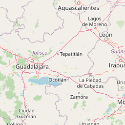
Map view of La Primavera Biosphere Reserve

Use this park location map to pinpoint La Primavera Biosphere Reserve in Mexico, understand its exact geographic position, and read its mapped placement within the surrounding landscape more clearly.

Pigeon | © OpenStreetMap contributors

Location context for La Primavera Biosphere Reserve

Jalisco

Visual exploration of rugged terrain, pine-oak forests, and protected habitats in western Mexico

La Primavera Biosphere Reserve Landscape Photos and Volcanic Scenery

Protected area photography reveals the rugged volcanic terrain, steep ridges, and dense pine-oak forests that define the Sierra la Primavera. Visual documentation helps observers understand the environmental character, forest transitions, and natural topography of this important biosphere reserve.

A mid-level view of a light pine,oak forest with thin tree trunks and green foliage against a pale sky.

A view from beneath the shade of a foreground tree looking across a golden grassy meadow toward distant rolling hills.

A view of a hillside in the La Primavera Biosphere Reserve covered in thick smoke from a forest fire, framed by foreground trees.

Park atlas

Compare adjacent volcanic terrain, pine-oak forests, and regional conservation landscapes

Explore Parks Near La Primavera Biosphere Reserve and Surrounding Protected Areas

Browse protected areas and national parks situated near La Primavera Biosphere Reserve to examine broader ecological corridors and regional volcanic geography. Comparing adjacent habitats deepens understanding of western Mexico conservation networks and regional watershed dynamics.
A watercolor painting showing a panoramic view of rolling hills and a light forest in a park setting.
Protected areaZapopan
About 14 km away#1 closest

Northeast

Bosque el Nixticuil Protected Area: Mapping the Urban Forest Landscape in Zapopan

Volcanic terrain and watershed protection in Jalisco

Bosque el Nixticuil represents a key case of community-led urban conservation. Covering roughly 1,860 hectares in the municipality of Zapopan, this area protects a rare old-growth oak and pine ecosystem from metropolitan development. The park encompasses diverse topographic features including shallow canyons and plains, serving as a vital ecological anchor for the surrounding Río Blanco basin.

Area
18.6 km²
Established
2008
Visitors
3.2M annual
Relief
Mixed relief
A horizontal watercolor illustration depicting rolling green hills and distant muted mountain ranges.
Nature reserveJalisco
About 26 km away#2 closest

East

Barranca de Oblatos: Protected Canyon Nature Reserve and Geographical Landmark in Jalisco

Urban-adjacent nature reserve and protected river corridor

Barranca de Oblatos is a striking geological feature and nature reserve that anchors the biodiversity of the Guadalajara metropolitan region. Featuring a deep canyon system carved by the Rio Grande de Santiago, this protected area holds a complex mosaic of tropical deciduous forests and historical landmarks within its dramatic vertical walls. Explore the landscape context and natural boundaries that define this essential western Mexican wilderness area.

Area
11.37 km²
Established
1997
Relief
Highland
Climate
Subtropical
A watercolor painting showing a stylized, soft-focus landscape with rolling green hills and tall grasses against a pale background.
Protected areaJalisco
About 65 km away#3 closest

South

Laguna de Sayula Protected Area: Exploring the Salt Lake Basins and Geography of Jalisco

Ramsar wetland habitat within the Neo-Volcanic Axis

Laguna de Sayula spans a shallow tectonic depression in central-western Mexico, defined by its endorheic lake system and saline margins. This protected area provides a critical flyway for migratory birds while preserving a unique landscape of volcanic mountains, tropical deciduous forest, and ancestral salt harvesting sites. Trace the boundaries and natural features of this significant wetland in the southern region of Jalisco.

Area
168 km²
Relief
Lowland
Climate
Subtropical
Access
Access unknown
Watercolor painting of a wide, calm lake surrounded by low, rolling hills and lush green vegetation under a soft, hazy sky.
Wildlife reserveJalisco
About 66 km away#4 closest

Southeast

Lake Chapala Wildlife Reserve: A Geographic Exploration of Mexico's Largest Freshwater Basin

Highland volcanic landscapes and protected wetland boundaries in Jalisco

Lake Chapala functions as the central hydrological anchor of the Lerma-Santiago watershed. Situated on a high volcanic plateau, this protected wildlife reserve spans a broad valley floor surrounded by dramatic sierras. Gain detailed perspective on its unique endemic fauna, including rare fish species and migratory waterbirds, while navigating the mapped geography of its shoreline, islands, and basin-wide ecological footprint.

Area
1,100 km²
Established
2009
Relief
Mixed relief
Climate
Temperate
Wildlife reserveJalisco
About 67 km away#5 closest

Southwest

Sierra de Quila: Protected Mountain Geography and Forested Wildlife Reserve in Western Jalisco

Mapped terrain, watershed boundaries, and high-altitude forest ecosystems

Sierra de Quila stands as a prominent protected mountain range in western Jalisco, offering a unique mosaic of pine, oak, and mesophilic cloud forests. This wildlife reserve serves as a essential natural anchor for regional biodiversity and watershed protection, with its rugged canyons and dramatic elevation changes providing a distinct geographical profile within the broader Mexican landscape.

Area
151.92 km²
Established
1982
Relief
Mountain
Climate
Temperate
State or regional parkJalisco
About 117 km away#6 closest

South

Bosque Mesófilo Nevado de Colima State Park: Atlas and Geographic Landscape Overview

Protected montane ecosystems of the Jalisco volcanic complex

Bosque Mesófilo Nevado de Colima State Park serves as a crucial protected area on the volcanic slopes of western Mexico. The territory captures an entire elevational gradient, shielding rare cloud forest stands from disturbance while providing a detailed study of volcanic topography, ranging from deep barrancas to high-altitude subalpine zacatonal grassland.

Area
72.14 km²
Established
2009
Relief
Mountain
Scope
Terrestrial
National parkJalisco
About 126 km away#7 closest

South

Volcán Nevado de Colima National Park: National Park Protected Landscape Exploration

Mapping the geographic context and protected boundaries.

Delve into the protected landscape identity of Volcán Nevado de Colima National Park, a designated national park in Jalisco, Mexico. This detailed view focuses on its geographic context, providing insights into mapped park boundaries and the natural terrain that defines this significant protected area for comprehensive atlas discovery.

Area
65.55 km²
Established
1936
IUCN
II
Relief
Mountain
Wildlife reserveColima
About 135 km away#8 closest

South

El Jabalí Flora and Fauna Protection Area: Volcanic Terrain and Forest Reserves in Colima

Mapping a diverse protected landscape in western Mexico

Located in the state of Colima, El Jabalí Flora and Fauna Protection Area presents a layered geography of volcanic slopes, pine-oak forests, and high-humidity cloud forest pockets. The area is defined by a series of permanent lagoons and streams that create a vital aquatic refuge. This entry provides a structured look at the physical boundaries and landscape characteristics of this essential Mexican wildlife sanctuary.

Area
51.79 km²
Established
2000
IUCN
VI
Relief
Mountain

Common questions about visiting, size, designation, and location context for La Primavera Biosphere Reserve

La Primavera Biosphere Reserve FAQs for park facts, access, geography, and protected area context

Find quick answers about La Primavera Biosphere Reserve, including protected-area facts, park geography, trail and visitor context, and how the park fits into its surrounding country and regional landscape.
MoriAtlas Explorer

Continue Your Protected Areas Search Across the Global Atlas

Deepen your exploration by continuing the structured search for national parks and protected areas worldwide. Utilize the comprehensive filtering capabilities to compare different conservation landscapes and refine your understanding of global park geography. Discover more about the distribution and characteristics of protected natural areas.

Global natural geography