Mori Atlas logo
Protected landscapeTrephina Gorge Nature Park

Mapping the arid ridges, riparian creek lines, and geological contrasts of central Australia.

Trephina Gorge Nature Park: A Deeply Carved Protected Landscape in the East MacDonnell Ranges

Trephina Gorge Nature Park preserves a vital section of the East MacDonnell Ranges where Trephina Creek cuts through ancient quartzite and sandstone ridges. This protected landscape reveals a stark geological history, with steep gorge walls framing sandy channels and waterholes that support unique arid zone bird species and hardy riparian vegetation. By tracing the park boundaries, visitors discover the structural complexity of these central Australian ranges and the ecological value of its sheltered valleys.

gorgemacDonnell RangesEast MacDonnell Rangescentral Australiaarid zonered rock

Trephina Gorge Nature Park

Protected landscape

Park overview

Structured park overview, official facts, and landscape profile for Trephina Gorge Nature Park

Trephina Gorge Nature Park park facts, protected area profile, and essential visitor context

Review the core facts for Trephina Gorge Nature Park, including designation, size, terrain, visitor scale, habitats, and operating context in one park-focused overview.

About Trephina Gorge Nature Park

Trephina Gorge Nature Park lies within the East MacDonnell Ranges, a long belt of rugged ridges that frames the central Australian landscape east of Alice Springs. The park protects a section of Trephina Creek where it has carved a deep, narrow gorge through hard quartzite and sandstone, producing the steep walls and sheltered creek pools that give the place its distinctive character.

Beyond the gorge itself, the park extends across a range of landforms typical of the East MacDonnell Ranges. Visitors move between shaded creek lines lined with river red gums, dry ridges dominated by mulga and spinifex, and exposed rocky slopes that catch the changing light of the desert sky. Walking tracks follow the creek and climb onto higher ground, offering different vantage points over the gorge system and the broader range country.

Ecologically, the park represents an important refuge for arid-zone species. The combination of rocky shelter, mature eucalypts, and reliable water along Trephina Creek supports a wider range of plants and animals than many of the surrounding plains. Birdwatchers are drawn to the area for species that favour this kind of rocky range habitat, and the creek corridor provides habitat for native mammals and reptiles adapted to the dry conditions.

Culturally, the gorge carries deep significance for its traditional Aboriginal owners. The park sits on land now held by the Atnerrperrke Aboriginal Land Trust, and the area is jointly managed in partnership with the Northern Territory government. This arrangement respects Aboriginal connection to country while keeping the reserve open for conservation and low-impact public enjoyment.

Protection and recognition

Explore the documented terrestrial conservation framework and official records for Trephina Gorge Nature Park.

Trephina Gorge Nature Park Protection Status and Management Scope

Trephina Gorge Nature Park maintains a documented terrestrial protection scope within its regional landscape. Conservation facts and recognition records provide structured reference data for professional analysis.

Protection details

Protection scope
Terrestrial
Transboundary protection
No
Park context

Deeper park guide and search-rich context for Trephina Gorge Nature Park

Trephina Gorge Nature Park history, landscape, wildlife, and travel context

Explore Trephina Gorge Nature Park through its history, landscape character, ecosystems, wildlife, conservation priorities, cultural context, and seasonal travel timing in a structured park guide built for atlas discovery and search intent.

Why Trephina Gorge Nature Park stands out

Trephina Gorge is best known for the dramatic quartzite gorge walls carved by Trephina Creek, the contrast between red rock and the white trunks of ghost gums, and its position as a culturally important site within the East MacDonnell Ranges. The park is also recognized for the high quality arid-zone birdwatching it supports, including species such as the grey-headed honeyeater and painted finch. Its accessibility from Alice Springs and its blend of scenic walking opportunities with strong Aboriginal land ownership make it distinctive among the nature parks along the MacDonnell Ranges corridor.
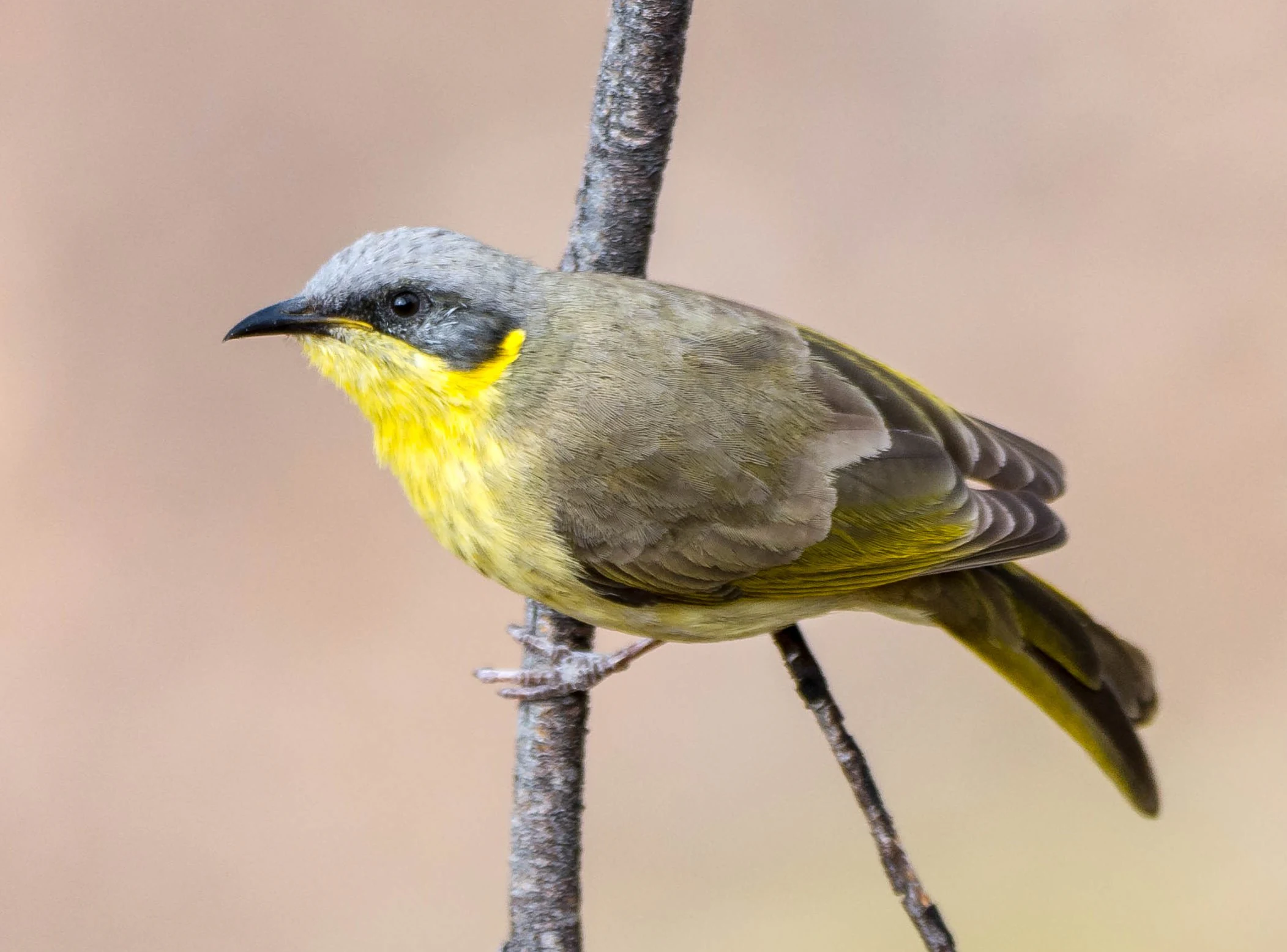
A small grey-headed honeyeater bird with olive-green wings and a bright yellow throat perched on a thin, vertical brown twig against a blurred light-brown background.
A grey-headed honeyeater perched on a branch within Trephina Gorge Nature Park.

Trephina Gorge Nature Park history and protected-area timeline

The land that now forms Trephina Gorge Nature Park was historically part of The Garden pastoral lease, which covered a large area east of Alice Springs. In the late nineteenth century, the gorge itself took its English name from Trephina Creek, itself believed to refer to Tryphina Benstead, the wife of William Benstead who managed Undoolya Station and later became the first licensee of the Stuart Arms Hotel in Alice Springs.

A formal change came on 12 August 1965, when a portion of the gorge was excised from the pastoral lease and gazetted as the Trephina Gorge Scenic Reserve. In 1978, the reserve was redesignated as Trephina Gorge Nature Park, recognising its value as a natural area rather than purely a scenic sight.

A more significant transformation occurred on 17 September 2008, when the title of the park land was transferred to the Atnerrperrke Aboriginal Land Trust, which holds the land on behalf of its traditional owners. The land was then leased back to the Northern Territory government for 99 years so that it could continue to operate as Trephina Gorge Nature Park, placing the reserve within a framework of Aboriginal ownership alongside long-term public conservation use.

Trephina Gorge Nature Park landscape and geographic character

The defining feature of Trephina Gorge Nature Park is the gorge itself, cut by Trephina Creek through the hard quartzite and sandstone of the East MacDonnell Ranges. The gorge is narrow and steep-walled, with rocky cliffs that rise on either side of a shaded creek line. Below the cliffs, the creek forms pools and sandy channels where river red gums and other water-dependent trees establish a green corridor in an otherwise arid setting.

Away from the creek, the terrain rises into the broader ridge country of the MacDonnell Ranges. Slopes carry sparse mulga woodland and spinifex-covered ground, with rocky outcrops and small side gorges breaking up the hills. The result is a landscape of strong contrasts: the deep shade of the gorge, the bright white trunks of ghost gums standing against red rock, and the wide, open range country stretching out toward the horizon.

The scenery changes character through the day as light shifts across the rocks and trees, and weather events that send water down Trephina Creek can reshape the creekbed, refill pools, and trigger rapid growth along the riparian strip.
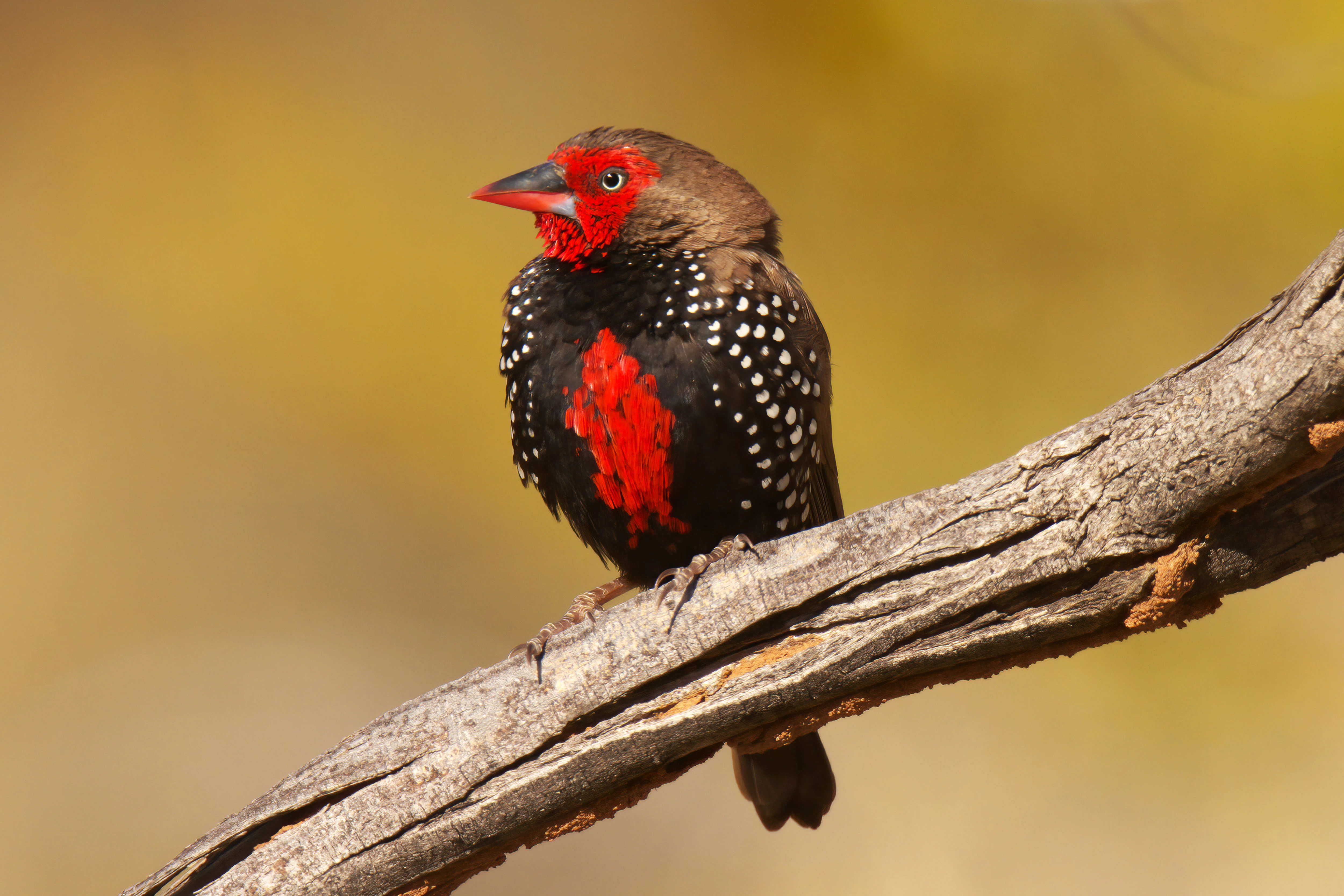
A close up view of a painted finch bird perched on a textured, weathered tree branch against a blurred golden background.
A painted finch perched on a branch within Trephina Gorge Nature Park.

Trephina Gorge Nature Park ecosystems, habitats, and plant life

Trephina Gorge Nature Park sits within a classic central Australian arid-zone ecosystem, where the combination of rocky refuge, mature trees, and water along the creek creates habitat for a richer community of plants and animals than much of the surrounding plain. The gorge acts as a cool, shaded microhabitat that supports both arid-adapted and water-dependent species.

Vegetation transitions clearly from the creekline to the ridges. Along Trephina Creek, river red gums dominate, with associated understorey plants that benefit from periodic flows. On the slopes and ridges above, mulga and other hardy acacias mingle with spinifex grasses and sparse shrubs, reflecting the broader pattern of the MacDonnell Ranges flora.

The mixture of habitats supports a varied insect and reptile community, which in turn underpins the presence of birds and small mammals. Birdlife is one of the most visible markers of ecological richness, with species that rely on rocky range habitat concentrated around the gorge and its margins.
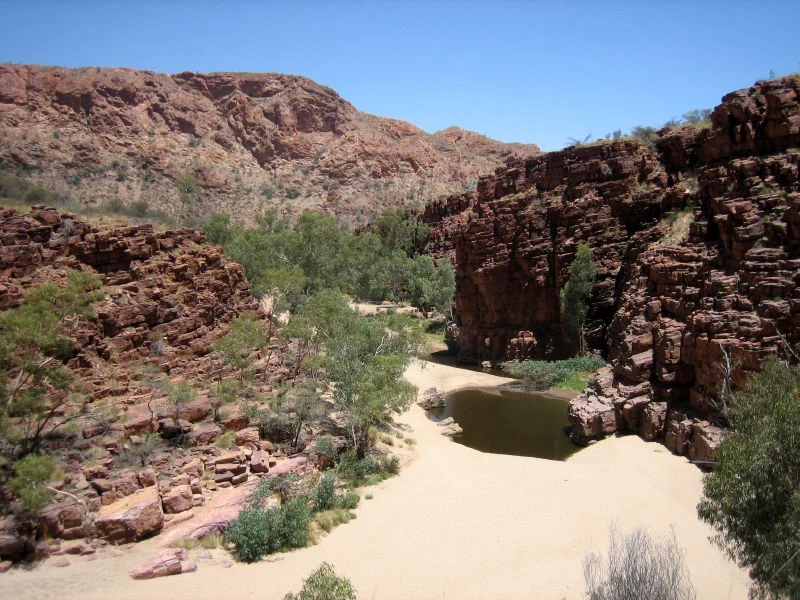
A wide view of a sandy creek bed and a small, dark, still waterhole surrounded by steep red rock cliffs and sparse trees under a clear blue sky at Trephina Gorge.
A permanent waterhole nestled in a sandy creek bed within the red rock formations of Trephina Gorge.

Trephina Gorge Nature Park wildlife and species highlights

The park is well known among visitors for its birdlife, which is characteristic of the East MacDonnell Ranges. The rocky range habitat and the presence of mature eucalypts along the creek attract species such as the grey-headed honeyeater and the painted finch, both of which are closely associated with arid range environments. Other honeyeaters, finches, and parrots typical of central Australia are also recorded in the area.

Mammal life includes native species adapted to rocky range country, with smallmarsupials and bats likely to use the shelter of the gorge and surrounding outcrops. Reptiles are well represented across the rocky slopes and creek flats, where goannas, dragons, and snakes form a normal part of the arid-zone fauna.

The relative density of life along Trephina Creek makes the park a productive site for observing arid-zone wildlife, especially for visitors interested in combining scenery with birdwatching.

Trephina Gorge Nature Park conservation status and protection priorities

Trephina Gorge Nature Park protects a representative section of the East MacDonnell Ranges within a long-term conservation framework. By conserving the gorge, its creek vegetation, and surrounding range habitat, the park safeguards a piece of central Australian arid-zone ecology that includes water-dependent plants, mature eucalypts, and the native fauna they support.

The park's long-term protection is reinforced by its governance arrangement. Following the 2008 transfer of title to the Atnerrperrke Aboriginal Land Trust, the land is held on trust for its traditional owners, with the Northern Territory government leasing it back for 99 years to continue operating the reserve. This model combines Aboriginal custodianship with ongoing public conservation management.

The refuge value of the gorge, particularly along Trephina Creek during drier periods, gives the park additional ecological importance as a place where water, shade, and rocky terrain intersect in an otherwise harsh landscape.

Trephina Gorge Nature Park cultural meaning and human context

The gorge is a place of long-standing cultural significance for its Aboriginal traditional owners. The land is held by the Atnerrperrke Aboriginal Land Trust, which represents the interests of the traditional owners who maintain ongoing connections to country in this part of the East MacDonnell Ranges.

The park's name also reflects Aboriginal heritage. In the Eastern Arrernte language, the gorge is known as Alherrkentye, preserving the Indigenous place name alongside the English title. The 2008 transfer of the park into Aboriginal ownership marked a formal recognition of this cultural connection, while the long-term lease to the Northern Territory government ensured continuity of public access and protected-area management.

The English name itself carries a different layer of regional history, being linked through Trephina Creek to early European settlers in the Alice Springs district during the late nineteenth century pastoral era.

Top sights and standout views in Trephina Gorge Nature Park

Trephina Gorge Nature Park stands out for the visual drama of its narrow quartzite gorge, its creek lined with river red gums and ghost gums, and its strong population of arid-zone birds, including the grey-headed honeyeater and painted finch.

It also stands out as a model of joint management in the Northern Territory, where land held by the Atnerrperrke Aboriginal Land Trust is leased back to government for long-term conservation use, combining Aboriginal custodianship with continued public enjoyment of the MacDonnell Ranges landscape.

Best time to visit Trephina Gorge Nature Park

The cooler months from late autumn through early spring are often the most comfortable time to explore Trephina Gorge, when daytime temperatures in the East MacDonnell Ranges are milder and the walking tracks along the gorge and ridges are easier to enjoy. Winter and early spring also tend to bring clearer skies and softer light on the gorge walls, which can enhance both scenery and photography.

Warmer months can still offer rewarding wildlife sightings, especially along the shaded creek line where birds concentrate around water and shade, but visitors should plan for higher temperatures and stronger sun exposure. Periods after rain can reshape the creekbed and bring fresh growth along the riparian strip, producing a noticeably greener and more active landscape.
Monthly climate preview

Long term temperature and precipitation records measured across twelve months

Trephina Gorge Nature Park Climate Normals and Annual Weather Patterns

Trephina Gorge Nature Park experiences a documented annual temperature rhythm ranging from cooler winter minimums to high summer maximums alongside low monthly precipitation averages. Examining the complete monthly climate profile reveals detailed long term weather data for this protected area.
Annual mean22 °C
12 °C30 °C
Jan30°
Feb28°
Mar26°
Apr22°
May16°
Jun13°
Jul12°
Aug15°
Sep20°
Oct24°
Nov27°
Dec29°
Warmest month
January

29.8 °C

Coolest month
July

12.4 °C

Wettest month
January

1.8 mm/day

Driest month
August

0.1 mm/day

Park location guide

Geography guide, regional context, and park location map for Trephina Gorge Nature Park

Trephina Gorge Nature Park park geography, regions, and map view in Australia

Understand where Trephina Gorge Nature Park sits in Australia through a broader geographic reading of the surrounding landscape, nearby location context, and its mapped position within the national park landscape.

How Trephina Gorge Nature Park fits into Australia

Australia is a constitutional monarchy and federal parliamentary democracy comprising six states and ten territories. With a population of nearly 28 million, it is one of the world's most urbanised countries, with most people concentrated on the eastern seaboard. The country has a high Human Development Index and is known for its cultural diversity, ancient Aboriginal heritage, and unique wildlife.

Wider geography shaping Trephina Gorge Nature Park in Australia

Australia occupies the entire Australian continent, the island of Tasmania, and numerous smaller islands. It is the world's flattest and driest inhabited continent, featuring vast deserts in the interior (the Outback), tropical rainforests along the eastern coast, and a coastline bordering the Indian and Pacific Oceans.

Map view of Trephina Gorge Nature Park

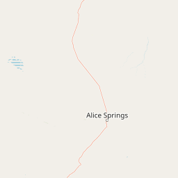
Use this park location map to pinpoint Trephina Gorge Nature Park in Australia, understand its exact geographic position, and read its mapped placement within the surrounding landscape more clearly.

Pigeon | © OpenStreetMap contributors

Location context for Trephina Gorge Nature Park

Northern Territory

Explore protected area imagery, quartzite gorge walls, and riparian habitats of the East MacDonnell Ranges.

Trephina Gorge Nature Park Photos and Scenery: Visualizing Central Australian Landscapes

Examine high-resolution park imagery to understand the rugged quartzite walls, shaded creek lines, and arid-zone habitats of Trephina Gorge Nature Park. Visual research helps decode the terrain, lighting variations, and native vegetation defining this central Australian conservation landscape.

A small grey-headed honeyeater bird with olive-green wings and a bright yellow throat perched on a thin, vertical brown twig against a blurred light-brown background.

Low-angle shot looking up at the pale white trunk and twisting branches of a ghost gum tree silhouetted against a deep blue sky.

A close up view of a painted finch bird perched on a textured, weathered tree branch against a blurred golden background.

A wide view of a sandy creek bed and a small, dark, still waterhole surrounded by steep red rock cliffs and sparse trees under a clear blue sky at Trephina Gorge.

Park atlas

Compare regional protected areas across the central Australian ranges corridor.

Explore Parks Near Trephina Gorge Nature Park and Surrounding Protected Landscapes

Browsing nearby national parks and protected areas helps reveal the broader geological and ecological patterns of the surrounding region. Comparing adjacent reserves expands geographical context beyond the individual gorge environment.
A wide watercolor illustration showing a winding river or creek bed flanked by green trees, with pink and red rocky hills in the background under a pale sky.
Nature reserveNorthern Territory
About 13 km away#1 closest

Southeast

N'Dhala Gorge Nature Park: Mapped Geography and Protected Cultural Heritage

Nature reserve located in the eastern MacDonnell Ranges

This nature reserve protects a vital valley corridor in the Northern Territory where sandstone ridges and sandy terrain meet. The park serves as a repository for approximately 6,000 ancient petroglyphs and sustains specialized arid plant species. Use this resource to understand the park's structural boundaries and its place within the broader geography of Central Australia.

Area
5.01 km²
Established
1962
IUCN
V
Relief
Mountain
Protected landscapeNorthern Territory
About 25 km away#2 closest

Southwest

Corroboree Rock Conservation Reserve: Geological and Cultural Protected Area in Central Australia

Mapped protected landscape within the East MacDonnell Ranges

Corroboree Rock Conservation Reserve features a striking dolomite rock formation tied to ancient Precambrian salt lake sediments. Located east of Alice Springs, the reserve provides a protected glimpse into central Australian arid range geography and holds profound cultural importance for the Eastern Arrernte Traditional Owners within the surrounding pastoral landscape.

Area
0.07 km²
Established
1962
IUCN
V
Visitors
15K annual
Protected areaNorthern Territory
About 34 km away#3 closest

East

Arltunga Historical Reserve: A Heritage Protected Area in Northern Territory Australia

Mapping nineteenth century mining ruins and arid terrain

Arltunga Historical Reserve offers a distinct window into the outback mining era through its well-preserved stone structures and desolate desert setting. This protected area within the Northern Territory highlights the intersection of European settlement history and the traditional cultural heritage of the Eastern Arrernte people.

Area
50 km²
Established
1975
Relief
Upland
Climate
Arid
National parkNorthern Territory
About 54 km away#4 closest

West

Tjoritja / West MacDonnell National Park: National Park Atlas and Protected Landscape

Explore the dramatic MacDonnell Ranges terrain and geography.

Delve into the protected geography of Tjoritja / West MacDonnell National Park, a significant national park in Australia's Northern Territory. This landscape features striking mountain formations, deep gorges like Standley Chasm and Glen Helen, and is intrinsically linked to the famous Larapinta Trail and the Arrernte people's cultural heritage. Understanding its mapped boundaries and regional context provides essential insight into this iconic Central Australian protected area.

Area
2,568.61 km²
Established
1992
IUCN
II
Relief
Mountain
A wide, panoramic watercolor painting showing a soft landscape with rolling hills in the background, green trees and bushes in the midground, and a pinkish path or river in the foreground.
Protected areaNorthern Territory
About 64 km away#5 closest

East

Ruby Gap Nature Park: Geography and Protected Wilderness in the Northern Territory

Gorge-carved arid landscapes and historical mining heritage

Ruby Gap Nature Park stands as a remote protected area in the heart of Australia's Northern Territory. Defined by the Hale River gorge, the terrain showcases dramatic cliff lines, expansive rocky flats, and rich geological sites that reveal a layered story of Indigenous heritage and 19th-century boom-and-bust mining history. Explore the park boundary and the surrounding East MacDonnell Ranges through this focused geographic overview.

Area
92.57 km²
Relief
Upland
Climate
Arid
Access
Remote access
Wildlife reserveNorthern Territory
About 70 km away#6 closest

Southwest

Kuyunba Conservation Reserve: Wildlife Protected Landscape in Central Australia

Mapped geography and rocky habitat near Alice Springs

Kuyunba Conservation Reserve represents a focused approach to habitat protection in the Northern Territory. The terrain is defined by its rocky hills and boulder-filled escarpments, offering critical shelter for wildlife in an arid, drought-adapted desert region. This site provides a clear view of how targeted land management supports specialized ecological niches in inland Australia.

Area
6.29 km²
Established
1970
IUCN
V
Relief
Upland
Watercolor painting of a soft, abstract landscape with a line of trees against rolling hills and light, hazy colors.
Nature reserveNorthern Territory
About 71 km away#7 closest

Southwest

Napwerte / Ewaninga Rock Carvings Conservation Reserve: Protected Desert Landscape Map

Cultural heritage and arid basin geography in the Northern Territory

Napwerte / Ewaninga Rock Carvings Conservation Reserve protects a unique desert site defined by its extensive collection of prehistoric Arrernte rock engravings. The landscape encompasses rocky outcrops, red sand dunes, and a seasonal claypan that captures rare rainfall, creating a significant intersection of archaeological history and arid-zone ecology in central Australia.

Area
0.06 km²
Established
1970
IUCN
V
Relief
Lowland
A horizontal watercolor painting showing stylized soft green, orange, and pale yellow hills under a white sky.
Nature reserveNorthern Territory
About 117 km away#8 closest

Southwest

Rainbow Valley Conservation Reserve: Geological Atlas and Protected Landscape Mapping

Examining the arid-zone terrain of Northern Territory, Australia.

The Rainbow Valley Conservation Reserve is a significant protected landscape known for its 350-million-year-old banded sandstone bluffs and diverse arid-zone habitats. This overview provides a focused look at the park's geological structure, claypan terrain, and its status as a vital site for Aboriginal heritage, offering a clear understanding of its place within the broader Northern Territory geographic context.

Area
24.83 km²
Established
1990
IUCN
V
Visitors
6.8K annual

Common questions about visiting, size, designation, and location context for Trephina Gorge Nature Park

Trephina Gorge Nature Park FAQs for park facts, access, geography, and protected area context

Find quick answers about Trephina Gorge Nature Park, including protected-area facts, park geography, trail and visitor context, and how the park fits into its surrounding country and regional landscape.
MoriAtlas Explorer

Continue Your Protected Areas Search Across the Global Atlas

Deepen your exploration by continuing the structured search for national parks and protected areas worldwide. Utilize the comprehensive filtering capabilities to compare different conservation landscapes and refine your understanding of global park geography. Discover more about the distribution and characteristics of protected natural areas.

Global natural geography