Why Upper Tweeddale National Scenic Area stands out
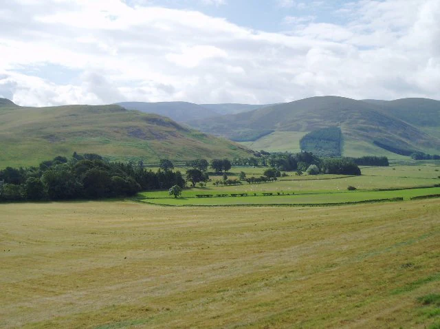
Upper Tweeddale is best known for the scenic upper valley of the River Tweed, where a narrow, steep-sided dale flanked by rounded hills creates the defining visual character of the area. The interplay between riverside meadows, mixed woodlands, parkland, pasture, rough grazing and arable farmland gives the valley floor a layered and changing appearance, while the tributary glens opening at the confluences of the Manor, Lyne and Holm Waters add depth and reveal higher summits at their heads. The area is also distinguished by the Tweedsmuir Hills, the largest mountain plateau in Scotland outside the Highlands, which provides an unusual upland element within an otherwise rolling southern Scottish landscape. Historic landmarks such as Neidpath Castle, Stobo Castle, Tinnis Castle and the hill fort at Dreva Craig further define the cultural profile of the area, embedding centuries of human settlement into a scenic valley setting.
Upper Tweeddale National Scenic Area history and protected-area timeline
The history of Upper Tweeddale National Scenic Area is closely tied to the broader development of landscape protection policy in Scotland in the twentieth century. Following the Second World War, a committee chaired by Sir Douglas Ramsay was established to review preservation of the Scottish landscape. Its 1945 report proposed that five areas of outstanding scenery should receive formal protection, and these were subsequently designated as national park direction areas, giving central government the power to review planning decisions taken by local authorities within them.
Landscape protection policy was reviewed again in 1978, and the report from that review identified additional areas, including the upper Tweed valley, as worthy of protection for their scenic qualities. As a result, in 1981 the original direction areas were replaced by the national scenic area designation, and Upper Tweeddale was among the new NSAs created under that framework. The defined boundaries of the area date back to the 1978 review and have remained unchanged through subsequent redesignations, including a further redesignation under new legislation in 2010.
Although the NSA carries weight in landscape protection terms, it does not have its own dedicated management authority. Local authorities, in this case Scottish Borders Council, are responsible for the planning regime that applies within it. Among Scotland's NSAs, only the three areas within Dumfries and Galloway currently have formal management strategies, leaving Upper Tweeddale protected primarily through the planning process and overlapping conservation designations rather than a dedicated management plan.
Upper Tweeddale National Scenic Area landscape and geographic character
The landscape of Upper Tweeddale is dominated by the upper valley of the River Tweed, where the river runs through a narrow, steep-sided valley flanked by rounded hills of considerable stature. This confined valley setting provides the area with a strong sense of enclosure, broken periodically where tributary rivers join the Tweed and the floor widens to reveal longer views into side glens and toward higher summits at their heads. The celebrated defile at Neidpath, where the river narrows between Caedmuir and the Meldons beneath the cliffs and castle, is one of the valley's most distinctive features.
Above and around the valley, the Tweedsmuir Hills form a substantial plateau landscape, notable as the largest area of mountain plateau in Scotland outside the Highlands. This upland terrain gives the NSA a stronger vertical scale and a wilder character than is typical of many southern Scottish landscapes, contrasting with the gentler rolling country that makes up the rest of the designated area.
The valley floor carries its own distinct landscape geography, characterized by a mosaic of riverside meadows, parkland, pasture, arable fields and rough grazing on the hill margins. Woodlands appear throughout in varied forms, including shelterbelt plantations, hedgerow trees, mixed deciduous stands and coniferous plantations. These woodland and farmland patterns interweave along the river and its tributaries, creating the layered scenery that the original 1978 report described as giving the dale its visual richness.
Upper Tweeddale National Scenic Area ecosystems, habitats, and plant life
Ecologically, Upper Tweeddale combines a productive river system with upland habitats and a patchwork of woodland, farmland and rough grazing. The River Tweed and its tributaries, including the Manor Water and Holm Water, traverse a geologically mixed catchment that supports a particularly diverse freshwater ecology. This ecological richness is one of the foundations of the area's broader conservation importance, and the river system carries multiple overlapping designations that reflect both its ecological value and its scenic role within the NSA.
The Tweedsmuir Hills, designated as a Site of Special Scientific Interest, add a distinctive upland ecological character to the NSA. As the largest mountain plateau in Scotland outwith the Highlands, they support nationally important populations of breeding birds and notable assemblages of mosses, liverworts and arctic-alpine plants. Vegetation patterns on the plateau and along the valley margins reflect the transition between lowland southern Scotland and genuinely upland conditions, which contributes to the area's ecological variety.
The designed landscapes around Barns Tower, Stobo Castle and Dawyck Botanic Garden are also recognized in the Inventory of Gardens and Designed Landscapes in Scotland. These areas add a managed ecological dimension to the NSA, combining native woodland, exotic plantings and ornamental grounds within the wider countryside setting.
Upper Tweeddale National Scenic Area wildlife and species highlights
The wildlife profile of Upper Tweeddale is shaped most prominently by the river system running through its heart. The River Tweed and its tributaries, including the Manor Water and Holm Water, support important populations of Atlantic salmon, brook lamprey, European river lamprey and sea lamprey, alongside European otter. These species underpin the designation of the river as a Special Area of Conservation, and the mixed geology of the catchment is credited with supporting a particularly diverse freshwater fauna within an otherwise relatively small river system.
In the uplands, the Tweedsmuir Hills SSSI hosts nationally important breeding bird populations and supports distinctive plant communities of mosses, liverworts and arctic-alpine species. The combination of these upland breeding bird populations with freshwater species along the Tweed gives the NSA a diverse wildlife character that spans riverine, valley and plateau habitats.
The varied mosaic of woodland, farmland, parkland and rough grazing across the valley floor adds further habitat diversity, supporting the more generalist wildlife typical of southern Scottish countryside, while managed grounds such as Sterbo Castle and Dawyck Botanic Garden contribute additional botanical and habitat interest within the broader protected landscape.
Upper Tweeddale National Scenic Area conservation status and protection priorities
Conservation in Upper Tweeddale operates through a layered system of overlapping designations. The national scenic area itself is primarily a landscape protection tool, applied through the planning process to safeguard the area from inappropriate development. NatureScot acts as the responsible body for the NSA designation.
Alongside the NSA, the River Tweed system, including tributaries such as the Manor Water and Holm Water, is protected as a Special Area of Conservation for its populations of Atlantic salmon, brook lamprey, river lamprey, sea lamprey and European otter. The river also carries Site of Special Scientific Interest status, reflecting both its ecological and scenic importance. A second SSSI within the NSA, the Tweedsmuir Hills, recognizes the upland plateau as one of the most ecologically distinctive areas in southern Scotland outwith the Highlands.
The cultural landscape also receives recognition. Grounds surrounding Barns Tower and Stobo Castle, together with Dawyck Botanic Garden, are listed in the Inventory of Gardens and Designed Landscapes in Scotland. Together, these overlapping designations give Upper Tweeddale a multi-layered conservation framework that protects its scenery, freshwater ecology, upland habitats and designed landscapes in combination.
Upper Tweeddale National Scenic Area cultural meaning and human context
Upper Tweeddale carries a strong cultural and historical dimension that complements its scenic and ecological value. The dale is marked by castles, towers, mansions, kirks and prosperous farmhouses, and the surrounding hills retain numerous remains of ancient occupation. Among the most prominent historic features are Neidpath Castle, which guards the defile above the river; Stobo Castle and its grounds further upstream; Tinnis Castle; and Barns Tower. The hill fort at Dreva Craig is another notable cultural feature, reflecting strategic and defensive use of the landscape over many centuries.
The area is also traversed by the John Buchan Way, a 22-kilometre walking route linking Broughton and Peebles, which has become an established cultural and recreational thread through the NSA. The combination of historic estates, ancient hill forts, designed gardens and long-established communities gives the area a layered cultural identity rooted in both the natural valley setting and the human history of the Scottish Borders.
Top sights and standout views in Upper Tweeddale National Scenic Area
Upper Tweeddale stands out for the way it concentrates exceptional scenery into a relatively compact southern Scottish valley, combining the narrow, steep-sided upper Tweed with the broad plateau of the Tweedsmuir Hills. The river and its tributary glens provide a continuous thread of scenic variety, while the plateau gives the area a scale and wildness rarely encountered in the Borders.
Its conservation layering is also a defining feature. A single NSA designation sits alongside Special Area of Conservation and SSSI protection for the river, a separate upland SSSI for the Tweedsmuir Hills, and Inventory of Gardens and Designed Landscapes recognition for designed grounds around Stobo, Barns Tower and Dawyck Botanic Garden. The result is a landscape whose scenic, ecological and cultural values are all formally recognized in combination.
Best time to visit Upper Tweeddale National Scenic Area
Upper Tweeddale's scenery shifts meaningfully with the seasons, reflecting both its lowland valley character and its upland plateau setting. Spring and early summer bring fresh greens to the valley woodlands, pasture and riverside meadows, while the tributary glens and the Tweedsmuir Hills plateau are most accessible on foot in these drier, longer days. Summer remains a popular period for walking routes such as the John Buchan Way, when the valley floor is at its most vivid and the higher ground is relatively approachable.
Autumn highlights the mixed woodlands along the river and its tributaries, and the broader valley scenery takes on warmer tones that complement the historic estates and castle settings. Winter can bring a quieter, more austere character, with the bare hills and steely river emphasizing the contained, dramatic shape of the valley. For birdwatchers and those interested in upland botany, the Tweedsmuir Hills plateau is likely to be most rewarding in late spring and summer when breeding birds and arctic-alpine plants are active.