Mori Atlas logo
Natural monumentVehlovické opuky

A stratified landscape of Cretaceous fossils, historical underground quarries, and bat wintering grounds.

Vehlovické opuky Natural Monument and Geological Heritage Site in Středočeský kraj

(Přírodní památka Vehlovické opuky)

Located in the Středočeský kraj region of the Czech Republic, Vehlovické opuky represents a significant protected area defined by its stratigraphic and paleontological wealth. The site preserves an intricate network of historical underground galleries carved into the Jizera Formation, offering a rare look at traditional stone extraction techniques. Beyond its geological importance as a fossil-rich Cretaceous site, the monument provides a critical underground refuge for various bat species during their hibernation cycle.

geological monumentCretaceous fossilsopuka quarriesunderground galleriesbat refugeJizera Formation

Vehlovické opuky

Natural monument

Park overview

Structured park overview, official facts, and landscape profile for Vehlovické opuky

Vehlovické opuky park facts, protected area profile, and essential visitor context

Review the core facts for Vehlovické opuky, including designation, size, terrain, visitor scale, habitats, and operating context in one park-focused overview.

About Vehlovické opuky

Vehlovické opuky is a small but unusually content-rich protected area in the Mělník District of Central Bohemia, focused on the geological and ecological legacy of historical opuka quarrying. Although the site covers only about 0.94 hectares, it concentrates a remarkable amount of scientific and historical material into a single locality near the town of Mělník.

The protected subject is the network of underground galleries dug during 19th and early 20th century extraction of opuka, a fine-grained Cretaceous sedimentary rock widely used in Central Bohemia for building stone, tiles, and troughs. Two distinct opuka horizons were worked at Vehlovice: a lower horizon and an upper, characteristically yellowish bed nicknamed žloutek. The yellowish horizon is the most fossiliferous and was the focus of underground working, yielding abundant fossils of fish, crustaceans, and large bivalves.

Stratigraphically, the site belongs to the Jizera Formation of the Bohemian Cretaceous Basin, an important regional reference sequence for Upper Cretaceous marine sediments. This makes Vehlovické opuky not only a fossil locality but also a teaching example of Bohemian Cretaceous stratigraphy, as the quarry faces and gallery walls preserve a clear section through the sedimentary layers.

In addition to its geological value, the monument protects the underground workings as a historically rare example of underground opuka extraction technique. Once mining ceased, the galleries found a second biological role: they now shelter colonies of bats and horseshoe bats during winter, including the lesser horseshoe bat (Rhinolophus hipposideros). The combination of geological, paleontological, mining-historical, and chiropterological values is what gives the site its distinct protected-area identity.

Quick facts and research context for Vehlovické opuky

Vehlovické opuky is a natural monument (IUCN Category III) covering roughly 0.94 hectares in the Mělník District of the Central Bohemian Region. It was formally protected on 1 January 2002 and is administered by the Central Bohemian Regional Authority.

The site protects underground galleries created by historical opuka mining, fossils from the Upper Cretaceous Jizera Formation, a documented example of rare underground extraction technique, and winter bat roosts. The locality lies near the Polabská dráha railway corridor, whose construction in the 19th century stimulated the original opening of the larger Vehlovice quarries.

Protection and recognition

Terrestrial protection status, management scope, and recognition data

Vehlovické opuky Protection Status and Conservation Framework

Vehlovické opuky maintains a documented terrestrial protection status within its regional conservation framework. Official records outline the baseline designation scope and administrative parameters governing the protected area.

Protection details

Protection scope
Terrestrial
Transboundary protection
No
Park context

Deeper park guide and search-rich context for Vehlovické opuky

Vehlovické opuky history, landscape, wildlife, and travel context

Explore Vehlovické opuky through its history, landscape character, ecosystems, wildlife, conservation priorities, cultural context, and seasonal travel timing in a structured park guide built for atlas discovery and search intent.

Why Vehlovické opuky stands out

Vehlovické opuky is best known as a fossil-rich opuka locality within the Bohemian Cretaceous Basin. Its yellowish upper opuka bed has yielded a notable assemblage of Upper Cretaceous fish, crustacean, and bivalve fossils preserved in the Jizera Formation, including species such as Hoplopteryx zippei, Macropoma speciosum, and Inoceramus lamarcki. A second defining trait is its set of historical underground mining galleries. The site preserves a rare technique of subterranean opuka extraction that left narrow, accessible passages rather than open quarry faces. These galleries now double as a winter refuge for bats, including the lesser horseshoe bat, giving the site a combined paleontological, geological, mining-historical, and faunal significance.
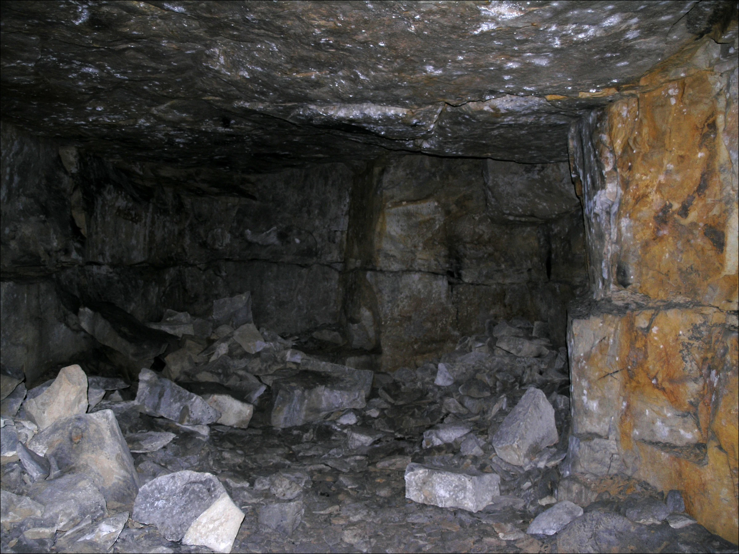
A view inside a dark, underground stone chamber with stacked opuka blocks and loose rock debris on the floor.
The interior of an underground opuka stone mine at the Vehlovické opuky natural monument.

Vehlovické opuky history and protected-area timeline

Vehlovické opuky has a documented history of stone extraction dating back to the 1870s. Historical sources from that period record that the opening of large quarries at Vehlovice was driven by the construction of the Polabská dráha, the railway line connecting Lysá nad Labem and Ústí nad Labem. Opuka was needed in volume for this construction and related building work, and the Vehlovice deposits proved well suited to the purpose.

Two horizons were worked. The lower opuka and the upper yellowish horizon, locally nicknamed žloutek, were both exploited. The yellowish opuka was particularly valued for the production of tiles, paving slabs, and troughs, and was also the focus of underground gallery (štoła) mining because of the quality and density of its layers. It is also the most fossiliferous level.

By the late 20th century the locality had fallen into serious neglect. By 1996, when it was proposed for protection, much of the area had been used as informal dumping ground and had effectively become an overgrown waste site, with the galleries largely inaccessible. Protection was formally declared on 1 January 2002 by the Mělník District Office.

After designation, the area was brought back to an appropriate condition. The entrances to the underground galleries, which host the bat colony, were fitted with grilles to allow continued bat access while preventing uncontrolled human entry. Since then, the monument has been managed by the Central Bohemian Regional Authority, and the site has remained a small but scientifically significant reference point for Bohemian Cretaceous geology and historical opuka mining.

Vehlovické opuky landscape and geographic character

The landscape of Vehlovické opuky is defined less by sweeping scenery than by the surface expression of small-scale former quarrying and the hidden architecture of underground galleries. Above ground, the protected area consists of low, disturbed terrain made up of former quarry faces, spoil, and access workings around the old mines. The setting is gently undulating lowland typical of the Polabí region north of Mělník, where the Elbe lowland meets the lower hills edging the Bohemian Cretaceous Basin.

The defining physical feature, however, is underground. Vehlovické opuky preserves a network of stoła, or gallery-style mines, cut into the yellowish upper opuka horizon. These passages are narrow and follow the bedding of the rock, giving them a stratified, layered profile. The walls preserve clear exposures of Cretaceous sedimentary structure, including the finely bedded, fossil-rich opuka that gives the site its name.

Because of the very small surface footprint of the protected area, the broader landscape surrounding Vehlovické opuky is more relevant than the reserve's own landforms. The site sits in farmland and lowland countryside a few kilometers north of Mělník, a region shaped by both the Elbe lowland and the geological fringe of the Bohemian Cretaceous Basin.

Vehlovické opuky ecosystems, habitats, and plant life

Ecologically, Vehlovické opuky is not a habitat-rich reserve in the conventional sense. Above ground, the surface is small and largely disturbed by historical quarrying and later dumping, so most of the site's nature value is concentrated underground rather than in surface vegetation or open habitats.

The dominant natural asset is the network of underground galleries, which functions as a stable microclimate refuge. The stoła maintain cool, humid, and sheltered conditions through the year, but they become especially important in winter, when they serve as a hibernation site for cave-dwelling bats. Conditions in the galleries are stable enough to support several bat species, including the lesser horseshoe bat.

The surface context provides limited but typical Central Bohemian lowland vegetation around former quarry margins. The most meaningful ecological story of the reserve is therefore not a surface biotope but a sheltered subterranean one, linked to and dependent on the preserved opuka galleries.

Vehlovické opuky wildlife and species highlights

Wildlife is a defining element of the site's protected status, even though most of the relevant fauna lives underground rather than in the open landscape. The galleries of Vehlovické opuky are a recognized bat refuge, used during winter by species that require cool, stable, and undisturbed subterranean conditions.

Among the recorded species, the lesser horseshoe bat (Rhinolophus hipposideros) is explicitly highlighted in the monument's conservation objectives. The presence of horseshoe bats and other bats in the stoła is one of the reasons the entrances are managed with grilles: to keep human disturbance low while still allowing the animals free access to the roost.

Beyond bats, the site does not present itself as a major general wildlife locality. Its ecological role is highly specialized: maintaining a quiet, secure hibernation site inside a network of historical mining galleries, at a scale small enough that microclimate and disturbance level matter far more than habitat area.

Vehlovické opuky conservation status and protection priorities

Vehlovické opuky was designated primarily for geological reasons, and its conservation significance reflects that. The site protects two complementary scientific assets: a fossil-rich exposure of the Jizera Formation within the Bohemian Cretaceous Basin, and a rare historical example of underground opuka extraction. Together these make the monument an unusually dense reference point for Cretaceous stratigraphy, paleontology, and Central Bohemian mining history.

A second conservation role is chiropterological. By maintaining quiet, undisturbed galleries, the site helps protect local bat populations that depend on subterranean roosts in winter. The installation of grilles at gallery entrances is a deliberate compromise: bat access is preserved, while uncontrolled human entry and disturbance are reduced.

At landscape scale, Vehlovické opuky is not a habitat-connector or large ecosystem reserve. Its conservation value is best understood as point-based and reference-based: a small locality that anchors knowledge of Bohemian Cretaceous geology and preserves a piece of regional quarrying heritage. The fact that such a small area was raised to natural monument status reflects the strength of its geological and paleontological material rather than ecosystem size.

Vehlovické opuky cultural meaning and human context

The cultural context of Vehlovické opuky is shaped by industrial and railway history rather than by settlement or traditional land use. The opening of the quarries in the 1870s is directly tied to construction of the Polabská dráha, the railway between Lysá nad Labem and Ústí nad Labem, which created strong demand for building stone in the region. The yellowish upper opuka, locally nicknamed žloutek, became a known local material used for paving slabs, tiles, and troughs.

Later, the underground galleries also acquired a different kind of local memory. Some sources reference the labyrinthine stoła as a place where local people sheltered during wartime air raids, adding an extra dimension of 20th-century social history to the site.

In the broader Central Bohemian context, Vehlovické opuky represents a small but characteristic piece of the region's building-stone heritage. Opuka has long been one of the most widely used local stones in Central Bohemia, and Vehlovice was one node in that wider quarrying tradition. The monument thus links paleontology, geology, mining technique, and everyday material culture into a single compact locality.

Top sights and standout views in Vehlovické opuky

Vehlovické opuky stands out for three combined strengths rather than for any single dramatic feature. Its fossil content is unusually rich within the Bohemian Cretaceous Basin, with an identifiable fauna of Cretaceous fish, crustaceans, and large bivalves such as Inoceramus lamarcki preserved in the Jizera Formation.

Its stratigraphic and mining-historical value is equally notable. The walls of the underground stoła expose a clear section of Cretaceous sedimentary rock, while the galleries themselves preserve a rare technique of underground opuka extraction. Few sites in Central Bohemia combine such geology with such direct, walkable evidence of historical quarrying.

Finally, the same galleries now shelter winter bat colonies, including the lesser horseshoe bat, making Vehlovické opuky a place where geology, fossils, mining heritage, and bat conservation overlap within just under one hectare of protected land.

Best time to visit Vehlovické opuky

Vehlovické opuky is a small protected geological monument rather than a landscape-scale destination, so seasonal timing matters mainly for comfort and accessibility rather than for dramatic scenery shifts. The site is most easily appreciated in the milder months of late spring, summer, and early autumn, when surface access to the small protected area around the old quarry is most comfortable and the surrounding lowland countryside around Mělník is at its most accessible.

Winter conditions in Central Bohemia can make the short visit uncomfortable, and the underground galleries, which host hibernating bats, are not open to general public access for conservation reasons. Therefore, while the monument itself is a year-round reference point for geology, the practical window for surface-level interest and surrounding countryside is wider in the warmer half of the year.


Monthly climate preview

Long-term representative point measurements tracking annual temperature and precipitation rhythm

Vehlovické Opuky Climate Normals, Average Temperature and Precipitation Patterns

Vehlovické opuky climate records outline measured monthly temperature bounds alongside daily precipitation averages derived from historical coordinate data. Examining the complete twelve-month normals dataset reveals detailed seasonal shifts across the protected terrain.
Annual mean9 °C
-2 °C20 °C
Jan-2°
Feb-1°
Mar
Apr
May14°
Jun18°
Jul20°
Aug19°
Sep14°
Oct
Nov
Dec-1°
Warmest month
July

19.8 °C

Coolest month
January

-2.3 °C

Wettest month
July

2.4 mm/day

Driest month
February

1 mm/day

Park location guide

Geography guide, regional context, and park location map for Vehlovické opuky

Vehlovické opuky park geography, regions, and map view in Czechia

Understand where Vehlovické opuky sits in Czechia through a broader geographic reading of the surrounding landscape, nearby location context, and its mapped position within the national park landscape.

How Vehlovické opuky fits into Czechia

Czech Republic is a landlocked Central European country with a population of approximately 10.9 million people. The nation was established as an independent state on January 1, 1993, following the dissolution of Czechoslovakia. Its capital and largest city is Prague, with other major urban centers including Brno, Ostrava, Plzeň, and Liberec.

Wider geography shaping Vehlovické opuky in Czechia

The Czech Republic is a landlocked country in Central Europe. It is bordered by Germany to the west, Austria to the south, Poland to the northeast, and Slovakia to the southeast. The landscape is predominantly hilly, with the territory covering 78,871 square kilometers.

Map view of Vehlovické opuky

Use this park location map to pinpoint Vehlovické opuky in Czechia, understand its exact geographic position, and read its mapped placement within the surrounding landscape more clearly.

Pigeon | © OpenStreetMap contributors

Location context for Vehlovické opuky

Středočeský kraj

Visualizing underground quarry galleries, rock strata, and protected habitat character

Vehlovické Opuky Photos and Landscape Views: Exploring Protected Geological Scenery

Visual records capture the distinctive terrain, exposed Cretaceous rock layers, and historical stone workings defining Vehlovické Opuky. Photographic documentation reveals the protected underground galleries and surrounding surface landscape in striking detail.

A view inside a dark, underground stone chamber with stacked opuka blocks and loose rock debris on the floor.

A low-angle view inside a dark underground mine or cave, showing layers of rough stone walls illuminated by artificial light against a deep shadow.

Park atlas

Compare surrounding regional reserves and connected geological landscapes across the Czech Republic.

Explore Other Parks Near Vehlovické opuky and Protected Areas in Central Bohemia

Continue browsing other parks near Vehlovické opuky to discover related geological monuments and protected landscapes across the surrounding region. Comparing adjacent protected areas provides deeper context into regional terrain and conservation networks.
A watercolor illustration depicting a soft, panoramic landscape of gentle, rolling green hills, scattered trees, and grassland areas with a muted color palette.
Nature reserveStředočeský kraj
About 5.3 km away#1 closest

Northeast

Na oboře Nature Reserve in Středočeský kraj: A Detailed Geographic Atlas Overview

Protected loess slopes and rare steppe ecosystems.

Na oboře comprises a series of south-facing slopes in the Středočeský kraj region, serving as a sanctuary for heat-loving flora and critically endangered insect species. The reserve features a rare geological intersection of wind-deposited loess and sandstone bedrock, forming a warm, mineral-rich landscape that remains a vital, mapped study area for steppe-like grassland conservation in the Czech Republic.

Area
0.034 km²
Established
2001
IUCN
IV
Relief
Upland
A soft, pastel-colored watercolor painting depicting a gentle landscape with a small pond in the foreground, grassy meadows, and distant rolling hills under a pale sky.
Natural monumentCentral Bohemia Region
About 13 km away#2 closest

South

Slaná louka u Újezdce: Protected Natural Monument and Regional Landscape Geography

A rare Natura 2000 lowland grassland in the Central Bohemia Region

Slaná louka u Újezdce preserves a compact lowland landscape defined by saline influences and calcareous soil substrates. This natural monument serves as an important ecological island, maintaining the steppe-like vegetation and halophytic flora that mark this specific Czech locality as a priority for habitat protection.

Area
0.014 km²
Established
2013
IUCN
III
Relief
Lowland
Natural monumentStředočeský kraj
About 14 km away#3 closest

Southwest

Veltrusy Natural Monument: Protected Woodland and Historic Park Geography in Středočeský kraj

English-style designed landscapes and floodplain ecological habitats.

Veltrusy Natural Monument is a protected area located on the right bank of the Vltava River, defined by its horseshoe-shaped layout and mosaic of oak-beech woodlands. The site represents a rare intersection of cultural heritage and nature conservation, preserving veteran trees that support significant invertebrate populations. Its geography consists of gently undulating floodplain terrain shaped by the Mlýnský potok, historic avenues, and managed meadows.

Area
2.555 km²
Established
2013
IUCN
III
Relief
Lowland
Natural monumentÚstecký kraj
About 16 km away#4 closest

Northwest

V kuksu Natural Monument: Mapping Protected Ravine Landscapes in Ústecký kraj

A vital orchid-rich habitat and Natura 2000 conservation area

V kuksu protects a specialized woodland ravine habitat characterized by stable humidity and shaded slopes. This natural monument serves as an important regional site for the lady's slipper orchid, contributing to biodiversity within the Litoměřice district through its status as a protected area of European importance.

Area
0.21 km²
Established
2011
IUCN
IV
Relief
Upland
A soft watercolor painting of a hilly landscape featuring pine trees and low-lying vegetation in shades of green, yellow, and red, with a pale background.
Natural monumentLiberec Region
About 21 km away#5 closest

North

Martinské stěny Natural Monument: Sandstone Cliff Geography and Protected Landscapes

Geomorphology and sandstone terrain in the Liberec Region

Martinské stěny features a prominent quartz sandstone cliff wall shaped by geological forces in the Bohemian Cretaceous Basin. This natural monument serves as a key protected area for heath and lichen communities, representing the unique cliff-side geography found throughout the Liberec Region in the northern Czech Republic.

Area
0.032 km²
Established
2002
IUCN
III
Relief
Upland
Natural monumentLitoměřice District
About 21 km away#6 closest

West

Vrbka Natural Monument: Exploring Protected Limestone Habitats and Bohemian Lowland Geography

A rare botanical reserve in the Litoměřice District of the Czech Republic

Vrbka Natural Monument protects a significant 15.5-hectare expanse of warm limestone slopes and dry meadows. This geographic landmark serves as an essential repository for rare orchid species and diverse insect populations, functioning as a representative habitat patch within the intensively cultivated landscapes of the surrounding region.

Area
0.155 km²
Established
2013
IUCN
IV
Relief
Upland
A horizontal watercolor illustration depicting a soft, rolling landscape with green hills, a small winding stream, and meadow vegetation on a white background.
Natural monumentÚstecký kraj
About 23 km away#7 closest

West

Na Dlouhé stráni Natural Monument: Regional Protected Area and Botanical Landscape

A conservation-focused look at the Mšenský potok valley slope

Na Dlouhé stráni is a designated natural monument in the Czech Republic, renowned for its concentration of thermophilous grassland flora. This protected area, located near Mšené-lázně, preserves a specific slope habitat that supports declining plant species. The site offers an important look at regional conservation efforts and the mapping of small-scale protected habitats within the diverse Ústecký kraj geography.

Area
0.126 km²
Established
2012
IUCN
IV
Relief
Lowland
A soft, light-filled watercolor painting of a rolling Czech landscape featuring deciduous trees, grassy meadows, and distant hills.
Natural monumentStředočeský kraj
About 25 km away#8 closest

Southeast

Slepeč Natural Monument: Protected Woodland Geography in the Central Bohemian Region

A rare botanical sanctuary in the Jizera basin.

The Slepeč natural monument represents a concentrated area of high botanical importance, shielding a remnant oak-hornbeam woodland from surrounding cultivation. Located in the Středočeský kraj, this site is renowned for housing diverse orchid species, including the lady's slipper, within a specialized microclimate found in the lowland terrain. Its protected status offers a unique look at forest conservation in an agricultural heartland.

Area
0.088 km²
Established
1984
IUCN
IV
Relief
Upland

Common questions about visiting, size, designation, and location context for Vehlovické opuky

Vehlovické opuky FAQs for park facts, access, geography, and protected area context

Find quick answers about Vehlovické opuky, including protected-area facts, park geography, trail and visitor context, and how the park fits into its surrounding country and regional landscape.
MoriAtlas Explorer

Continue Your Protected Areas Search Across the Global Atlas

Deepen your exploration by continuing the structured search for national parks and protected areas worldwide. Utilize the comprehensive filtering capabilities to compare different conservation landscapes and refine your understanding of global park geography. Discover more about the distribution and characteristics of protected natural areas.

Global natural geography