Mori Atlas logo
National parkWadden Sea National Park

Explore the mapped boundaries and unique protected landscape of Denmark's largest national park.

Wadden Sea National Park: A Vital Tidal Wetland and Migratory Bird Sanctuary in Denmark

(Nationalpark Vadehavet)

Wadden Sea National Park, Denmark's largest national park outside Greenland, protects a dynamic tidal wetland ecosystem of immense ecological importance. This protected landscape encompasses vast tidal flats, salt marshes, coastal dunes, and key islands like Fanø, Mandø, and Rømø. Renowned for its critical role as a stopover for millions of migratory birds and its spectacular 'sort sol' phenomenon, the park offers unparalleled opportunities for understanding coastal geography and protected area dynamics.

National ParkWetlandTidal EcosystemBird MigrationWorld Heritage SiteCoastal Landscape

Wadden Sea National Park

National park

Park overview

Structured park overview, official facts, and landscape profile for Wadden Sea National Park

Wadden Sea National Park park facts, protected area profile, and essential visitor context

Review the core facts for Wadden Sea National Park, including designation, size, terrain, visitor scale, habitats, and operating context in one park-focused overview.

About Wadden Sea National Park

Wadden Sea National Park represents Denmark's commitment to preserving one of the most distinctive and ecologically significant landscapes in Northern Europe. The protected area encompasses the entire Danish portion of the Wadden Sea, a shallow tidal lagoon bordered by a chain of barrier islands and fringed by extensive salt marshes along the mainland coast. This dynamic environment is shaped by the twice-daily tidal cycles that expose vast mudflats and sandflats, creating a constantly changing landscape of water channels, tidal pools, and exposed seabed that supports a rich and specialized ecosystem. The park extends from Ho Bugt in the north to the German border in the south, incorporating not only the open tidal waters and mudflats but also the three Danish Wadden Sea islands of Fanø, Mandø, and Rømø, each with their own distinct character and ecological communities. The mainland portion includes the Skallingen peninsula, the Varde Å river valley, and extensive areas of reclaimed and managed marshland that have been shaped by centuries of human interaction with the coastal environment. The national park is governed by the Danish Ministry of the Environment and operates from an office located in a historic parish house west of Rømø Church, with Prince Joachim of Denmark serving as patron of the Wadden Sea Centre, an educational facility dedicated to raising awareness about this unique environment.

Quick facts and research context for Wadden Sea National Park

Wadden Sea National Park covers the Danish section of the Wadden Sea, spanning from Ho Bugt to the German border in southwestern Denmark. The park was formally designated in January 2008 with the protected status taking effect in 2010, making it Denmark's largest national park. It includes the islands of Fanø, Mandø, and Rømø alongside extensive marshlands including Tjæreborgmarsken, Ribemarsken, and Tøndermarsken. The area has been a Ramsar wetland site since 1987 and became part of the Wadden Sea World Heritage Site in 2014, recognized as a transboundary site spanning Denmark, Germany, and the Netherlands. Approximately 97% of the park falls within the Natura 2000 European ecological network.

Protection and recognition

Documenting global conservation classifications and official Ramsar wetland designations.

Wadden Sea National Park Protection Status and Official International Recognition

Wadden Sea National Park features a mixed protection scope that reflects its critical status as a globally recognized natural reserve. National park status is supported by official designations, including the documented Ramsar site designation for conservation monitoring.

International recognition

Protection details

Protection scope
Mixed
Transboundary protection
No
Park context

Deeper park guide and search-rich context for Wadden Sea National Park

Wadden Sea National Park history, landscape, wildlife, and travel context

Explore Wadden Sea National Park through its history, landscape character, ecosystems, wildlife, conservation priorities, cultural context, and seasonal travel timing in a structured park guide built for atlas discovery and search intent.

Why Wadden Sea National Park stands out

Wadden Sea National Park is most renowned for its extraordinary significance as a migratory bird sanctuary. Each year, more than ten million birds pass through the Wadden Sea twice annually, using it as a crucial resting and feeding ground during their journeys between breeding and wintering areas. The park is famous for the spectacular 'sort sol' phenomenon, where massive flocks of European starlings gather in formation during autumn evenings, creating swirling aerial displays as they settle for the night in the marshlands. The ecosystem supports an exceptional diversity of life, with more than 500 species of plants and animals, including significant populations of breeding birds, fish, marine invertebrates such as starfish and blue mussels, and marine mammals.
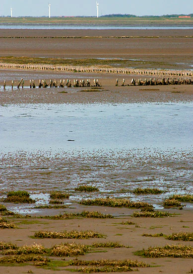
Wide landscape view of the Wadden Sea with tidal flats, shallow water, patches of vegetation, and a distant dam structure under a clear sky
View of the Wadden Sea tidal flats from Rømø dam, Denmark

Wadden Sea National Park history and protected-area timeline

The formal establishment of Wadden Sea National Park represents the culmination of decades of conservation effort and growing recognition of the Wadden Sea's international importance. The Danish government designated the area as a national park on 17 January 2008, with the official inauguration taking place on 16 October 2010 in the historic town of Ribe, attended by Prince Joachim of Denmark and Environment Minister Karen Ellemann. However, the protection of this area has deeper roots in Denmark's environmental policy. The Wadden Sea had already achieved international recognition as a Ramsar wetland site in 1987, establishing it as a wetland of international importance under the Ramsar Convention. The process of pursuing World Heritage status began in 2012 when then-Environment Minister Ida Auken and the municipalities of Varde, Fanø, and Esbjerg submitted a request to the Ministry of Culture for the Danish Wadden Sea to be nominated for UNESCO recognition. The formal application was submitted by Culture Minister Marianne Jelved in February 2013, and in June 2014, the Danish portion of the Wadden Sea was inscribed on the UNESCO World Heritage List as an extension of the existing German and Dutch Wadden Sea World Heritage site, creating a transboundary protected area spanning three nations.

Wadden Sea National Park landscape and geographic character

The landscape of Wadden Sea National Park is defined by the interplay of tidal forces, river systems, and coastal processes that have shaped this low-lying coastal region over millennia. The park encompasses a complex mosaic of habitats including expansive tidal flats that are exposed twice daily as the North Sea withdraws, leaving behind vast stretches of mud and sand interspersed with intricate networks of tidal channels that drain the exposed seabed. The coastline features a distinctive chain of barrier islands that act as natural barriers against North Sea storms, with the islands of Fanø, Mandø, and Rømø each presenting their own characteristic landscapes of dunes, beach meadows, and heath. The mainland coast is characterized by extensive salt marshes and reclaimed marshlands, with the Tjæreborgmarsken, Ribemarsken, Margrethekogen, and the outer dikes of Tøndermarsken representing areas where human engineering has worked alongside natural processes to create productive agricultural land while maintaining ecological connections to the surrounding tidal systems. The Skallingen peninsula and Varde Å valley add topographical variety to the otherwise flat coastal plain, while scattered dunes and sandplains provide microhabitats for specialized plant communities adapted to this harsh coastal environment.

Wadden Sea National Park ecosystems, habitats, and plant life

The ecological character of Wadden Sea National Park is defined by its position as a dynamic intertidal ecosystem where marine and terrestrial habitats meet and overlap in a complex zonation pattern driven by tidal exposure and salinity gradients. The tidal flats support dense populations of invertebrates including worms, clams, and crustaceans that form the base of a food web supporting enormous concentrations of birds and fish. The salt marshes and beach meadows provide specialized habitat for plants adapted to regular flooding and high soil salinity, while the dune systems host distinct communities of sand-tolerant species. The park's significance extends far beyond its immediate boundaries as a critical node in the East Atlantic Flyway, the major migratory route used by wading birds, waterfowl, and seabirds traveling between Arctic breeding grounds and African wintering areas. The sheltered tidal waters and extensive mudflats provide ideal feeding conditions for staging birds, allowing them to build the fat reserves needed to complete their often remarkable transcontinental journeys.

Wadden Sea National Park wildlife and species highlights

Wadden Sea National Park supports an extraordinary diversity of wildlife, with more than 500 species of plants and animals documented within its boundaries. The park's international reputation rests primarily on its significance as a migratory bird sanctuary, hosting millions of birds during the spring and autumn passage periods. The spectacular 'sort sol' phenomenon draws particular attention, with large flocks of European starlings gathering in autumn to perform their characteristic swirling aerial displays before settling into the marsh vegetation for the night. Beyond the starlings, the park supports important populations of breeding birds including numerous species of waders, terns, and waterfowl that nest in the salt marshes and on the islands. The tidal waters and channels support diverse fish communities, while the mudflats and rocky substrates provide habitat for invertebrates including starfish and the commercially important blue mussel. The ecosystem also supports marine mammals including seals that haul out on sandbanks and islands throughout the area.

Wadden Sea National Park conservation status and protection priorities

The conservation significance of Wadden Sea National Park is recognized at multiple levels, from national Danish environmental policy to international agreements and designations. Approximately 97 percent of the national park is included within the Natura 2000 network, Europe's ecological network of protected sites, divided among multiple designated areas including bird sanctuaries, wildlife sanctuaries, and Ramsar wetlands of international importance. The Ramsar designation, established in 1987, recognizes the Wadden Sea as a wetland of international importance particularly for waterbird habitat. The 2014 inscription on the UNESCO World Heritage List as part of the transboundary Wadden Sea World Heritage Site represents the highest level of international recognition, acknowledging the area's outstanding universal value as a dynamic coastal ecosystem that demonstrates ongoing natural processes and supports exceptional biodiversity. The park's management balances conservation objectives with sustainable use, with the official motivations emphasizing nature protection, cultural history preservation, outdoor activities, education and research, and international cooperation.

Wadden Sea National Park cultural meaning and human context

The Wadden Sea landscape has been shaped by centuries of human interaction, with the marshlands of southwestern Denmark representing areas where communities have developed specialized relationships with this challenging coastal environment. The islands of Fanø, Mandø, and Rømø each maintain distinct cultural identities connected to their maritime traditions and island isolation. The extensive system of dikes and drainage works that characterize the mainland marshlands represents generations of engineering effort to reclaim productive agricultural land from the tidal wetlands, creating the cultural landscape known as 'marsk' that remains a defining feature of the region. The historic town of Ribe, Denmark's oldest town, lies near the northern boundary of the park and has historical connections to the coastal environment that now falls within the protected area. This blend of natural and cultural landscape elements informed the national park's establishment, which explicitly includes cultural history preservation among its core objectives.

Top sights and standout views in Wadden Sea National Park

Wadden Sea National Park stands as Denmark's premier protected coastal wetland and one of Europe's most significant tidal ecosystems, earning international recognition through both Ramsar designation and UNESCO World Heritage status. The park's exceptional significance as a migratory bird sanctuary, hosting more than ten million birds during their seasonal passages, is unmatched in Denmark and ranks among the most important in the Wadden Sea region. The spectacular 'sort sol' starling murmuration represents one of nature's most impressive visual displays, drawing visitors from across Europe to witness the autumn aerial performances. The transboundary World Heritage status shared with Germany and the Netherlands underscores the need for international cooperation in managing this dynamic coastal system that respects no national boundaries.

Best time to visit Wadden Sea National Park

The Wadden Sea National Park offers distinctive experiences across seasons, though certain times of year offer particularly compelling reasons to visit. Autumn brings the famous 'sort sol' phenomenon as European starlings gather in vast flocks, creating spectacular aerial displays that are best observed during September and October when the birds are preparing for their southward migration. Spring migration, typically from March through May, offers excellent birdwatching opportunities as millions of birds pause to feed and rest in the mudflats during their journey northward to breeding grounds. The summer months provide opportunities to observe breeding seabirds and waders on the islands and salt marshes, though the experience is gentler than the dramatic seasonal concentrations. Winter offers a different character, with stark landscapes and the possibility of seeing seals hauled out on exposed sandbanks, though fewer visitors and shorter days limit exploration time. Regardless of season, the twice-daily tidal cycle fundamentally shapes the experience, with the exposed mudflats during low tide and the flooded channels at high tide presenting entirely different landscapes.

Park guides

Targeted wetland geography questions and seasonal migration reading material

Wadden Sea National Park Focused Guide Preview and Visitor Timing Insights

Selected readings provide focused answers to key questions about regional wetland geography and tidal ecosystems. Published materials examine optimal visitor timing relative to seasonal bird migrations and changing coastal conditions.
Monthly climate preview

Analyze long-term temperature patterns and precipitation ranges across the coastal coordinates.

Monthly Climate Normals and Weather Patterns for Wadden Sea National Park

Historical weather averages from 1991 to 2020 reveal a temperate maritime cycle at the representative elevation, ranging from cool winter mean temperatures near 1.5 degrees Celsius to mild summer peaks around 17 degrees. Accessing the complete monthly climate dataset provides structured comparisons of daily precipitation averages and seasonal trends throughout the year.
Annual mean9 °C
2 °C17 °C
Jan
Feb
Mar
Apr
May11°
Jun14°
Jul17°
Aug17°
Sep14°
Oct10°
Nov
Dec
Warmest month
August

17 °C

Coolest month
February

1.6 °C

Wettest month
October

3 mm/day

Driest month
April

1.5 mm/day

Park location guide

Geography guide, regional context, and park location map for Wadden Sea National Park

Wadden Sea National Park park geography, regions, and map view in Denmark

Understand where Wadden Sea National Park sits in Denmark through a broader geographic reading of the surrounding landscape, nearby location context, and its mapped position within the national park landscape.

How Wadden Sea National Park fits into Denmark

Denmark is a constitutional monarchy and Nordic country in Northern Europe. It is the southernmost of the Scandinavian countries, bordering Germany to the south, Norway to the north, and Sweden to the southwest. The country consists of the Jutland peninsula and an archipelago of islands, with Copenhagen as its capital and largest city. Denmark has a population of over 6 million and is characterized by flat, arable land, sandy coasts, and a temperate climate.

Wider geography shaping Wadden Sea National Park in Denmark

Denmark occupies the Jutland peninsula and roughly 406 islands in Northern Europe. It is situated between the North Sea to the west and the Baltic Sea to the east. The country borders Germany to the south and is connected to Sweden via the Øresund Bridge. Denmark is predominantly flat terrain with low elevation, the highest point being Møllehøj at 170.86 meters.

Map view of Wadden Sea National Park

Use this park location map to pinpoint Wadden Sea National Park in Denmark, understand its exact geographic position, and read its mapped placement within the surrounding landscape more clearly.

Pigeon | © OpenStreetMap contributors
Natural feature types

Explore the Geographic Landscapes of Wadden Sea National Park

Navigate the diverse natural terrain and mapped features that define Wadden Sea National Park. MoriAtlas provides a structured view of the tidal flats, barrier islands, and marshland networks within this significant North Sea ecosystem, connecting geographic data to broader landscape context.

Explore the distinct protected landscapes, coastal features, and significant bird habitats defining this UNESCO World Heritage Site in Denmark.

Wadden Sea National Park Landscapes: Detailed Photos of Tidal Flats, Salt Marshes, and Migratory Bird Habitats

Explore comprehensive imagery of Wadden Sea National Park, revealing its vast tidal flats, expansive salt marshes, and unique coastal ecosystems. These visual references are essential for understanding the park's dynamic intertidal terrain, critical migratory bird habitats, and its protected-area significance within the global Wadden Sea region.

Wide landscape view of the Wadden Sea with tidal flats, shallow water, patches of vegetation, and a distant dam structure under a clear sky

Park atlas

Trace the Mapped Geography and Connected Protected Landscapes of the North Sea Region and Danish Coast

Explore Nearby National Parks and Protected Areas Beyond Wadden Sea National Park, Denmark

Expand your exploration beyond Wadden Sea National Park to discover other national parks and protected areas throughout Denmark and the wider North Sea region. Compare diverse coastal landscapes, important wetland systems, and significant bird migration sites, gaining deeper geographic context and conservation insights for the region.
Watercolor illustration of a landscape with green hills, a body of water, and grassy foregrounds
National parkSchleswig-Holstein
Park boundaries overlap#1 closest

South

Schleswig-Holstein Wadden Sea National Park: Germany's Largest Protected Tidal Landscape

Explore the mapped geography of this vital North Sea national park.

Schleswig-Holstein Wadden Sea National Park is a monumental protected area, recognized globally as a UNESCO World Heritage Site for its extraordinary tidal wetland ecosystem. This page offers detailed insights into its geographic scope, from the North Frisian Islands to the Elbe estuary, highlighting the dynamic interplay of mudflats, salt marshes, and coastal terrain. Discover the park's critical role as a migratory bird flyway and marine nursery, providing rich data for geographic and atlas exploration of this unique North Sea protected landscape.

Area
4,410 km²
Established
1985
IUCN
II
Visitors
1.7M annual
Watercolor painting of a green salt marsh landscape with a winding river and wildflowers.
Protected areaDenmark
Mapped location lies within the park boundary#2 closest

Northwest

Skallingen Protected Area: Geography and Coastal Dynamics in the Danish Wadden Sea

Coastal peninsula landscape and tidal wetland geography

Skallingen is an active, naturally formed peninsula in Denmark, characterized by its horizontal gradients of beach, dune, and marsh. As a protected area within the wider Wadden Sea ecosystem, the land showcases the raw interplay of sediment and sea, offering a distinct look at one of Europe's most significant intertidal landscapes and its layered historical legacy.

Area
20 km²
Established
1634
Relief
Lowland
Climate
Temperate
A soft watercolor illustration showing a hazy coastal landscape with green dunes, rolling hills, and a calm water surface against a white background.
Protected landscapeDenmark
About 6.7 km away#3 closest

Northwest

Naturpark Vesterhavet: Geography and Protected Boundaries of the Danish West Coast

Coastal dune, heath, and wetland landscapes in West Jutland

Naturpark Vesterhavet serves as a critical coastal nature park along the North Sea, stretching between Blåvandshuk and Nymindegab. The park integrates a distinct series of parallel landforms, including active dunes, coniferous plantations, expansive heathlands, and the significant restored wetlands of Filsø. This protected landscape acts as a primary hub for coastal conservation, mapping the intersection of avian habitats and classic West Jutland terrain.

Area
225 km²
Established
2015
Relief
Lowland
Climate
Temperate
Nature reserveDenmark
About 14 km away#4 closest

Southeast

Draved Skov Nature Reserve: Mapping the Geography of Denmark's Primeval Forest Mosaic

A vital protected landscape in Southern Jutland featuring untouched forest and raised bogs.

Draved Skov provides an unparalleled look into natural lowland forest dynamics in Denmark. Covering 250 hectares of varying glacial terrain, this nature reserve showcases a complex mosaic of oak, linden, and alder ecosystems integrated with the expansive Kongens Mose raised bog, offering an essential look at Northern European wetland and woodland geography.

Area
2.5 km²
Established
1994
Relief
Lowland
Scope
Terrestrial
A pale watercolor landscape painting of a quiet fjord with soft green and pink marshy vegetation in the foreground and rolling hills in the background.
Protected areaRegion Midtjylland
17 km away#5 closest

North

Ringkøbing Fjord og Nymindestrømmen: Coastal Lagoon and Protected Wetland Geography

A vast Danish wetland complex in Region Midtjylland.

Ringkøbing Fjord og Nymindestrømmen defines the Danish west coast through its unique combination of brackish lagoons, salt meadows, and dune belts. This protected area integrates the Skjern Å river delta and the freshwater-lagoon chain of Nymindestrømmen, creating an internationally significant habitat for diverse waterbirds and migratory species across its multi-layered terrain.

Area
276.84 km²
Relief
Lowland
Climate
Temperate
Scope
Mixed
Protected areaSchleswig-Holstein
About 18 km away#6 closest

Southeast

FFH-Gebiet Wälder an der Lecker Au: Protected Forest Landscapes and Geest Geography

A mapped Natura 2000 deciduous woodland corridor in North Friesland

FFH-Gebiet Wälder an der Lecker Au comprises three specialized sub-areas of ancient deciduous woodland in Schleswig-Holstein. This protected landscape documents centuries of forest continuity, hosting diverse habitats including beech, oak, and alluvial forests that anchor the regional biotope network within the flat Lecker Geest terrain.

Area
0.5 km²
Established
2004
Relief
Lowland
Climate
Temperate
Protected areaRegion Midtjylland
25 km away#7 closest

North

Lønborg Hede Protected Area: Heathland Geography and Mire Ecosystems in Denmark

Detailed landscape analysis of a unique Central Jutland nature reserve

Lønborg Hede is a distinctive protected area featuring a rare micro-topographic gradient where inland dune heath rises 15 meters above wet bog and mire environments. This site provides a concentrated look at western Jutland's historical heathland character, featuring a mosaic of nutrient-poor aquatic habitats and diverse ground-nesting bird environments across 350 hectares.

Area
3.53 km²
Established
1970
Relief
Lowland
Scope
Terrestrial
Nature reserveCentral Denmark Region
32 km away#8 closest

North

Borris Hede Nature Reserve: Mapping the Protected Heathland of the Central Denmark Region

Glacial plains, wetland mosaics, and habitat conservation zones

Borris Hede encompasses a massive stretch of sandy outwash plain in central-western Denmark. This nature reserve serves as a vital habitat mosaic, ranging from dry and wet heath to bogs and riparian stream corridors. By preserving these open terrain characteristics, the site supports specialized birdlife and maintains one of the most distinctive geological and biological landscapes within the Danish geography.

Area
47.78 km²
Established
1903
Relief
Lowland
Climate
Temperate

Common questions about visiting, size, designation, and location context for Wadden Sea National Park

Wadden Sea National Park FAQs for park facts, access, geography, and protected area context

Find quick answers about Wadden Sea National Park, including protected-area facts, park geography, trail and visitor context, and how the park fits into its surrounding country and regional landscape.
MoriAtlas Explorer

Continue Your Protected Areas Search Across the Global Atlas

Deepen your exploration by continuing the structured search for national parks and protected areas worldwide. Utilize the comprehensive filtering capabilities to compare different conservation landscapes and refine your understanding of global park geography. Discover more about the distribution and characteristics of protected natural areas.

Global natural geography